
|
|
Area/Range |
|---|---|
|
|
44.30000°N / 114.58°W |
|
|
Hiking, Mountaineering, Scrambling, Skiing |
|
|
Spring, Summer, Fall, Winter |
|
|
7300 ft / 2225 m |
|
|
Sawtooth Range of Montana
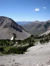
Headquarters Pass
The towering peaks of the Sawtooth Range provide any mountaineer/hiker some the best scenic views of the Bob Marshall wilderness. Being part of the Rocky Mountain Front, the Sawtooth Range offers an astonishing introduction to the Bob Marshall Wilderness, as most of the extremely popular trails such as the Teton Pass Trail, Headquarters Pass Trail, the W. Fork Teton Trail, and the Birch Creek Trails start here. The views from atop the tall mountains and ridges has the ability to knock hikers who frequent many popular areas over. Meadows and valleys provide amazing views of the surrounding area and mountains, and are bursting with wildlife such as Grizzly Bears, Mountain Goats, Bighorn Sheep, Ground Squirrels, Mountain Lions, Black Bears, Mule Deer, and the rare, but rewarding wolf sitings.

Mountain Goats of the Sawtooth Range
The alpine lakes that are doted throughout the area, usually lodged in between opposing peaks, not only offer a natural, untouched beauty, but allow fishing opportunities as well. These calm waters are crystal clear and full of mountain fish such as arctic greyling, Western-slope cutthroat trout, mountain whitefish, rainbow trout, and bull trout. The area provides an excellent pot of fly fishing opportunities as the Teton and Sun Rivers both have their sources within the Sawtooths.
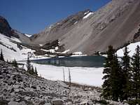
Our Lake (Hidden Lake)
The Sawtooth Range's many streams and creeks also feed the mouth of the Teton and Sun Rivers. The tops of the many popular peaks such as Mount Wright, Rocky Mountain, and Old Baldy provide some of the most excellent views in North Western Montana, providing sight of the peaks of Glacier National Park, a long stretch of the Eastern Plains, and even some of the peaks of the southern-most Scapegoat Wilderness, which is one of the most pristine, untouched additions to the Bob Marshall.

A Mountain Opposite Mount Wright After a Forest Fire in 2007
About an hour outside of the Sawtooth Range, the town of Choteau holds many interesting tourist attractions, the administrative headquarters for the area, and one of the best restaurants in Montana called the Elk Country Grill.
Geology of the Area
The Sawtooth Range has some very interesting geological features. Most the the peaks and ridges in the area are formed from ancient bedrock that sometimes runs for miles and miles. Many of the boulders and even some massifs are actually composed of limestone, which is formed when ancient ocean-dwelling creatures died and their shells floated to the bottom, forming a soft type of rock that frequently has some of these fossils still within them. One of the best spots for finding ancient ocean-dwelling fossils is atop Headquarters Pass or just Southwest of there, Rocky Mountain. The area is full of scree rock that is embeded with many sea shells and ancient coral-like fossils.Area Peaks and Summits

Rocky Mountain from Peak 8789 (Photo by Bob Sihler)
Rocky Mountain- 9392 ft/ 2863 m
Old Baldy(Devils Horns)- 9156 ft/ 2791 m
Mount Wright- 8875 ft/ 2705 m
Peak 8789- 8789 ft/ 2679 m
Mount Lockhart- 8682 ft/ 2646 m
Mount Patrick Gass- 8620 ft/ 2627 m
Mount Field- 8590 ft/ 2618 m

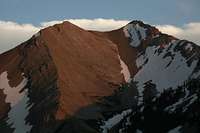
Teton Peak (Photo by Bob Sihler)
Teton Peak- 8416 ft/ 2565 m
Peak 8413(North Choteau Mountain)- 8413 ft/ 2564 m
Choteau Mountain- 8398 ft/ 2560 m
Mount Frazier- 8296 ft/ 2528 m
Mount Drewyer- 8236 ft/ 2510 m
Old Man of the Mountain- 8213 ft/ 2503 m
Mount Richmond- 8177 ft/ 2492 m
The Devil's Horns of Old Baldy
Bowl Mountain- 8100 ft/ 2468 m
Mount Werner- 8090 ft/ 2466 m
Bennie Hill- 7681 ft/ 2341 m
Bum Shot Mountain- 7544 ft/ 2299 m
Mount Sentinal- 7680 ft/ 2340 m
Wind Mountain- 6917 ft/ 2108 m
Getting There
Starting in the town of Choteau, travel Northwest on Highway 89 about 5 miles. Look on your left for a turnoff that says "Eureka Lake Resevoir". Follow this road for about 20 miles until you reach a fork in the road. One sign will point you in the direction of the S. Fork Teton Trails and the other will point you towards the W. Fork Teton Trails. The S. Fork Teton Trailhead includes areas on the Rocky Mountain Front such as Ear Mountain, Rierdon Gulch Trails and eventually, the Headquarters Pass/Hidden Lake trail. Following the Headquarters Pass Trail will put you in line for a free-hike to the top of the highest mountain in the area, Rocky Mountain. Following this trail will take you on a 13 mile hike towards the famous Gates Park through some rugged, but beautiful terrain. Following the road towards the W. Fork Teton Trail will take you towards a large variety of trails and mountains including the famous and ever-popular Cave Mountain. Other trails and mountains on the W. Fork road include the Teton Pass Trail, Mount Wright, and the very famous Birch Creek Loop.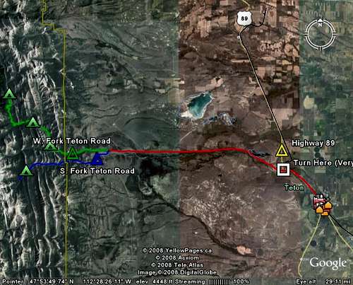
Road Map to the Sawtooth Range
Camping
Once you have taken the S. Fork Teton Road, there is a camping opportunity near the Headquarters Pass trailhead called the Mills Falls Campground. On the W. Fork Teton Road, there is a large variety of campgrounds. One of the more popular areas is the Cave Mountain Recreational Area which has the Cave Mountain Campground. The area is identified be a very large sign at a fork in the road. Just past Cave Mountain Recreational Area is the Elko Campground, a small turnoff campground to the right. Another Campground, located at the end of the W. Fork Teton Road, is the W. Fork Teton Campground.Red Tape/Hazards
BE ADVISED (2/27/09): Increased Mountain Lion Activity in the following camps: Elko Campground, Cave Mountain Recreation Area/Campground. Be sure to learn about the different ways to handle mountain lion encounters, as well as how to avoid them in the first place. The thing that makes mountain lion encounters different from bear encounters is that mountain lions, when sensing human activity, are actually attracted to it out of curiosity, whereas bears usually move away.In the last few decades, the Sawtooth Range has been affected by large wildfires. Pack extra waters because fire-charred trails provide very little shade from the sun and heat stroke is a REAL danger. Charred areas include all of Mount Wright, parts of Mount Lockhart, the latter half of the W. Fork Teton Road, parts of the Teton Pass Trail, and parts of the Birch Creek Trail.
Be sure to remember...the wildlife are WILD...they must be respected in order for their full beauty to be enjoyed. Give them their lee-way and do not provoke them or get to close.
Also be advised that most of the mountain lakes of the Sawtooth Range have been limited to camping. Most campsites must be established at least 1000 feet away from the shores of the lakes. This is not only a safety issue when it comes to curious bears who frequent most of the lakes, but it helps preserve the untouched beauty of the lake itself.
The U.S Forest Service usually places a limit on how close stock animals can get to the lakes, which are usually about 1,000 feet as well.
Bob Sihler - Aug 22, 2008 6:47 pm - Voted 10/10
Looking good...I like the way the page is shaping up! I deleted my other comments since they're now irrelevant. One last suggestion-- use a more scenic picture for the primary image. I think your picture "From the Base of Rocky Mountain" would make a good one. Just a suggestion, though.
SethP2343 - Aug 25, 2008 5:05 pm - Hasn't voted
Re: Looking good...No worries, i can do that...i also have more pictures from the Hidden Lake area (just got back from spendin two nights up there) and from the Birch Creek area near Swift Dam
SethP2343 - Aug 25, 2008 5:11 pm - Hasn't voted
Re: Looking good...and i also used your own picture for the main pic because it showed a much more scenic view of the best mountains of the sawtooth range