

-
 4558 Hits
-
 80.49% Score
-
 12 Votes
|
|
Route |
|---|---|
|
|
Trad Climbing |
|
|
Spring, Summer, Fall |
|
|
A long day |
|
|
5.8 (YDS) |
|
|
10 |
|
|
IV |
|
|
Overview
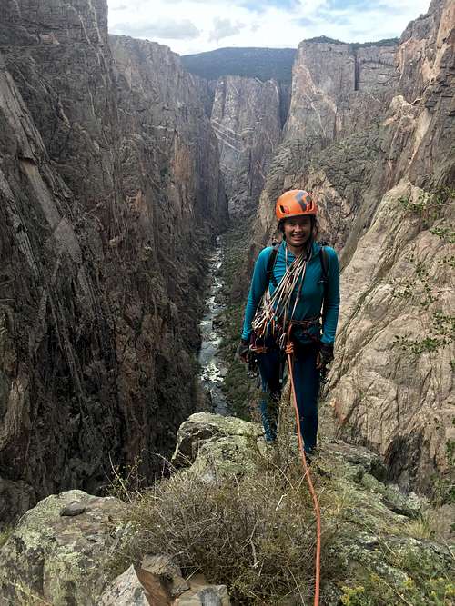
Top of Pitch 6 - Tourist Route
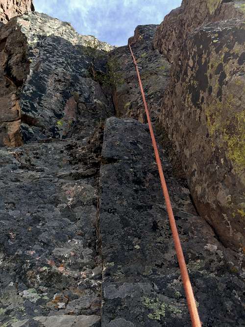
Pitch 10 - Tourist Route
Tourist Route is one of the long but technically moderate routes in the Black Canyon, and if one follows the easiest path, the route difficulty should stay at about 5.8 with some run out sections. The route is long - some pitches require 70 meter rope and none are shorter than 55 meters. It is 10 pitches long with a short scramble near the top. The views from this climb are spectacular and among the best! The climbing is varied from off width, chimney, face and cracks, you get to experience it all. I would rank Tourist Route among my favorite routes in the Black, and I will definitively repeat this one.
Tourist Route is located on the North Rim of the Black Canyon of the Gunnison and is accessed via Long Draw Gully. (Most climbs on the north rim are accessed via more traveled and shorter gullies like SOB gully, or Cruise Gully).
Mountain Project gives the route 5.9 R rating - there are a few variations of the route, but if you follow the path of least resistance, you can keep the route at 5.8 difficulty. Mountain Project also calls the route Rosy Arete/Tourist Route - there are some sections of the rosy rock higher up, but most of the rock is dark.
Mountain Projects is describing that the route finding is the crux. We did not find it too difficult. The start of the route had a small cairn at its base, and once we got on the route following the rock and topo was pretty straight forward (but we are used to climbing in the Black and this was my 14th route in the Black. I would not recommend it for novice climbers in the Black).
FA: Layton Kor has explored the area and climbed variation of this route (Rosy Arete). The name Tourist Route comes from Michael Covington, who guided his clients = tourists up this route multiple times. I spoke with Michael about the route - and he mentioned that this is his favorite route in the Black and the current route was explored by him.
With the new guidebook: The Black: A comprehensive Climbing Guide to Black Canyon of the Gunnison National Park by Vic Zeilman and his detailed route descriptions and topos, Tourist Route has become a lot more popular!
With the new guidebook: The Black: A comprehensive Climbing Guide to Black Canyon of the Gunnison National Park by Vic Zeilman and his detailed route descriptions and topos, Tourist Route has become a lot more popular!
North Rim is geared towards the climbers. You do need a free permit to climb - there is a box outside the tiny Ranger Station, where you can fill the paperwork. There is also a board where climbers write their name and routes they are intending to do.
Tourist Route faces north and northwest and it is inside a narrow and deep Long Draw - expect shade all day long except the upper pitches get sun in late afternoon.
![Long Draw]()
Long Draw
To reach the North Rim: Take Hwy 92 past the town of Crawford and turn right (west) onto the North Rim Road, follow the signs for the national park for 11 miles to the North Rim Ranger Station and the North Rim Drive. The first half of the road is paved; the second half is graveled, but suitable for all vehicles. The road and the North Rim Ranger station are closed in the winter.
Note there is no road that links the rims within the National Park - you have to drive around. It is more than 70 miles. Most visitors visit the more accessible and touristy South Rim.
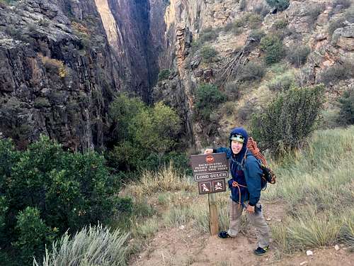
To reach the base of Tourist Route: you have to descend Long Draw: park at Big Island View (past the bend in the road).
Getting There
Long Draw
Note there is no road that links the rims within the National Park - you have to drive around. It is more than 70 miles. Most visitors visit the more accessible and touristy South Rim.
To reach the base of Tourist Route: you have to descend Long Draw: park at Big Island View (past the bend in the road).
Long Draw was formerly called Devil's Slide, Long Draw brings the hiker into one of the narrowest parts of the canyon where canyon walls tower above the swiftly moving Gunnison River. Long Draw is popular with fishermens.
From the bend in the road past Balanced Rock Overlook descent on the small trail - sign - expect a rocky terrain, steep, plenty of scrambling. There is a poison ivy along the bottom of this Long Draw, but none to the start of Tourist Route.
Long Draw is 1 mile long
Vertical Drop is 1800 feet (=550 meters)
Descent time: about 45 min (to the start of the climb) to 1 hrs to reach the river.
Route Description
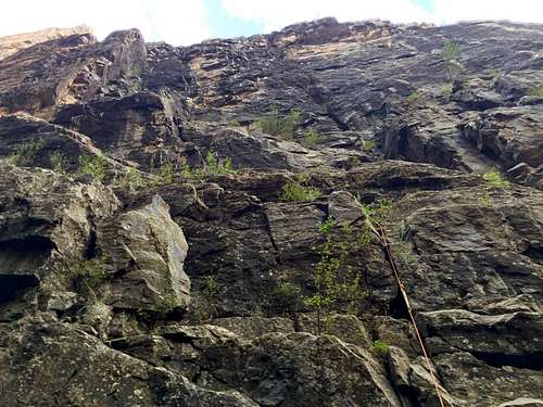
Pitch 1 - Tourist Route (note the pillar like feature with a smooth face on the photo up and left - that would be 2nd pitch of your climbing - chimney between this pillar and rock face)
Pitch 2 - Tourist Route
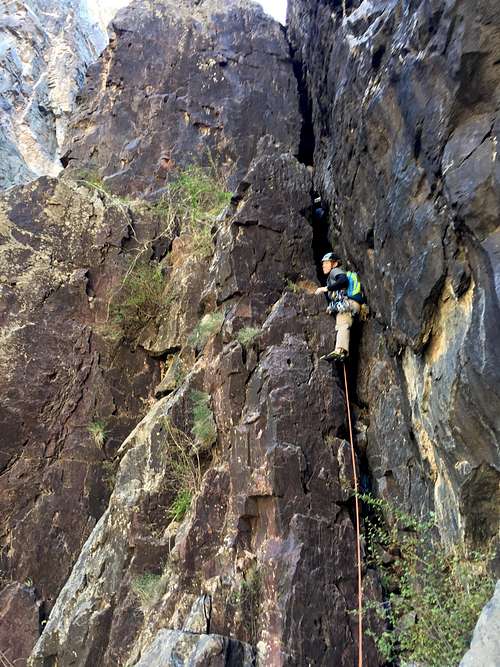
The route starts about 100 meters above the river, on the left side of the wall. Look for a pillar like feature higher up against the wall (pitch 2 climbs on this pillar), below is some easier terrain. There is a small cairn at the start. See the photo below showing the first pitch and the large looking pillar like feature.
Pitch 2: Enter the chimney, if you carry a back pack - sling it below you. The first few moves into the chimney start easy, then followed by a few awkward moves (5.7). Once above the chimney step across the chimney - exposed here! If this appears to be difficult move to the left and find and easier terrain to get across this step. Continue on 5.8+ face with a poor protection - PG 13 to a small ledge and another belay.
Pitch 3: Starts with a nice clean 5.8 corner and enters a trough like terrain, easier leading to a big chimney. We set up a belay station at the start of this chimney slot. 70 meters
Pitch 4: Stemming up the wide chimney, then moving to the left and using face holds.
Pitch 5: Move to the left on easier slabby terrain to reach a big ledge and follow this grassy ledge to the right - slightly uphill to a tree. A good place to rest and admire the views of the canyon and Gunnison river below. Half the route is done. You can spot people on Balanced Rock Overlook.
Pitch 6: Descent on the ledge to the right, slightly down hill, just a few meters to the start face with many small cracks on it. The views down into the canyon from pitch 6 and higher up get better and better. One of the most dramatic sections of the canyon!
Pitch 7: Slabby terrain into a crack system above. We rushed through this section - it was thundering, clouds rolling above us and started to drizzle, at some point raining pretty hard, but luckily it stopped quickly and sun came up again drying the rock fast.
Pitch 8: Starts with face climbing, higher up there are easy cracks going over a few small ledges.
Pitch 9: Hand cracks 5.7/5.8 over a few small ledges, head up and slightly to the left bypassing the big block above.
Pitch 10: Heads up and left over an easier terrain, past a corner where you find a crack 5.6/5.7 leading to a notch. We coiled our ropes here and scrambled to the summit. The final scramble was easy, but there was exposure! Less than 5 min bush whack will get you back to the road and near the Big Island Overlook.
Dow's description of the 5.10+ variation on Pitch 7 as well as the 5.9 splitter variation on Pitch 9
7th Pitch- 70m- 5.10+/ After finishing pitch six at a tiered ledge, the 5.9 off width that makes up the first half of this pitch is not in view, nor is the 5.10+ corner. Angle up and right on easy terrain until you can see the short 5.9 OW, the 5.10 corner is still hidden above but you can see where it is. A #3 protects the OW perfectly. Make a few moves at the grade (5.9) and you shortly land at the base of the right facing 5.10 corner. The first several meters are the crux, finger layback via finger pockets. Turn that into stemming in short order and a more continuous finger crack forms. After 15 meters you find good hands. Continue up to the base of precarious block. Pass it to the left side and up to a ledge the width of the broad face. A 70m just makes it to a good belay on this ledge. Dow
9th Pitch- 45m- 5.9/ The term “splitter” is being a bit generous regarding this seam in the orange lichen covered face above. Wander up 5.7/8 face to the base of the “splitter”. There is a loose block (more than likely directly above your belayer) about mid-way up the splitter, so beware. The finishing moves are stout for the grade. Trend up and left to a comfortable ledge with a nice sized block to sling. Dow
Essential Gear
- Personal climbing gear: harness, helmet, shoes
- 70 meter rope
- Standard rack with doubles up to camalot #3, we had also 2 camalots #4, but could suffice with one
- Plenty of long draws
- Anchor material (there is one anchor built in - slings around a large boulder/rock at the top of the first pitch, otherwise you are on your own).
- Food, energy bars, water, rain jacket
Camping
North Rim Campground is open from Spring to Fall. There are 13 sites in pinyon-juniper forest with vault toilets, tables and grills. Water is available mid-May to mid-September (we had no water in October). Please do not waste water, park rangers have to haul it in. All sites are available on a first-come, first-served basis (no reservations).
Fee: 16.00 per night.
Fee: 16.00 per night.
If the campground is full, you can drive back on the road you came in to BLM land and camp off on the dirt roads there. I have done it several times and actually prefer camping there more - more privacy
External Links
- Tourist Route on Mountain Project
- The new guide book to the Black
- Climbing weather: The Black Canyon (check the weather prior climbing, escape from this route is hard).
- National Park information about climbing in the Black