
|
|
Mountain/Rock |
|---|---|
|
|
45.32418°N / 7.22149°E |
|
|
Alpi Graie |
|
|
Mountaineering |
|
|
Summer |
|
|
9724 ft / 2964 m |
|
|
Overview
"Uja di Mondrone" summit is placed on the ridge between Val d' Ala and Val Grande is a remarkable mountain not for the height but for isolation, slender shape, and mountaineering history."Uja" locally means needle and is normally used to indicate a pointed mountain, this terms is used for a lot of summit in the Valli di Lanzo, like "Uja di Ciamarella","Uja diella Gura” and so on, but any other mountain explain the exact sense of this terms, for this reason locally "Uja di Mondrone" is simply called "Uja"!
|

Getting There
- From Turin motorway A55 exit Venaria Reale follow indications for Lanzo Torinese and go on through Germagnano and Ceres, here you enter in Val d'Ala, continue passing Ala di Stura, Mondrone and Molette in direction of Balme, after a bridge turn right on a secondary road in direction of Chialambertetto and Molera, cross again the river and turn right proceed a little bit and then turn on the left on a steep, narrow dirt road that with many turns reach the small village of Molette (1478 m.) before the village you’ll find indications for "Uja di Mondrone” and “Bivacco Molino”. You can also park at Molette in this case you can reach Molera by foot in 30 minutes.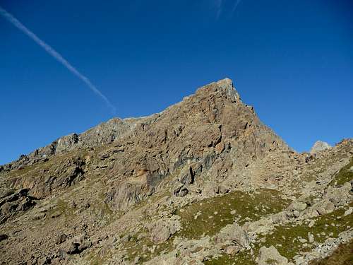
Uja di Mondrone - south / south west side
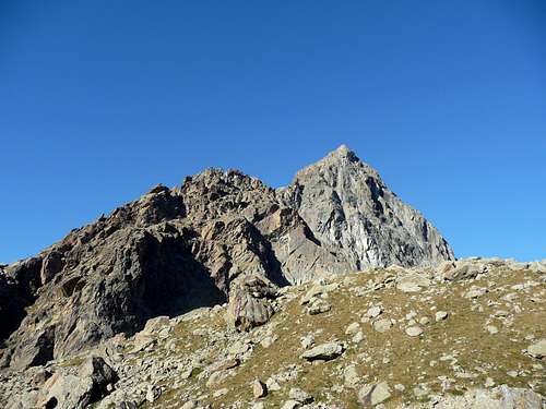
Uja di Mondrone - west / north west side
Red Tape
There are no fees or permits.Small parking at Molera, you can let the car on the side of the road or in a small park at Molette, there are no limitations for climbing and hiking. No problem for free camping.
Normal route
Here we describe the normal route on the south / south west side , this route is used also as descent route.From Molera (1478 m.) - Diff. F+ (II/II+), 3.30-4 h, 1486 m.
The rock is the ultrabasic massif, which covers most of the Lanzo’s valleys, with serpentine and prasina, but here there is a red serpentine with a formidable grip and this is certainly one of the reasons that have made famous the Uja.
But occasionally the serpentine is crossed by blue veins of talc, which are very slippery especially when wet!
CAUTION, bad weather conditions may decree a very fast increasing of difficulties and dangers.
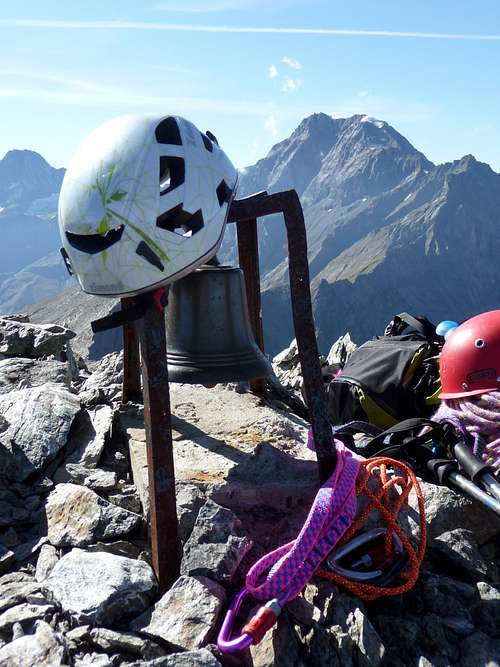
Uja di Mondrone - Summit
From Molette, nearly the end of the road there is a visible signpoint for " Bivacco Molino ", follow the indications (red/white painted signpoints) of Grande Traversata delle Alpi (GTA) path. Proceed in the wooded area and reach a typical stone made house called “Alpe Pian Bosco” (1673 m). At this point the GTA trail splits. Pass the chalets on the right, rises above them (red painted signpoints) and continue for a good while, following the right watershed of a dry gully. Then proceed on the left rising diagonally in the larches. Pass at the base of a clear cliff and continue on a sequence of turning, overcome a grassy ridge from which you exit, keeping left, to reach a huge rock (1970 m).
Toward left and soon you reach a little marked depression invaded by giant blocks, here there is the junction of the trails 232 (leading to the Uja di Mondrone summit) and 233 for " Bivacco Molino ".
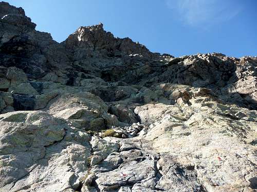
Turn left (trails 232) on a stony ground trail, then the route starts to climb again in the direction of a grassy ridge toward W on the top of a rocky area. Here you reach the south side of Uja di Mondrone, proceed into the large main gully, on a very steep trail until you reach the rocky area.
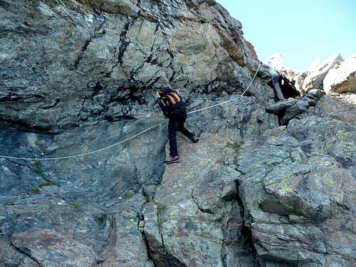
At this point follow the red painted signposts (recently renewed) with an easy climb, with some pass on vertical and exposed rock, but well foothold (II/II +) and two fixed ropes.
DESCENT: Descend on the same route.
Uja di Mondrone normal route
Uja di Mondrone normal route
When To Climb
The best time is from May or June (depending of snow quantity and conditions) to October.First Ascents
S-SW wall: A. Tonini and Ambrosini – 1857S ridge (First winter ascent): E. Martelli, L.Vaccarone, A. Castagneri "Toni di Touni", G. and P. Castagneri– Dec 24, 1874 (this is also the first winter Italian climb).
N-NW ridge “Ometto ridge”: G. Corrà and M. Richiardi Aug. 28,1884.
W ridge: L. and D. Delleani, A. Castagneri "Toni di Touni"and G. Bricco - June 29, 1886
WSW wall, (normal route from Balme): L. Sinigaglia, A. Castagneri "Toni di Touni" and A. Bogiatto Oct. 1st 1888.
E ridge: G.A. De Petro – June 19,1921.
NE side: T. Ortelli, E. and V. Biino – Oct. 15, 1925
N wall: A. Ribetti, D. G. and S. Rosenkrantz Aug. 11, 1939
N wall: P. Chironna and G. Rossa – July 10,1955
N wall: G. Dionisi and G. Marchese – Sept. 16, 1956
NW wall: F. Ribetti and L. Fava – Sept. 29, 1957
N wall: C. Carena, G.P. Motti and I.Pivano - Sept. 29, 1968
N wall: G.C. Grassi and M. Ala – Aug. 8, 1981
SUMMIT BOOK

Uja di Mondrone – N wall routes
Accomodations
You can find accommodations in all villages of Valli di Lanzo.You can use Bivacco Molino (m.2280) as base for the ascents to Uja di Mondrone N wall and N-NO ridge.
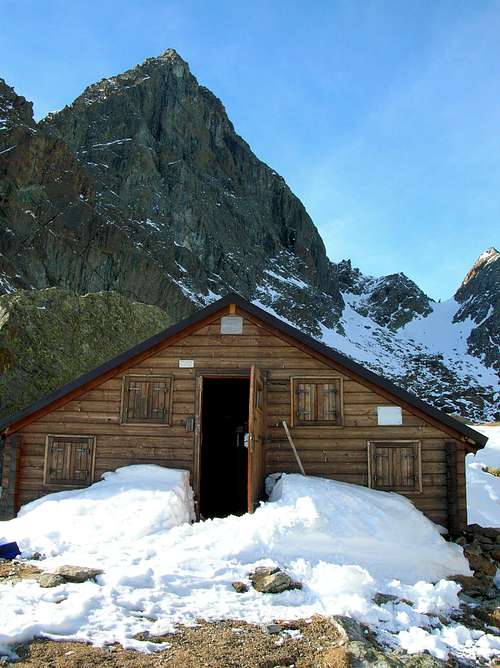
Uja di Mondrone and Bivacco Molino
Books and Maps
-BOOKS- G. Berruto, L. Fornelli " Guida dei Monti d'Italia ? Alpi Graie Meridionali" Club Alpino Italiano/Touring Club Italiano (1980). (Italian)
google books - Guida dei Monti d'Italia - Alpi Graie Meridionali
MAPS
- IGC- Istituto Geografico Centrale
N° 103, 1:25.000
Rocciamelone Uja Di Ciamarella Le Levanne
- ASF- Alpi senza frontiere / Alps without frontiers (IGN Institute Geographique National)
N° 13, 1:25.000
Mont-Cenis Ciamarella
- IGC- Istituto Geografico Centrale
N° 2, 1:50.000
Valli di Lanzo e Moncenisio
 |
Mountain Conditions
You can get whether forecast at this site:www.nimbus.it
www.regione.piemonte.it official site of the Regione Piemonte
www.meteofrance.fr
Miscellaneous Info
Useful:Mountain Rescue phone n°: Italy 118 , France 04 79 05 11 88
Avalanche Bulletin: www.aineva.it
Union of Mountain Guides (Piemonte-Valle d'Aosta) phone n°: +39 011 5171628