
-
 27775 Hits
-
 87.76% Score
-
 25 Votes
|
|
Area/Range |
|---|---|
|
|
46.82000°N / 12.39000°E |
|
|
9721 ft / 2963 m |
|
|
Introductory Note
This group page is a joint effort between Mathias Zehring and me. Mathias has contributed almost all of the long overview section as well as all the “unusual” sections about pastures, winter sports etc. I only took the liberty to correct some typos, “improve” the formatting and including some links. My job has been the structuring of the group respecting subgroups, the summit listings and the maps. Several of the sections – like “Weather Conditions” or “Maps and Books” are joint efforts.Before Mathias takes over with the overview, let me say that I’m looking forward to doing this kind of collaboration more often and with different members in the future.
Overview
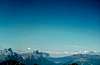
 Villgraten Group Panorama from the south Villgraten Group Panorama from the south |
The Villgraten Group (Villgrater Berge in German) is part of Hohe Tauern, and forms - together with the Rieserferner Group - the southernmost part of the whole mountain range. In character it seems to be a world apart with no summit topping 3000m and none of the glaciers for which Hohe Tauern are so famous. From the geological perspective, however, there can be no doubt.
The group is a quiet mountain range where you won't find masses of tourists or even hikers. If you want to climb summits you have to cope with notable elevation differences. Many mountains are perfect lookout peaks since they are in an ideal position between the glaciers around Grossvendiger and Grossglockner in the north and the rocks of the Sexten/Sesto and Lienz Dolomites in the south. Just have a look at the pages of Gumriaul and Hochgrabe, which have already been posted to SP (or look at some of the panos below).
Dolomites Panorama
 |
 |
 |
 |
 |
 |
Carnic Alps Panorama
 |
 |
 |
Tauern Panorama
 |
 |
 |
 |
 |
 |
For mountaineers these mountains have are most popular in winter time since they are perfect for tour skiing. If snow conditions permit a week's holiday in either the valley of Villgraten or Gsies between January and March can be recommended warmly.
There is no real main mountain of the group. The highest one is Weisse Spitze (2963 m), but Rote Spitze (2956 m), Grosses Degenhorn (2946 m), Hochgrabe (2951 m), Goelbner (2943 m) and Gumriaul (2918 m) are not much behind.
Geography
 Overview Map of the Hohe Tauern Range
To the north the group borders on the groups of Rieserferner, Venediger and Schober of Hohe Tauern, to the south – beyond the Pustertal Valley - there are the (Sexten/Sesto) Dolomites, the Carnic Alps and the Gailttal Alps (with the subgroup of the Lienz Dolomites).
The boundaries of the Villgraten Group are clearly defined by:
- West: the Antholz / Anterselva Valley and Staller Sattel Pass (Italian-Austrian border)
- North: the Defereggen Valley between Staller Sattel and Huben
- East: Tauern (Isel) Valley between Huben and Lienz
- South: Pustertal Valley between Olang and Lienz.
The name of the group stems from the central valley which leads into the heart of the group and to its highest mountains - the Villgraten Valley. In several publications you can see the group referred to as "Defereggen Alps", but the Defereggen Valley provides only the northern border. Besides the Villgraten Valley there is another populated valley within the heart the group, the Gsies / Casies Valley in South Tyrol, Italy.
The main ridge of the Villgraten Group runs in west-easterly direction, starting at Stallersattel in the west and ending at Hochstein near the city of Lienz. It is a long ridge, which at first follows the Italian – Austrian border. There are several long side ridges to the south which – except for one ridge are considered as separate subgroups here. The side ridges to the north are rather short, often consisting of not more than 2 or 3 summits, so that these north ridges are treated in unison with the main ridge.
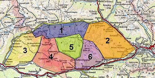 Overview Map of the Villgraten Group
The subdivision of the group will be defined as follows:
- Main Ridge West (west of Villgrater Joch)
- Main Ridge East (east of Villgrater Joch)
- Rote Wand Group (between Antholz and Gsies)
- Riepenspitze Group (between Gsies and Villgraten)
- Hochgrabe Group (between Villgraten and Winkeltal Valley)
- Gölbner – Gumriaul Group (between the Winkeltal and Kristeiner Tal Valleys)
All the passes will be denoted in GREEN!
1 - Main Ridge West
The main ridge of the Villgraten Group runs in west-easterly direction, starting at Stallersattel in the west and ending at Hochstein near the city of Lienz. There are quite many important passes and since the main ridge is so long I divided it in two parts right in its middle at Villgrater Joch Pass. The western part shows a small number of short northern side ridges. Most of the refuges which are listed below can be found here. The westernmost part of the main ridge runs along the Italian – Austrian border so that most of the mountain have double names here.
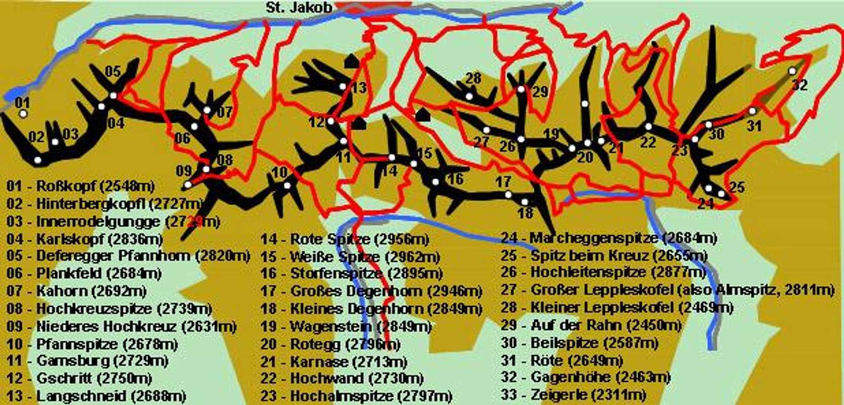
Stallersattel through Villgrater Joch
- Stallersattel (2052m)
- Roßkopf (2548m)
- Hinterbergkofel / Monte di Dentro (2727m)
- Halsscharte / Bocchetta del Colle (2549m)
- Innerrodelgungge / Monte Conca (2729m)
- Feldscharte / Bocchetta del Campo (2643m)
- Karlskopf / Monte Quaira (2836m)
- Deferegger Pfannhorn / Corno Fanna (2820m)
- Gsieser Törl / Forca di Casies (2205m)
- Plankfeld / Campo Planka (2684m)
- Kahorn (2692m)
- Hochkreuzspitze / Monte Alta Croce (2739m)
- Mittleres Hochkreuz / Monte Croce di Mezzo (2702m)
- Niederes Hochkreuz / Monte Croce Basso (2631m)
- Pfoisattel / Sella di Foi (2618m)
- Hellböden / Monte Chiaro (2711m)
- Pfannspitze (2678m)
- Villgrater Törl (2502m)
- Plattetörl (2552m)
- Gamsburg (2729m)
- Gschritt (2750m)
- Rote Spitze (2956m)
See the Rote Spitze Page for more information.
![Villgraten Group photo_id=133701]()
![Villgraten Group photo_id=133686]()
![Villgraten Group photo_id=133683]()
- Weiße Spitze (2962m)
![Villgraten Group photo_id=128859]()
![Villgraten Group photo_id=128888]()
- Storfenspitze (2895m)
- Großes Degenhorn (2946m)
See the Großes Degenhorn Page for more information.
- Kleines Degenhorn (2849m)
- Ochsenlenke (2744m)
- Wagenstein (2849m)
![Villgraten Group photo_id=128889]()
- Rotegg (2796m)
![Villgraten Group photo_id=128887]()
![Villgraten Group photo_id=128886]()
- Karnase (2713m)
![Villgraten Group photo_id=128884]()
![Villgraten Group photo_id=128885]()
![Villgraten Group photo_id=128883]()
- Gsaritzer Törl (Waldtörl, 2561m)
- Hochwand (2730m)
![Villgraten Group photo_id=128882]()
- Kleinitzer Lenke (Zeigetörl, 2614m)
- Hochalmspitze (2797m)
![Villgraten Group photo_id=128881]()
- Marcheggenspitze (2684m)
- Spitz beim Kreuz (2655m)
- Villgrater Joch


1st northern side ridge (starting at Wagenstein)
- Hochleitenspitze (2877m)
- Großer Leppleskofel (also Almspitz, 2811m)
- Kleiner Leppleskofel (2469m)
- Auf der Rahn (2450m)
2nd northern side ridge (starting at Hochwand)
- Beilspitze (2587m)
3rd northern side ridge (starting at Hochalmspitze)
- Röte (2649m)
- Gagenhöhe (2463m)
- Zeigerle (2311m)
- Penzenkopf (2232m)
2 - Main Ridge East
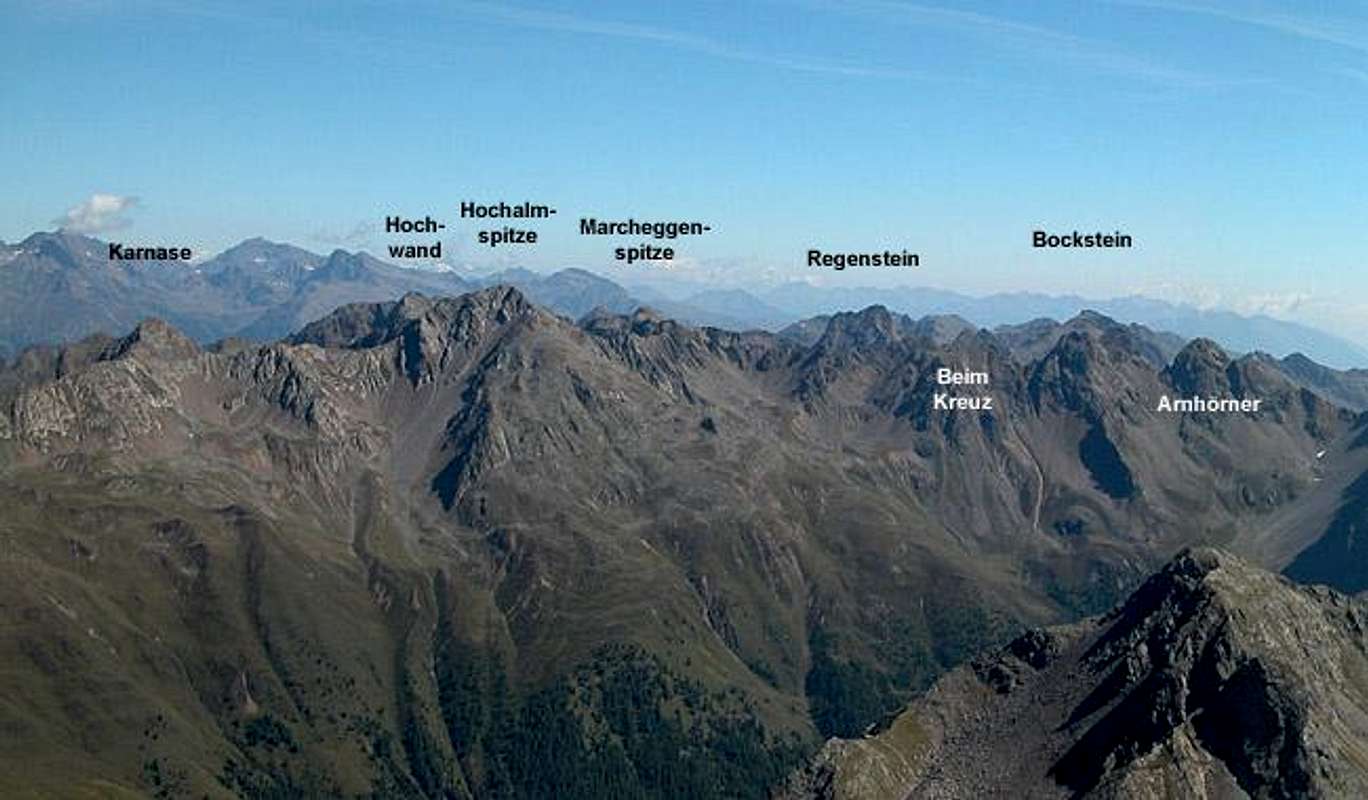
The eastern part of the main ridge starts off with the impressive peaks of Regenstein and Bockstein but then gets gradually lower and lower. The last (easternmost mountain, Hochstein, barely tops 2000m. It is, however, one of the most popular downhill skiing destinations within the Villgraten Range (see below). This listing of the main ridge includes several northern side ridges as well as a southern one. The latter is rather large in terms of covered area but contains only two summits.
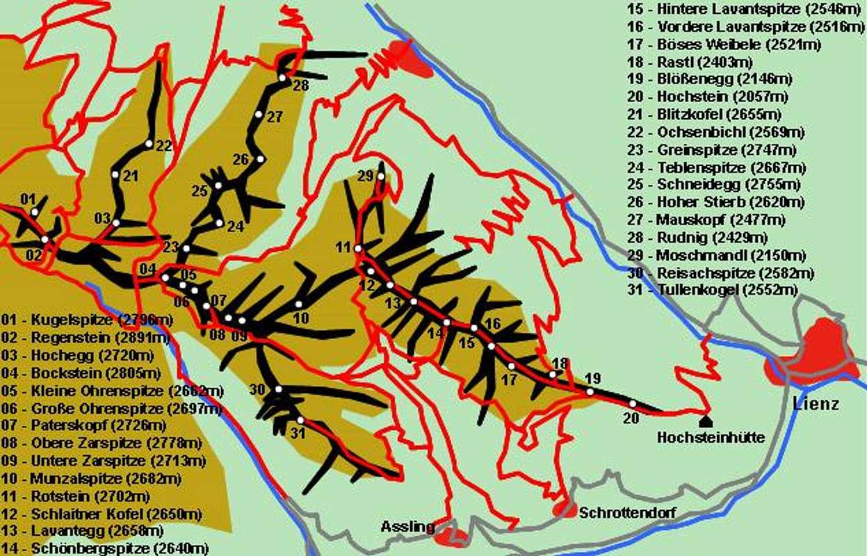
Villgrater Joch through Hochstein
- Kugelspitze (2796m)
- Regenstein (2891m)
- Hochegg (2720m)
- Bockstein (2805m)
- Kleine Ohrenspitze (2662m)
- Große Ohrenspitze (2697m)
- Paterskopf (2726m)
- Obere Zarspitze (2778m)
- Untere Zarspitze (2713m)
- Munzalscharte (2530m)
- Munzalspitze (2682m)
- Gelenkscharte (2518m)
- Rotstein (2702m)
- Schlaitner Kofel (2650m)
- Lavantegg (2658m)
- Schönbergspitze (2640m)
- Hintere Lavantspitze (2546m)
- Vordere Lavantspitze (2516m)
- Böses Weibele (2521m)
- Rastl (2403m)
- Blößenegg (2146m)
- Hochstein (2057m)
4th northern side ridge (starting from Hochegg)
- Blitzkofel (2655m)
- Ochsenbichl (2569m)
5th northern side ridge (starting from Bockstein)
- Greinspitze (2747m)
- Teblenspitze (2667m)
- Schneidegg (2755m)
- Hoher Stierb (2620m)
- Mauskopf (2477m)
- Rudnig (2429m)
6th northern side ridge (starting from Rotstein)
- Moschmandl (2150m)
Southern ridge (starting from Zarspitzen)
- Reisachspitze (2582m)
- Tullenkogel (2552m)
3 – Rote Wand Group

This is the westernmost of the important southern side ridges of the Villgraten Group. It separates the Antholz Valley (Valle di Anterselva) from the Gsies Valley (Valle di Casies). The whole ridge is located on Italian territory so that many of the mountains carry two names. In the following listing I have used both names wherever I could find them. The maps use only the original German names. Actually one can speak of two side ridges here, both starting from Hinterbergkofll on the main ridge. The eastern of the two ridges, however, is very short so that both are discussed in conjunction.The highest and most important mountain of the ridge is Rote Wand, which can be reached via four different routes. The most popular one starts at Stallersattel and ascends for more than 800m.
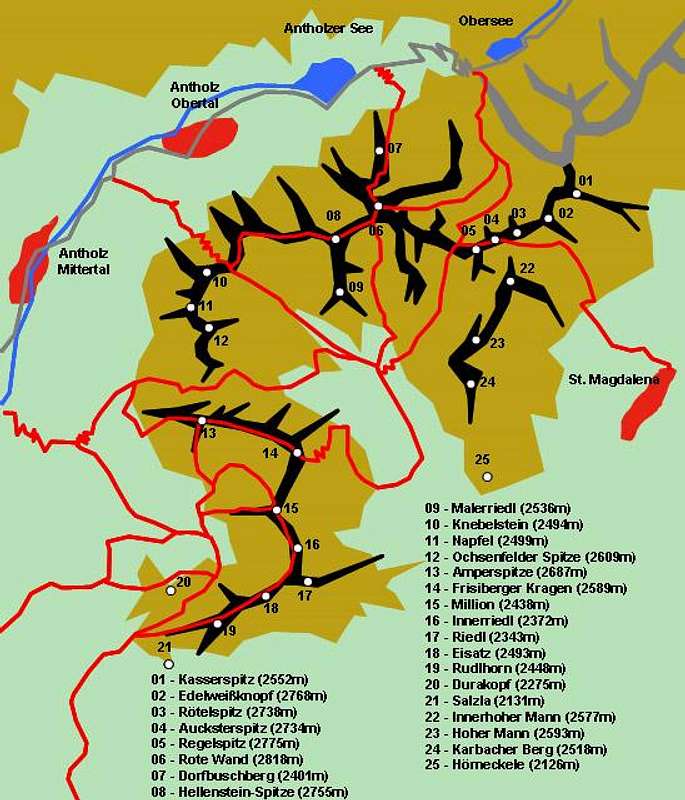
Western Ridge
- Kasserspitz / Pizzo Casera (2552m)
- Edelweißknopf (2768m)
- Rötelspitz (2738m)
- Aucksterspitz (2734m)
- Regelspitz / Monte Regola (2775m)
- Regelscharte / Forcella di Monte Regola (2644m)
- Rote Wand / Croda Rossa (2818m)
There will be a Rote Wand page in a couple of weeks so be patient.
- Dorfbuschberg (2401m)
- Hellenstein-Spitze / Pietra Forata (2755m)
- Malerriedl / Monte Masseria (2536m)
- Grübl-Scharte / Forcella della Fossa (2394m)
- Knebelstein / Monte Sbarra (2494m)
- Napfel (2499m)
- Ochsenfelder Spitze / Campo Bove (2609m)
- Ampertörl / Forcella di Somma (2413m)
- Amperspitze / Monte Costa (2687m)
- Frisiberger Kragen / Monte Frisio (2589m)
- Million (2438m)
- Innerriedl / Monte Novale di Dentro (2372m)
- Riedl (2343m)
- Eisatz / Monte Novale di Fuori (2493m)
- Rudlhorn / Roda di Scandole (2448m)
- Durakopf / Monte Salomone (2275m)
- Salzla / Monte di Tesido (2131m)
Eastern Ridge
- Innerhoher Mann (2577m)
- Hoher Mann / Monte Alto (2593m)
- Karbacher Berg / Monte Quaira (2518m)
- Hörneckele / Cornetto (2126m)
4 – Riepenspitze Group
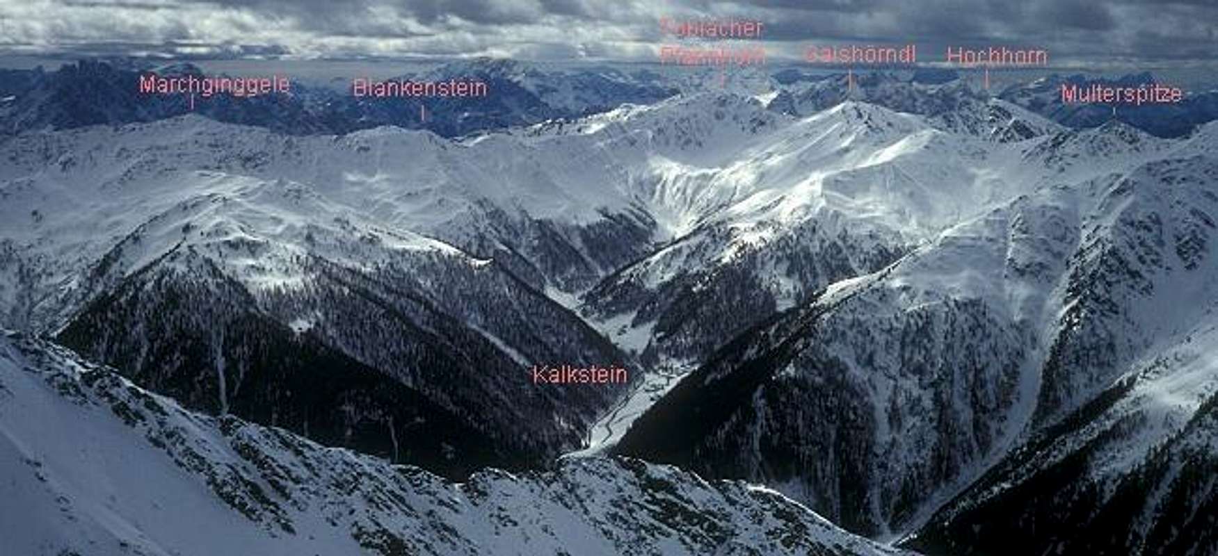
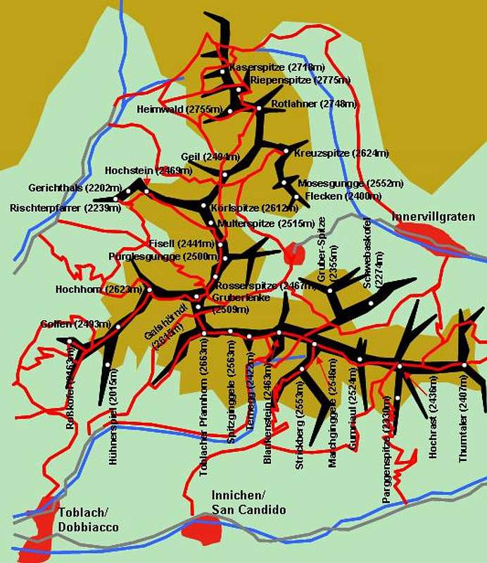
Touristically this is probably the most important of the side ridges in the Villgraten Group. Definitely it is the longest. It starts at Pfoisattel, (where the main ridge leaves the Austrian – Italian border) and follows the border almost to its end. The main ridge is S-shaped and there are several secondary side ridges which will be included at the end of this listing. The highest summit, Riepenspitze, can be found in the vicinity of the main ridge while the most important ones are Hochstein, Hochhorn and Toblacher Pfannhorn, all perfect lookout peaks which are located a little west of the ridge. As for the names the summits on the border as well as on its Italian side have two names (in both languages) whereas the ones on the Austrian side only carry German names.
Main Ridge
- Hintere Gsieser Lenke / Forcella di Foi Nord (2539m)
- Vordere Gsieser Lenke / Forcella di Foi Sud (2588m)
- Kaserspitze (2718m)
- Riepenspitze / Monte Ripa (2775m)
- Heimwald / Monte Bosco (2755m)
- Heimwald-Joch (2644m)
- Rotlahner / Giogo del Bosco (2748m)
![]()
- Geil / Monte Colle (2494m)
- Kalksteiner Jöchl / Forcella di Chiarnil (2326m)
- Körlspitze / Pizzo Quadra (2612m)
- Multerspitze / Pizzo Madre (2515m)
- Fisell / Bocchetta di Vallesella (2441m)
- Pürglesgungge / Pizzo di Vallesella (2500m)
- Rosserspitze / Pizzo Rosso (2467m)
- Gruberlenke / Costei di Vallesella (2509m)
- Gaishörndl / Cornetto di Fana (2615m)
![]()
- Pfanntörl / Bocchetta di Fana (2511m)
- Toblacher Pfannhorn / Corno di Fana (2663m)
![]()
- Spitzginggele (2563m)
- Ternegg (2422m)
- Blankenstein / Sasso Planca (2463m)
- Marchginggele / Cornetto di Confine (2546m)
- Gumriaul (2524m)
- Hochrast / Pausa Alta (2436m)
- Parggenspitze (2330m)


1st eastern side ridge (starting at Rotlahner)
- Kreuzspitze (also Eggeberg, 2624m)
![]()
- Mosesgungge (2552m)
- Flecken (2400m)

2nd eastern side ridge (starting at Hochrast)
- Thurntaler (2407m)
1st western side ridge (starting at Körlspitze)
- Hochstein / Sasso Alto (2469m)
There will be a Hochstein page soon so be patient.
- Gerichthals (2202m)
- Rischterpfarrer / Corno di Vallesella (2239m)
2nd western side ridge (starting at Gaishörndl)
- Hochhorn / Corno Alto (2623m)
![]()
- Golfen / Monte Calvo (2493m)
![]()
- Roßkofel / Monte Cavallo (2163m)
![]()
- Hühnerspiel / Dosso Gallina (2015m)


1st southern side ridge (starting at Marchginggele)
- Strickberg / Monte della Chiesa (2553m)
1st northern side ridge (starting at Marchginggele)
- Gannekofel (2488m)
- Gruber-Spitze (2355m)
- Schwebaskofel (2274m)
- Prantekammern (2001m)
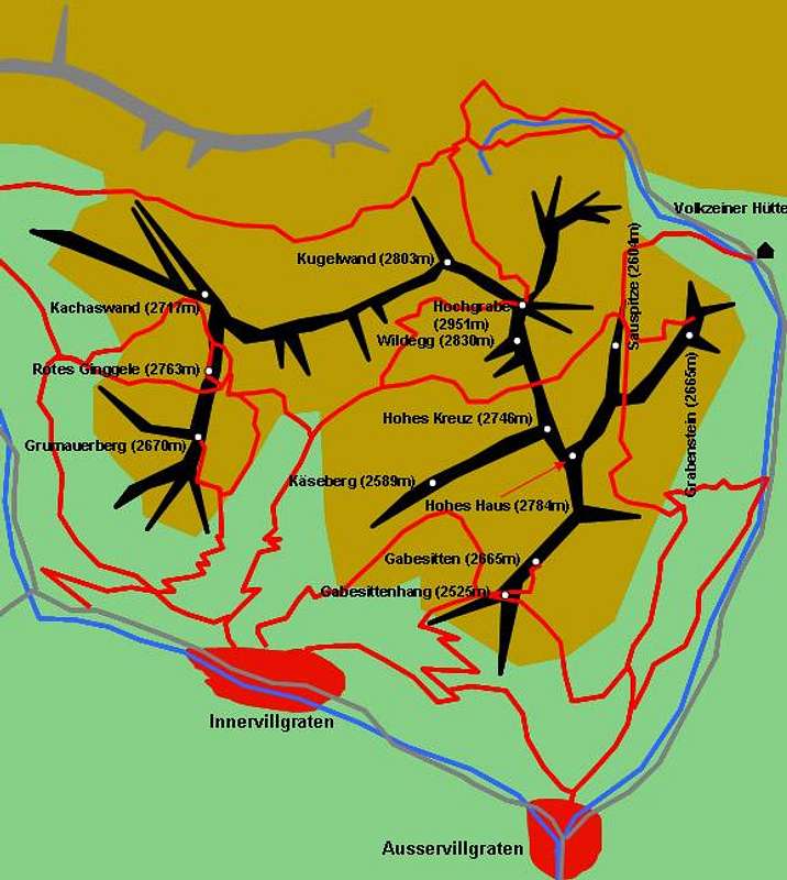
5 – Hochgrabe Group

The Hochgrabe Group, which is located south of the Villgraten Main Ridge in its highest part, is a little more complex than the other groups of the range. It is composed by three separate ridges which are connected across deep passes. The group is small and is located between the Villgraten and Winkeltal Valleys. Both valleys can be used as trailheads for the ascents of the mountains in this group.
Western Ridge
- Arntaler Lenke (2655m)
- Kugelwand (2803m)
- Kachaswand (2717m)
- Rotes Ginggele (2763m)
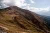
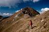
![Villgraten Group photo_id=128841]()
- Grumauerberg (2670m)

Central Ridge
- Hochgrabe (2951m)
See the Hochgrabe Page for more information.
![Villgraten Group photo_id=118411]()
![Villgraten Group photo_id=118442]()
![Villgraten Group photo_id=119638]()
![Villgraten Group photo_id=118608]()
![Villgraten Group photo_id=118433]()
- Wildegg (2830m)


Eastern Ridge
- Sauspitze (2604m)
![Villgraten Group photo_id=128890]()
- Grabenstein (2665m)
![Villgraten Group photo_id=128880]()
- Hohes Kreuz (2746m)
- Käseberg (2589m)
- Hohes Haus (2784m)
- Gabesitten (2665m)
- Gabesittenhang (2525m)


6 – Gölbner / Gumriaul Group
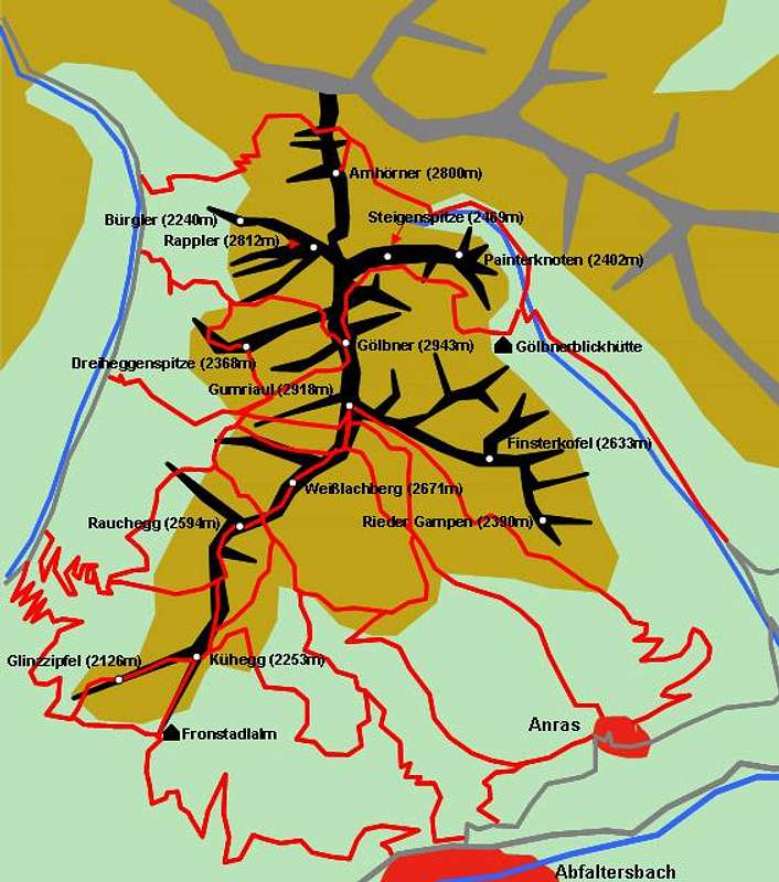
The Gölbner- Gumriaul Subgroup is wedged between the Winkeltal and Kristeinertal Valleys. It consists of a single ridge which splits at Gumriaul into two equally long sub-ridges. Lots of hiking trails cut through the subgroup, the popularity of which can be explained by easy access and by the great number of beautiful alpine lakes. Due to its southern location in the Villgraten Range the sumits command gorgeous views of the whole Dolomites.
Main Ridge
- Arnschartl (2632m)
- Arnhörner (2800m)
- Talletschartl
- Rappler (2812m)
![Villgraten Group photo_id=128879]()
- Bürgler (2240m)
- Steigenspitze (2469m)
- Painterknoten (2402m)
- Hohes Schartl (2669m)
- Gölbner (2943m)
![Villgraten Group photo_id=111281]()
![Villgraten Group photo_id=111283]()
![Villgraten Group photo_id=111282]()
- Dreiheggenspitze (2368m)
- Gumriaul (2918m)
See the Gumriaul Page for more information.
![Villgraten Group photo_id=111292]()
![Villgraten Group photo_id=111279]()
![Villgraten Group photo_id=111280]()


Western Ridge
- Weißlachberg (2671m)
- Kropfkarscharte (2459m)
- Rauchegg (2594m)
- Kühegg (2253m)
- Glinzzipfel (2126m)
Eastern Ridge
- Finsterkofel (2633m)
See the Finsterkofel Page for more information.
![Villgraten Group photo_id=119504]()
![Villgraten Group photo_id=111277]()
![Villgraten Group photo_id=119510]()
![Villgraten Group photo_id=119511]()
- Rieder Gampen (2390m)


Pastures
Besides the mountains this area is famous for its alpine pastures, which surround many small and very picturesque villages. In summer it is possible to rent small cabins for a holiday vacation in the heart of nature.Link: www.innervillgraten.info
 |
Winter Sport
There are three regions of cablecar skiing at the periphery of the Villgraten Group- Thurntaler at Sillian
- Brunnalm at St. Jakob in Defereggen
- Hochstein at Lienz
Cross-country skiing is popular in the Gsies Valley with a big competition each February .
The sport centre of Antholz / Anterselva is a world class location for the olympic sport of Biathlon, with a world cup event each January.
Ski Touring and Hiking
Ski TouringFor mountaineers ski touring (or snow shoeing) is the main option here. Recommendations for ski tours are almost endless. As there are no huts they have to be planned as daytrips from the valleys. Some possibilities are:
From Gsies / Casies Valley:
Hochkreuzspitze (2739 m), Riepenspitze (2775 m), Rotlahner (2748 m), Geil (2494 m), Körlspitze (2612 m), Gaishoerndl (2615 m), Hochhorn (2623 m), Amperspitze (2687 m), Hoher Mann (2593 m), Million (2438 m)
From Villgraten Valley:
Hochgrabe (2951m), Grosses Degenhorn (2946m), Riepenspitze (2775m), Rotes Ginggele (2763m), Kreuzspitze (2624m), Gaishoerndl (2615m)
Hiking
This is a mountain group for daytrips, for visiting pastures, lakes and easy summits.
Long-distance hiking trips are not that possible as elsewhere because there are no guided huts – except Volkzeiner hut – in the group. Doing a traverse with fine lodging in the valleys surely is an option - and for the hardcore hikers: why not use your bivuoac gear?
Camping is not restricted in the group. Just be sure to camp out high enough. Most of the lower slopes (below 2200 - 2300m) are used and belong to local farmers. If you want to camp that low, pay a call to them and they certainly will let you stay on their land.
Getting There
Most of the Villgraten Group is most easily reached from the south, from Pustertal / Val Pusteria. The Antholz / Anterselva, Gsies / Casies and Villgraten Valleys all run north from Pustertal and all lead into the heart of the group. The Derfereggen Valley in the north is equally suited as trailhead for any excursion into the group. The southern parts of Villgrater Berger can be reached from Pustertal directly.Western Approach
Take the Brenner / Brennero Motorway A22 from Innsbruck (north) or Verona (south). At Brixen / Bressanone turn onto SS49 into Pustertal / Val Pusteria. Depending on your preferred location turn north at Olang / Valdaora, Welsberg / Monguelfo or Sillian. At the Austrian - Italian border the road turns into B100. Here Anras, Assling and Lienz are reasonable trailheads for the group.
Northern Approach
Take B161, Felbertauern Road, from Kitzbühel south. After passing Felbertauern Tunnel you reach Matrei, where you can turn into Derfereggental Valley. If you go on, you'll reach Lienz, where you can turn west ino Pustertal Valley.
Eastern Approach
Take Motorway A2 from Klagenfurt to Villach. There turn onto A10 north which leads you to Spittal. A little north of Spittal turn west onto B100, which follows the Drau River Valley to Lienz and on into Pustertal Valley.
Southern Approach
Take motorway A27 from Venezia north to Belluno. At the end of the motorway take SS51 north to Cortina d'Ampezzo an on to Toblach/Dobbiaco. Here you are already in Pustertal Valley.
Accommodation
For accommodation follow one of the following links:- Hochpustertal official site
- Anras official site
- Sillian official site (click on the "Live Bilder" link for livecams and weather info).
- Außervillgraten official site
- Hochpustertal lodging (tiscover.at)
Mountain Huts and Refuges
Listed here are the refuges as well as the alms and farms where you can get food and lodging.| Refuge / Hut | Height | Open | Tel. |
| Hochstadelhaus | 1780m | mid June - end Sept. | +43 4710 2778 |
| Brunnalm | 2056m | n.a. | n.a. |
| Brugger Alm | 1818m | n.a. | n.a. |
| Mooseralm | 2345m | n.a. | n.a. |
| Volkzeiner Hütte | 2056m | mid May - mid Oct | +43 664 9888800 |
| Tessenberger Alm | 1950m | n.a. | +43 4842 62624 |
| Gölbnerblickhütte | 2025m | n.a. | +43 4846 6594 |
| Hochsteinhütte | 2023m | May - Oct, Dec - March | +43 664 3454960 |
| Taistner Sennhütte | 2012m | all year | +39 0474 944432 |
| Thurntalerrast | 1990m | n.a. | n.a. |
| Fronstadlalm | 1824m | n.a. | n.a. |
Red Tape
There is no red tape to be found in the group.Weather Conditions
Villgraten Group is located on the south side of the Alpine Main Ridge. In general this means that the weather is better than in the north of the main ridge. In winter the avalanche danger rating often is lower than in the northern or central parts of Tyrol. On the other hand it is possible that until January there is not enough snow for tour skiing.Weather Reports and Livecams:
- Tyrol weather
- Sillian official site (click on the "Live Bilder" link for livecams and weather info).
- Lienz City official site / weather
Avalanche reports:
Maps & Books
MapsI always use the maps by Kompass Verlag. They are scaled 1:50000 and show all the necessary informations. However, the Villgraten Group is located directly at the intersection of five of the maps, which is why it took me so long to prepare the schematic maps posted here.
- Lienzer Dolomiten / Lesachtal
1:50000
Kompass Map WK47
Kompass Verlag
ISBN: 3-85491-053-3
- Taufers - Ahrntal / Tures - Valle Aurina
1:50000
Kompass Map WK82
Kompass Verlag
ISBN: 3-87051-091-9
- Sextener Dolomiten / Dolomiti di Sesto
1:50000
Kompass Map WK58
Kompass Verlag
ISBN: 3-87051-065-X
- Bruneck - Toblach / Brunico - Dobbiaco
1:50000
Kompass Map WK57
Kompass Verlag
ISBN: 3-85491-064-9
- Defereggental-Lasörlinggruppe
1:50000
Kompass Map WK45
Kompass Verlag
ISBN: 3-85491-051-7
Books
Excellent hiking books are (German and Italian)
- Osttirol Süd / Tirolo Orientale Sud
W. Mair
Rother Verlag
ISBN: 3-7633-4132-3
ISBN: 3-7633-4307-5 (Italian)
- Osttirol Nord
H. Dumler
Rother Verlag
ISBN: 3-7633-4099-8
- Rother-Skifuehrer "Pustertal"
Rudolf and Sigrun Weiss
Rother Verlag, 2004
ISBN-3-7633-5911-7
Describes 50 ski touring trips in the area and the following ones in Villgraten Group: Rote Wand, Hinterbergkofel, Hoher Mann, Rotlahner, Hochhorn; Thurntaler, Hochrast, Marchkinkele, Pürgelesegungge, Kreuzspitze, Gabesitten
External Links
- Austrian Map online
Online digital maps of Austria (OEK 50, OEK 200 and OEK 500) by the BEV (Bundesamt für Eich- und Vermessungswesen) - in German