
-
 21987 Hits
-
 87.65% Score
-
 25 Votes
|
|
Mountain/Rock |
|---|---|
|
|
46.36784°N / 13.55412°E |
|
|
Hiking, Mountaineering, Trad Climbing, Ice Climbing, Scrambling, Skiing |
|
|
Spring, Summer, Fall, Winter |
|
|
7244 ft / 2208 m |
|
|
Intro
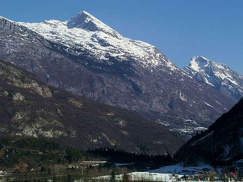
Rombon from the SW
What's new here?
> September 12th, 2017: WW1 chapter updated> July 1st, 2017: Geological note.
> April 1st, 2012: SP V3 design applied.
> March 26th, 2006: Initial page created.
Overview
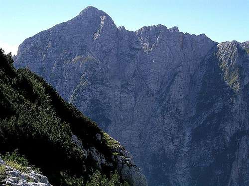
North face

The summit part (from the SW)

Rombon gets presented
Rombon, its peak is called also Veliki vrh, is the highest elevation in a side ridge, going from Kanin/Canin group main ridge towards the South-East. Thus, the whole massif is on the Slovenian territory. Even if it is a part of the massive Kanin/Canin group, the summit is from many sides seen as a fine, self-standing peak. That's why it also offers a great panorama on all sides. On the southern side, just below the summit of Rombon, there's Bovec, the only real town in the upper Soča valley. But it's altitude is only 460 m, so by the shortest route you need to overcome for the ascent on Rombon more than 1700 m. As Bovec lies on the Northern side of a small plane, where Soča river makes a wide turn, Rombon summit is seen from many places in the valley. These southern slopes are covered with beech woods below, grassy above and considerably intermitted with steep rocks.On the northern side the beautiful Možnica valley divides Rombon massif from the main ridge and the side ridge of Jerebica. Also Možnica is deeply cut into mountains body, its meadows lie on the altitude of some 800 m. Like the majority of mountains in Julian Alps, also Rombon has a steep, on some places almost vertical northern face, allowing also some harder climbs. The long northern wall from Rombon summit to the summit of Vrh Ribežnov is beautifully seen from Log pod Mangartom village and of course from Možnica valley.
As said, Rombon forms a small massif, but peaks other than the main one are more or less unimportant. The majority of them is rising from the main crest of Rombon (Vrh Ribežnov, 2022 m, Prišna glava, 1946 m, Malo and Veliko Ušje, 2048 m). From the summit of Rombon, the main ridge falls steeply down, forming just above Koritnica valley a few minor bumps (Kanja, Kucer, Na Robu). From the main summit towards the SW a side ridge goes, which also lowers soon, finally forming a distinct bump, called Čuklja, 1767 m. We shall tell more about it later. West of the main summit, towards the main ridge of Kanin/Canin massif, a broad karst plateau is stretching. This is one of the most amazing places in Julian Alps. Its limestone is like a Swiss cheese, all water disappears immediately underground, so no wonder that in last decades some of the deepest caves in Europe were discovered here.
The ascent on Rombon is not hard, it's more or less only a strenuous walk-up by paths, marked or unmarked. The summit ridge is rocky, that's why Rombon is not a usual goal for tour skiing. Skiing can in good conditions be done from the very summit, but requires a perfect mastery of technique and good nerves on a few expposed passages. From the summit you have a great panorama on the whole wreath of mountains, encircling the beautiful Bovec cauldron.
Geological outline
Rombon's geology is quite simple. Almost the whole massif is built of dachstein limestone from the upper triassic period. As elsewhere in the massif of Kanin, these thick layers of limestone are lying on a bit older layers of main dolomite. On Rombon, these are coming on the surface only on the slopes above Možnica valley. And that's more or less all, because for us it's less important that just above the valley near Bovec some jurassic and cretacious rocks can be found. From the NE From the NE |  Bor - From the NW Bor - From the NW |
Other Places To See

Možnica waterfall
2. Cemetery from the World War I. East of Bovec, on the crossroads into Koritnica valley.
3. Kluže fortresses. The lower and the upper fortress (Fort Hermann), by the road into Koritnica valley.
4. Možnica waterfalls. A nice hike by unmarked paths, not all the time easy, visits some nice waterfalls and cascades.
A Heaven For Speleologists
Erosion and tectonic moves created in Kanin massif many very deep and long caves. The depth potential of the massif is over 1800 m, which creates some possibilities to get even deeper as explorers came today. Each year, mostly in dry seasons, in these caves expeditions of the best speleologists of the world arrive.The deepest cave on the Kanin-Rombon plateau is Čehi 2. Its depth is 1502 m, the entrance was discovered in 1991 by Czech, Italians came till 1993 1370 m deep and almost 4000 m into the massif of Rombon. In 1999 Ucrainian speleologists in a 14-days expedition discovered a new perplexus of tunnels, which lead them down on 1380 m of depth. Finally on December 29th, 2003 Slovenian speleologists reached the lowest point on the depth of 1502 m.
Here's the list of some famous caves in Rombon massif (source):
1. Čehi-2, 5291 m long, 1502 m deep.
2. Črnelsko brezno, 11450 m long, 1241 m deep.
3. Vandima, 2500 m long, 1182 m deep.
4. Brezno Hudi Vršič, 737 m long, 620 m deep.
The World War I On Rombon
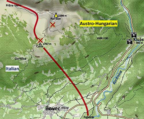
The frontline during most of the WW1
The most severe fightings were for the small Čukla (Čuklja) summit and, also for the summit of Rombon itself. The italians were building the whole infrastructure by communication lines (including material cableway) up from Bovec on the S and from Černela on the NW, while Austrians were supplying to the frontline from Kluže (also with a material cableway) on the E. A short outline of events is below:
1915, May: Italians take broad areas of Kanin massif.
1915, August 27: Italians attack Rombon, taking Čukla, retreating on the summit ridge (2105 m).
1915, September 12: Second Italian attack on the summit of Rombon unsuccessful.
1916, February 12: Austrians re-take Čukla.
1916, February, March: Italians unsuccessfully attempt to re-take Čukla.
1916, March: Austrians try to push forward, but unsuccessfully.
1916, May: Big Italian attack, they re-take Čukla again. Big losses on both sides.
1916-1917: Position war.
1917, October 24: Start of the big Austro-German attack along the whole Soča frontline.
1917, October: Austrian attacks on Čukla again unsuccessful.
1917, October end: Italian frontline collapses. They retreat westwards to the Piave river.
Getting There
See the Julian Alps overview page and the Kanin Group page!By car/bus Soca valley and Bovec can be reached over Vršič pass (from Sava valley), over Predel/Predil pass (from Tarvisio) or from the south, from Gorica/Gorizia. Soča valley can be from Italy also reached from Udine via Tarcento.
For one of the routes you can also use the Kanin cable-car: It goes up - from 7:00 to 15:00 (each full hour) and down - from 8:00 to 16:00 (each full hour). pictures
Mountaineering Map: Julijske Alpe - Zahodni del (Western part). Planinska zveza Slovenije. 1:50000.
Routes Overview
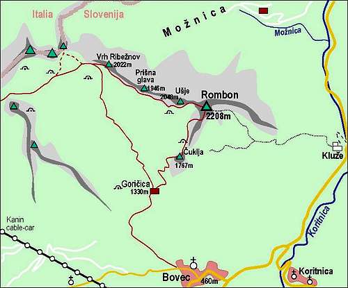
Rombon and its routes
1. South-West Route
You start in Bovec town and ascend through the woods on Goričica meadow. During the World War I this was the main supply route for the Italian positions on Ćuklja and higher, so all around there are many remains from the war. The today's marked path however goes mostly through the woods. From Goričica you continue further towards the north on Čuklja and then west of the south ridge till the broad, steep rocky ravine, which brings you right on the summit ridge. Then by it in a few minutes on top. 1750 m, 5:30 h. Marked walk-up, some rocks on the top. By the Swiss Hiking Scale the ascent difficulty would be rated T2/T3. Hot in summer! From Čuklja to the summit we can also follow a steeper route, which goes all the time by the South ridge. It's harder and has some steel ropes to secure passages.2. West Route
You start the tour from the upper station of Kanin cable-car, on 2200 m. Over the notch below Prestreljenik, 2282 m, you descend on Prevala pass, 2067 m, and then continue over the southern slopes of the main ridge to Vrh Ribežnov notch (speleological bivouac!). Near Vrh Ribežnov the marked path turns towards the SE and goes over the southern slopes of Rombon ridge. The terrain is more a high plateau, so the path goes a bit left and right and also up an down. Also on this route we can visit many ex Italian positions from the war. When the path approaches the summit of Rombon, it ascends steeply on the northern edge abov Možnica valley and over the rocks soon gains the summit of Rombon. Marked path, only the summit part rocky (scramble), T3 by the SAC Hiking Scale. 3:30 h to 4:00 h. It is best to descend into Bovec by the route #1 and then go to the lower station of cable car, where we probably have our car.3. South-East Route
You start at Kluže fortress, on the main road. First you go up to the higher fortress, and then continue in a western direction by abandoned military paths. Between Krljišče, 1753 m and Kucer, 1638 m, you turn right (northwards), ascend the upper part of the mountain and continue towards the NW till the highest point. Marked, still some orientation skills needed. As I have not done the route, I will not rate its difficulty. 1700 m of ascent, 5:00 h. If behind Kucer you stick to the East ridge, you can reach the summit in an easy climb.When To Climb?
Rombon can be best climbed in late spring and in autumn. Summer is of course possible too, but the tours can be very hot. For tour skiing other goals in the Kanin/Canin group are more appropriate (but also Rombon is possible). Also classical winter ascents are possible but you will need a winter equipment (crampons, ice-pick) and you should have in mind a big altitude difference.For weather, see the wunderground site - here's the direct link to Kredarica station, 2515 m (below Triglav summit).
Red Tape
No limitations.Huts And Camping
On the mountain there are no opened mountain huts. Camping is officially not allowed, but is tolerated for speleological expeditions. For mountaineering nobody will bother you if you set up a tent just over the night. Otherwise you can find accomodation in Bovec, which is developing into one of our most attractive tourist destinations. The main attraction of it is Soča river, of course.Speleologists have arranged a bivouac on the main ridge, near Vrh Ribežnov, 2022 m.