Overview
![Preber from Tamsweg]() Preber from the south
Preber from the south![Kasereck from Preber]() Kasereck from Preber
Kasereck from PreberIf there is an
ideal mountain for tour skiing, then Preber should qualify. All right, its ski slopes are oriented towards the south, but its considerable heigth assures good conditions long into spring season. In a few words - you step out of your car on 1500 meters, put your skis on, walk up almost 1250 meters and ski down by all the times equally inclined slopes. Due to its many easy and marked paths the mountain is popular also in summer, but definitely it stays in the memory of mountaineers as a typical ski mountain.
Rising close to the highest part of Niedere Tauern, Preber's trails by its altitude Hochgolling, the highest suimmit, for only 123 m. But Preber's nature is much different. It has steep, rocky slopes towards the north and north-east, but its most distinct feature is the long south-east ridge, from which gentle slopes are falling towards the south and south-west. From the fore-summit another gentle shoulder is descending towards the south, offering ideal ski slopes. That's where you can choose slopes, oriented more towards the SE, S or SW. The western slopes of Preber are again more steep and partially also rocky.
As other mountains in this area, also Preber is delimited from the neighbouring mountains by long, flat valleys, reaching from the main valley of river Mur deep into the main massif.
To the north-west of Preber the neighbouring summit of
Roteck stands. It is even 2 meters higher than Preber, but, at least in winter and spring, far less frequented. Over it Preber attaches to the main spine of Niedere Tauern mountains.
Summit View
![Preber Panorama]() N-E view
N-E viewBeing one of the highest mountains of Niedere Tauern, Preber offers a very broad panorama. For me, standing on its top in a perfect day, the most impressive was the view to the rest of Niedere tauern towards the NE and E. I am again and again impressed by so many waves of 'nameless' mountains, as you can see them from Hochgolling, Greifenberg or Preber. It looks like a see after a storm. Very nice is also the view on Hochgolling itself and on the sharp Kasereck in its south ridge. Towards the SW you will enjoy the view on glaciers of Hohe Tauern, especially on Hochalmspitze and Ankogel. The whole southern horizon is filled with gentle Gurktal Alps / Nockberge and behind them my heart of course welcomes my home Julian Alps, Karavanke and Kamnik Alps. Nice is also the view down into the broad and sunny valley of river Mur.
![Dachstein South-face from Preber]() Dachstein Dachstein | ![Preber View]() E view E view | ![Hochgolling from Preber]() Hochgolling Hochgolling |
Getting There
![Niedere Tauern interactive...]() Niedere Tauern Niedere Tauern |
For the overall orientation, see the
Niedere Tauern Group page!
![Murau]() Murau town
Murau town![Near Preber See]() Near Preber See
Near Preber SeeActually all normal approaches to Preber are coming from the south. Even if you would attempt an ascent from the north, you would need to enter one of the side valleys from Mur valley, so from the southern side.
You best reach the valley of Mur by the Villach - Salzburg highway, exit St. Michael. From there drive towards the east along Mur till
Tamsweg. The other approach direction is from the east, if you come, for example by Pyhrn highway and drive up the river Mur valley towards the west till Tamsweg. Tamsweg has also a railway connection.
In Tamsweg you take the road towards the NE, which brings you to
Prebersee (Preber Lake), 1514 m. There is the trailhead of the shortest and most obvious approach route. The trailheads in/above Oberdorf (in Lessachtal) and in the valley of Feister Bach are a bit more remote. You can reach Preber See also by a bus, which drives there from Tamsweg.
Routes Overview
![Preber Map]() A self-made map of Preber and its marked paths
A self-made map of Preber and its marked paths![Preber Ski Ascent]() Ski ascent from the south
Ski ascent from the south1. South slopes.
From Prebersee, 1514 m, take the marked path towards the N to Preberhalterhuette, 1862 m, and further towards the N directly on top of the fore-summit and further on the main summit. 3 h 30 min, easy hike-up. Also the most popular ski tour.
2. South-east ridge.
From the saddle east of Preber See ascend towards the NE Grazer Huette, 1896 m, then follow the main ridge towards the NW all the way to the top. 3 h 30 min, easy hike-up.
3. From Lessachtal.
From Unterdorf or Oberdorf, 1198 m, a mountain road brings you towards the NE on Wagenberg, 1402 m. From there follow the marked path towards the N, and over the slopes of Golzalm towards the E into Preberkessel. By the valley you can reach towards the N the saddle, named Muehlbachtoerl, and from it both highest summits: Roteck and Preber. From the lower part of Preberkessel you can also cross further towards the East and reach Preber's south slopes. There go on top as described in #1.
You can see a detailed map (1:50000) on-line on:
http://www.austrianmap.at/.
Red Tape
For the summit ascent there are no limitations. Otherwise the area is protected as the Niedere Tauern National Parc.
When To Climb?
![Beautiful autumn colors]() Autumn
Autumn![Prebersee]() Prebersee impression
Prebersee impressionIn summer the best months are June to October. For skiing, you can find good conditions also in winter (take care in case of low visibility or very deep snow!), but the best season is somewhere from February till April.
As only the highest part of the ascent is a bit steeper, Preber can be virtually ascended in any season, appropriate equipment provided, of course.
Mountain Huts And Camping
![Preberhalterhuette]() Preberhalterhuette
PreberhalterhuetteIn Tamsweg there is a camping place and in the town and its surroundings there are many tourist facilities. For the ascent itself you don't need to sleep on the mountain.
On the SE ridge there stands the official mountain hut, called Grazer Huette, 1896 m. It can be rached from the road east of Preber See by a marked path (or a mountain road - using a bike) in 1 hour. The hut has 25 beds and is opened from begin of June till end of September. Telephones - Hut: +43/650/7845693, in the valley: +43/6476/512, Mobile: +43/650/7845693. Web address:
www.grazer-huette.at.
Mountain Conditions
For weather conditions for Austria see
here (then choose regions: Salzburg, Steiermark and Kaernten).
Here is the avalanche info page for
Steiermark.

 12086 Hits
 89.01% Score
 28 Votes
 Preber from the south
 Kasereck from Preber
 N-E view
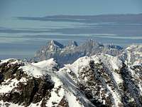 Dachstein
 E view
 Hochgolling
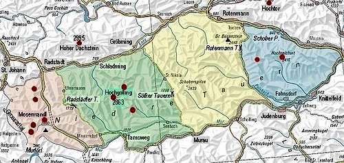 Niedere Tauern
 Murau town
 Near Preber See
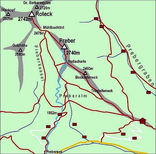 A self-made map of Preber and its marked paths
 Ski ascent from the south
 Autumn
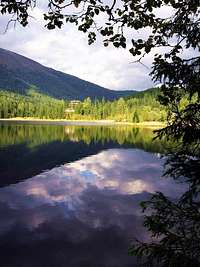 Prebersee impression
 Preberhalterhuette