
-
 9090 Hits
-
 85.36% Score
-
 20 Votes
|
|
Mountain/Rock |
|---|---|
|
|
38.90440°N / 104.9891°W |
|
|
El Paso |
|
|
Hiking |
|
|
Spring, Summer, Fall, Winter |
|
|
9076 ft / 2766 m |
|
|
Overview
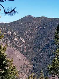
Five and ½ miles northeast of Pikes Peak, Mount Heizer looks over thousands of visitors to the Pikes Peak Highway each year . En route to the summit of Pikes Peak via the toll road, some may stop at the Crow Gulch Picnic area for a rest and a snack and maybe even to scramble on the boulders on Heizer’s southwestern face. Only a relatively small number of these may forge on to the summit of Mount Heizer. Pikes Peak from Mount Heizer Summit
24 Jan 09
Missing status as a ranked Colorado summit by a mere four feet, Mount Heizer provides a short, convenient day outing for residents of and visitors to the Colorado Springs metropolitan area. The in-your-face views of Pikes Peak are sure to delight, while Almagre shines in the sun below his domineering neighbor.
Colorado Rank: Unranked
Prominence: 296 feet
Mountain Range: Front Range
USGS Quad: Cascade
Trails Illustrated Map: #137 (Pikes Peak, Cañon City)
Rank and Prominence Reference: Lists of John
Getting There
Mount Heizer rises mid-way between the Ute Pass / Hwy 24 communities of Cascade and Chipita Park. These communities are western exurbs of Colorado Springs. The mountain sits in western El Paso County, not far from the border with Teller County.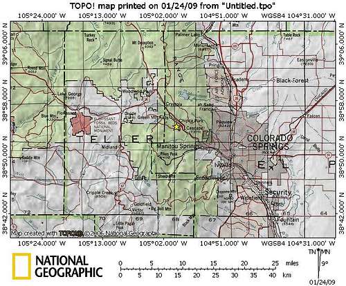 Click on image to enlarge
Route Overview
| Route | Approximate Mileage | Approximate Elevation Gain | Special Note | Driving Directions |
|---|---|---|---|---|
| Crow Gulch Indirect | 1.5 miles roundtrip | 400 ft. | Easier on the mountain and the knees than Direct option | Take Highway 24 to Cascade, Colorado. Follow the signs to Pikes Peak Highway, heading west at the traffic light. Crow Gulch parking is before mile marker 3 on your right. |
| Crow Gulch Direct | Less than 1 mile roundtrip | 400 ft. | Steep but quick option; faint trail and route finding | Take Highway 24 to Cascade, Colorado. Follow the signs to Pikes Peak Highway, heading west at the traffic light. Crow Gulch parking is before mile marker 3 on your right. |
| From Chipita Park | 2 miles roundtrip | 1,200 ft. | Steep climb from the Hwy 24 corridor; more challenging but also more traffic noise | Exit Hwy 24 at Chipita Park; west to Mountain Road to Mt. Esther Trail trailhead. |
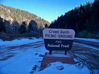 Grow Gulch Picnic Grounds
17 Jan 09
 About the Crow Family, Crow Gulch Namesake
17 Jan 09
Red Tape
If accessing Mount Heizer from the Pikes Peak Tollway, usage fees and curfews apply.Curfew: Generally speaking, the gates at the tollbooth close at 7:00 PM in the summer and 5:00 PM in the winter. Check the Pikes Peak Highway Website or call 719-385-Peak to check when the gates will be closed for the day you plan to visit.
Fees: As of this writing, the fee for the Toll Road is $10.00 per adult (16 and over $5.00 per child (6 - 15) or total $35.00 per car. Cash and credit cards (Visa and Master Card) are accepted. However, if you are not going to the top of the mountain, let the gate attendant know. A special rate of $4.00 per adult is available for visitors going only as far as Crow Gulch. Be honest and do not take advantage of this special program.
Camping & Lodging
CAMPINGThe area surrounding Mount Heizer is built up to the extent that backcountry camping is not an option. Neither of the primary trailheads (Crow Gulch and Mount Esther in Chipita Park) offer camping.
The nearest US Forest Service campsites would be in the Rampart Reservoir area. Be forewarned that the proximity of this area to the urban I-25 corridor means that crowding can be an issue, especially in the summer, and that unsavory characters are known to frequent this area. Be prepared for heavy ATV use, large crowds, drunkenness and casual firearms usage.
 View from Mount Heizer's Southeast Summit
24 Jan 09
 Looking across Ute Pass from Mount Heizer
24 Jan 09
Meadow Ridge Campground:
- 19 campsites
- 9,200 feet elevation
- Season: Generally early May through September
- $15 per night, per site
- Amenities include tables, fire grates, drinking water, latrines, and trash collection
Thunder Ridge Campground:
- 21 campsites
- 9,200 feet elevation
- Season: Generally early May through September
- $15 per night, per site
- Amenities include tables, fire grates, drinking water, latrines, and trash collection
HOTELS
Cascade is about mid-way between Colorado Springs and Woodland Park on Hwy 24 (Ute Pass).
Woodland Park
A few simple hotels (many family-run) are available in Woodland Park (elevation 8,465 feet) along with several RV sites and cabins. For more information visit The Greater Woodland Park Chamber of Commerce Visitor Information page.
Manitou Springs
Manitou Springs lies at the foot of Ute Pass. This colorful, eclectic town offers a wide range of lodging options including old-style motor cottages and cabins, retro family-run motels, charming B&Bs and modern chain hotels. Shopping and dining are within walking distance of most Manitou lodging.
Colorado Springs
The hotel options in Colorado Springs are virtually limitless. If you are the 5-star luxury type, be sure to check out The Broadmoor.
 |
 |
 |
Click on images to enlarge.
Weather & Seasons
Due to relatively low altitude, Mount Heizer is a reasonable year-round summit objective.Winter: Typically, this would be a very pleasant hike, free from crowds, in the winter. However, heavy winter snows would close the Pikes Peak Toll Road and make the route from Chipita Park cumbersome.
Summer: The crowds using the Pikes Peak Toll Road could be overbearing in the summer months.