Overview
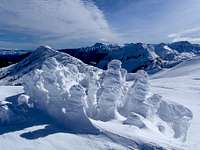
| ![North Chiwaukum]() The Summit, February 2010 The Summit, February 2010 | |
North Chiwaukum is one of the northern most points along a six mile ridge running north-south which make up the Chiwaukums. There are roughly twenty other distinct high points along the ridge including Middle Chiwaukum and Big Chiwaukum. The standard approach for the larger
Middle Chiwaukum passes either by North Chiwaukum or over the top of it. Many backcountry hikers underestimate the challenge of neighboring Middle Chiwaukum and therefor settle for a summit of North Chiwaukum instead. Although somewhat of a consolation prize for people who intended to climb Middle Chiwaukum, the view and sense of accomplishment found on the summit should not be underestimated.
| ![North and Middle Chiwaukum Panorama]() North Chiwaukum and Middle Chiwaukum, Photograph by Josh Lewis North Chiwaukum and Middle Chiwaukum, Photograph by Josh Lewis | |
Are you wondering yet how many times one can use the word Chiwaukum? A few more I think. According to Paul Klenke's research, Chiwaukum is a Native American word meaning “place where many streams come together.” Klenke on his page for
Big Chiwaukum also mentions that this subrange is comprised primarily of schist.
Getting There
On the south side of Highway 2 (eastbound) look for a road called WhitePine roughly 30 miles from Leavenworth and 25 from Stevens Pass. Take the road for 4 miles to the Whitepine trailhead where a sign board stands. You will pass under a bridge along the way. In summer parking at the trailhead requires a Northwest Forest Pass. There are several private residence along this road so it should be plowed year-round to at least 1.75 miles from the trailhead. In winter it may be necessary to walk the 1.75 miles to the sign board. If driving in winter, keep in mind you may need traction devices for your tires.
The Route
| ![Sloan and Glacier Peak]() Looking Down the Northwest Ridge Looking Down the Northwest Ridge | |
From the Whitepine trailhead cut immediately off the road and into the trees on a bearing of south by southwest. This steep ascending traverse will soon take you to the top of the northwest ridge. Don't expect much of a view until you reach the upper meadows. Follow the ridge straight up for 3000 vertical feet. When the grade eases up you will periodically break out of the trees, and if the weather permits, have a view of the summit. Continue to follow the ridge. Higher up you will also catch a view of the impressive north face of Middle Chiwaukum. Watch for avalanche danger in winter. Remember that most human triggered slides happen on slopes ranging between 35 and 45 degrees.
External Links

 10895 Hits
 85.36% Score
 20 Votes

 The Summit, February 2010

 North Chiwaukum and Middle Chiwaukum, Photograph by Josh Lewis

 Looking Down the Northwest Ridge