


-
 3667 Hits
-
 82.48% Score
-
 15 Votes
|
|
Mountain/Rock |
|---|---|
|
|
45.84910°N / 7.09599°E |
|
|
Hiking, Mountaineering |
|
|
Summer, Fall |
|
|
10128 ft / 3087 m |
|
|
Note
La montagna chiama i suoi figli, ed essi rispondono fedelmente al suo appello… Osvaldo Cardellina, Diario alpinistico, 1964-65 Page texts: @ OsvaldoCardellina "Osva", passed away on May 2, 2022. Page owners: Christian Cardellina e Osvaldo Cardellina. Any updates from September 12, 2022: Antonio Giani, page administrator, friend and climbing companion. Testi della pagina: @ OsvaldoCardellina "Osva", scomparso il 2 maggio 2022. Proprietari pagina: Christian Cardellina e Osvaldo Cardellina. Eventuali aggiornamenti dal 12 settembre 2022: Antonio Giani, amministratore della pagina, amico e compagno di salite. |
Overview
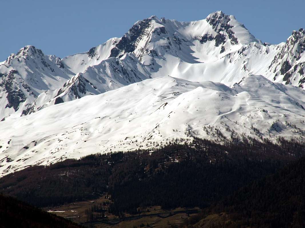
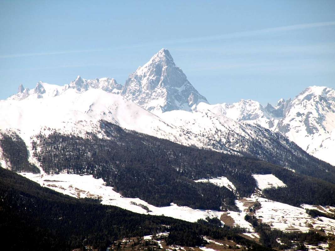
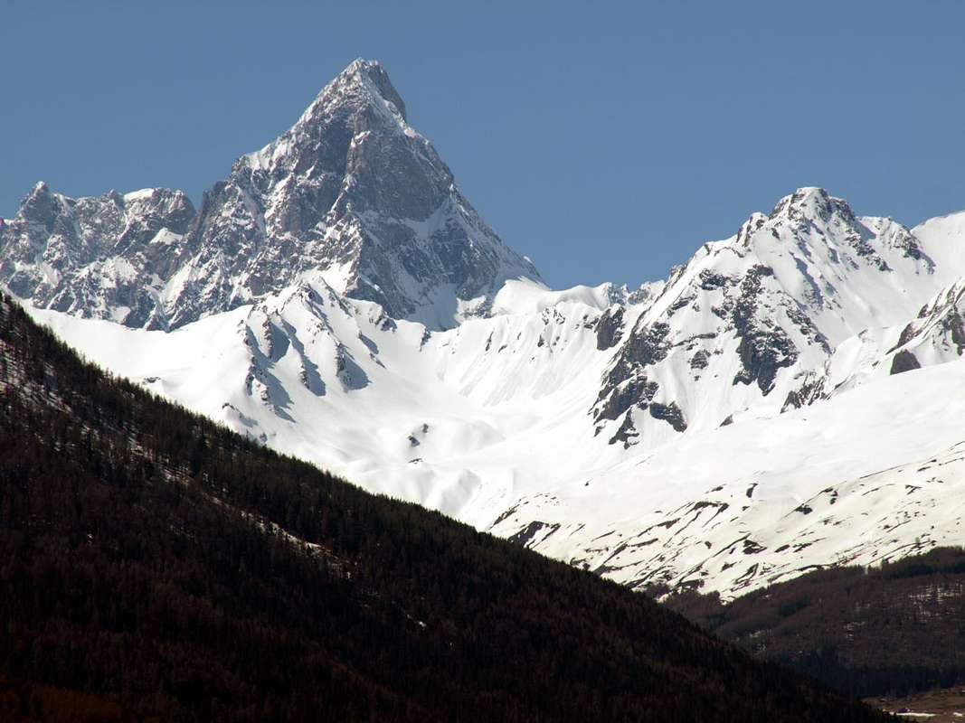
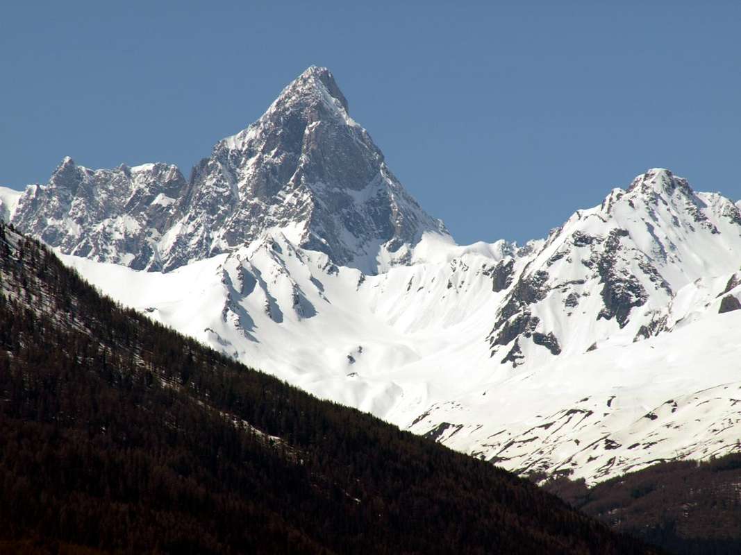
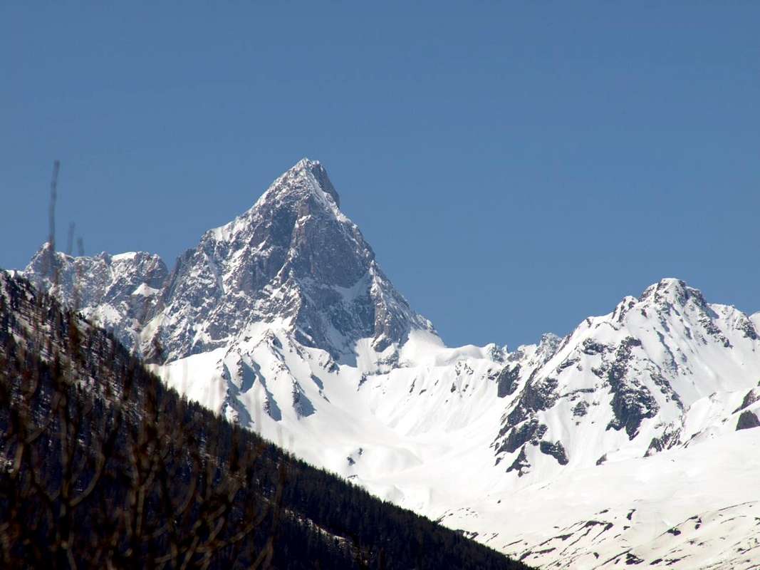
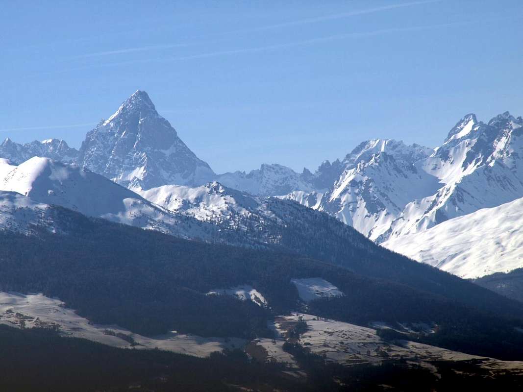
We continue the search for mountains that that are not well known and even less busy. Although this certainly appears to be a mountain little known and even less visited. Even the Aiguille de Bellecombe (3.087m), on Golliats Group does not record an excessive number of ascents, despite the lure tied to the name, perhaps the most famous in the past at the time of the Mountaineering Classic, and the relatively middle-high altitude. Then imagine for these satellites supporting actors that are certainly not comparable for example to those of Mont Blanc de Tacul. There we rock sound and compact, but here we find it somewhat broken, if not in decay. So there? Is to be not expected much for climbing, while the sense of a visit is the search for "exploratory", for those who still love it. Just from Grand Golliaz a short ridge, almost straight down linearly towards the South reaching the near Petit Golliaz, just a few feet lower (3.234m). From this last the same splits sending a branch towards South-southwest, act to separate the higher, or Northwestern, the Combe du Merdeux from Vallon of Bellecombe into the adjacent Italian Val Ferret (above Courmayeur Resort). The other branch is directed instead toward Southeast reaching the Col de Saulié (2.817m), located between the first basin and that of Thoula and to the foot of the Eastern Slope of Grand Golliaz. Toponymically Bellecombe derived from "Beautiful Comba" or little an tini valley or circular basin, with a place name that is not rare in Aosta Valley. Typical of an especially graceful as homonyms lakes in the Valley of La Thuile, or in a particular location (eg for the minerals) at Monte Barbeston immediately above the Municipality of Pontey. Due to the fact that the median part of the valley is marked by a series of water emersion between Col St. Rhémy and the long ridge that down by Aig. de Saulié to Southeast. Topographically speaking to note that this pyramidal mountain, collocated on the axis between South and North, is formed by three ridges with many slopes. Two ridges disembarking in South-southwest and North reaching the a carving 2.877 meters, before of the Mont du Tapier and Malatrà Hill (3.014m, 2.928m), and Bellecombe Pass (2.906m) towards the nearby Petit Golliat. The third or Southeast divided into two parts (the North-northeast and the Southwest) on the Eastern Slope above the Comba du Merdeux. The whole is made up of rocks of calcium schists and brittle with very broken rotten slabs. These factors, coupled with the fact of being hidden from the greater consistency of the two neighbors Golliazs, make that this small rocky pyramid, along the lines to the South next to the Aiguilles of Artanavaz, Malatrà and Bonalé, is to be little known and equally few visitors. We have to "wait" the Grande Rochère (3.326m), above Planavalle, to "recover" a Summit in evidence and comparable to Grand Golliat (3.337m). In Mountaineering terms to be reported as all Summit are rarely frequented, especially the Aiguille de Bellecombe that is typically achieved from the adjacent Val Ferret. This as for the adjacent Petit Golliaz (3.234m), both within the Western side to the East-southeast from Arnouva or Arp Nouva (1.769m) through the Vallon of Bellecombe. A climb that has common origins both in the approach to the climb that takes place from Bellecombe Colle or Saddle (2.906m), located between Vallon Bellecombe and Comba du Merdeux. Actually even more than a saddle or a pass is a small but pronounced slotted between the Val Ferret and the Valley of the opposed Great St. Bernard. This is because the Northern Ridge with its unevenness and asperities appears more difficult than it is, but mainly because those coming from the Valley of the Great St. Bernard turns his attentions mainly to the Grand Golliat/Golliaz, albeit slightly higher but better in view looking mainly from North or Switzerland. Still on the Petit Golliaz be noted that the Ridge Southwest from Bellecombe Pass knows a good attendance, while the parallel crest or Southeast to the Col de Saulié is probably a one time been traveled. Panoramically Photographically speaking to observe the great exposure for all ridges, while the walls-faces, as well as dangerous, are very "closed" in regard. Great views of the Mont Blanc Chain with the Grandes Jorasses in front and up to Dolent-Tour Noir, while in the North they begin the Pennine Alps with Mont Velan and Grand Combin on the famous Great St Bernard Pass, fully visible from here. In the South they completely relax the Alps Graian from Rutor until the Monte Avìc on the valley floor.
Continuiamo la ricerca di montagne che non siano molto conosciute e frequentate. Anche questa sicuramente risulta esserne una poco conosciuta ed ancora meno frequentata. Anche questa Aiguille de Bellecombe (3.087 m), nel Gruppo dei Golliazs non registra un eccessivo numero d'ascensioni, nonostante il richiamo legato al nome, forse più famoso nel passato ai tempi dell'Alpinismo Classico, ed all'altitudine relativamente elevata. Immaginiamo quindi per questi satelliti comprimari, che non sono certamente paragonabili ad esempio a quelli del Mont Blanc de Tacul; lì abbiamo roccia sana e compatta, qui invece la troviamo alquanto rotta, se non addirittura in disfacimento. Quindi non c'é da attendersi molto per l'arrampicata, mentre il senso di una visita consiste nella ricerca "esplorativa", per coloro che ancora la amano. Proprio dal Grand Golliaz una breve cresta, quasi rettilinea, scende verso Mezzogiorno raggiungendo il vicino Petit Golliaz, di appena qualche metro più basso (3.234 m). Da questo la medesima si sdoppia inviando un ramo vero Sud-sudovest, atto a separare la parte più elevata, o Nordoccidentale, della Combe du Merdeux dal Vallone di Bellecombe internamente alla Val Ferret. L'altro ramo s'indirizza invece al Sudest raggiungendo il Col de Saulié (2.817 m), a cavallo tra la prima comba e quella di Thoula ai piedi del Versante Orientale del Grand Golliaz. Toponomasticamente deriva dalla sottostante ed omonima comba da "Bella Comba" ovvero piccola e graziosa vallata, con toponimo facilmente riscontrabile in Val d'Aosta. Tipico d'un luogo particolarmente leggiadro come per gli omonimi laghi a La Thuile, oppure d'una località particolare (ad esempio per i minerali) presso il Barbeston. Topograficamente da annotare che questa montagna piramidale, collocata sull'asse tra Sud e Settentrione, risulta formata da tre creste con altrettanti versanti. Due creste scendono rispettivamente a Sud-sudovest e Nord raggiungendo l'intaglio 2.877 metri, prima del Mont du Tapier e del Col Malatrà (3.014 m, 2.928 m), ed il Colle di Bellecombe (2.906 m) fungendo da "trait d'union" col vicino Petit Golliaz. La terza o Sudest divide in due parti (Nord-nordest e Sudovest) il versante Orientale sopra la Comba du Merdeux. Il tutto risulta formato da friabili rocce calcescistiche con lastroni molto rotti. Fattori questi che, insieme al fatto di essere nascosta dalla massa prorompente dei due vicini Golliazs, fanno si che questa piccola piramide rocciosa, sulla falsariga delle successive a Meridione Aiguille di Artanavaz, Malatrà e Bonalé, venga ad essere poco conosciuta ed altrettanto scarsamente frequentata. Bisogna "attendere" la Grande Rochère (3.326 m) per "ritrovare" una Cima in grande evidenza e paragonabile al Grand Golliaz (3.337 m). Alpinisticamente da segnalare come tutte sian assai raramente frequentate, soprattutto l'Aiguille de Bellecombe; generalmente é raggiunta dalla Val Ferret italiana. Questo come per l'adiacente Petit Golliaz (3.234 m), entrambi raggiungibili dal lato Occidentale con partenza da Arnouva o Arp Nouva (1.769 m) tramite il Vallone di Bellecombe. Una salita che ha origini comuni sia nell'approccio che nella salita che avviene dal Colle o Sella di Bellecombe (2.906 m), posto tra la Val Ferret e la Comba du Merdeux. Questo perché la Cresta Nord con le sue asperità appare più difficile di quanto non sia, ma soprattutto perché chi proviene dalla Valle del Gran San Bernardo rivolge l'attenzione principalmente al Grand Golliaz, anche se di poco più elevato ma maggiormente in vista guardando soprattutto dalla Svizzera. Sempre a riguardo del Petit Golliaz da notarsi come la Cresta Sudovest dal Colle di Bellecombe conosca discreta frequentazione, mentre la parellela o Sudest verso il Col de Saulié probabilmente é stata percorsa in un'unica volta. Panoramicamente e Fotograficamente da osservare la grande esposizione per ogni cresta, mentre le pareti, oltre che pericolose, son assai "chiuse" al riguardo. Grandiose vedute sulla Catena del Monte Bianco con le Grandes Jorasses in fronte e fino al Dolent-Tour Noir, mentre a Settentrione iniziano le Alpi Pennine con Mont velan e Grand Combin sopra il famoso Colle del Gran San Bernardo, da qui pienamente visibile. A Meridione si distendono completamente le Graie dal Rutor fino all'Avìc sul fondovalle.
 |
 |
 |
First Ascents
- First on the summit: unknown.
- In winter: unknown.
- North Ridge (Normal Route): unknown.
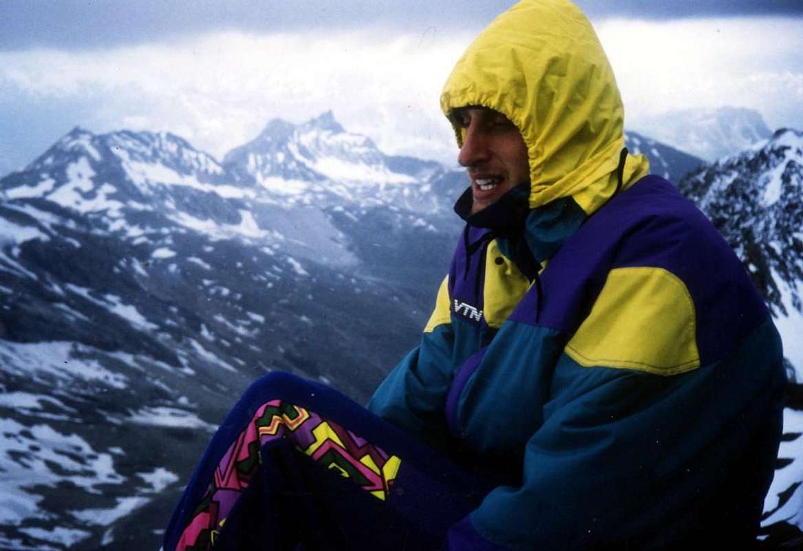
- North-northeast Face: Osvaldo Cardellina and Alessandro Giusto Cardellina; September 22th, 1996, in descent.
- Southeast Crest: Osvaldo Cardellina and Alessandro Giusto Cardellina; September 22th, 1996, in ascent.
- Southern Slope: unknown.
- West-southwest Crest: Alessio Alvazzi Delfrate and Edoardo Rebora with two soldiers; at the beginning of summer 1918, from carving 2877 metres.
- Traverse directly on West Face with descent through North Crest: Osvaldo Cardellina and Giuseppe Lamazzi; August 04th, 1996, in ascent from Arnouva.
Getting There
BY CAR:
- From TORINO, MILANO, etc: Motorway A5. Exit at IVREA or Quincinetto (PIEDMONT).
- From IVREA Town: before in West to Aosta, after in Northwest to Gignod, Etroubles, Saint-Oyen, Saint Rhémy en Bosses, (Southwestern and Northwestern Sides) and in North to Allein, Doues, Valpelline (Northeastern Side) Municipalities. From Courmayeur Resort: a) - to the Val Ferret; or b) - before in East to Aosta, after Northwest to Gignod, Etroubles, Saint-Oyen, Saint Rhémy-en-Bosses Municipalities.
- From Courmayeur-la Palud towards Planpincieux Tronchey, Lavachey Arnouva Dèsot and Bellecombe From Courmayeur-la Palud (1.370m), towards Montitaz (1.550m), Planpincieux (1.593m), Pont, Tronchey (1.620m), Praz Sec du Milieu (1.635m), Lavachey (1.640m), Arnouva Dèsot (1.766/9m) Villages, through Municipal Road; from this last to Bellecombe Vallon and Bellecombe Pass (2.986m).
- From Saint-Oyen or St. Rhémy-en-Bosses to Comba du Merdeux up to the Bellecombe Pass From Saint-Oyen (1.377m), with previous road to Mottes, continue West-northwest to Devies Village (1.723m) at the beginning of Merdeux Comba; from this with paths through Merdeux Dèsott (1.919m), Cotes (1.930m), Manda (1.973m), Tsa de Merdeux (2.285m) Pastures to Bellecombe Pass (2.906m) by Easthern Slope. From Saint Rhémy en Bosses Commune (1.619m), through Municipal Road, on Merdeux Comba to Tsa de Merdeux (2.285m) and Bellecombe Pass (2.906m) from Easth.
- From FRANCE: through the Mont Blanc Tunnel to Entrèves-crossroads to Vény/Ferret Valleys - Mountain Guides of Courmayeur - La Saxe Rock Gym - Courmayeur. By Little Saint Bernard Pass, closed since November until half May to La Thuile Valley - Pré Saint Didier - Courmayeur. It is not necessary to take Motorway A5: you can drive on SS.26, in the direction of AOSTA - IVREA - TURIN.
BY PLANE:
- Aeroporto "Corrado Gex" Saint Christophe (Aosta).
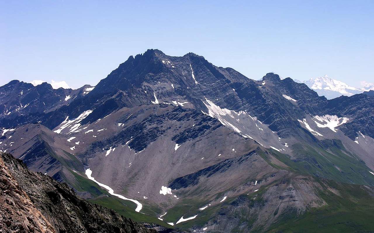
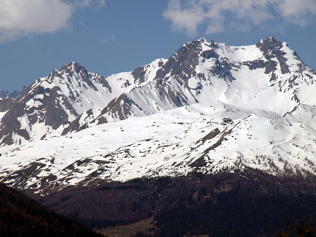
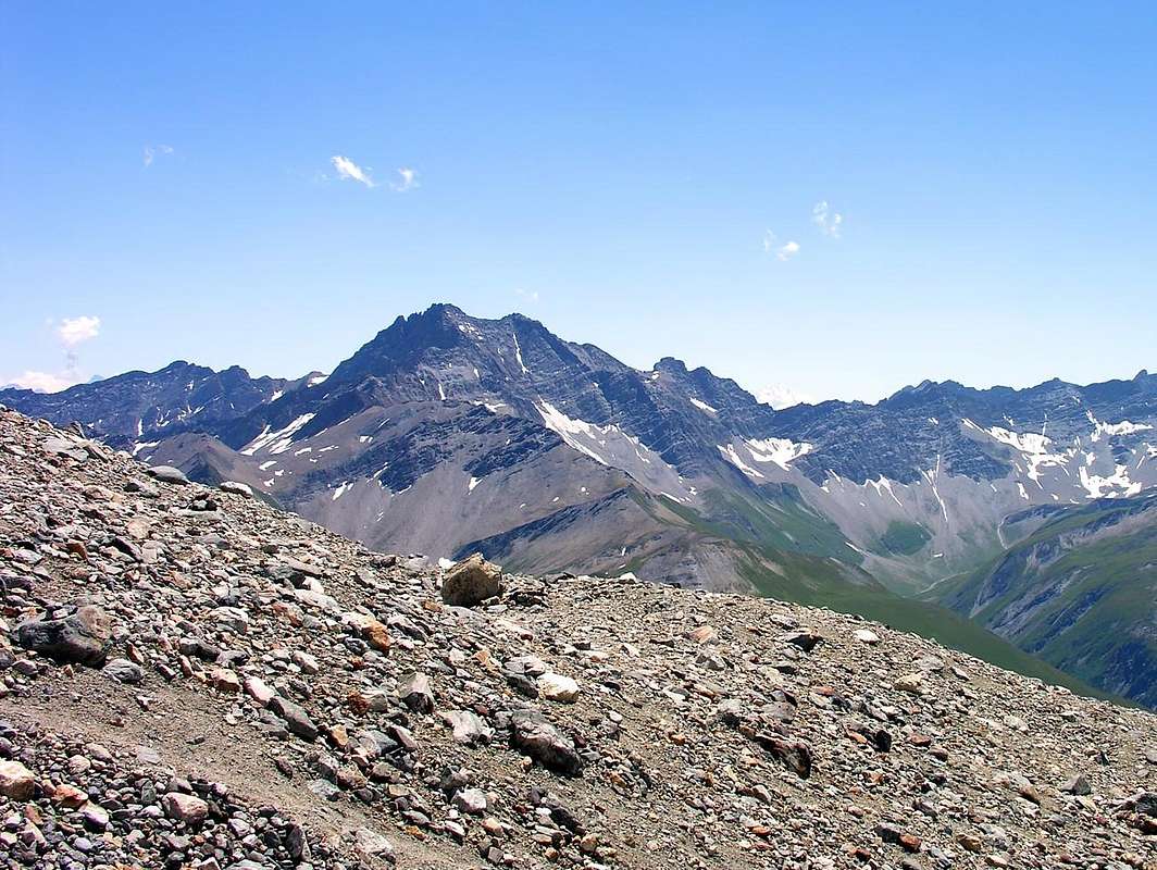
![Traverse ... Aig. de Bellecombe Pt. & Gr. Golliaz 2017]()
![Grand Golliaz...]()
![Aig. de Bellecombe Petit & Grand Golliaz by East 2016]()
Approaches & Routes
Route A (Northern Ridge): this steep ridge, short but sharp and composed of mica schist rocks, rises from the Col de Bellecombe (2.296m) separating the upper part of the homonym to the West by the opposed Vallon des Ceingles in the Easth. Starting from the parking in hearth nearby Arp Nouva Désott Alpage (1.766/9m) to the Bellecombe Pass (2.986m) in the small vallon of the same name, through the path n° 26 up to the Belle Combe Damon Alpage (2.256m; E/F; 1h'30/1h'45), then along boring and steep moraines up to the pass. The climb it is quite easy and short (about 160 meters) and requires not excessive capacity, although in the end some sections are quite exposed and sharp. This itinerary is also useful for the return to the same Bellecombe Pass. However, not be attracted, to make a more rapid pace, from neighboring Southern and Western Walls and Faces, because dangerously quite exposed to frequent falls of rocks and stones. The climbing on the edge of the ridge is fun (I°/I°+/II°-), although in the descent phase should circumvent some stretch (over all in the highest part) towards West (EEA/F+; 0h'20/0h'30 from the carving or pass; 4h'30/5h'00 by Arp Nouva Dèsott).
Via A (Cresta Nord): questa ripida cresta, breve ma affilata nonché composta da rocce micascistiche, risale dal Col de Bellecombe (2.296 m) separando la parte superiore dell'omonimo ad Occidente dall'opposto Vallone des Ceingles ad Oriente. Partendo dal piazzale in terra di Arp Nouva Dèsott (1.766/9 m) e raggiungimento del Col de Bellecombe (2.986 m) nell'omonimo vallone, tramite il sentiero n° 26 fino a Belle Combe Damon (2.256 m; E/F; 1h'30/1h'45) e poi tramite noiose e piuttosto ripide morene. La salita della medesima é abbastanza facile nonché breve (160 metri circa) e non richiede soverchie capacità, anche se nella parte terminale alcuni tratti risultano abbastanza esposti ed affilati. Questo itinerario risulta utile anche per il rientro allo stesso Colle di Bellecombe; comunque non lasciarsi attrarre, per effettuare una discesa più rapida, dalle attigue Pareti e Versanti Est ed Ovest, perché alquanto e pericolosamente esposte alle frequenti cadute di pietre. L'arrampicata sul filo di cresta risulta divertente (I°/I°+/II°-), anche se in fase di discesa conviene aggirare qualche tratto (soprattutto nella parte più alta) verso Ovest (EEA/F+; 0h'20/0h'30 dall'intaglio di Bellecombe; 4h'30/5h'00 da Arp Nouva).
 |
 |
 |
Route B (North-northeast Face from Great St. Bernard Valley through the Combe du Merdeux): from Saint-Oyen, in the locality of Mottes Fraction (1.660m; parking under Saint Bernard Road) also from Bosses-Cuchepache/Ronc Hamlets (+; 1.648m; 1.775m) towards the Comba Merdeux, Montagna Merdeux Dèsott (Low; 1.919m), Muanda or Moindaz Alp (1.973m), Tsa de Merdeux Upper Alp (2.285m), with various paths sometimes concurrent with the farm dirt road to the isolated little Villages of Devies and Maytie on Alta Via n° 1. Through the same towards the Malatrà Hill (2.928m) in West at the end of the valley, with small path-traces alwais remaining on or nearby the Alta Via n° 1. "Lower" Variant: from Maytie (1.676m) towards Limassey Alp (1.808m) through private road and from this, through unnumbered small path to Potz-Ardusi and Muanda Alps (1.784m, 1.973), along the Torrent de la Belle Combe, at the entrance in Merdeux Comba towards the last Alp or Tsa Merdeux Damon (2.285m; T/E; 1h'10/1h'20 by Mottes). By Tsa Damon leaves the High Route for Malatrà Hill and the head of the valley; instead continue towards the North with a not numbered path towards Col de Saulié or des Ceingles. Not even achieve it, but, when it flexes in the Northeast, proceed on stony ground in the opposite direction, taking progressively below the North-northeast Slope of the Aiguille de Bellecombe. Climb the same for very broken and rotten rocks and not always easy or through residues snowfields mixed with steep stony slopes, and finally more easily in terminal part, but always fairly steep, to arrive on Summit (F+/PD-; 1h’30/1h’45 for the North-northeastern Slope from base; 5h’00/5h’30 by Mottes Hamlets).
Via B (Versante Nord-nordest dalla Valle del Gran San Bernardo per la Comba du Merdeux): dal Comune di Saint-Oyen, Mottes Frazione (1.660 m; parcheggio sotto la Strada del San Bernardo) oppure da Bosses-Cuchepache o da Ronc Frazioni (+; 1.648 m; 1.775 m) verso la Comba du Merdeux, Montagna Merdeux Dèsott (Inferiore; 1.919 m), Alpeggio di Manda, Muanda oppure Moindaz (1.973 m), Tsa de Merdeux Alpe Superiore; 2.285 m), tramite vari sentieri a tratti concomitanti con la strada poderale per gli isolati Villaggetti di Devies e Maytie sull'Alta Via n° 1. Con questa al Col Malatrà (2.928 m), tramite sentierini e tracce sempre restando sul percorso od in vicinanza dell'Alta Via n° 1. Variante "Bassa": dall'Alpeggio di Maytie (1676m), subito appresso a Mottes e Devies, verso quello viciniore di Limassey (1.808 m) tramite la strada privata poderale e da questo, con sentierino non numerato a quelle di Potz-Ardusi e Muanda o Moindaz (1.784m, 1.973), affianco al Torrent de la Belle Combe affluente del sottostante Rio Artanavaz (antico Buthier de Bosses), nonché all'entrata della Comba du Merdeux Comba in direzione dell'Alpe ultima o Tsa del Merdeux Damon (2.285 m; T/E; 1h'10/1h'20 da Mottes). Dalla Tsa Damon abbandonare l'Alta Via per il Colle di Malatrà e proseguire invece verso Settentrione con un sentierino non numerato verso il Col de Saulié o des Ceingles. Non raggiungere neppure quest'ultimo, bensì, quando questo flette a Nordest, procedere sulla pietraia in direzione opposta portandosi progressivamente al di sotto del Versante Nord-nordest dell'Aiguille de Bellecombe. Salire il medesimo per rocce molto rotte e non sempre facili oppure per residui di nevai frammisti a ripidi pendii petrosi ed infine più facilmente con l'ultimo tratto, sempre abbastanza ripido, si raggiunge la Vetta (F+/PD-; 1h’30/1h’45 per il Versante Nord-nordest; 5h’00/5h’30 dalla Frazione di Mottes).
Difficulty & Equipment
This route can be considered E/F or EEA/F+/PD- (Experts Hikers and Mountaineers); BSA in winter (even by Ski).L'itinerario è da classificare in E/F oppure EEA/F+/PD- (Escursionisti Esperti od Alpinisti). BSA in inverno (anche in Scialpinismo).
Hiking gear, in winter as for Ski-Mountaineering.
Da Escursionismo, in inverno da Scialpinismo.
 |
 |
 |
Campings
Remember that free camping is forbidden (except for emergency reasons, above 2.500m, from darkness until dawn).
Mountain Condition
- Meteo: you can find all the needed informations at the official site of the Valle d'Aosta Region:
- Valle d'Aosta Meteo
Books and Maps
- "Guida dei Monti d'Italia-Alpi Pennine" (Vol. I°) di Gino Buscaini-Club Alpino Italiano/Turing Club Italiano, Luglio 1971 (in Italian).
- "Diari Alpinistici" di Osvaldo Cardellina e Indice Generale accompagnato da Schedario Relazioni Ascensioni 1964-2019 (inediti).
- "80 itinerari di Escursionismo Alpinismo e Sci Alpinismo in Valle d'Aosta", di Osvaldo Cardellina, Ed. Musumeci, Giugno 1977 (in Italian); seconda Ed. Luglio 1981; terza Ed. Luglio 1984; (in French), prima Ed. Febbraio 1978; seconda Ed. Marzo 1980.
 |
 |
 |
- Kompass "Massiccio del Monte Bianco Valle d'Aosta Sentieri e Rifugi" Carta turistica 1:50.000.
- I.G.C. Istituto Geografico Centrale Torino "Massiccio del Monte Bianco" (carta n° 4), Torino, 1998 1:50.000.
- I.G.C. Istituto Geografico Centrale Torino "Monte Bianco-Courmayeur-Chamonix M.B.-La Thuile" (carta n° 107), Torino 1989 1:25.000.
- I.G.M. Istituto Geografico Militare "Gr. Rochère" 1:25.000.
- L'Escursionista "Monte Bianco Courmayeur" Edizioni Rimini 2004 1:25.000.
- Edizioni Tabacco "Mont Blanc" Udine, 1978 1:50.000.
- Studio F.M.B. Bologna 1988 "Monte Bianco-Mont Blanc" 1:50.000.
- Carta Comunità Montana "Valdigne e Mont Blanc Les Sentiers", 2001 1:50.000.
![]()
mportant Information
- REGIONE AUTONOMA VALLE D'AOSTA the official site.
- FONDAZIONE MONTAGNA SICURA Villa Cameron, località Villard de la Palud n° 1 Courmayeur (AO) Tel: 39 0165 897602 - Fax: 39 0165 897647.
- Società Guide Alpine Courmayeur www.Guidecourmayeur.com - Strada Villair n° 2 - 11013 Courmayeur (Aosta) Italy - Tel. +390165842064 Fax. +390165842357 - P.I. 01022640070
- A.I.NE.VA. (Associazione Interregionale Neve e Valanghe).
Useful numbers
- Protezione Civile Valdostana località Aeroporto n° 7/A Saint Christophe (Ao) Tel. 0165-238222.
- Bollettino Meteo (weather info) Tel. 0165-44113.
- Unità Operativa di Soccorso Sanitario Tel. 118.