
-
 25987 Hits
-
 86.72% Score
-
 24 Votes
|
|
Mountain/Rock |
|---|---|
|
|
45.90300°N / 7.87146°E |
|
|
Valle d'Aosta, Piemonte |
|
|
Mountaineering, Skiing |
|
|
Spring, Summer |
|
|
13274 ft / 4046 m |
|
|
Overview
Punta Giordani 4046 m
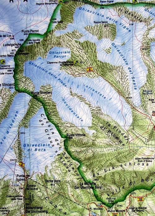
Punta Giordani 4046 m is a mountain belonging to the Monte Rosa Group in the Pennine Alps and one of the easiest 4000s to be climbed. It is located along the watershed separating the high Lys valley in the county of Valle d'Aosta from the upper Valsesia in the Piedmont side. Punta Giordani is a minor summit, almost an East shoulder of Piramide Vincent, anyhow it's considered as a true summit, belonging to the 4000 of the Alps. Check here the complete list of the 82 alpine Fourthousanders and the 46 minor summits: Club4000.
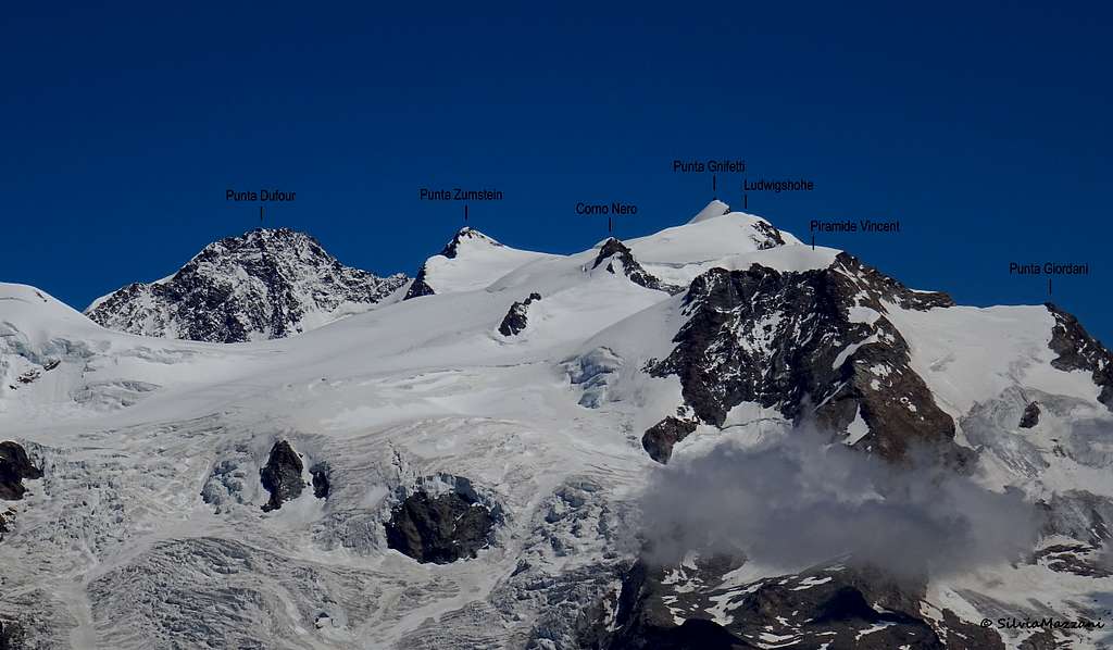
Punta Giordani falls on the East side (to Val Sesia) with a high (700m) rock wall, while on the West side is a gentle icy summit. It's the lowest 4000 within the Monte Rosa Group, anyhow it's a very nice summit, often climbed in one day starting from the valley floor, facilitated by the car-lift both from the Valle d'Aosta and Piedmont sides. It is therefore visited by many mountaineers as a not too demanding destination or as training and acclimatization in view of more demanding ascent. The summit views are is quite remarkable, above all towards the Val Sesia side.

|

|
Getting There
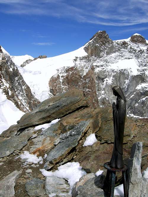
Summit of Punta Giordani
Starting point: Alagna Valsesia (Piedmont) or Staffal (Valle d'Aosta) with two different road approachs:
Access via the Val Sesia (Piedmont) - From the A26 Highway exit to Romagnano Sesia and take the road to Varallo Sesia. Here continue following all the Val Sesia road to Alagna Valsesia. From Alagna Valsesia take the Cable car to Pianalunga - Passo dei Salati – Indren.
Access via the Valle di Gressoney (Aosta Valley) - From the A5 Torino – Aosta Highway, exit to Pont St. Martin and take the Valle di Gressoney, getting to Gressoney St. Jean, Gressoney La Trinité and Staffal. From Staffal take the Cable car to Alpe Gabiet – Passo dei Salati - Indren
By airplane: Airport Torino Caselle 134 km Airport Milano Linate 110 km Airport Milano Malpensa 70 km Airport Bergamo Orio Al Serio 160 km From Malpensa each half a hour a bus connects the airport with Milano Centrale station, then continue by train to Varallo Sesia or getting on a bus(starts 08.00; 10.00; 12.00; 15.00; 17.00; 20.00;21.00 from Terminal 1) to Novara and continue Varallo Sesia by train. From Linate each half a hour a bus connects the airport with Milano Centrale station, then by train to Varallo Sesia. From Orio al Serio by Autostradale bus to Milano Lambrate or to Piazza Bottini.
By train: The nearest station to Alagna is Varallo Sesia 36 Km, then by bus.
By bus: From Varallo station: bus to Alagna (Atap) The voyage takes about 1 hour.
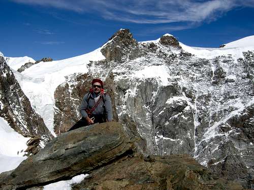
Punta Giordani Normal route
Punta Giordani Normal route
Difficulty: F
Length: 780 m vertical gain
Starting point: Punta Indren
The Normal route along the Western slopes is an easy ascent on a glacier, with a brief final rock climb. It can be climbed in one day starting both from Val Sesia and Gressoney, facilitated by the car-lift.

|

|
From Staffal (valle Gressoney) or Alagna (Val Sesia) take the cable car to Punta Indren upper station 3260 m. From here reach the Indren glacier, pass the arrival of the old Roccette skilift, bend right in the direction of a second sky lift on a generally traced path. You pass a ski lift, then reach the second by turning right. Up the glacier progressively steepening, leave a huge serac on the left and reach a band of rocks and debris. The last steep slope leads to a flat snowy crest, just below the final rocks. Climb this short stretch, getting the summit with the little Madonna.
Descent: reversing the route
Cable-car info: Monterosa cable cars - Alagna Valsesia funivie
Cresta del Soldato
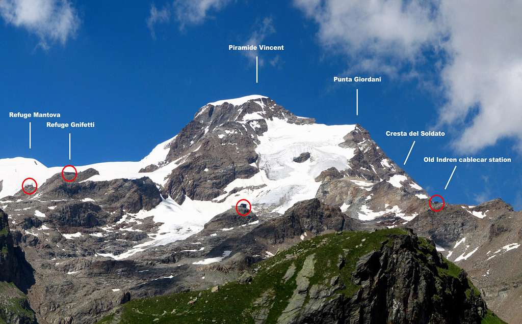
"Cresta del Soldato" is the SE rocky ridge of the Punta Giordani. The curious name was attributed by William Martin Conway, who climbed it in 1884 accompanied by an Italian soldier. Refers to the only partThe ridge from Punta Giordani to Piramide Vincent is the logic extension of it. Despite most of the climbers cross both the summit, the name "Cresta del Soldato" is related only with the part from Colle Bors to Punta Giordani. The ridge is mostly composed by red gneiss rocks, typical of Monterosa. Funny rock passages of II/III with a plaque of IV-. See here the full route-report in the page by the SP member Andrea: Cresta del Soldato
Other routes
On the big wall facing Valsesia there are at most 2 routes, one crossing the big channel (very dangerous) and another one, the "Via degli Alpini" that goes straight, with some very difficult passages, along the wall on the left side (S) of the channel. The N wall also has been climbed but very seldom or maybe never been repeated.
Red Tape
No fees no permits required
Costs: cableway to P.ta Indren.
Summit views

|

|
When To Climb
Mountaineering: from the end of June to middle September
Ski-mountaineering: from the end of March to the end of May

|

|
Camping
Camping in Alagna or camping near Punta Indren in tent.
Meteo
Meteo Valle d'Aosta
Meteo Piemonte
Guidebooks and maps

"Monte Rosa - Val d'Ayas e Valle di Gressoney" by Andrea Greci, Federico Rossetti - Idea Montagna ed. 2020
“Monte Rosa” by Gino Buscaini - Guida dei Monti d'Italia C.A.I.-T.C.I.
"Il grande libro dei 4000 - Vie normali e classiche" by Marco Romelli, Valentino Cividini - Idea Montagna Editore, 2015
“Tutti i 4000 – L’aria sottile dell’alta quota” – Club 4000, CAI Torino – Vivalda Editori
“4000 delle Alpi” by Richard Goedeke - Ed. Libris
Maps
"Breuil/Cervinia-Zermatt" Kompass map 1:50.000.
"Cervino-Matterhorn e Monte Rosa" n. 5 - Istituto Geografico Centrale map 1:50.000
"Monte Rosa" - Swisstopo 47
"Gressoney" - Swisstopo 294
General Info
Cableway phone: 0163.922922. Time table and Cable-car info: Monterosa cable cars - Alagna Valsesia funivie