
-
 19535 Hits
-
 92.04% Score
-
 37 Votes
|
|
Mountain/Rock |
|---|---|
|
|
45.93933°N / 7.75446°E |
|
|
Aosta Valley, Zermatt, Italia, Svizzera |
|
|
Mountaineering |
|
|
13648 ft / 4160 m |
|
|
Overview
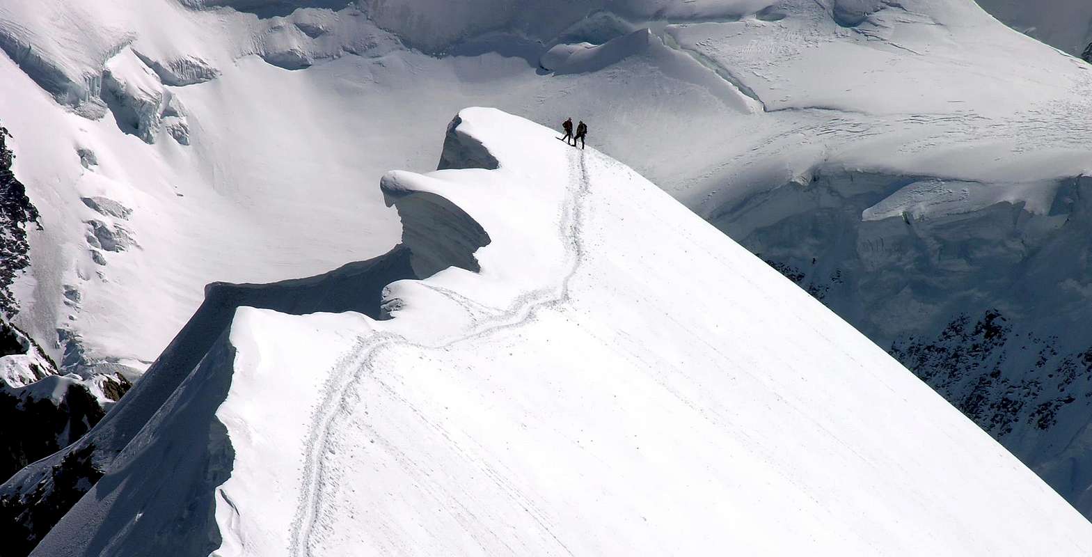
Inferior Beautiful peak of few meters to the Breithorn Occidentale (4.165m), of which is very less frequented. The mountain possesses great glacial streets on the wall N, while it is being the only one of the Breithorns to introduce on the slope S rocky itineraries. Grandiose panorama on the whole alpine entourage.
Bella vetta di pochi metri inferiore al Breithorn Occidentale (4.165 m), del quale è molto meno frequentata. La montagna possiede grandi vie glaciali sulla parete N, mentre è l'unica dei Breithorn a presentare sul versante S itinerari rocciosi. Grandioso panorama su tutta la cerchia alpina.
First Ascents
- First in the summit: Edouard Hahn and company, (Jul 19th, 1900).
- In winter: Unknown.
- W Arête (normal route): Unknown.
- N Wall (for Triftjiplateau): Enrico Cavalieri and Oliviero Frachey, (Sep 11th, 1958).
- N Wall ("Dessert semi-freddo" route): L. Bordoni and Gian Carlo Grassi, (Jul 18th, 1985).
- N Wall (Frachey-Cetti Sebelloni route): Francesco Cetti Serbelloni, Ernesto and Oliviero Frachey, (Aug, 1953).
- N Wall ("Viaggio di ordinaria follia" route): Gian Carlo Grassi, Bernard Mailhot and Enrico Tessera, (Jun 24th, 1984).
- N Wall (direct route): Pierre-Alain Steiner and Patrick Gabbarou, (Sep 17th, 1979).
- N Wall (Spettro glauco route): Gian Carlo Grassi, Vincenzo Ravaschietto and Angelo Siri, (Jul 24th, 1985).
- N Wall (Torre maggiore route): Lino Castiglia, Pietro Crivellaro, Ugo Manera, Claudio Persico and Luciano Pezzica, (Sep 07th, 1980).
- E Arête: Edouard Hahn and company, (Jul 19th, 1900).
- SE Wall (E eperon): Vittorio De Tuoni and Marco Barmasse, (Mar 20th, 1983).
- SE Wall: Vittorio De Tuoni and Marco Barmasse, (Mar 20th, 1983).
- SE Wall (Central eperon): Enrico Cavalieri, Giovanna Cerri, Gianna Dagnino and Gianni Migliorino, (Aug, 1964).
- SE Wall (W eperon): Vittorio De Tuoni and Marco Barmasse, (Jul 27th, 1985).
- S-SW Eperon: E. R. Blanchet, Jean Chaubert and Kaspar Mooser, (Aug 17th, 1925).
- S-SW Slope: Dario Gariglio, Giuseppe Gennari and Angelo Serra, (Apr 20th, 1968).
 |
Getting There
BY CAR:
- From Torino, Milano, etc: Motorway A5. Exit at Aosta Est.
- From Switzerland: through the Grand Saint Bernard Tunnel or the namesake pass.
- From France: through Mont Blanc Tunnel or Petit Saint Bernard Pass. It isn't necessary to take Motorway A5: you can drive on SS.26, in the direction of Aosta.
BY PLANE:
- Aeroporto "Corrado Gex" Saint Christophe (Aosta).
Route
From the exit of the motorway of Chatillon to continue on the SR.406 along the Valtournenche Valley, after having overcome the Countries of Antey Saint André (1.074m), Valtournanche (1.528m) Breuil Cervinia is reached (2.006m) where almost to center of the country it is situated the funivia (with ample parking lot), that reaches Plan Maison (2.548m) and to the Plateau Rosà (3.480m) from where the itinerary begins.
Dall'uscita del casello autostradale di Chatillon proseguire sulla SR.406 lungo la Valtournenche, dopo aver superato i Paesi di Antey Saint André (1.074 m), Valtournanche (1.528 m) si raggiunge Breuil Cervinia (2.006 m) dove quasi a centro del paese è situata la funivia (con ampio parcheggio), che porta a Plan Maison (2.548 m) e al Plateau Rosà (3.480 m) da dove inizia l'itinerario.
Itinerary
From the "Testa Grigia" (3.480m; Rifugio Guide del Cervino); for the glacier of the Plateu Rosà to address him to And on numerous traces toward the Breithorpass or Hill of the Breithorn (3.818m), of few to N of the Hump of Rollin (3.899m). To Continue on the Breithorplateau with direction reaching with light descent Of it the underlying basin the Saddle (4.075m) to quota 3.780 meters~ to go up again the frozen slope S-SW for ~300 meters with inclinations from 35° to 50° (crevasses) and, without forced run, to go out on the crest W or directly in peak with possibility of plates of alive ice in the last line. The slope becomes more interesting and elegant climbing in parallel and to not a lot of distance of the spur S-SW (1925 Blanchet-Chaubert-Mooser route) with a gradient of ~380 meters (2h'30/3h'00).
Descent: It is worthwhile to go down for the crest W to the saddle (4.075m), going up again to the Breithorn Occidentale for the easiest crest And-if and for the frequented slope S-SW.

Dalla Testa Grigia (3.480 m; Rifugio Guide del Cervino); per il ghiacciaio del Plateu Rosà indirizzarsi ad E su numerose tracce verso il Breithorpass o Colle del Breithorn (3.818 m), di poco a N della Gobba di Rollin (3.899 m). Continuare sul Breithorplateau con direzione NE raggiungendo con leggera discesa la conca sottostante la Sella (4.075 m) a quota 3.780 m~ risalire il ghiacciato versante S-SW per ~300 metri con pendenze da 35° a 50° (crepacciato) e, senza percorso obbligato, uscire sulla cresta W o direttamente in vetta con possibilità di placche di ghiaccio vivo nell'ultimo tratto. La salita diventa più interessante ed elegante salendo in parallelo ed a non molta distanza dello sperone S-SW (via Blanchet-Chaubert-Mooser 1925) con un dislivello di ~380 metri (2h'30/3h'00).
Discesa: Conviene scendere per la cresta W alla sella (4.075 m), risalendo al Breithorn Occidentale per la più facile cresta E-SE e per il frequentatissimo versante S-SW.
Difficulty
PD in ascent; PD-/F in descent.
PD in salita; PD-/F in discesa.Gear
High mountain gear: rope, iceaxe, crampons.
Da alta montagna, corda, piccozza, ramponi.
")


Huts
Rifugio GUIDE DEL CERVINOCampings
Remember that free camping is forbidden (except for emergency reasons, over 2.500m, from darkness until dawn).
Mountain Conditions
- You can get meteo information at the official site of the Regione Valle d'Aosta:
- Valle d'Aosta Meteo
Webcam
- WEBCAM on Aosta Valley:
- Webcam
Books and Maps
BOOKS:
- "Guida dei Monti d'Italia - Alpi Pennine (Vol.2)" di Gino Buscaini - Club Alpino Italiano/Turing Club Italiano, Luglio 1970 (In Italian).
- "Diari Alpinistici" di Osvaldo Cardellina e Indice Generale accompagnato da Schedario Relazioni Ascensioni 1964-2019 (inediti).
- "Guida delle Alpi Occidentali" di Giovanni Bobba e Luigi Vaccarone C.A.I. Sezione di Torino Volume II (parte II), 25 Maggio 1896.
- "Rifugi e bivacchi in Valle d'Aosta", di Cosimo Zappelli aggiornata da Pietro Giglio, Musumeci Editore, Luglio 2002.
- "I Rifugi della Valle d'Aosta" di Stefano Ardito, Ed. Guide iter, Febbraio 2003.
")


MAPS:
- Kompass "Breuil/Cervinia-Zermatt" Carta turistica 1:50.000.
- I.G.C. Istituto Geografico Centrale Torino "Cervino e Monte Rosa" 1:50.000.
- Studio F.M.B. "Cervino Monte Rosa" Bologna 1:50.000.
- I.G.C. Istituto Geografico Centrale Torino "Monte Rosa Alagna e Macugnaga" (n° 10), 1:50.000.
Important Information
- REGIONE AUTONOMA VALLE D'AOSTA the official site.
- FONDAZIONE MONTAGNA SICURA Villa Cameron, località Villard de la Palud n° 1 Courmayeur (AO) Tel: 39 0165 897602 - Fax: 39 0165 897647.
- SOCIETA' DELLE GUIDE DEL CERVINO Via Jean Antoine Carrel, n° 10 - 11021 Breuil Cervinia - Valtournenche (AO) - Italia.
- A.I.NE.VA. (Associazione Interregionale Neve e Valanghe).
Useful Numbers
- Protezione Civile Valdostana località Aeroporto n° 7/A Saint Christophe (Ao) Tel. 0165-238222.
- Bollettino Valanghe Tel. 0165-776300.
- Bollettino Meteo Tel. 0165-44113.
- Unità Operativa di Soccorso Sanitario Tel. 118.