
-
 14875 Hits
-
 86.37% Score
-
 22 Votes
|
|
Area/Range |
|---|---|
|
|
43.96110°N / 109.3392°W |
|
|
Hiking, Mountaineering, Trad Climbing, Ice Climbing, Scrambling |
|
|
Summer |
|
|
13153 ft / 4009 m |
|
|
Overview

The Southeast Absaroka Range is part of the huge Absaroka Range, which is commonly divided into four sections; the other three parts are known as the Montana Absarokas, the Northern Absarokas, and the Southwest Absarokas. The South Fork of the Shoshone River and Du Noir Creek run along the west and north sides and make up the dividing line that separates this part of the range from the other sections.
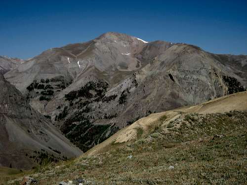 Mount Crosby -- by musicman82
This is very wild and beautiful country, and the types of wildlife found here are numerous. Predators like wolves, mountain lions, and grizzly bears are everywhere; in fact, it is rare to hike anywhere in this area and NOT see bear tracks!
The mountains here are formed from layers of volcanic debris that are thousands of feet thick, and the most common type of rock found in these mountains is breccia, which is also affectionately known as kitty litter due to its crumbly and unstable nature. This makes rock climbing here a very risky undertaking, and only two peaks (the Ramshorn and Washakie Needles) are commonly climbed via easy class 5 routes.
Wide open meadows of green grass and thick wildflowers are one of the special attractions in this area and long, gentle slopes are characteristic of the majority of the mountains here. Most of the peaks are fairly easy Class 2 hikes, but with a few exceptions, many require you to walk for 15 miles or more to reach them. The Southeast Absarokas contain the 18 highest peaks in the entire Absaroka Range, including Francs Peak, which is the only mountain over 13,000 feet. There are 37 other peaks here that cross the 12,000-foot barrier, and there are numerous other mountains above 10,000 feet.
While Francs Peak and the Washakie Needles are attempted more frequently due to their status as county highpoints, the majority of these summits rarely see human footprints; if you want to see some truly wild country that sees relatively few visitors, this is the place.


Getting There/Access Points
 Near East Fork Pass -- by Bob Sihler
 Mountains around Cascade Creek -- musicman82
Highway 291, the South Fork Highway, runs from Cody, Wyoming in a generally southwest direction along the northern border of the range. From this road one can appreciate the massive length of Carter Mountain and take in numerous other beautiful peaks in the area; the road enters the Shoshone National Forest and ends after about 40 miles in a valley surrounded by 11,000-foot peaks. The north side of Carter Mountain, which is a spectacular wall measuring over 3,000 feet high, is a popular ice climbing location. Several trails head into the range near the end of the highway.
 Francs Peak -- by jimmyjay
 Washakie Needles -- by jimmyjay
 Carter Mountain -- by musicman82
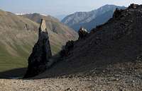 Greybull Pass -- Bob Sihler
Heading south from Meeteetse, WY, Highway 290 provides access to the heart of the Southeast Absarokas. The main road leads to Sunshine and Pitchfork Reservoirs and the ring of peaks that surround this valley, including the south side of Carter Mountain. An important drainage to the south here leads back to the headwaters of the Greybull River. Branching south off of this highway, the Wood River Road eventually leads to the ghost town of Kirwin at 9,200 feet, where many trails branch out to incredibly high mountain passes and the highest peaks in the range, including Francs Peak and Jojo Mountain.
 Breccia pillar -- Bob Sihler
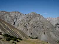 Mount Sniffel -- by musicman82
Highway 174, which follows Owl Creek off of the Hamilton Dome road, is a tricky option for the approach to the Washakie Needles and the surrounding peaks on the southeastern edge of the range because of land closure by the current owner; as of the most recent information I've seen, special permission is required to cross this area.
Forest Road 277 runs from about 13 miles southeast of Dubois, WY north to near the Washakie Wilderness boundary. This allows for a longer approach to the peaks on the southern side of the range.
Horse Creek Road (Forest Road 285), which heads north out of the town of Dubois, also reaches the southern side of the range, including Ramshorn Peak and Raggedtop Mountain.
Peaks
As stated above, there are 38 mountains in the Southeast Absarokas that are higher than 12,000 feet (following the 300-foot prominence rule), and it is interesting to note that 18 of these peaks are unnamed. Following the pattern established on Bob Sihler's Northern Absaroka page, I've limited the peaks listed here to those with pages on SummitPost and those found in Thomas Turiano's excellent book Select Peaks of the Greater Yellowstone.Peaks listed only in Turiano's book are in bold and peaks found only on SummitPost have links; if the mountain is found in both places, it has bold text and a link. Ratings are given for the standard route on each peak.
Francs Peak-- 13,153', Class 2
Peak 12635 "Jupiter Peak"-- 12,635', Class 2
Washakie Needles-- 12,518', Class 5.2
Mount Crosby-- 12,449', Class 2
Carter Mountain-- 12,319', Class 1
Red Tops-- 12,242', Class 3
Wiggins Peak-- 12,176', Class 2
Brown Mountain-- 12,161', Class 2
Needle Mountain-- 12,106' Class 2
Spar Mountain-- 12,086', Class 2
Raggedtop Mountain-- 11,813', Class 2
Peak 11694-- 11,694',
Ramshorn Peak-- 11,635', Class 4-5
Bald Mountain-- 10,536', Class 1
Red Tape
None of the areas in this range require fees for access. The vast majority of the range lies within the confines of the Shoshone National Forest and the Washakie Wilderness, which means that special rules pertaining to food storage, etc., are in order due to the large grizzly bear population.Many of the roads that lead into the range are not passable in winter, and some of them, especially the road to Kirwin, can be dicey in the early summer due to runoff on the river that crosses the road in several places.