
-
 19942 Hits
-
 92.59% Score
-
 39 Votes
|
|
Area/Range |
|---|---|
|
|
48.86600°N / 16.66600°E |
|
|
Hiking, Trad Climbing, Sport Climbing, Bouldering, Scrambling |
|
|
Spring, Summer, Fall, Winter |
|
|
1818 ft / 554 m |
|
|
Overview
I feel a strong connection to this place. This is where we used to go for a short hike on Sunday afternoons with my family, and whenever I visit my home, I always find a time to visit Pálava.
These limestone walls are not very high, the highest point Děvin is only 554 meters above sea, but are very visible as their white rocks rise out of an otherwise fairly flat landscape. The elevation at the water reservoir on river Dyje is only 160 m a.s. The altitudinal difference between the river and the top of Devin is 389 m.
Palava is the warmest and one of the driest parts of the Czech Republic, many plant species that could not grow anywhere else in the Czech Republic occur here.
Folk etymology translates the name Pálava as "earth burnt by the sun" after the dry and warm climate throughout the region.
The Palava Protected Landscape Area was established in 1976 on 83 km2. In 1986 it was listed on UNESCO biosphere reserve.

Pálava as seen from the reservoirs on the river Dyje = Thaya
The northernmost hilltop with the ruin of the castle Divci Hrad (=Maidenstein) stands out above the village of Pavlov. Southwards, the highest Děvin Hill (554 m) follows, which is separated in the south by the narrow gorge called Soutěska from Kotelna Hill (462 m). Růžový vrch (= Pink Hill translated into English), with another castle ruin on the top, and Stolová Hora (Table mountain in English, 459 m), with a prominent plateau, form the central part of the range. Turold Hill (385 m) and Svatý kopeček (Holly Hill, 363 m), the latter with a church on its top surround the town of Mikulov. The southermost Sibeničnik Hill (238 m) is situated on the border with Austria. Schweinbarther Berg, Hohlenstein, and Falkenstein Hills in the adjacent part of the Lower Austria belong to the same range.
Pálava Lakes The three Nové Mlýny reservoirs on the river Dyje below the Pálava, also referred to in popular media as the Pálava Lakes, comprise Moravia's largest body of water covering 3,227 hectares. They were built in stages between 1975-1988; their construction was opposed by many environmentalists as the water flooded extensive alluvial forests, meadows and wetlands. However, as a result of the flooding, the Middle Lake has become an important bird area - a waterfowl nesting and gathering place of European importance, while the other two reservoirs (the Upper or Mušov Lake and the Lower or Nové Mlýny Lake) are popular for recreation.

One of Pálava Lakes called Mušov
Getting There
Pálava is situated in the southernmost part of Moravia, Czech Republic, between the river Dyje (in German Thaya) and the Czech-Austrian border.From Brno - take road E461 towards Wien (Vienna). It is about 35 km. There are signs pointing towards Pálava, and you will be able to see your destination from at least 30 km.
From Vienna - follow directions towards Brno, road B7. After entering the Czech Republic and driving through the town of Mikulov, you will see signs pointing towards Pálava (and you will see it). It is located about 70 km north of Vienna.

The map shows the main road E461 connecting Brno and Vienna. You can take any exit towards Palava (or Pavlovske vrchy as written on the map). I drove around the hills and stopped at several trailheads. The best trailhead for rock climbing is from the village of Horni Vestonice.
Red Tape
 Trail marking
 |  Green and Blue Trail
 |
There is no entrance fee, parking is available for free at several trailheads.
They do not allow mountain biking in the protected area, but around the Pálava Hills are great roads for road/mountain biking.
Hiking - very popular with several different and interconnecting trails, which are well marked with above photographed marks located usually on trees, and sometimes on rocks.
Climbing - allowed only seasonally (due to nests of rare birds) from 1st of September to the end of December. 
Hiking
There are several trails for tourists in the area. For a quick visit I would recommend the following route. Start Klentnice (0km) - Sirotči Hrádek (0.5 km) - ruins of chapel (2.5 km) - ruins of Nový Hrad (3.5 km) - ruins of Divči Hrad (6 km) - top of Děvin, the highest point of Pálava (7km) - and back to Klentnice (10.5 km). This is a round trip (start and end at the same spot).
To view all Pálava hills this route would be better, but requires 2 cars, or return via the same route making this trip a little bit longer (10.5 km one way, or 21 km round trip). Start in the village of Pavlov, and continues along the green path up to the ruin of Castle Divči Hrad (1.2 km). This route goes first through the vineyards, then through the woods. From Divči Hrad you continue on red path to the peak of Děvin (2.2 km). From Děvin you descend down to Soutěska and follow signs towards Klentnice (5 km), where the red tourist path turns to the right and climbs to the ruin of Sirotči hrad (=castle), 5.5 km. From here you head to hill Stolová hora (6.1 km), to the natural preserve Tabulová Hora. Here you drop again to the crossroads "Pod Tabulovou"(=under the Table mountain), you walk pass the natural formation "Kočiči skala" (Cat's rock), and climb again through the vineyards to the peak of Turold (8.7 km). The read signs will lead you the the center of the historic town of Mikulov.
Of course you can make many different combinations. I remember days when we used to come just to the ruins of Divči hrad, and played there.
 Red Trail
 |  Hike to Divči Hrad
 |  Off the main trail
 |  Winter Trail
 |  Overlook
 |
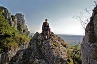 Family Scramble
 |  Main Summit
 |  Pod Martinkou
 | 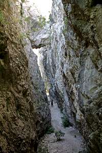 Narrow Passage
 |  Off the main trail
 |
Rock Climbing
Rock Climbing area includes several large rock cliffs: Martinka, Vzývajici and Trůn. The best approach is from the village of Horni Věstonice, about 10 to 15 min hike on a nice trail (green tourist mark).Rock climbing season is very short here due to the nesting of rare birds, per latest news: "Rock climbing activity is allowed from September 1st to December 31st, from 9:00 to 18:00. This is valid till December 31st, 2013." Climbing permit information - only in CzechRock climbing guide- in Czech Between Martinka and Obří Kámen
 |  Trying out some routes off season
 |  Obří Kámen
 |  Martinka
 |
 Ancient piton
 | 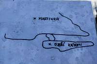 Illustration
 |  Route Name
 |  Clifs as seen from the trail
 |
History
The Pavlov Hills are located in the middle of the ancient cultural landscape of southern Moravia, which is one of the oldest inhabited areas in the Czech Republic. A hunting camp of the Stone Age mammoth hunters was situated between the villages of Dolni Vestonice and Pavlov, and lots of mammoth bones and remains of fireplaces, but also the famous Vestonice Venus statuette were left behind.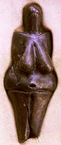
The farmers appeared in this area very early in the Neolithic period, and in the 2nd century a Roman military campsite existed on the river Dyje.
Ruins of Castle Divci Hrad (=Maiden Castle translated into English, or Maidenberk, also Devicky) - there are several legend about this castle. One legend talks about a treasure hidden somewhere below the castle, the other legends are about maidens (I guess therefore the name). I liked the legend about a beautiful and very rich Tatar princess, who was killed here. The local lord invited her to stay at the castle and tempted by her wealth killed her. He threw himself down from white cliffs after this horrible act. There are legends about white ghosts looking like young maidens wandering around. I have not seen any. The castle was burnt by Swedes in 1645, and since then it was falling apart.
 |  |  |  |  |  |  |  |  |


Geology
The landscape of the Pavlov Hills has outcrops and cliffs of pure, hard, and white limestone of Upper Jurassic origin, called Ernstbrunn limestone. The Pavlov Hills are situated at the margin of the flysch zone of the Eastern Alps and Western Carpathians. In the Upper Tertiary period, the Pavlov Hills were surrounded by a warm sea. During the Quaternary fossils were deposited on the footslopes of the Pavlov Hills. The limestone creates beautiful karstic formations and caves. The Turold cave is the biggest one. Sandstone, sandy marls, loess and sedimentary deposits of the Dyje river form the rest of the area. Due to a diversity of subsoil, the area has a large range of flora. The lakes below the hills are significant ornithology location.
Nature Reserve Svaty kopecek
Svaty kopecek (363 m, Heiliger Berg in German) is flanking the town of Mikulov from the east. The hill is formed of white and hard Jurassic limestone. Its northwestern part was destroyed by the quarrying of limestone lasting from 1816 to the early 1970s.The fifteen Stations of the Cross along the path to the hilltop were established in 1626-1723. The white Baroque pilgrimage Church of St. Sebastian and the neighbouring campanile on the flat top were build in the 17th century. By construction of these buildings catholic church tried to support the Counter Reformation and to break up the old pagan belief that the hill summit was the meeting point of witches, as documented by the original German name of the hill - Tanzberg (Hill of Dances). From the top of Svaty Kopecek there is a nice view of the medieval town of Mikulov, dominated by a chateaux. Svaty kopecek has been protected nature reserve since 1946.

Accommodations
There are several campgrounds long the river Dyje (Thaya) reservoirs, and a lot of bed&breakfast type of accommodations (just see signs for Zimmer frei = free room, free meaning available and not gratis). The town of Mikulov has several hotels, and the nearby villages offer hotel type accommodation as well.There is no camping allowed within the protected landscape area, but I am not sure how strict this restriction is. E.g. I notices campfire sites near the climbing area, and there was a sign prohibiting open fire. I never met any park ranger person during my hikes in Palava hills.
Area map

External Links
Botanical guideMore photos
Palava info
Palava Biosphere Reserve
Weather
 |
 |