
-
 12388 Hits
-
 80.49% Score
-
 12 Votes
|
|
Mountain/Rock |
|---|---|
|
|
38.55250°N / 106.3507°W |
|
|
12856 ft / 3919 m |
|
|
Overview
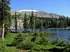
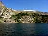
Bald Mountain lies along the Continental Divide north of Monarch Pass and towers over the beautiful Waterdog Lakes area, a popular day hike from a trailhead on U.S. Highway 50. The Continental Divide Trail skirts the western slope of the summit, missing the summit by only a few hundred vertical feet. The route up from the Waterdog Lakes involves some steep Class 2 scrambling to attain the continental divide ridge. Once on the ridge the route north to the summit is fairly easy. If traveling the Continental Divide Trail, the summit is an easy thirty minute side trip. Once on the ridge the vastness of the Gunnison and San Isabel National Forests becomes apparent. On a clear day, views extend east over Banana Mountain all the way to Pikes Peak and southwest over Tomichi Dome all the way to the San Juans and Uncompahgre Peak.
 |  |  |  |  |
Getting There
From the west take U.S. Highway 50 out of Gunnison over Monarch Pass. You will pass the Monarch Ski Resort on the left and then the Monarch Park Campground on the right. The Waterdog Lakes signed trailhead is located on the left near a large roadside gravel parking area about a quarter mile past the campground road between mile markers 202 and 203.
From the east take U.S. Highway 50 out of Poncha Springs and pass through the small areas of Maysville and Garfield. After passing through Garfield you will pass quite an extensive abandoned mining area on the left. After passing the mining area the Waterdog Lakes signed trailhead will be on the right within a short distance with roadside gravel parking on the left between mile markers 202 and 203. If you reach the Monarch Park campground road you have gone to far.
 |  |  |  |  |
Red Tape
A majority of this route is located within the San Isabel National Forest and typical national forest rules apply. The continental divide ridge straddles the San Isabel and Gunnison National Forests. There are no permits required for the Waterdog Lakes trail.
When To Climb
The lower portion of the route up to the Waterdog Lakes would be possible for much of the year with the proper gear since the trailhead is located along U.S. Highway 50. The upper portion of the route is on rather steep slopes that hold quite a bit of snow and would be very difficult away from the summer and early fall seasons. Ideal season is from July to September.
Camping
The Monarch Park Campground is located nearby but a two night stay is required during summer weekends and a three night stay is required on holiday weekends. Up to date conditions can be checked at the Monarch Park Campground website.
The Angel of Shavano Campground is located to the east and is access by turning east in the small community of Maysville. Up to date conditions can be checked at the Angel of Shavano Campground website.
If you have a four-wheel drive, high-clearance vehicle there are some decent dispersed (free!) camping spots along F.R. 230. I have personally camped about two miles in from U.S. Highway 50. F.R. 230 heads to the northwest from U.S. Highway 50 in Garfield. This is the road described in the getting there section for Mt. Aetna.
Note: The Access to the Garfield Campground, which is marked on most maps of the area, is not currently open making the campground inaccessible.
Mountain Conditions
Check local weather here.