
-
 5047 Hits
-
 81.84% Score
-
 14 Votes
|
|
Mountain/Rock |
|---|---|
|
|
47.32329°N / 10.41761°E |
|
|
Hiking, Mountaineering |
|
|
Summer, Fall |
|
|
8215 ft / 2504 m |
|
|
Overview
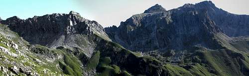
 Balschtespitze as seen from Rotwand ascent
The Hornbach range of the Allgäu mountains is the impressive southernmost subrange of this important part of the Northern Limestone Alps. There are the highest peaks of this wellknown region and – at the same time – most of these peaks are summited rarely.
One of those peaks is Balschtespitze, a widely unknown but nevertheless very interesting peak of Hornbach range. Being one of the neighbours to often crowded Hermann-von-Barth Hütte does not help, the rather uninviting looking south slope with the off-trail normal route and the lack of a clear signpost or marks are the stronghold against too much visitors. If you want to visit a remote summit, e.g. combining it with an interesting two days traverse in this beautiful subgroup, Balschtespitze can be highly recommended. See the Main Route section below for some tip-offs.
Standing between the equally seldom visited Kreuzkarspitze to the east and the Ilfenspitze / Plattenspitze / Wolfebnerspitze to the west, Balschtespitze shows steep rockfaces down into Kreuzkar and Schönecker Kar to the north and a rugged appearance to the south. Impressive Balschteturm, a huge rock spire, stands at the culminating south end of the south arête, high above Balschtekar, south of the summit.
The normal route uses the south slope, starting east of Schönecker Scharte, the main col between Hornbach valley in the north and Lechtal valley to the south. These two valley are dividing Hornbach range (and Balschtespitze) from Allgäu main range and from the Lechtal Alps.
Getting There
 Balschtespitze as seen from Enzensperger Weg
The main trailheads for Balschtespitze are Elbigenalp in the Lechtal valley and Hinterhornbach in the Hornbach valley.
You reach Lechtal valley
Follow Lechtal valley road number 198 from Reutte or from Lech / Warth until you reach Elbigenalp. The trailhead is at the western end of Elbigenalp where the Geierwally parking area is signposted. Leave your car here (2009: free parking).
The village of Hinterhornbach can be reached directly from Lechtal valley road by leaving the road at Martinau or Stanzach in the direction to Vorderhornbach. At Vorderhornbach follow the signposts to Hinterhornbach. The trailhead is at the western end of the little village: go on the road by passing the church and use the first road which branches off to the left and immediately crosses Hornbach creek on a bridge. Behind the bridge is the parking area (2009: free parking).
 Panorama from western Balschtekar: Schönecker Kopf, Scharte, Balschtespitze, Kreuzkarspitze
Main Routes Overview
Elbigenalp ascents
To summit Balschtespitze you have to reach the Enzensperger Weg / trail number 432 / 435 in the center part of Balschtekar.
 Schönecker Scharte Schönecker Scharte |  Balschtespitze south slope Balschtespitze south slope | 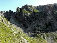 Balschtespitze normal summit route Balschtespitze normal summit route |
From Elbigenalp follow the mountain road to Kasermandl Inn and to the resupply cableway of Herrman-von-Barth Hütte. At the end of this road you have three possibilities:
At the trail junction follow trail 432 in the direction to Schönecker Scharte. Leave this trail where it starts to zigzag up to the col and turn right. Ascend on a barely visible foot path to the steep rocky south slope of Balschtespitze. Climb up the rocks where it is easiest (UIAA grade I) and follow the steep meadow and rock slope up to the summit.
Hinterhornbach ascent
From Hinterhornbach parking area follow trail number 432 into Hornbach valley. Before you cross the Hornbach creek go straight on on a narrow trail which soon zigzags steeply up the north slopes of Hornbach chain and traverses high above Hornbach valley the Faule Wand location. Again there are some steep zigzags up over steep meadows. The trail reaches the huge Schönecker Kar and climbs up this cirque to a notch called Schönecker Scharte. On the south side of the notch the trail descends steeply in the direction of Enzensperger Weg.
To get to the summit leave the descending trail below the steep southern rockface of Schönecker Scharte and traverse some minutes to the left to the beginning of the rocky south slope of Balschtespitze. Climb up the rocks where it is easiest (UIAA grade I) and follow the steep meadow and rock slope up to the summit.
 Balschtespitze as seen from Enzensperger Weg
Tip-offs for several days
Combine Balschtespitze with:
Your overnight stay should be at Herrmann-von-Barth Hüttefort his.
Red Tape & Accommodations
 Balschtespitze (center), Kreuzkatspitze (right)
There are, as far as I know, no special restrictions in this area.
Parking areas should be free (2009).
In Lechtal and Hornbach valley there are all sorts of accomodations: Hotels, Inns, private Bed & Breakfast and Camping areas.
For general infomations please refer to: Lechtal tourist page
More detailed informations about accommodations in the nearest villages can be found on the homepages of
Nearby mountain huts (alpine club or private huts) are:
Gear & Mountain Conditions
 Balschtespitze south arete
Balschtespitze is a summer and autumn hike. As far as I know there are no winter and spring ski hike activities.
It is a strenuous day hike especially from the Hornbach valley trailheads. The summit ascent is off-trail with a lot of steep rock and meadow scramble and some climbing – UIAA grade I.
You need normal hiking gear with good shoes.
Check the current weather here.
Map & Guide Book
 Huge Balschtekar
As map I recommend the detailed Alpenverein map for a better orientation.
Balschtespitze is mentioned in:
Dieter Seibert
Alpenvereinsführer Allgäuer Alpen und Ammergauer Alpen alpin
Bergverlag Rother 2004, 16. Auflage
ISBN-13: 9783763311262 / ISBN-10: 3763311262