
-
 15256 Hits
-
 86.37% Score
-
 22 Votes
|
|
Mountain/Rock |
|---|---|
|
|
47.35450°N / 10.09980°E |
|
|
7322 ft / 2232 m |
|
|
Overview
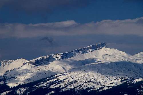 Hoher Ifen and the Gottesacker Plateau seen from Nebelhorn Hoher Ifen and the Gottesacker Plateau seen from Nebelhorn |
When this morning I read the beautiful new Rauheck Page by cjaniesch I wondered that so far only six Allgäu Alps mountains had been posted to SP. One of the most interesting ones, Hoher Ifen, was missing too and so I decided to put an end to this utter misery. Those of you who know my ways know that an Allgäu Alps Group page might be lurking somewhere in the near future.
Even by Allgäu Alps standards Hoher Ifen’s altitude is far from impressive. But given the fact that the surrounding area (see below) is even lower, the mountain is one of the most prominent landmarks of this part of the Austrian – German border region. The summit is a tilted plateau surrounded by a limestone rock face of differing height. The Ifenmauer (the northern rock face) can be scaled over a broad ledge – the normal route - which never exceeds UIAA I.
Gottesacker – God’s Acre
The most interesting feature about the mountain is the surrounding karstic plateau, Gottesacker. I’m not sure if my old pictures tell the true story but the name refers to the moonscape-like look of the plateau – like an eerie graveyard with opened graves.
Hoher Ifen’s summit is the highpoint of this plain, which slants in north-easterly direction towards Kleinwalsertal Valley between 1900m and 2000m elevation. The word “plain” might give the wrong impression – actually Gottesacker is a labyrinth-like structured plateau with deep ravines, sharp-edged limestone crags, crevices and deep caves. Orientation is difficult even in perfect weather since you constantly lose sight of your destination. Reportedly in foggy conditions people have vanished in some of the many crevices. Gottesacker is a nature preserve and a sanctuary for many rare flowers.
IMHO the perfect way to climb the mountain is to start at Rohrmoos Valley, scale the lower and upper Gottesackerwände (beautiful limestone walls) and cross Gottesacker in derection of Hoher Ifen. The hike / climb / scramble is strenuous and I have failed twice to reach my goal. Crossing Gottesacker takes a lot of time, more than you would think. The direct line route is just not possible.
Around 2000 on the eastern slopes of Hoher Ifen at around 1500m a Stone Age dwelling was discovered and meanwhile excavated. It documents the settlement history of this part of the Alps, much like Ötzi did for the Ötztal Alps.
Geographically Hoher Ifen and Gottesacker constitute part of the European Watershed, where water is separated between the North Sea (Rhine River) and the Black Sea (Danube). Hoher Ifen is located directly on the Austrian – German border, in fact the border makes a sharp bend southward just to include it. Speaking of borders things get a little confusing here. You can access Hoher Ifen through the Austrian Kleinwalsertal Valley, which can be reached from Germany only. There is no direct access to the valley across Austrian territory other than climbing the encompassing ridges.
 |  |  |
Getting There
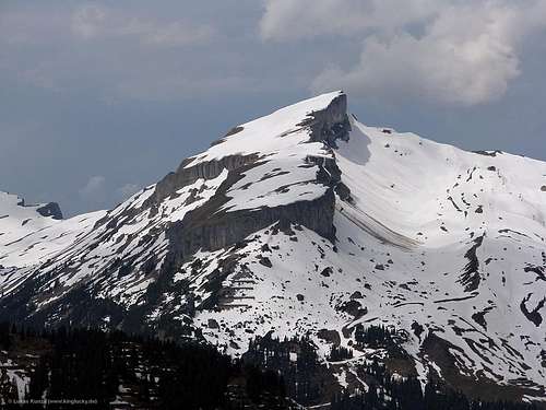 Hoher Ifen seen from Hammerspitze
The closest international airports are at Munich and Stuttgart. Both cities are connected by motorway A8 (notorious for traffic jams). Almost in the middle between the cities at Ulm there is a motorway intersection (Kreuz Ulm) with A7, which you need to drive in southerly direction. At Kempten take A980 west, which ends after a couple of miles/kms where you have to switch to B19 south. The road takes you to Oberstdorf the principal town of this part of Allgäu. Oberstdorf can also be reached by train. See here for the train connections.
Just north of Oberstdorf two roads lead into two valleys which both can serve as trailheads for the ascent of Hoher Ifen. Northernmost is the side road to Rohrmoos Valley, closer to Oberstdorf is B19 (again or still) which leads into Kleinwalsertal Valley. The closest trailhead is at Hirschegg in Kleinwalsertal.
 |  |
Red Tape
Yes, there is red tape on the whole Gottesacker Plateau. It is a nature preserve so anything should be left in place. And don't dump your garbage in one of the crevices or caves!When To Climb
Hoher Ifen can be climbed all year. In summer the best time is between May and October. In winter there is a ski run between Auenhütte and Ifenhütte. The ski lift is operated all year round with breaks in early spring and late autumn. Negotiating the ledges with tour skis might be a little tricky in winter.Accommodation
You can choose between campgrounds, farm holidays, vacation homes and hotel rooms on most of the sites of the Allgäu villages. Here I include the English language sites:Weather Conditions
All of the towns and villages of Allgäu have their web sites, most of them with weather information and live cams. The closest info can be found atwww.kleinwalsertal.de
Mountain Huts
There are three huts which server the Hoher Ifen Area:| Hut | Height | Open | Tel. |
| Schwarzwasserhütte | 1620m | June -mid Oct / Christmas - mid March | +43 5517 30210 |
| Ifenhütte | 1592m | mid June - mid Oct / Christmas - Easter | n.a. |
| Auenhütte | 1275m | All Year | +43 5517 5265 |
Maps 'n' Books
- Maps
- Allgäuer Alpen
Kompass Map WK3
Kompass Verlag
ISBN: 3-85491-005-3
- Oberstdorf, Kleinwalsertal
Kompass Map WK03
Kompass Verlag
ISBN: 3-85491-231-5
- Allgäuer Alpen
- Books
- Hiking
- Allgäu 1
Oberallgäu und Kleinwalsertal
D. Seibert
Rother Verlag
ISBN: 3-7633-4289-3
- Allgäuer Alpen
H. Mayr
Kompass Verlag
ISBN: 3-85491-201-3
- Allgäu 1
- Climbing
- Allgäuer Alpen
D. Seibert
Rother Verlag
ISBN: 3-7633-1126-2
- Allgäuer Alpen
- Hiking