
-
 5074 Hits
-
 80.49% Score
-
 12 Votes
|
|
Mountain/Rock |
|---|---|
|
|
47.41321°N / 10.35063°E |
|
|
Hiking |
|
|
Spring, Summer, Fall, Winter |
|
|
6545 ft / 1995 m |
|
|
Overview
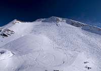
 The Zeiger Ridge seen from Zeigersattel The Zeiger Ridge seen from Zeigersattel |
In summer, Zeiger is little more than an unimportant summit standing above one of the most crowded places of the Allgäu Alps, the Höfatsblick Cable Car Station, end point of the second stage of the three stage Nebelhornbahn cable-car. It is one of the endpoints of a ridge, which runs from Schneck in a sweeping curve towards Zeiger. The mountains on the way are what we call in German "Steilgrasberge" - steep grass mountains - covered with grass with sometimes extremely steep slopes on either side of the ridge. Zeiger follows that pattern though for most part its slopes are not overly steep.
 |  |  |
At nearly 2000m Zeiger itself is rather a ridge than a single summit mountain. It stretches for several hundred metres running from south to north getting ever narrower on the way. The ridge itself is not steep in any way but the farther you get to the north the more exposed it gets. There are three distinct summits, southern, middle and northern one. The southern summit is used for cattle grazing and a low cattle fence marks its highest part. In summer the barbed wire fence keeps away visitors (who anyway rather opt for the more impressive mountains to the south), in winter it is a welcome marker for orientation on the often corniced ridge.
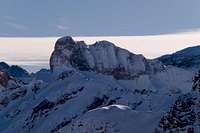
 Looking across the Zeiger Ridge towards Hochvogel
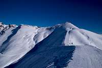
Zeiger - or at least its south summit - is very popular in winter, when a "Winterwanderweg" (winter hiking trail) is maintained from the cable-car to nearby Zeigersattel. The saddle separates Zeiger from Hüttenkopf, nearly reaching the latter's elevation of 1945m. The trail is broad, not ending at the saddle but reaching a few hundred metres beyond. From there the cattle fence marks the shortest and easiest ascent to Zeiger's south summit along its broad west ridge. Ridge and fence turn northward on the summit, winding along the top of Zeiger in northern direction. While the west face remains relatively shallow - a popular offroute skiing slope - the east slopes are steep and often carry cornices.
 Zeiger in front of Nebelhorn Zeiger in front of Nebelhorn | ||
 Diedamskopf Diedamskopf |  Höfats Höfats |  Hoher Ifen Hoher Ifen |
 Schneck Schneck |  Großer Krottenkopf Großer Krottenkopf |  Großer Seekopf Großer Seekopf |
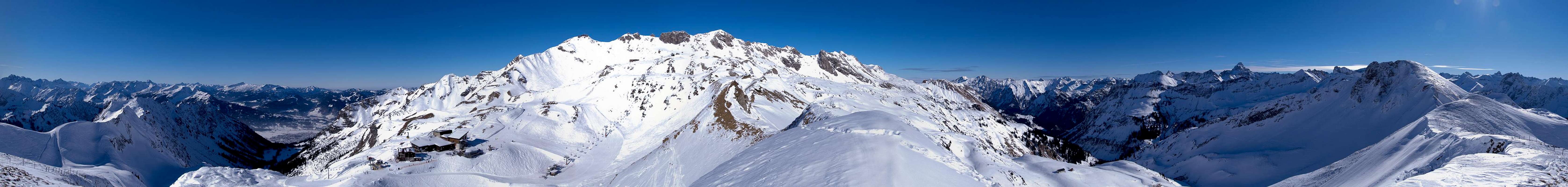
The highest summit is right above the cable-car station Höfatsblick and is separated from the steep north summit by a pronounced saddle. Zeiger, thanks to its central location in the Daumen Group is a good lookout point even though it lacks elevation and in the south views are partially blocked by the higher Großer Seekopf. The vista includes almost all of the Allgäu Alps together with parts of Lechquellengebirge and Beregenzerwald Gebirge.
360° Summit Panorama
  |
Getting There
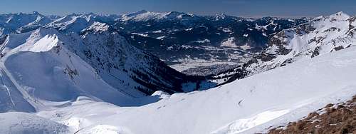 Looking down through the Seealpe Valley to Oberstddorf 1000m beneath the Zeiger summit
Zeiger can be reached in the dead end Iller Valey in the Allgäu Alps. The shortest ascent includes a trip with the Nebelhornbahn Cable-Car to the Höfatsblick middle station from Oberstdorf.
The closest airports are at Stuttgart and Munich, both cities being connected by motorway A8.
- Take motorway A8 to the intersection Kreuz Ulm-Elchingen.
- Turn onto motorway A7 south, direction Kempten and Füssen.
- At the intersection Dreieck Allgäu switch to A980.
- A few km later turn onto B19, direction Oberstdorf.
- Follow the signs for Nebelhornbahn.
Red Tape
The whole Daumen Group is part of the natural preserve Naturschutzgebiet Allgäuer Hochalpen. The usual rules apply - don't disturb wild animals, don't collect any plants, stay on the marked trails. Dogs should be kept on leash. These rules seem to be rather outdated when you see the brouhaha around the Nebelhornbahn cable-car stations. But remember, that parts of the group still are remote and can be solitary.Parking lots: you have to pay for almost all parking lots in Oberstdorf. However, the parking fee is partly refunded if you take the cable-car. Still, the Nebelhornbahn cable-car is very expensive, especially if you want to go all the way to the top. Out of winter season all Oberstdorf cable-cars are included in the Oberstdorf-Karte, which is often included in accommodation.
Accommodation
You can choose between campgrounds, farm holidays, vacation homes and hotel rooms on most of the sites of the Allgäu villages. Oberstdorf is most expensive so the short list includes the villages to the north. Good starting points are:Weather Conditions
 Changing weather conditions seen from Zeiger
Maps & Books
Maps
- Allgäuer Alpen / Kleinwalsertal
1:50000
Kompass Map WK 3
Kompass Verlag
ISBN: 3-85491-005-3
- Alpenvereinskarten : Allgäu-West
1:25000
Deutscher Alpenverein
ISBN: 3928777130
Books
- Allgäuer Alpen und Ammergauer Alpen Alpin
D. Seibert
Alpenvereinsführer
Rother Verlag
ISBN: 3-7633-1126-2
- Allgäu 1 - Oberallgäu und Kleinwalsertal
D. Seibert
Rother Verlag
ISBN: 3-7633-4289-3