
-
 1301 Hits
-
 83.1% Score
-
 16 Votes
|
|
Mountain/Rock |
|---|---|
|
|
45.92639°N / 7.47710°E |
|
|
Mountaineering |
|
|
11384 ft / 3470 m |
|
|
Overview
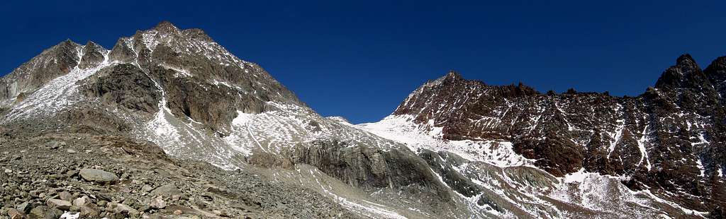
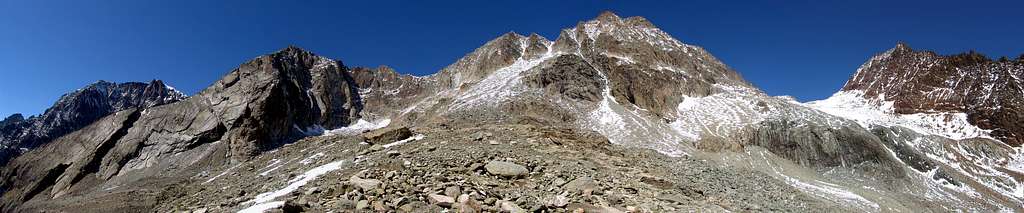
An obvious, a small triangular pyramid as well as a very important topographical node as it is the meeting point of three valleys: the Comba (Basin) della Sassa to the Southwest, the Combe des Lacs to the South and the Comba d'Orein or d'Oren to the Southeast; the same are distinguished by the Glacier Oriental de la Sassa, by Lac Mort and Lac Long and by the Bas (Low) Glacier d'Oren. Very elegant when viewed from the East, it loses momentum and beauty on the other two slopes separated from each other by the three basic ridges: the NW Crest on the Colle della Sassa (3.259m), the SW Crest that descends above the rocky Col Bovet (3.245 meters approximately) and the Crest SE which heads towards the Col des Lacs about 3.310 meters; these three crests include as many walls: the NW Face above the Glacier Oriental de la Sassa and the homonymous bivouac (2.973m), the Parete South above Lake Morto (2.843 m) and the great Wall E-NE which falls above the Bas Glacier d'Oren reaching it at an altitude of approximately 2.810 meters. To the North extends the mountain range which, after the Colle della Sassa, forms Mont Dragon-Grand-Blantsin better known as Grand Becca Blanchen (3.679/80m), Mont de la Ceingla or La Sengla (3.714m), the two Becche d'Oren, L'E'veque, la Miter to finish, completely in Switzerland, with the Mont Collon (3.637m); the two chaines rise respectively to the Southwest and Southeast rispectively to the Becca Bovet (3.443m) and to the Aiguille Rouge des Lacs and Aiguille Blanche des Lacs, with the latter being the highest point in the "Zona dei Laghi" (Lakes Area). Sparsely frequented peak due to the long approaching ones but, above all, more beautiful to see than to climb as it is made up of rock that is not always good and, in some cases, definitely bad and dangerous; instead it turns out to be an excellent vantage point, even if closed to the North by the mass Gr. Becca Blanchen/Sengla.
Evidente, piccola piramide triangolare nonché nodo topografico molto importante poiché punto di incontro di tre valloni: la Comba della Sassa a Sudvest, la Combe des Lacs a Sud e la Comba d'Orein o d'Oren a Sudest; le stesse sono contraddistinte dal Glacier Oriental de la Sassa, dal Lac Mort e dal Lac Long e dal Bas Glacier d'Oren. Molto elegante se vista da Est, perde in slancio e bellezza sugli altri due versanti separati tra loro dalle tre creste di base: la Cresta NO sul Colle della Sassa (3.259 m), la Cresta SO che scende sopra il roccioso Col Bovet (3.245 metri circa) e la Crest SE che si indirizza verso il Col des Lacs 3.310 metri circa; queste tre creste comprendono altrettante pareti: la Parete NO al di sopra del Glacier Oriental de la Sassa e l'omonimo bivacco (2.973 m), la Parete Sud al di sopra del Lago Morto (2.843 m) e la Parete E-NE che precipita sopra il Bas Glacier d'Oren raggiungendo il medesimo a quota 2.810 metri circa. A Settentrione si estende la catena montuosa che, dopo il Colle della Sassa, forma il Mont Dragon-Grand-Blantsin meglio conosciuta come Grand Becca Blanchen (3.679/80 m), il Mont de la Ceingla ovvero La Sengla (3.714 m), le due Becche d'Oren, L'E'veque, la Mitre per terminare, completamente in Svizzera, con il Mont Collon (3.637 m); a Sudovest e Sudest si ergono rispettivamente i due gruppi della Becca Bovet (3.443 m) e dell'Aiguille Rouge des Lacs e dell'Aiguille Blanche des Lacs, con questa ultima che risulta essere il punto più elevato della "Zona dei Laghi". Cima scarsamente frequentata a causa dei lunghi avvicinanti ma, soprattutto, più bella da vedere che da scalare essendo costituita da roccia non sempre buona ed, in alcuni casi, decisamente cattiva e pericolosa; invece risulta essere quale ottimo punto panoramico, anche se chiusa verso Nord dalla massa Gr. Becca Blanchen/Sengla.
First Ascents
- First on the summit: Ettore Canzio and Felice Mondini withthe Mountain Carrier Giacomo Noro, (Aug 28th, 1897); in ascent from Comba de la Sassa and homonym pass.
- In winter: unknown.
- NO Crest (Standard Route): Ettore Canzio and Felice Mondini with the Mountain Carrier Giacomo Noro, (Aug 28th, 1897); in ascent from Comba de la Sassa and homonym pass.
- SO Ridge (from Col Bovet): Aldo Bonacossa and Benedetto Salvi Cristiani, (Apr 29th, 1917).
- SE Crest (from Col des Lacs): Marcel Kurz with Mountain Guide Cyrille Favre, (Sep 07th, 1923).
- NO Face: Osvaldo Cardellina, Sandrino Casalegno and Giuseppe Lamazzi, (Oct 05th, 1986), from Comba du Grand Chamin and Comba de la Sassa.
- E-NE Wall: Osvaldo Cardellina, solo, (Jun 16th, 2001); in ascent from Comba d'Oren, Lac d'Orein.
- Southern Wall: Osvaldo Cardellina, solo, (Nov 21th, 2002); in ascent from Place des Moulins, Plan Vaùon, Lakes Area.
Getting There
BY CAR:
- From Torino, Milano, etc: Motorway A5. Exit at Aosta Est.
- From Switzerland: through the Grand Saint Bernard Tunnel or the namesake pass.
- From France: through the Mont Blanc Tunnel or Petit Saint Bernard Pass. It is not necessary to take Motorway A5: you can drive on SS.26, in the direction of Aosta.
BY PLANE:
- Aeroporto "Corrado Gex" Saint Christophe (Aosta).
Approach
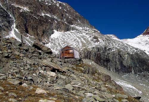
The ancient path for the double Vallone, first of Chamein and then of the Sassa in practice, after the construction of the farm road starting from Chamen (1.710m), has fallen into disuse; for which this last dirt road is used today, except for short cuts. Through this you reach the Alpe Grand Chamen (2.010m) and then that of Crottes (2.191 m; 1h'15), where it ends and where the remains of paths n° 3 and n° 6 also end. Also the Vallone di Grand Chamen, since the valley, turning North-east, takes the name of Vallone della Sassa. In this section, the trail n° 6. with rudimentary wooden walkways as well as passing near the ruined alp 2.521/5 meters (0h'45), leads to the steep moraine that leads to the Bivacco della Sassa (2.973 m; 3h'00/3h'30).
L'antico sentiero per il doppio Vallone, dapprima di Chamein e poi della Sassa in pratica, dopo la costruzione della strada poderale con partenza da Chamen (1.710 m), è andato in disuso; per la quale cosa oggi si utilizza questa ultima, tranne brevi scorciatoie. Tramite questa si raggiunge l'Alpe Grand Chamen (2.010 m) ed in seguito quella di Crottes (2.191 m; 1h'15), dove la stessa finisce e dove terminano anche i resti dei sentieri n° 3 e n° 6. Da questo punto termina anche il Vallone di Grand Chamen, poiché la vallata, svoltando a Nordest, assume il nome di Vallone della Sassa. In questo tratto si evidenzia ancora il sentiero n° 6 che, guadando un paio di volte il Torrent de Grand Chamin o Chamen sopra delle rudimentali passerelle in legno nonché passando nei pressi dell'alpe diroccata 2.521/5 metri (0h'45), si indirizza alla ripida morena che conduce al Bivacco della Sassa (2.973 m; 3h'00/3h'30).
Route
From the small Bivacco della Sassa (2.973m) first climb to the left (North) through snow or detrital slope paying attention to the possible falling of stones from the Piccola Becca Blanchen (3.574m) reaching the snowy plateau of the Sassa Glacier at an altitude of 3.100/3.150 meters about; continue in the middle of the same which guarantees from the possible fall of stones both from the Grand Becca Blanchen (3.680m) and from the rocky coast that descends from the Becca des Lacs towards the Col Bovet (about 3.230 meters), but paying close attention to the existing crevasses. In short and without difficulty you reach the wide and rounded saddle of Colle della Sassa (0h'45/1h'00). From this last climb the North-Northwest Crest which acts as a watershed between the Glacier Oriental de la Sassa (West) and the Bas Glacier d'Orein or d'Oren (East), as well as a divider between the respective valleys; the same is made up of fairly steep rocks and in many places with fair exposure (pay attention in some parts and avoid side bypasses, useless and dangerous), but not difficult. Alternating friable rocks with slightly better rocks and some short sections in snow, it is quite easy to reach the Summit (3.470m; 0h'45/1h'00).
 |
 |
 |
 |
 |
Dal Bivacco della Sassa (2.973 m) salire dapprima verso sinistra (Nord) tramite nevati o pendio detritico facendo attenzione alla possibile caduta di pietre dalla Piccola Becca Blanchen (3.574 m) raggiungendo il pianoro innevato del Ghiacciaio della Sassa a quota 3.100/3.150 metri circa; si continua nel mezzo dello stesso che garantisce dalla possibile caduta di pietre sia dal Grand Becca Blanchen (3.680 m) che dalla costiera che scende dalla Becca des Lacs verso il Col Bovet (3.230 metri circa), ma facendo bene attenzione ai crepacci esistenti. In breve e senza difficoltà si raggiunge il largo ed arrotondato Colle della Sassa (0h'45/1h'00). Da questo ultimo salire la Cresta Nord-nordovest che funge da spartiacque tra il Glacier Oriental de la Sassa (Ovest) ed il Bas Glacier d'Orein o d'Oren (Est), nonché da divisorio tra i rispettivi valloni; la stessa é formata da rocce abbastanza ripide ed in molti tratti con discreta esposizione (prestare attenzione in alcune parti ed evitare inutili nonché pericolosi aggiramenti laterali), ma non difficili. Alternando rocce friabili a rocce appena più buone ed alcune brevi sezioni in neve, abbastanza agevolmente si raggiunge la Sommità (3.470 m; 0h'45/1h'00).
Difficulty
From F+ to PD-/PD.
Da F+ a PD-/PD.
Gear
Helmet, rope, ice-axe and crampons.
Elmetto, corda, piccozza e ramponi.
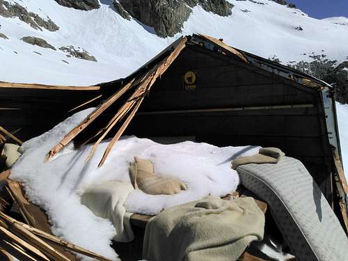
Huts
ATTENTION: the bivouac was destroyed by an avalanche in the winter of 2019-2020.
ATTENZIONE: il bivacco è stato distrutto da una valanga nell'inverno 2019-2020.
Remember that free camping is forbidden (except for emergency reasons, over 2.500m, from darkness until dawn).
Mountain Conditions
- You can get meteo information at the official site of the Regione Valle d'Aosta:
- Valle d'Aosta Meteo
Webcam
- WEBCAM on Aosta Valley:
- Webcam
Books and Maps
BOOKS:
- "Guida delle Alpi Occidentali", di Giovanni Bobba e Luigi Vaccarone C.A.I. Sezione di Torino Volume II (parte II), 25 Maggio 1896.
- "Guida dei Monti d'Italia-Alpi Pennine" (Vol.I°) di Gino Buscaini-Club Alpino Italiano/Turing Club Italiano, Luglio 1971 (in Italian).
- "Diari Alpinistici" di Osvaldo Cardellina e Indice Generale accompagnato da Schedario Relazioni Ascensioni 1964-2019 (unpublished).
- "Guida della Valpelline" de l'Abbè Joseph-Marie Henry - Societè Editrice Valdotaine 1925 II Edition e Collana Reprint Musumeci (1986).
- "Rifugi e bivacchi in Valle d'Aosta" di Cosimo Zappelli aggiornata da Pietro Giglio. Musumeci Editore, Luglio 2002 (in Italian).
 |
 |
 |
MAPS:
- Kompass "Breuil Cervinia Zermatt" Sentieri e Rifugi Carta turistica 1:50.000.
- L'Escursionista "Valpelline, Saint Barthélemy" (carta n° 6) 1:25.000.
- I.G.C. Istituto Geografico Centrale "La Valpelline, Ollomont, Saint Barthélemy", (carta n° 115) Map1:30.000.
- Carta Nazionale Svizzera "Foglio Valpelline" 1:50.000.
Important Information
- REGIONE AUTONOMA VALLE D'AOSTA the official site.
- FONDAZIONE MONTAGNA SICURA Villa Cameron, località Villard de la Palud n° 1 Courmayeur (AO) Tel: 39 0165 897602 - Fax: 39 0165 897647.
- SOCIETA' DELLE GUIDE DELLA VALPELLINE Etroubles-Strada Nazionale, n° 13 - Tel +39 0165 78559 - Valpelline-Loc Capoluogo, n° 1 - Tel +39 0165 713502 (AO) Italia.
- A.I.NE.VA. (Associazione Interregionale Neve e Valanghe).
Useful numbers
- Protezione Civile Valdostana località Aeroporto n° 7/A Saint Christophe (Ao) Tel. 0165-238222.
- Bollettino Meteo (weather info) Tel. 0165-44113.
- Unità Operativa di Soccorso Sanitario Tel. 118.