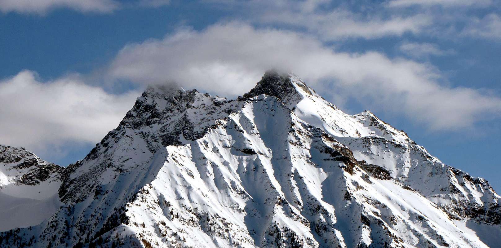
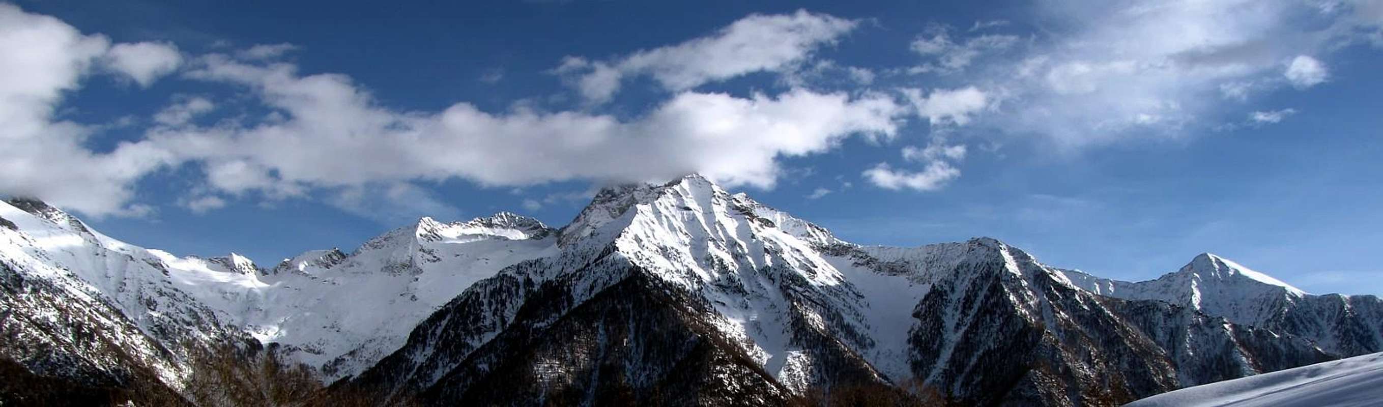
This beautiful pyramid is like the fifth elevation for altitude in the long watershed between the Valleys of Ayas and Lys or Gressoney, that the Monte Rosa mountain range reaches between the Commons of Verrès and Pont Saint Martin the Central Valley of Dora Baltea. In fact from Punta Perazzi (3.801m), where it concludes the real Central Group of Monte Rosa, we find only the Rothorn (3.152m), the Testa Grigia (Gray Head) or Groabhopt (3.316m), the adjacent Monte Pinter (3.137m), and the Corno Vitello (Horn Calf; 3.057m) with a height above. But, beyond these annotations statistical-topographic, there is to be observed how the same is highlighted at the highest levels in the observations aesthetic, while in those mountaineering definitely apparent as the mountain with the higher number of ways both as regards the amount that the quality thanks to a beautiful and compact rock mainly composed of gneiss. In fact, including the "normal route" through the sharp and exposed Western Ridge that separates it from Torché sister Becca (3.016m) with which constitutes the so-called "Dames de Challand", none of the climbing routes is simple or easy. Inserted between Monte Voghel (2.925m) and Becca Torché (3.016m), is formed by three ridges (in addition to this the Eastern and South) and as many walls, between which the one facing the North is clearly divided into two distinct parts by a marked rocky Northern Spur, comes as grim and impenetrable mountains on all sides, although its ascent is less difficult than expected, but still very exposed. Beautiful shots of eye towards North to the Testa Grigia and Monte Rosa, while to the South, the view extends to the Alps Graian.
Questa bella piramide risulta come la quinta elevazione per altitudine nel lungo spartiacque tra le Valli di Ayas e del Lys o Gressoney, che dalla Catena del Monte Rosa raggiunge tra i Comuni di Verrès e Pont Saint Martin la Valle Centrale della Dora Baltea. Infatti dalla Punta Perazzi (3.801 m), dove si conclude il vero e proprio Gruppo Centrale del Rosa, riscontriamo esclusivamente il Rothorn (3.152 m), la Testa Grigia o Groabhopt (3.316 m), l'attiguo Monte Pinter (3.137 m), ed il Corno Vitello (3.057 m) con un'altezza superiore. Ma, al di là di queste annotazioni statistico-topografiche, vi è da osservare come la medesima si evidenzi ai massimi livelli nelle osservazioni estetiche, mentre in quelle alpinistiche sicuramente risulta come la montagna con il maggiore numero di vie sia per quanto concerne la quantità che la qualità anche grazie ad una bella e compatta roccia prevalentemente composta da gneiss. Infatti, compreso la "Via Normale" tramite l'affilata ed esposta Cresta Occidentale che la separa dalla gemella Becca Torché (3.016 m) con la quale costituisce le cosiddette "Dames de Challand", nessuna delle sue vie di salita si presenta semplice o facile. Inserita tra il Monte Voghel (2.925 m) e la Becca Torché (3.016 m), risulta formata da tre creste (oltre a questa quella Orientale e la Sud) ed altrettante pareti, tra le quali quella rivolta a Settentrione viene nettamente divisa in due ben distinte parti da un marcato sperone roccioso Settentrionale, si presenta come montagna arcigna ed ostica da ogni lato, anche se la sua ascensione risulta meno difficile del previsto, ma comunque sempre molto esposta. Ottimo panorama verso Nord sulla Testa Grigia ed il Monte Rosa, mentre verso Mezzogiorno la vista spazia sulle alpi Graie.
First Ascents
First ascent on the summit: Agostino Ferrari with Mountain guide Bisler.
First ascent in winter: Ezio Capello and Franco Ribetti, Dec. 31th, 1956.
First traverse Becca Torché-Becca di Vlou-M. Voghel (from Dondeuil to Chasten Passes): V. Fonte, P. Viglino and A. Viriglio, Jul. 15th, 1917.
North-northwest Edge: Franco Gatta and Gian Luca Ferretti, Aug. 30th, 1925.
North-northwest Wall: Dino e Jean Charrey, Aug. 19th, 1928.
North Eperon: Ottavio Bastrenta, lone, Aug. 06th, 1955.
Northeast Edge and North Eperon: E. Capello, F. Demaestri, F. Ribetti and G. Ribetti, Jul. 14th, 1957.
Northeast wall: Ottavio Bastrenta and Ezio Capello, Aug. 10th, 1956.
Eastern crest: Unknown.
Southeast Face: Michele Baratono and Giuseppe Girodo, Jun. 16th, 1929.
Southeast Face (Direct Variant): Ottavio Bastrenta and Ezio Capello, Aug. 31th, 1954.
Southern Ridge: Carlo Biglia, Roberto Boggio and Piero Zanetti, Jul. 24th, 1924. Second: Ottavio Bastrenta and Ezio Capello, Aug. 28th, 1955.
Southwest Face (Dihedral): Ezio Capello and G. Ribetti, Aug. 23th, 1958.
Southwest Face (little left Couloir): Osvaldo Cardellina, Christian Cardellina, Danilo Garzotto and Giuseppe Lamazzi, Sep. 16th, 1995.
Getting There
BY CAR:
From TORINO, MILANO, etc: Motorway A5. Exit at IVREA or Quincinetto (PIEDMONT)
From FRANCE: through the Mont Blanc Tunnel to Entrèves/Courmayeur. By Little Saint Bernard Pass, closed since November until half May to La Thuile Valley - Pré Saint Didier - Aosta - Pont Saint Martin - Issime Municipalities. It is not necessary to take Motorway A5: you can drive on SR.26, in the direction of AOSTA - IVREA - TURIN.
BY PLANE:
Aeroporto "Corrado Gex" Saint Christophe (Aosta).
Approachs and Route
Approach through Valbona and Dondeuil Eastern Valleys: reached Issime (953/80m; the Church of San Giacomo) with a short detour from the Regional Road for the Gressoney Valley, take the path n° 1/Via Alpina that rises to the West-northwest in the direction of the Valbona Vallon. The same, after a first series of hairpin bends reaches Santa Margherita, where comes the farm road. A long diagonal passing through the Alps Zeuin, Lamatta (1.787m), vain, Vieukie, Methia, Mongiovetta salt reaching the same in succession to reach after the Alpe di Mounes Dèsott or Lower (+; 2.008m; Chapel of "Madonna della Neve. From the Valley of Valbona and the Western Ridge: always coming from Issime and with the same path n° 1/Via Alpina, or with the two adjacent n° 1C and unnumbered more towards the South, you reach the Alp Munes Superior. From this a track, first in the North to Alp Vlou Bottom (2.215m) and then bearing to the Upper West (2.363m; E/F; 1h'00), located on the slopes of a small narrow vallon between Becca Vlou (West) and Becca Torché. From this, content from the Southern Ridges Torché and Vlou, no trail and nor trace, but with somewhat laborious path through steep moraine and overlapping blocks, back to the above and close Saddle about 2.895/900 meters with the Normal Route for Becca Vlou (at the beginning of the season the presence of snow fields at the top; EE/F+; 1h'20 by the upper alp). Climb the Ridge Eastern, short, sharp and exposed on both sides and formed from plates of good rock (I°+/II°-) arriving in the final part reaching, through rocks easier but often covered with debris and grass, the aerial Summit. Short but always delicate ascent and much exposed (A/from PD- to PD; 1h'00 by the saddle).
Avvicinamento tramite i Valloni di Valbona ed Orientale del Dondeuil:raggiunto il Comune di Issime (953/80 m; Chiesa di San Giacomo) con una breve deviazione dalla Strada Regionale per la Valle di Gressoney, prendere il sentiero n° 1/Via Alpina risalente ad Ovest-nordovest in direzione del Vallone di Valbona. Lo stesso, dopo una prima serie di stretti tornanti raggiunge Santa Margherita, dove arriva anche la strada poderale. Un lungo diagonale che passa per le Alpi Zeuin, Lamatta (1.787 m), Invan, Vieukie, Methia, Mongiovetta sale raggiungendo le medesime in successione per raggiungere in seguito l'Alpe di Mounes Dèsott od Inferiore (+; 2.008 m; Cappella della "Madonna della Neve"). Dal Vallone di Valbona e la Cresta Ovest: sempre arrivando da Issime e con il medesimo sentiero n° 1/Via Alpina, oppure con gli adiacenti n° 1C e non numerato più verso Mezzogiorno, si raggiunge l'Alpe di Munes Superiore. Da questa una traccia dapprima a Settentrione raggiunge l'Alpe di Vlou Inferiore (2.215 m) e poi, piegando ad Occidente quella Superiore (2.363 m; E/F; 1h'00), collocata alle pendici di uno stretto valloncello tra Becca di Vlou (Ovest) e Becca Torché. Da questo, contenuto dalla Cresta Sud della Torché e Meridionale della Vlou, risalire senza sentiero e neppure tracce ma con percorso alquanto faticoso tramite ripida morena e blocchi sovrapposti verso la soprastante e ristretta Sella 2.895/900 metri circa con la Cresta Orientale per la Becca di Vlou (ad inizio di stagione presenza di nevai nella parte più elevata; EE/F+; 1h'20 dall'alpe superiore). Salire la Cresta Occidentale, breve, affilata ed esposta su entrambi i lati e formata da placche di buona roccia (I°+/II°-) raggiungendo nel finale, tramite rocce più facili ma spesso ricoperte da detriti, l'aerea Vetta. Salita breve ma sempre delicata e molto esposta (A/ da PD- a PD; 1h'00 dalla sella).
Difficulty
The route can be classified as E/F or EEA/F+ (Experts Hikers and Mountaineers).
L'itinerario è da classificare in EEA/F+/PD-/PD (Escursionisti Esperti od Alpinisti).
Equipment
For High Hiking gear, but better if with rope.
Da Alto Escursionismo, meglio se con corda.
Campings
Remember that free camping is forbidden (except for emergency reasons, over 2.500m, from darkness until dawn).
Mountain Conditions
You can get meteo information at the official site of the Regione Valle d'Aosta:
Parents refers to a larger category under which an object falls. For example, theAconcagua mountain page has the 'Aconcagua Group' and the 'Seven Summits' asparents and is a parent itself to many routes, photos, and Trip Reports.

 4331 Hits
 85.87% Score
 21 Votes