La montagna chiama i suoi figli, ed essi rispondono fedelmente al suo appello…
Osvaldo Cardellina, Diario alpinistico, 1964-65
Page texts: @ OsvaldoCardellina"Osva", passed away on May 2, 2022. Page owners: Christian Cardellina e Osvaldo Cardellina. Any updates from September 12, 2022: Antonio Giani, page administrator, friend and climbing companion.
Testi della pagina: @ OsvaldoCardellina "Osva", scomparso il 2 maggio 2022. Proprietari pagina:Christian Cardellina e Osvaldo Cardellina. Eventuali aggiornamenti dal 12 settembre 2022: Antonio Giani, amministratore della pagina, amico e compagno di salite.
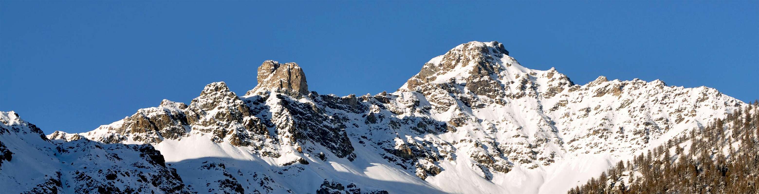
Overview below Mont Faroma
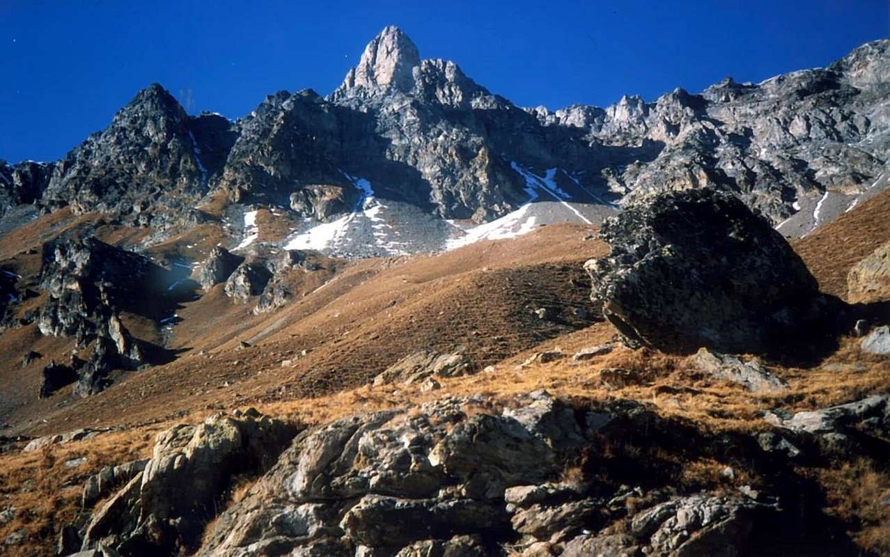
Although this mountain is part of the "collection" of the mountains "desparecidos" or not known; than the others we have discussed, this at least has a name even though it certainly does not appear to be neither popular nor very busy, despite that it is in plain view looking from the entrance to the Valley of Saint Barthélemy. This is actually a great shoulder suffered in the Southeast of Mont Pisonet (3.205m), where this directs a dividing ridge between this valley and the much more famous Cuney Walloon with its famous Sanctuary (+; 2.430m); the partition reaches the neighbors Hills Chaleby (2.653m), Salvé (2.569m) to finally stand up and end with a round Mont Morion (2.709m), just above Lignan with its Astronomical Observatory (+; 1.633m). All into Group of Mount Faroma (3.073m), which rises and towering opposite there, like a great Gothic cathedral. Easy to climb, gives limited views just because of the mass of the same, as well as the ridge dividing the valley from that of Valpelline that continues towards the Northeast until you reach the beautiful pyramid of Becca of Luseney (3.504m), at the end of this valley. Console themselves with local views and, in the distance to the South, but not excessively, on Groups Avic, Glacier, Tersiva and Emilius. Also unusual views of the mountains in the foreground seeds unknown (Punta Montagnayes and Tre Summits of Arbière) in the stretch of the watershed ridge that reaches from Faroma to Becca del Merlo and from this the most well-known Luseney; more in the Northeast and to Switzerland and to the Regal Piedmont give the impression of "getting away" Matterhorn and Monte Rosa, as if to distance himself from a "class" so miserable and forgotten by God and by men ...
Anche questa montagna fà parte di quella "collezione" di montagne "desparecidos" o per nulla conosciute; rispetto all'altre che abbiam trattato, questa almeno un nome lo possiede anche se sicuramente non risulta essere né famosa e tanto men molto frequentata, nonostante si trovi in bella vista guardando dall'ingresso in Valle di Saint Barthélemy. Trattasi in realtà d'una grande spalla subito a Sudest del Mont Pisonet (3.205 m), ove questo indirizza una cresta spartiacque tra la suddetta valle ed il ben più famoso Vallone del Cuney col suo rinomato Santuario (+; 2.430 m); il divisorio raggiunge i vicini Colli di Chaleby (2653m) e du Salvè (2.569 m) per infine rialzarsi e concludersi con il tondeggiante Mont Morion (2.709 m), proprio al di sopra di Lignan con il suo Osservatorio Astronomico (+; 1.633 m). Il tutto nel Gruppo del Monte Faroma (3.073 m), che s'alza troneggiante lì dirimpetto, a guisa di grande cattedrale gotica, soprattutto in inverno allorché assume grand'aspetto himalayano con le sue creste "fumanti" di neve contro il cielo. Di facile ascensione, concede viste limitate proprio a causa della massa dello stesso, nonché della cresta divisoria questa valle da quella di Valpelline proseguente in Nordest insino a raggiungere la bella piramide della Becca di Luseney (3.504 m), al termine della valle. Consolarsi con viste locali ed, in lontananza a Sud ma non eccessivamente, sui Gruppi d'Avic, Glacier, Tersiva ed Emilius. Inoltre vedute inconsuete in primo piano su montagne semisconosciute (Punta Montagnayes e tre Cime di Arbière) nel tratto di cresta spartiacque che dal Faroma raggiunge la Becca del Merlo e da questa la ben più conosciuta Luseney; più a Nordest dan l'impressione d'"allontanarsi" Cervino e Monte Rosa, quasi a voler "prender distanze da sto basso e miserevol ceto", sconosciuto ai più ed apparentemente anche da Dio abbandonato, fuggendo verso Isvizzera e Regal Piemonte ...
First Ascents
On the Summit: Unknown. In winter: Unknown.
South-southeast Crest (Standard Route from Chaleby Hill): Unknown. South-southeast Crest (Integral Route): Osvaldo Cardellina, Mario David and Danilo Garzotto; November 08th, 1986, in ascent towards Mont Pisonet through Southeast Ridge round trip.
South Face: Osvaldo Cardellina, Mario David and Danilo Garzotto; November 08th, 1986, in descent.
North Slope to Carving about 2.930/5m and West-northwest Crest in final part: Unknown.
Getting There
BY CAR:
From TORINO, MILANO, etc: Motorway A5. Exit at IVREA, Quincinetto (PIEDMONT), Pont Saint Martin, Verrès, Châtillon/Saint Vincent an Aosta East (Nus).
From Courmayeur-Mont Blanc to Morgex Commune with SS.26; font this with Motorway A5. Exit at Aosta West (Aymavilles) or Aosta East (Nus). State Road
From IVREA Town: in West to Pont Saint Martin, Donnas, Verrès, Arnad, Montjovet, Hone, Saint Vincent, Châtillon, Nus Municipalities, through SS.26.
From Courmayeur Resort: in East to Pré Saint Didier, Morgex, La Salle, Saint Pierre, Sarre, Aosta, Nus Communes, through SS.26.
From FRANCE: through the Mont Blanc Tunnel to Entrèves-crossroads to Vény/Ferret Valleys - Mountain Guides of Courmayeur - La Saxe Rock Gym - Courmayeur. By Little Saint Bernard Pass, closed since November until half May to La Thuile Valley - Pré Saint Didier - Courmayeur. It is not necessary to take Motorway A5: you can drive on SS.26, in the direction of AOSTA - IVREA - TURIN.
BY PLANE:
Aeroporto "Corrado Gex" Saint Christophe (Aosta).
SPECIFIC ROAD:
From Nus, with regional Road, towards Marsan (699m), Petit Fénis (939m), Blavy (1.056m), Val Dessous (1.173m) and Dessus (1.268m), Les Fabriques (1.411m), Issologne (1.514m) to Lignan-Saint Barthélemy (+; 1.633m; Astronomical Observatory), in the Center of Saint Barthélemy Valley.
Itinerary and APPROACH
From Aosta East exit of the motorway, follow along the Regional Road towards Saint Barthélemy Valley up to the Lignan Village (+; 1.633m; parking).
Trough Brévaz Vallon to Chaleby Hill (2.653m).
APPROACH A) - from parking by this hamlet (Astronomical Observatory), climb towards the North through the path n° 10B/11 to Place Damon Pasture (1.910 m); here, leaving the branching to the right (East) to the Alp Fontane, most continue to the North-northwest, reaching first the private dirt road that comes from Alp Chaleby (1.952m) to reach the next Champanement (2.330m). Continuing in the primary direction to reach the path of Alta Via number 1 in altitude 2.650 meters around and with this, turning decidedly to the East-southeast, to get to Plan Piscina (2.544m; numerous sources) and in a short time to the immediately overlying Chaleby Hill (2.653m; 2h'15/2h'30).
Towards Fontaney Vallon to Salvé Hill (2.569m).
APPROACH B) - from the junction at Place Damon, left in left (West) to Champanement Pasture through the previous path, instead continue to the right path n° 11 to Alp Fontane (2.088m); * arrival of dirt road from Lignan-Plaisance-Larset) and from this, always with direction to the North after a brief tour of seeds round, reach the next Tsa Fontaney (2.307m). Leaving the East Alpage of Chavalary (2.160m; ** the same comes a farm road from Lignan-Larset), into a small vallon at the foot of Western Slope of Mount Morion and, via a short steep climb a little more, get to the Col du Salvé, with whom he quickly connect to the Chalaby Hill (2.569m; 2h'30/2h'45). *** From these two hills, also, you can get off and walk (easy trail with a passage-equipped) through the alp and neighbor Sanctuary of Cuney(+; 2.653 meters).
Dall'Uscita dell'Autostrada Aosta Est seguire la Strada Regionale che, attraverso la Valle di Saint Barthélemy, risale fino alla Frazione di Lignan (+; 1.633 m; parcheggio).
Tramite il Vallone di Brévaz al Colle di Chaleby (2.653m).
AVVICINAMENTO A) - dal parcheggio di questo villaggio salire verso Nord tramite il sentiero n° 10B/11 fino all'Alpe Place Damon (1.910 m); qui, abbandonando la ramificazione a destra (Est) per l'Alpe Fontane, continuare più verso Nord-nordovest raggiungendo dapprima la strada poderale proveniente dall'Alpe Chaleby (1.952 m) per raggiungere quella successiva di Champanement (2.330 m). Continuando nella direzione primaria raggiungere il sentiero dell'Alta Via numero 1 a quota 2.650 metri circa e con questa, volgendo decisamente ad Est-sudest, arrivare a Plan Piscina (2.544 m; sorgenti varie) ed in breve tempo al subito soprastante Colle di Chaleby (2.653m; 2h'15/2h'30).
Attraverso il Vallone di Fontaney al Col du Salvé (2.569m).
AVVICINAMENTO B) - dal bivio di Place Damon, abbandonato a sinistra (Ovest) il precedente sentiero verso Champanement, continuare invece a destra con il sentiero n° 11 verso l'Alpe Fontane (2.088 m); * strada poderale da Lignan-Plaisance-Larset) e da questa, sempre con direzione continuamente a Nord dopo un breve giro semicircolare, raggiungere la successiva Tsa di Fontaney (2.307 m). Lasciando ad Est l'Alpe di Chavalary (2.160 m; ** strada poderale da Lignan-Larset), entrare in un valloncello alle pendici Occidentali del Mont Morion e, tramite una breve salita appen più ripida, arrivare al Col du Salvé, col quale rapidamente collegarsi a quello di Chalaby (2.569 m; 2h'30/2h'45). *** Da questi due colli, inoltre, si può discendere ed attraversare (facile sentiero con un passaggio attrezzato) al'Alpe ed al viciniore Santuario del Cuney(+; 2.653 m).
Route
NORMAL ROUTE: from Chaleby Hill (2.683m), easily to reach from South to North from Plan de Piscina with the longer route coming from the Sanctuary of Cuney, climb through on the simple Ridge South-southeast; first dub a small rock wall color of sulfur on his left (South; about 2.755m) through the rocks easier, but covered with grass. Immediately after the next, with the same characteristics and constituted also by good rock bands on which you have to find the best path leads to the end that gradually becomes more and more easy and straight until reaching the Top. Do not be seduced by inviting workarounds on both sides, because the path on the ridge is certainly easier, safer and better. (F+; 1h'15 /1h'30 from the Chaleby Hill; 2h'30/2h'45 from Champanement Pasture; 3h'40/3h'50 from Lignan, by short connection in West-northwest through Salvé Hill).
VARIANT: by Chaleby Hill is also possible to travel the whole of the ridge remaining always on the edge of the same watershed with climbing definitely more challenging and amusing. After the first prominence with yellowish rocks through passages that arrive at most in the II°+, quickly continue in the direction the subsequent small wall, meeting difficulties that presents just above, with a passage in the middle of the III°-; overcome this rock band will return to join with the previous via or "Standard Route", whence in Summit (calculate 0h'20/0h'30 more ). Probably this has not been the most traveled route, due to the poor quality of the rock, because often with intrusion of grass.
DESCENTS: 1) - via the same route, or wanting to go to the Vallon of Cuney:
2) - get off for a short time along the Ridge West-northwest (connection on watershed to the Mont Pisonet) until, by means of blocks rather unstable, quite easily the broad saddle between two mountains, near a notch at an altitude of 2.930/5 meters; by the same off the North Slope formed by rocks and debris reaching the meadows above the Sanctuary (F; 0h'45). It is also possible:
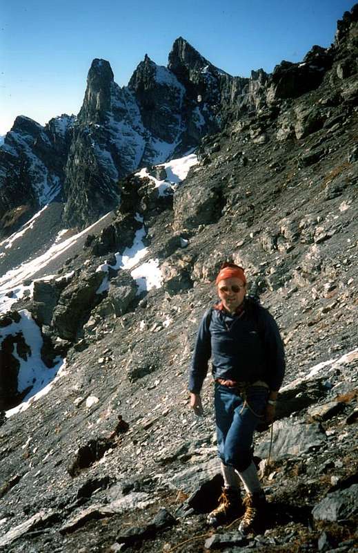
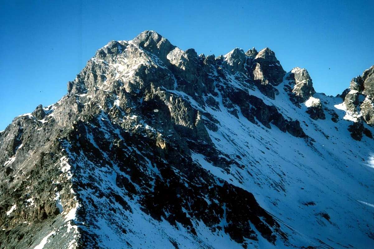
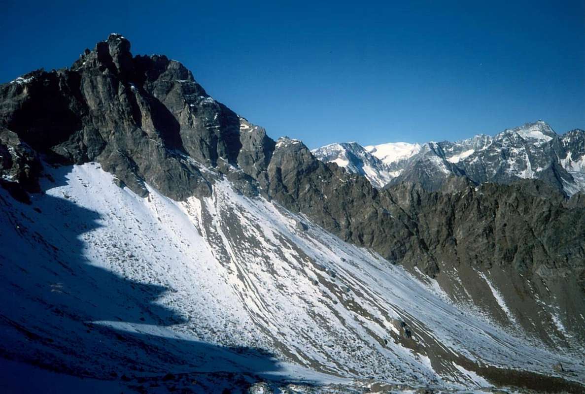
3) - get off at the opposite end to Plan Piscina and Champanement Alpage, rejoining it with the ascent itinerary, through the South Face that descends rather steeply for nearly three hundred meters, consisting of broken rock with terraces and debris often covered with grass (see photo; F+/PD-; some entertaining passage of II°, however, not mandatory; 1h'00). Even this way, which probably has not been the most repeated, is only a short cut to be no longer fit to the Hill of Chaleby; requires a little experience, otherwise the travel time instead of shorter stretches.
VIA NORMALE: dal Colle di Chaleby (2.683 m), facilmente raggiungibile sia da Sud ovvero dal Villaggio di Lignan attraverso Plan Piscina quanto da Nord con più lungo percorso arrivando dall'alpe presso il Santuario del Cuney, salire tramite la facile Cresta Sud-sudest; dapprima doppiare un muretto roccioso di colore sulfureo sulla sua sinistra (Sud; 2.755 metri circa) per mezzo di rocce più facili, ma ricoperte da molta erba. Subito dopo un successivo, con le medesime caratteristiche e costituito, inoltre, da buone fasce rocciose sulle quali bisogna saper trovare la via migliore, conduce alla parte terminale che progressivamente diventa sempre più facile e lineare fino al raggiungimento della Cima. Non lasciarsi sedurre da invitanti aggiramenti su di entrambi i lati, poiché il percorso sul filo di cresta risulta sicuramente più semplice, sicuro, migliore ed anche panoramico. (F+; 1h'15/1h'30 dal Colle di Chaleby; 2h'30/2h'45 dall'Alpeggio di Champanement; 3h'40/3h'50 da Lignan, tramite breve connessione ad Ovest-nordovest con il Col du Salvé).
VARIANTE: dal Colle Chaleby risulta inoltre possibile percorrere integralmente la cresta restando sempre sul filo di cresta, spartiacque della medesima, con breve arrampicata, ma sicuramente più impegnativa e divertente. Superato il primo risalto con rocce giallognole tramite passaggi che arrivano al massimo al II°+, si prosegue alacremente in direzione del successivo che presenta difficoltà appena superiori, con in mezzo un passaggio di III°-; superata anche questa fascia rocciosa si ritorna a congiungersi con la precedente via o "Via Normale", donde linearmente in Cima (calcolare 0h'20/0h'30 in più). Probabilmente questa via non é stata più percorsa, causa la cattiva qualità della roccia, erbosa.
DISCESE: 1) - tramite la via di salita oppure, volendo recarsi nel Vallone del Cuney:
2) - discendere per breve tempo lungo la Cresta Ovest-nordovest (collegamento sul divisorio con il Mont Pisonet) fino a raggiungere, per mezzo di blocchi piuttosto instabili, abbastanza facilmente la larga sella tra le due montagne, nei pressi d'un intaglio a quota 2.930/5 metri; dallo stesso calare lungo il Versante Nord formato da detriti e pietraie raggiungendo le pietraie seguite dai prati precedenti il Santuario (F; 0h '45). Inoltre é possibile:
3) - dirigersi dalla parte opposta verso Plan Piscina, l'Alpe di Champanement e quindi il Villaggio di Lignan, ricongiungendosi così all'itinerario di salita, tramite la Faccia Sud che scende piuttosto ripida per quasi trecento metri, formata da rocce rotte con terrazze di detriti (pericolo caduta pietre rimosse in transito) e spesso ricoperte da manto erboso (vedi foto; F+/PD-; qualche divertente passaggio di II°, peraltro non obbligatorio; 1h '00). Anche questa via, che probabilmente non é stata più ripetuta, costituisce esclusivamente una scorciatoia per non dover più rientrare al Colle di Chaleby; richiede un pò d'esperienza, altrimenti il tempo di percorrenza invece di accorciarsi si allunga con la ricerca della strada.
^^^^^^
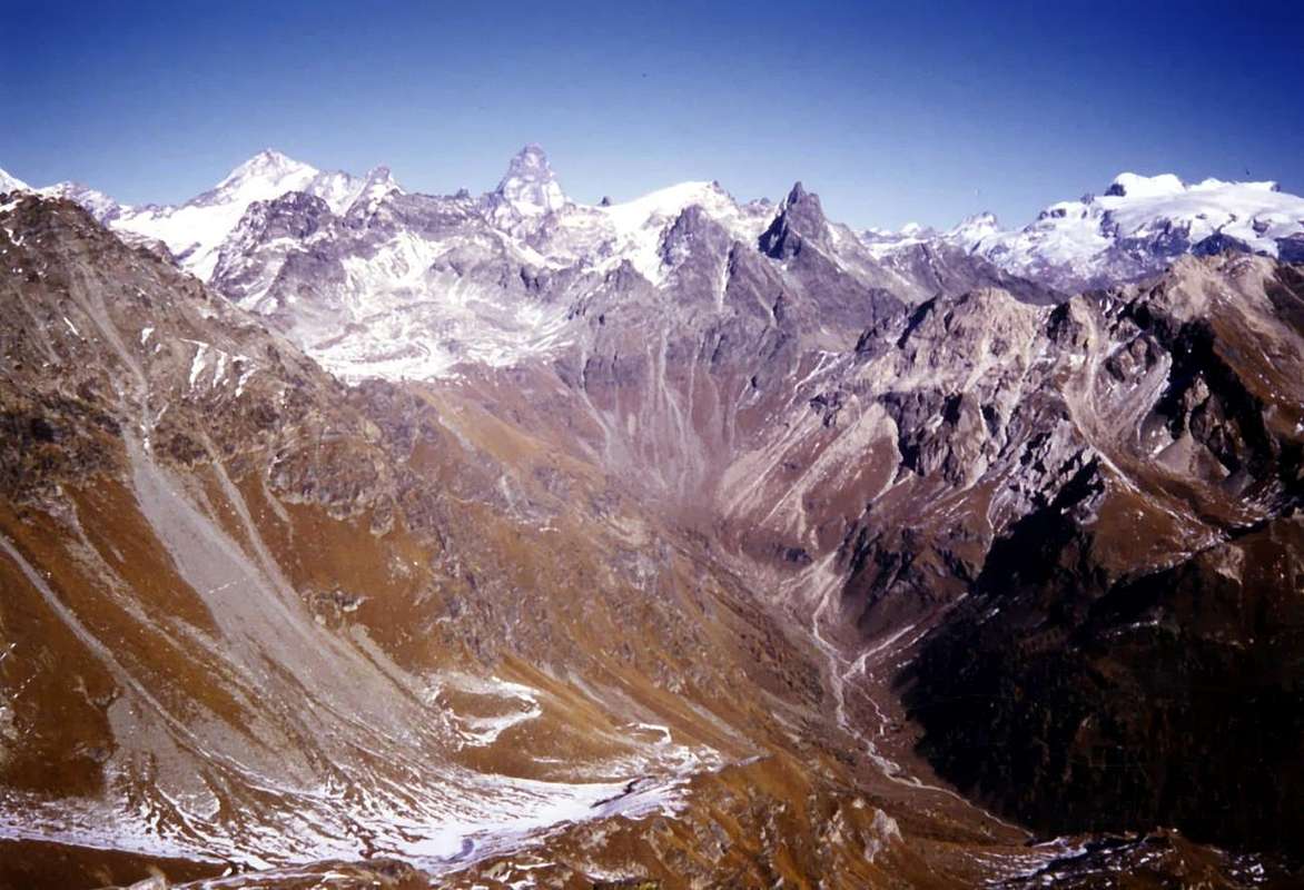
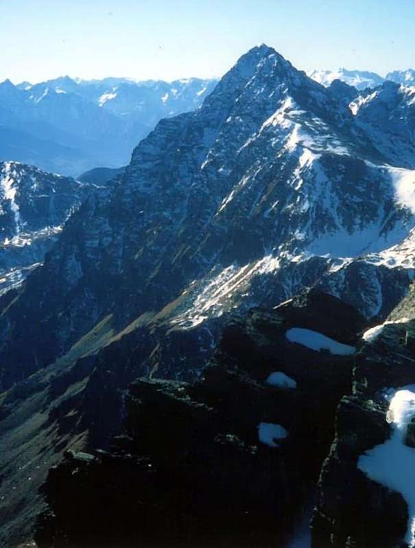
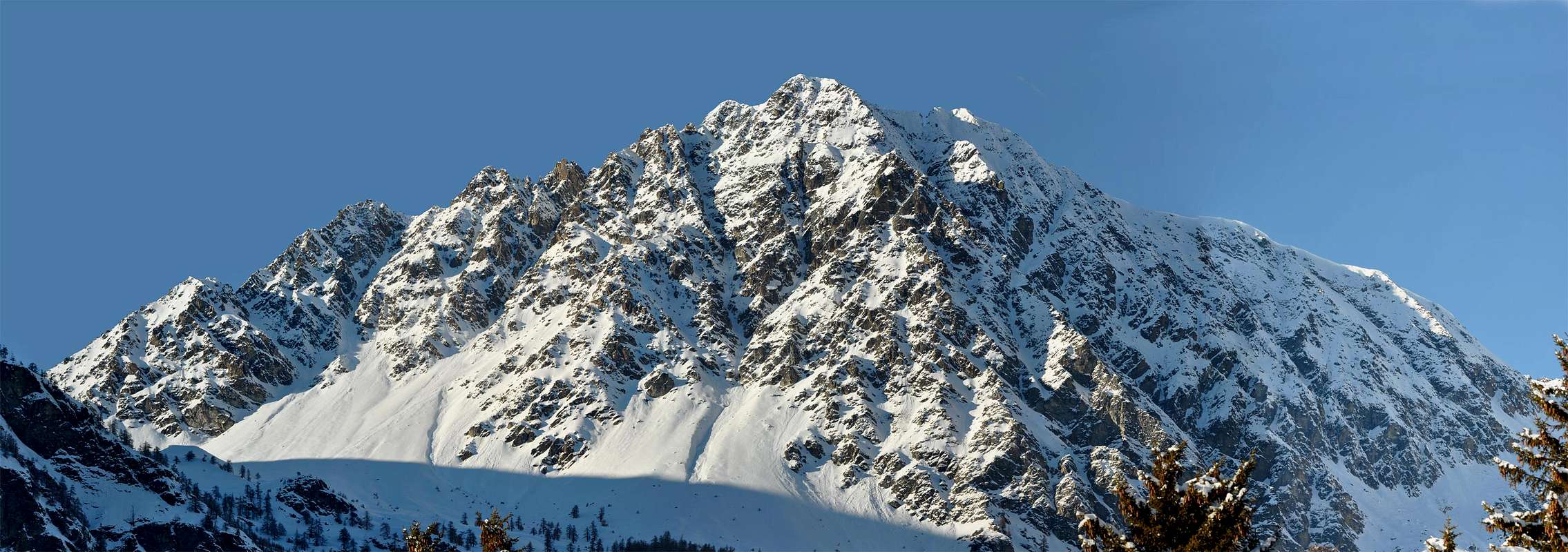
LOCATION: the above photo sequence we have the right placement of this second watershed (the first part from Becca of Roisan, above Roisan/Aosta Communes to get to Faroma at the end of Comba Dèche, while the third sector continues from Cuney Pass to Luseney Becca) from Monte Faroma is directed towards the Northeast act to separate the Valley of Saint Barthélemy from Valpelline. In order we have: Monte Faroma (3.073m), Vessona Hill (2.794m), three Jags of Vessona (about 3.000m, 3.020m, 3.060/75m approximately), Mont Pisonet (3.206m), Cima Nebbia (3.194m), Merlo Pass (about 3.020m), Becca del Merlo (3.231/4m), Ermite du Cuney (about 2.980m) and Cuney Pass (2.944m). Becca Fontaney, from which the photographs were taken, is located in the Southeast Pisonet on a watershed secondary between Walloons of Saint Barthélemy/Cuney.
LOCAZIONE: dalla soprastante sequenza fotografica abbiamo la giusta collocazione di questo secondo spartiacque (il primo parte dalla Becca di Roisan, sopra i Comuni di Roisan/Aosta per arrivare al Faroma in Comba Dèche, mentre il terzo settore prosegue dal Colle del Cuney fino alla Luseney) che dal Monte Faroma si indirizza verso Nordest atto a separare la Valle di Saint Barthélemy dalla Valpelline. In ordine abbiamo: Monte Faroma (3.073 m), Col Vessona (2.794 m), tre Denti di Vessona (3.000 m circa, 3.020 m, 3.060/75 m circa), Mont Pisonet (3.206 m), Cima Nebbia (3.194 m), Colle del Merlo (3.020 m circa), Becca del Merlo (3.231/4 m), Ermite du Cuney (2.980 m circa) e Colle del Cuney (2.944 m). La Becca Fontaney, dalla quale sono state prese le fotografie, si trova a Sudest del Pisonet su d'uno spartiacque secondario fra la Valle di Saint Barthélemy/Vallone del Cuney.
Difficulties
This Standard Route, starting from Chaleby Hill, can be considered F/F+.
South-southeast Crest (Integral on edge) F+/PD+ with short passages of II°/II°+ and one of III°-.
L'itinerario della Normale, partendo dal Colle Chaleby, è classificato F/F+.
Cresta Sud-sudest (Integrale sul filo) F+/PD+ con brevi passaggi di II°/II°+ ed uno di III°-.
This Standard Route, starting from Cuney Alp and Sanctuary, can be considered F/F+.
South Face (above Saint Barthélemy) from PD- to PD- with some passages II°+ and III°-, which was not required.
L'itinerario della Normale, partendo dall'Alpe del Cuney e Santuario tramite Versante Nord e Cresta Ovest-nordovest nella parte finale, è classificato F/F+.
Faccia Sud (sopra Saint Barthélemy) da PD- a PD- con alcuni passaggi di II°+ e III°-, peraltro non obbligatorii.
Equipment
Standard mountaineering equipment with rope.
Da alpinismo con corda.
Information
Meteo: you can find all the needed informations at the official site of the Valle d'Aosta Region:
"Guida della Valpelline" de l'Abbè Joseph-Marie Henry - Societè Editrice Valdotaine 1925 II Edition e Collana Reprint Musumeci (1986).
"Guida dei Monti d'Italia - Alpi Pennine" (Vol. 2) di Gino Buscaini - Club Alpino Italiano/Turing Club Italiano, Luglio 1970 (In Italian).
"80 itinerari di Escursionismo Alpinismo e Sci Alpinismo in Valle d'Aosta" di Osvaldo Cardellina Ed. Musumeci, Giugno 1977 prima ed. Luglio 1981, seconda ed. Luglio 1984, terza ed. Edizioni in francese prima ed. 25 Febbraio 1978, seconda ed. Marzo 1980.
"Dove andiamo in montagna? in Valle d'Aosta" di Domenico Caresio Edit. Tipografia Ferraro Ivrea, Marzo 1996.
"Diari Alpinistici" di Osvaldo Cardellina e Indice Generale accompagnato da Schedario Relazioni Ascensioni 1964-2019 (unpublished).
Parents refers to a larger category under which an object falls. For example, theAconcagua mountain page has the 'Aconcagua Group' and the 'Seven Summits' asparents and is a parent itself to many routes, photos, and Trip Reports.


 5379 Hits
 84.82% Score
 19 Votes