


-
 4442 Hits
-
 80.49% Score
-
 12 Votes
|
|
Mountain/Rock |
|---|---|
|
|
45.69050°N / 7.78590°E |
|
|
Hiking, Mountaineering, Trad Climbing |
|
|
Spring, Summer, Fall, Winter |
|
|
9895 ft / 3016 m |
|
|
Note
La montagna chiama i suoi figli, ed essi rispondono fedelmente al suo appello… Osvaldo Cardellina, Diario alpinistico, 1964-65 Page texts: @ OsvaldoCardellina "Osva", passed away on May 2, 2022. Page owners: Christian Cardellina e Osvaldo Cardellina. Any updates from September 12, 2022: Antonio Giani, page administrator, friend and climbing companion. Testi della pagina: @ OsvaldoCardellina "Osva", scomparso il 2 maggio 2022. Proprietari pagina: Christian Cardellina e Osvaldo Cardellina. Eventuali aggiornamenti dal 12 settembre 2022: Antonio Giani, amministratore della pagina, amico e compagno di salite. |
Twin & Sister Overview

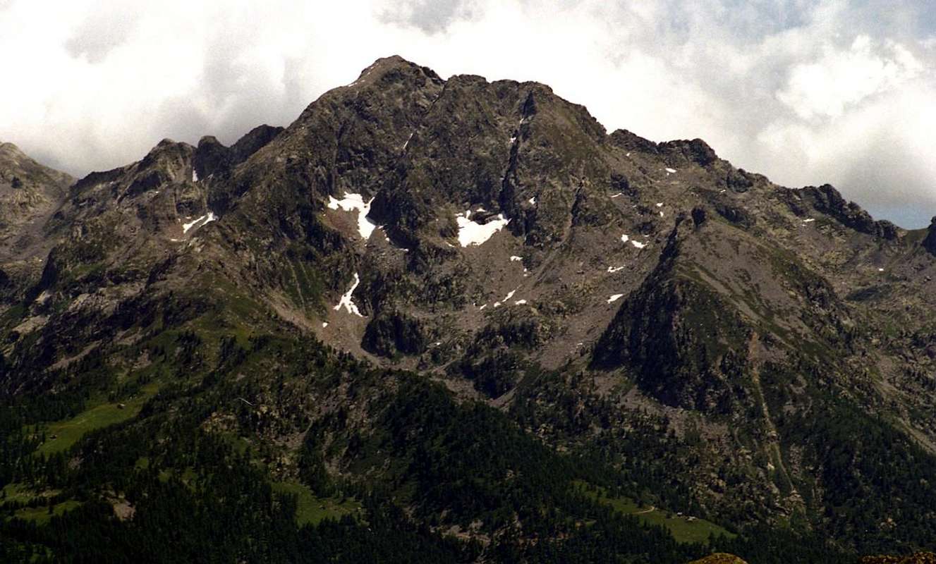
This Summit is the highest of the entire vallon that symbolically represents, then connecting the East with the "twin" Becca Vlou. A very elegant combination, but while Torché "belongs" to the Valley of Dondeuil, the other is located entirely in the Gressoney Valley overlooking the small Vallons of Scheity and Issime. Together, they form the so-called "Ladies of Challand", thanks to the exposure that are on this side of their two magnificent North Faces, always in sight going by the Media-High Ayas Valley; while the opposite slope are highlighted with less prominence. The Torché from the face Dondeuil does not offer any particular type of climbing, but, going through the Alpine Via, it does offer a pleasant hike through its Normal Via; the same we must highlight the ease stressing that a crossing of about fifty metres to the right and just over the hill, through a grassy ledge with caution because very exposed in the Southeast. It should also differentiate like hiking appearance changes completely departing from the Alps Dondeuil (having permission to take the dirt road by car), or, starting from Isollaz, with the full path of entire vallon; in this case, "resurfaces" an old way of going to the mountains with a nice "grind" that requires good hocks and a good dose of patience. In any case, it is beautiful, pleasant and scenic trip, through the easy Southern Crest or Standard Route from the Dondeuil Hill (2.338m). After crossing above easily follow the small path unnumbered, not reported and with sparce traces that will run along the edge or below the ridge, leaving to the left the so-called Becca's Dondeuil (2.746m), having in view and very close in foreground the "sister and twin" Becca of Vlou (3.032m).
![]()
![]()
![]()
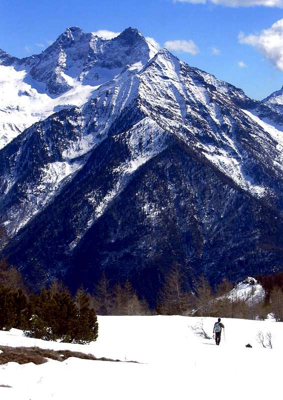
Risulta come la più elevata dell'intero vallone rappresentato simbolicamente, poi connettendosi ad Oriente con la "gemella" Becca di Vlou. Elegante connubio, ma mentre la Torché "si distende" verso il Vallone del Dondeuil, l'altra é completamente collocata nella Valle di Gressoney o del Lys dominando le piccole Valli di Scheity ed Issime. Insieme, formano le cosiddette "Dames de Challand", grazie all'esposizione che mostrano verso questo lato con le loro due magnifiche Pareti Nord, sempre ben in vista passando per la Valle d'Ayas medio-alta; mentre sul versante opposto s'evidenziano con minor risalto. La Torché dal versante Dondeuil non offre alcun particolare tipo di scalata, ma propone una piacevole passeggiata attraverso la sua Via Normale percorrente la Via Alpina verso Gressoney. Pur evidenziandone la facilità si deve sottolineare la presenza d'una delicata traversata d'una cinquantina di metri sulla destra appena oltre il colle, tramite una cengia erbosa da affrontarsi con cautela perché molto esposta a Sudest. Devesi inoltre differenziare come l'escursioni cambi aspetto completamente in partenza dalle Alpi Dondeuil (avendo il permesso di prendere la strada privata in auto), o, a partire dal Isollaz, con il percorso completo di tutto il Vallone del Dondeuil; in questo caso, "riemerge" un vecchio modo di andare in montagna con una bella "sfacchinata", richiedente più che buoni garretti ed una buona dose di pazienza. In ogni caso, è bello, piacevole e panoramico viaggio, tramite la facile Cresta Meridionale o Via Standard dal Col Dondeuil (2.338 m). Dopo la traversata di cui sopra, seguire facilmente il sentiero non numerato né segnalato e con tracce sparse risalente sullo spartiacque o ad Est appena sotto al medesimo lasciando sulla sinistra la cosiddetta Becca del Dondeuil (2.746 m), avendo ben in vista e frontalmente la vicinissima "sorella e gemella" Becca di Vlou (3.032 m).
First Ascents
- First on Summit: Probably the Surveyor Captain Cossato; (Summer 1831). Surely Abbot Aimé Gorret and Alessandro Martelli; (August 02th, 1872), through East Crest
- First ascents in winter: Eugenio Ferreri; (January 1915), in ascent with Southern Route. From North without known route: Flavio Binel and Guido Petrini (December 22th, 1974). By North Wall 1925 Via: Arturo and Oreste Squinobal (March (8/9th, 1977).
- East Crest: Aimé Gorret and Alessandro Martelli; (August 02th, 1872). Second: Agostino Ferrari with Mountain Guide Bisler (July 24th, 1897).
- North Wall and Northwest Crest: Franco Gatta and Gino Levi; (September 13th, 1925)
- North Wall: Amilcare Crétier and Dino Charrey (August 26th, 1928). In winter: Arturo and Oreste Squinobal (March (8/9th, 1977).
- North Wall (Variant 1935): Battista China and Giuseppe Solvay; (September 22th, 1935). Second: Ottavio Bastrenta and Ezio Capello; (August 16th, 1956).
- North Wall (Variant September 1974): Marco Giordano, lone; (September 14th, 1974).
- North Wall (Variant July 1978): Edoardo Ferrero, Piero Ferrero and Renato Gasparetto; (July 16th, 1978).
- North Wall (Variant September 1978): Savino Faletto, Beppe Franza and Silvio Mantoan; (September 10th, 1978).
- North Wall (Variant August 1982): Edoardo Ferrero, Pier Luigi Ferrero and Renato Gasparetto; (August 18th, 1982).
 |
 |
 |
 |
 |
Getting There
BY CAR:
- From TORINO, MILANO, etc: Motorway A5. Exit at IVREA or Quincinetto (PIEDMONT).
- From IVREA Town: in West (Southern side) to Pont Saint Martin, Verrès Municipalities in East from Aosta Town. From Courmayeur Resort: in East-southeast to Aosta, Nus, Chatillon, Saint Vincent, Verrès Municipalities.
- From Verrès to Val d'Ayas Valley From Verrès (549m), with Regional Road, to Challant Saint Victor-Isollaz (658m), Challant Saint Anselme-Quincod (1.030m), Tollegnaz Village (1.041m), Archésaz Hamlet (1.146m), Brusson (1.332m) Municipalities; wanting, continuing to Northwest to Antagnod-Ayas (1.709m) Commune, below Mounts Tantané and Zerbion also in North towards Champoluc (1.570m) and Saint Jacques(1.670m) Communes at the end of Evançon or Ayas Valley and under the Western side of Monte Rosa (Rollin Hump, Breithorns, Pollux and Castor).
- From FRANCE: through the Mont Blanc Tunnel to Entrèves/Courmayeur. By Little Saint Bernard Pass, closed since November until half May to La Thuile Valley - Pré Saint Didier - Aosta - Verrès Municipalities. It is not necessary to take Motorway A5: you can drive on SS.26, in the direction of AOSTA - IVREA - TURIN.
BY PLANE:
- Aeroporto "Corrado Gex" Saint Christophe (Aosta).
Approaches and Routes
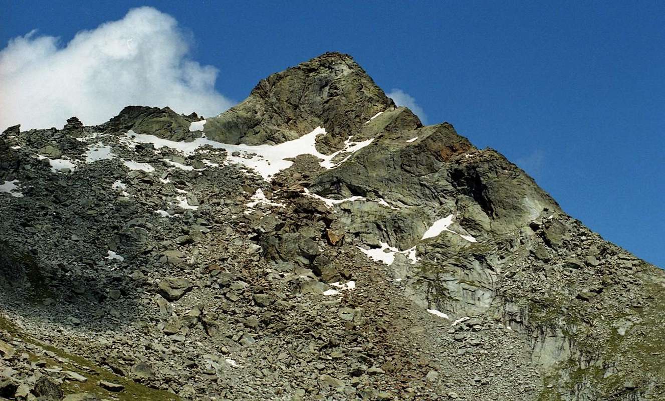
Approach A) - through Dondeuil Western Vallon and the South Ridge: this triangular Summit, shaped pyramid, is the highest of the entire vallon that symbolically represents, then connecting the East with the "twin" Becca Vlou (+ 3.032m). An elegant combination, but while Becca Torché "belongs" to the Dondeuil Vallon, the other is located entirely in the Gressoney or Lys Valley overlooking the small Valleys of Scheity and Issime. Together, they form the so-called "Ladies of Challand", thanks to the exposure that are on this side, above Challand St. Victor St. Anselme, of their two magnificent North Walls, symmetrically perfect and always in sight going by the Media High Ayas Valley; while the opposite slope are highlighted with less prominence, even because rather "hidden". The Torché from the face Dondeuil does not offer any particular type of climbing, but, going through the Alpine Via, it does offer a pleasant hike through its Normal Via; the same we must highlight the ease stressing that a crossing of about fifty meters to the right and just over the hill, through a grassy ledge with caution because very exposed in the Southeast. It should also differentiate like hiking appearance changes completely departing from the Alps Dondeuil (having permission to take the private road by car), or, starting from Isollaz, with the full path of entire vallon. In this case, "resurfaces" an old way of going to the mountains with a nice "grind" that requires good hocks and a good dose of patience. In any case, it is beautiful, pleasant and scenic trip.
1) - Through the easy Southern Crest or Standard Route from Dondeuil Hill (2.338m). After crossing above easily follow the small path unnumbered and not reported that will run along the edge or below the ridge to the right (East) (EE/F; 1h'30/2h'15 from hill; 3h'45/4h'15 from Dondeuil Alpage; 7h'15/7h'45 from Isollaz Village).
2) - Through Southwestern Slope from the more in bottom Chalex Alpages (1.780m) (EE/A/PD-; about 2h'30/3h'00 from upper rocky base; 7h'00/8h'00 Isollaz).
3) - Through Northwestern Ridge from le Tron Alp. This long ridge coming down from the Northwest to the Tip Meriaoù can also be reached from the Vallon of the same Dondeuil reaching from the Alp le Tron to the saddle of 2.700 meters after Becca Mortens and proceeding fairly smoothly on wire of the same (A; from PD- to PD+; about 3h'00/3h'15 from le Tron Alpahe; 7h'30/8h'30 from Isollaz Hamlet). Better to walk away from this with ascent through the Chasten Vallon from Tollegnaz Village, because the search for the via forward is simpler and requires less knowledge of the area being more visible. But even this route is as a way little known and rarely traveled.
![]()
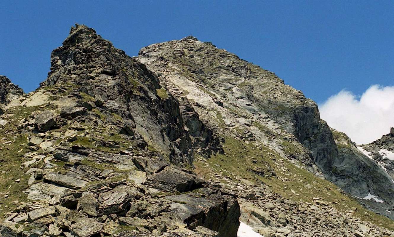
From the Summit towards Col Dondeuil & Pic des Allemands (2.747m)
Avvicinamento A) - dal per il Vallone Occidentale del Dondeuil e tramite la Cresta Sud: questa Cima risulta come la più elevata dell'intero vallone che simbolicamente rappresenta, poi connettendosi verso Oriente con la "gemella" Becca di Vlou (+ 3.032 m). Un elegante connubio, ma mentre la Torché "si distende" verso il Vallone del Dondeuil, l'altra é completamente collocata nella Valle di Gressoney o del Lys dominando le piccole Valli di Scheity e del Comune di Issime. Insieme, formano le cosiddette "Dames de Challand", grazie all'esposizione che mostrano verso questo lato sopra Challand St. Victor e St. Anselme con le loro due magnifiche Pareti Nord, simmetricamente perfette e sempre ben in vista passando per la Valle d'Ayas Medio-Alta; mentre sul versante opposto s'evidenziano con minor risalto, anche perché piuttosto "nascoste". La Torché dal versante Dondeuil non offre alcun particolare tipo di scalata, ma propone una piacevole passeggiata attraverso la sua Via Normale percorrente la Via Alpina verso Gressoney. Pur evidenziandone la facilità si deve sottolineare la presenza d'una delicata traversata d'una cinquantina di metri sulla destra appena oltre il colle, tramite una cengia erbosa da affrontarsi con cautela perché molto esposta a Sudest. Devesi inoltre differenziare come l'escursione cambi aspetto completamente in partenza dalle Alpi Dondeuil (avendo il permesso di prendere la strada privata in auto), o, a partire dal Isollaz, con il percorso completo di tutto il Vallone del Dondeuil. In questo caso, "riemerge" un vecchio modo di andare in montagna con una bella "sfacchinata", richiedente più che buoni garretti ed una buona dose di pazienza. In ogni caso, è un bel, piacevole e panoramico viaggio.
1) - Tramite la facile Cresta Meridionale o Via Standard dal Col Dondeuil (2.338 m). Dopo la traversata di cui sopra, seguire facilmente il sentiero non numerato né segnalato risalente sullo spartiacque o ad Est appena sotto al medesimo (EE/F; 1h'30/02h'15 dal colle; 3h'45/04h'15 dall'Alpe Dondeuil; 7h'15/7h'45 dal Villaggio di Isollaz).
2) - A mezzo del Versante Sudovest partendo dagli Alpeggi di Chalex (1.780 m) (EE/A/PD-; 2h'30/3h'00 circa dalla base superiore; dalle 7h'00 alle 8h'00 da Isollaz).
3) - Con la Cresta Nordovest dall'Alpe le Tron. Questa lunga cresta discende a Nordovest in direzione della Punta di Meriaoù ma é inoltre raggiungibile dallo stesso Vallone del Dondeuil raggiungendo dall'Alpe le Tron la sella a quota 2.700 metri dopo la Becca Mortens e procedendo abbastanza agevolmente sul filo dello stesso (A; da PD- a PD+; 3h'00/3h'15 circa da le Tron; 7h'30/8h'30 da Isollaz). Risulta meglio non procedere con questo vallone utilizzando quello di Tollegnaz Chasten, perché la ricerca della via di salita è più semplice e richiede meno conoscenza del territorio ed é facilmente più individuabile. Anche questa risulta come via poco conosciuta e assai raramente percorsa.
Approach B) - through Valbona and Dondeuil Eastern Vallons:
4) - reached Issime (953/80 m; the Church of San Giacomo) with a short detour from the Regional Road for the Gressoney Valley, take the path n° 1/Via Alpina that rises to the West-northwest in the direction of the Valbona Vallon. The same, after a first series of hairpin bends reaches Santa Margherita, where comes the farm road. A long diagonal passing through the Alps Zeuin, Lamatta (1.787m), vain, Vieukie, Methia, Mongiovetta salt reaching the same in succession to reach after the Alpe di Mounes Dèsott or Lower (+; 2.008 m; Chapel of "Madonna della Neve"). Continuing to the West with path towards that Damon and Colle Dondeuil (2.338m; EE/F until the crest, then EEA/F+; 6h'00/6h'30 from Issime Municipality). Logically from the Hill goes up to the North with unnumbered small path and traces always through the Southern Crest, disscarting West the adjacent Punta or Becca del Dondeuil (2.746m), flanked by a large and isolated rocky Gendarme.
5) - From the Valley of Valbona and the Eastern Edge: always coming from Issime and with the same path n° 1/Via Alpina, or with the two adjacent n° 1C and unnumbered more towards the South, you reach the Alp Munes Superior. From this a track, first in the North to Alp Vlou Bottom (2.215m) and then bearing to the Upper West (2.363m; E/F; 1h'00), located on the slopes of a small narrow vallon between Becca Vlou (West) and Becca Torché. From this, content from the Southern Ridges Torché and Vlou, no trail and nor trace, but with somewhat laborious path through steep moraine and overlapping blocks, back to the above and close Saddle about 2.895/900 meters with the Normal Route for Becca Vlou (at the beginning of the season the presence of snow fields at the top; EE/F+; 1h'20 by the upper alp). Climb the Ridge Eastern, short, sharp and exposed on both sides and formed from plates of good rock (II°/II°+) arriving in the final part nearby a chimney of about ten metres (III°-/III°+), which is avoided with short bypass to the left (South) reaching rocks easier but covered with debris and grass. Brief but always delicate ascent (A/ from PD- to PD+; 1h'00 by the saddle). On this ridge strangely we were made the first two ascents known of 1872 and of 1879, although at the first was certainly covered the easier South Ridge (1831).
Avvicinamento B) - tramite i Valloni di Valbona ed Orientale del Dondeuil:
4) - raggiunto il Comune di Issime (953/80 m; Chiesa di San Giacomo) con una breve deviazione dalla Strada Regionale per la Valle di Gressoney, prendere il sentiero n° 1/Via Alpina risalente ad Ovest-nordovest in direzione del Vallone di Valbona. Lo stesso, dopo una prima serie di stretti tornanti raggiunge Santa Margherita, dove arriva anche la strada poderale. Un lungo diagonale che passa per le Alpi Zeuin, Lamatta (1.787 m), Invan, Vieukie, Methia, Mongiovetta sale raggiungendo le medesime in successione per raggiungere in seguito l'Alpe di Mounes Dèsott od Inferiore (+; 2.008 m; Cappella della "Madonna della Neve"). Procedendo ad Occidente col sentiero che continua verso quella Damon ed il Colle Dondeuil (2.338 m; EE/F sino alla cresta, indi EEA/F+; 6h'00/6h'30 dal Comune di Issime). Logicamente, come dal precedente Avvicinamento ed Itinerario A 1) dal Colle proseguire con sentierino non segnalato e tracce a Nord sempre per mezzo della Cresta Meridionale, scartando ad Ovest la Punta o conosciuta in loco quale Becca del Dondeuil (2.746 m), fiancheggiata da un grande ed isolato Gendarme roccioso.
5) - Dal Vallone di Valbona e la Cresta Est: sempre arrivando da Issime e con il medesimo sentiero n° 1/Via Alpina, oppure con gli adiacenti n° 1C e non numerato più verso Mezzogiorno, si raggiunge l'Alpe di Munes Superiore. Da questa una traccia dapprima a Settentrione raggiunge l'Alpe di Vlou Inferiore (2.215 m) e poi, piegando ad Occidente quella Superiore (2.363 m; E/F; 1h'00), collocata alle pendici di uno stretto valloncello tra Becca di Vlou (Ovest) e Becca Torché. Da questo, contenuto dalla Cresta Sud della Torché e Meridionale della Vlou, risalire senza sentiero e neppure tracce ma con percorso alquanto faticoso tramite ripida morena e blocchi sovrapposti verso la soprastante e ristretta Sella 2.895/900 metri circa con la Via Normale per la Becca di Vlou (ad inizio di stagione presenza di nevai nella parte più elevata; EE/F+; 1h'20 dall'alpe superiore). Salire la Cresta Orientale, breve, affilata ed esposta su entrambi i lati e formata da placche di buona roccia (II°/II°+) raggiungendo nel finale un camino di dieci metri circa (III°-/III°+), evitabile con corto aggiramento sulla sinistra (Sud) raggiungendo rocce più facili ma ricoperte da detriti ed erba. Salita breve ma sempre delicata (A/ da PD- a PD+; 1h'00). Su questa stranamente si registrano le prime due ascensioni note del 1872 e 1879, anche se sicuramente era già stata percorsa la più facile Cresta Sud (1831).
![]()
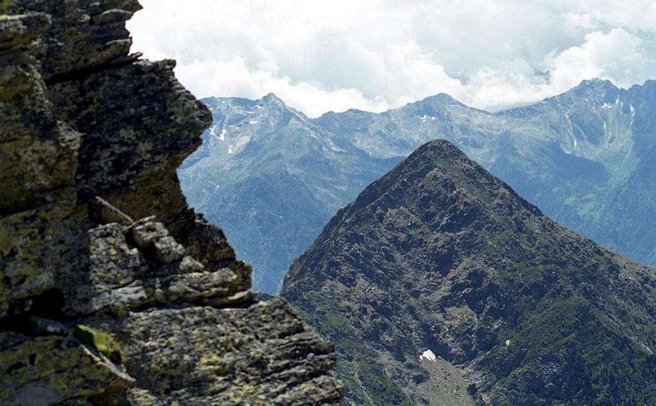
From the Top to Northeast and Mont Nery or Becca Frudiera (3.075m)
Difficulties & Equipment
This route can be considered E/F or EEA/F+ (Experts Hikers and Mountaineers) in winter (even by Ski).L'itinerario è da classificare in E/F oppure EEA/F+ (Escursionisti Esperti od Alpinisti) in inverno (anche in Scialpinismo).
Hiking gear, in winter as for Ski-Mountaineering.
 |
 |
 |
 |
 |
Da Escursionismo, in inverno da Scialpinismo.
Mountain Conditions
- You can get meteo information at the official site of the Regione Valle d'Aosta:
- Valle d'Aosta Meteo
- Meteo: You can find more weather information on the website 3B Meteo:
- Meteo Issime
Books and Maps
- "Guida delle Alpi Occidentali" di Giovanni Bobba e Luigi Vaccarone C.A.I. Sezione di Torino Volume II (parte II), 25 Maggio 1896.
- "Guida dei Monti d'Italia" Alpi Pennine (Vol. 2) di Gino Buscaini - Club Alpino Italiano/Turing Club Italiano, Luglio 1970 (In Italian).
- ""Alpinismo e Escursionismo in Val d'Ayas" di Giorgio Merlo, Ed. CDA Torino Maggio 1984.
- "Diari Alpinistici" di Osvaldo Cardellina e Indice Generale accompagnato da Schedario Relazioni Ascensioni 1964-2019 (unpublished).
 |
 |
 |
 |
- Meridiani Montagne "Monte Rosa" Carta 1.50.000 con carta di dettaglio 1.20.000.
- L'Escursionista "Val d'Ayas Val di Gressoney Monte Rosa" Carta dei sentieri (n° 8) 1:25.000.
- Comunità Montana Evançon "Carta dei sentieri" (n° 2), 1:30.000.
- Kompass "Breuil/Cervinia-Zermatt" Carta turistica 1:50.000.
- I.G.C. Istituto Geografico Centrale Torino "Cervino e Monte Rosa" 1:50.000.
Important Information
- REGIONE AUTONOMA VALLE D'AOSTA the official site.
- FONDAZIONE MONTAGNA SICURA Villa Cameron, località Villard de la Palud n° 1 Courmayeur (AO) Tel: 39 0165 897602 - Fax: 39 0165 897647.
- A.I.NE.VA. (Associazione Interregionale Neve e Valanghe).
Useful numbers
- Protezione Civile Valdostana località Aeroporto n° 7/A Saint Christophe (Ao) Tel. 0165-238222.
- Bollettino Meteo (weather info) Tel. 0165-44113.
- Unità Operativa di Soccorso Sanitario Tel. 118.