
-
 10328 Hits
-
 87.76% Score
-
 25 Votes
|
|
Mountain/Rock |
|---|---|
|
|
45.79990°N / 7.40403°E |
|
|
Aosta Valley |
|
|
9682 ft / 2951 m |
|
|
Overview
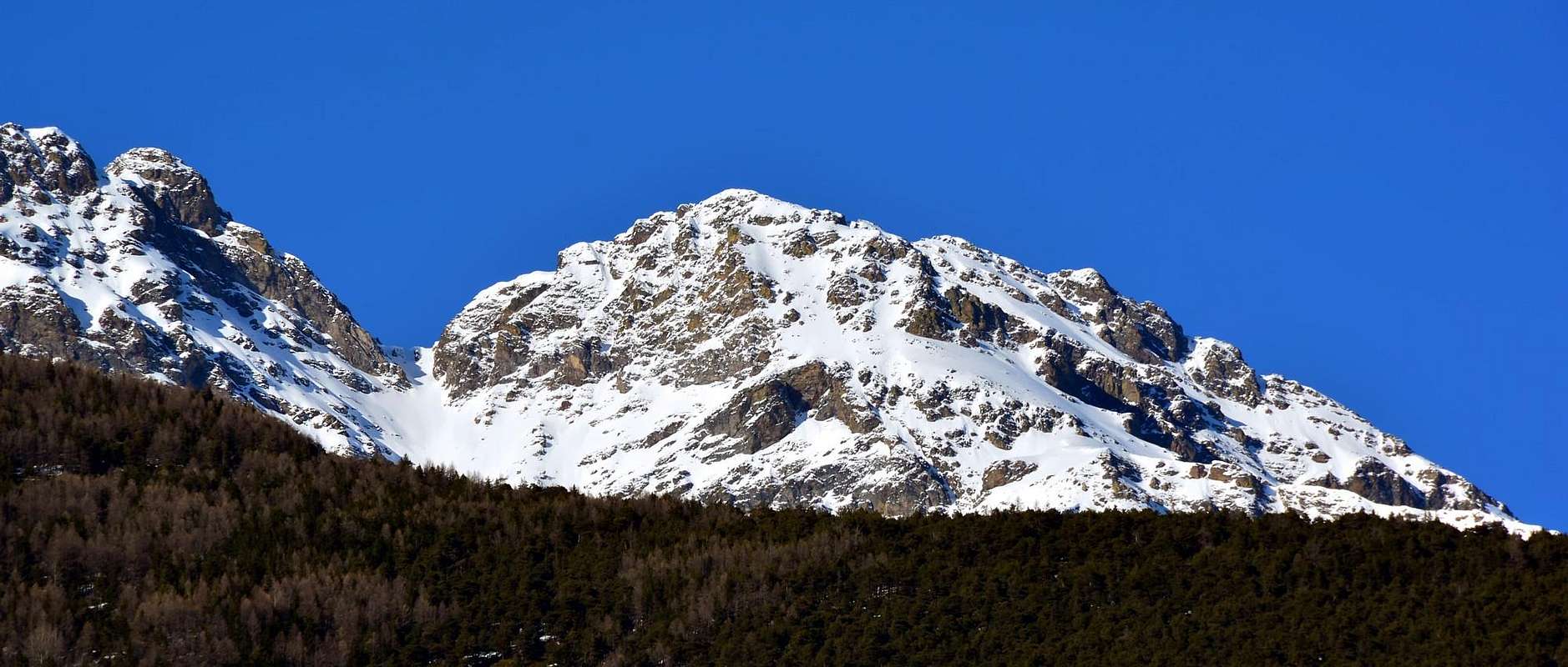
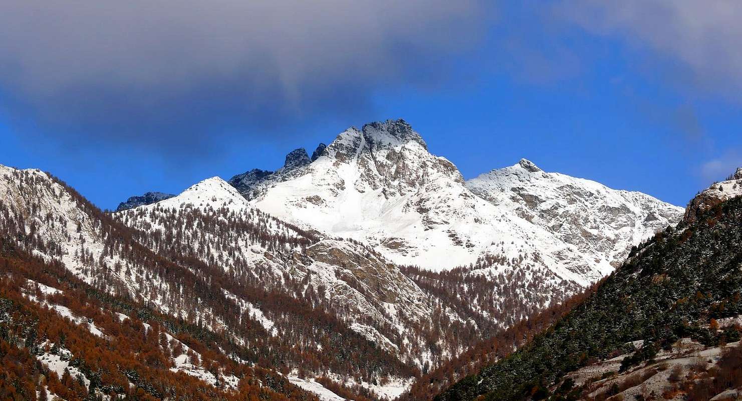
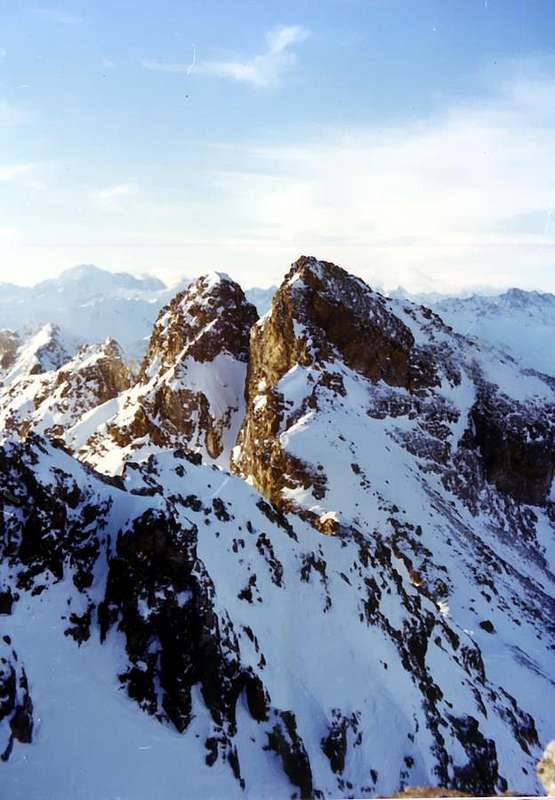
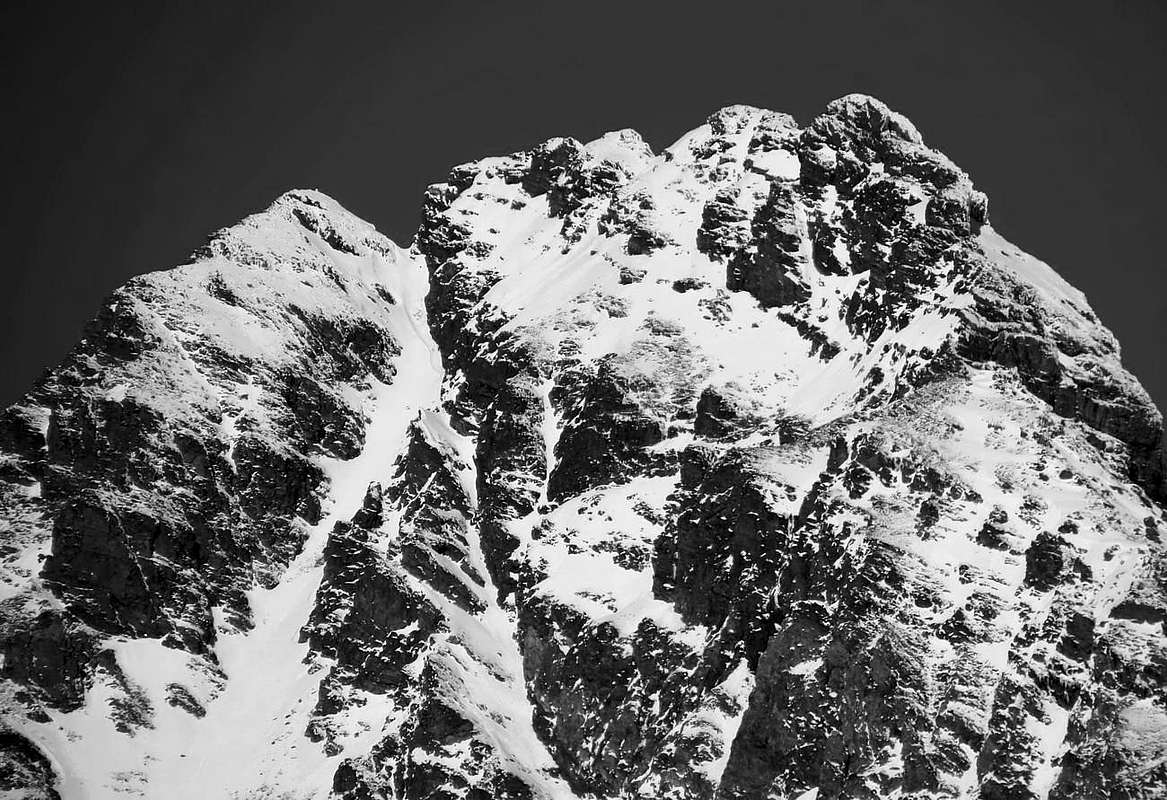
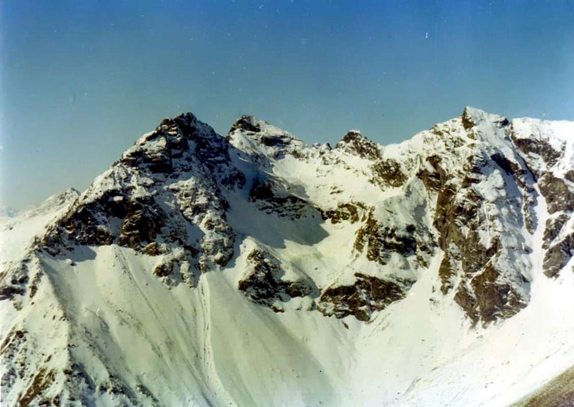
This top of enough notable mass and rounded off form is situated to the Oriental extremity of the long coastline that from the Becca of Roisan it is addressed to East forming the Becca of Viou, the Mont Mary, the Tête of Arpisson, the Point of Senevé and the two summits of the Tsaat a l'Etsena (2.974/5 meters around the East Point, the most elevated of the whole coastline; you always see in SP: Becca of Roisan, Becca of Viou, Tête of Arpisson and Tsaat to the Etsena, where in this last one detailed and minute description of the whole small fit mountainous chain it results to separate the Central Valley of the River Dora Baltea from the long North Valpelline), further to a series of other little points, small towers, pinnacles, necks, collars, carvings etc. Like this, arriving from the Fana's Pass he takes beginning another secondary branch that, after having formed the five Beaks of Fana (2.951m; four anymore an Antesummit Western 2.945 meters around), it goes down toward South-southeast in direction of the Central Valley of the Dora Baltea Stream up to the three Villages of Trois Villes (1.391m) above the Communes of Quart and Nus. This long buttress but of modest appearances it forms, road doing, the Tall Pass (2.540 meters around), the Northern Point of the Cornet also Quota 2.484 meters around, the homonym Hill (2.272m), the Southern Point or Quota 2.306 meters, the Collar 2.226 meters to finish with the Croix de Fana (2.222m), splendid belvedere (= viewpoint) set to form of advanced balcony on the development of big part of the Central Valley of the Dora Baltea. But the true top of the Beaks of Fana results prepared on the axle Nordovest/Sudest, formed by a brief Crest Northwest that, arriving from the Hill of Fana (2.880 meters around), it reaches at first the West Antesummit and, after a narrow Carving 2.930/2 metres around and mostly turning to East, it gets up to the Central Beak of Fana the tallest of a series of small summits (2.950/1 meters around). Summit already slope in winter in 1974 but a great deal rarely frequented, above all for the length of the approaches but also because unknown for many mountain climber to respect of his route of slope. Formed by fragile rocks and routs of the same type of Tsaat al'Etsena (kinzigites, minute gneiss and micaschist) introduces, describing it in sense hourly anti, advisable four only "via" of slope:
- 1) - a small gully of few more than center meters on the slope North that brings to the Carving 2.930/2 metres about, between the Peak of the Maximum Top and the West Antetop; it asks for prudence in snow's presence not transformed or floury but very amusing with hard and good snow.
- 2) - the brief crest Northwest that from the Fana Pass it always reaches at first the same antesummit slightly holding himself under the North Crest (it has integrally been crossed already in 1978 with more amusing slope); climbed brief and easy on broken rout. In the case of slope on the thread of crest to be foreseen the overcoming of a small vertical wall of a two weeks of meters (passages of II°+ and III° -).
- 3) - the big Crest South-southeast that originates from the Hill 2.540 meters around or Tall Pass to reach at first the West Antetop; almost certainly it is the street of the first slope in 1912 from the Abbé J. M. Henry. Sure and panoramic and amusing run, if effected in presence of transformed snow.
- 4) - the small Couloir Southeast that goes down toward the Comba, or Little Basin, Dèche in direction of the Clavel-Rossin-La Pesse Pastures; crossed amusing, if faced with hard and transformed snow, and already effected in descent in 1975.
Questa cima di massa abbastanza notevole e di forma arrotondata è situata all'estremità Orientale della lunga costiera che dalla Becca di Roisan s'indirizza ad Est formando la Becca di Viou, il Mont Mary, la Tête d'Arpisson, la Punta di Senevé e le due sommità della Tsaat a l'Etsena (2.974/5 m~ la Punta Est, la più elevata dell'intera costiera; vedi sempre in SP: Becca di Roisan, Becca di Viou, Tête d'Arpisson e Tsaat a l'Etsena, dove in questa ultima risulta una dettagliata e minuziosa descrizione dell'intera piccola catena montuosa atta a separare la Valle Centrale del Fiume Dora Baltea dalla lunga Valpelline a Settentrione), oltre ad una serie di altre puntine, torrette, pinnacoli, colli, colletti, intagli ecc. Così, arrivando dalla Punta Orientale di Tsaat a l'Etsena, dal Colle di Fana prende inizio un'altra ramificazione secondaria che, dopo aver formato i cinque Becchi di Fana (2.951 m; quattro più un'Antecima Ovest 2.945 m~), scende verso Sud-sudest in direzione della Valle Centrale della Dora insino ai tre Villaggi di Trois Villes (1.391 m) sopra i Comuni di Quart e di Nus. Questo contrafforte lungo ma di modeste apparenze forma, strada facendo, il Passo Alto (2.540 m~), la Punta Settentrionale del Cornet nella Quota 2.484 m~, l'omonimo Colle (2.272 m), la Punta Sud oppure Quota 2.306 m, il Colletto 2.226 m per terminare con la Croix de Fana (2.222 m), splendido belvedere posto a forma di balcone avanzato sullo sviluppo di gran parte della Valle Centrale della Dora Baltea. Ma la vera cima dei Becchi di Fana risulta disposta sull'asse Nordovest/Sudest, formata da una breve Cresta Nordovest che, arrivando dal Colle di Fana (2.880 m~), raggiunge dapprima l'Antecima Ovest e, dopo uno stretto Intaglio 2.930/2 m~ e volgendo maggiormente ad Est, si innalza al Becco di Fana Centrale il più alto di una serie di piccole sommità (2.950/1 m~). Cima già salita anche in inverno nel 1974 ma assai raramente frequentata, soprattutto per la lunghezza degli approcci eppure perché sconosciuta per molti alpinisti a riguardo della sua via di salita. Formata da rocce fragili e rotte dello stesso tipo di Tsaat a l'Etsena (kinzigiti, gneiss minuti e micascisti) presenta, descrivendole in senso anti orario, quattro sole vie di salita consigliabili:
- 1) - un canalino di poco più di cento metri sul Versante Nord che porta all'Intaglio 2.930/2 m~, tra la Vetta della Cima Massima e l'Antecima Ovest; richiede prudenza in presenza di neve non trasformata o farinosa e divertente invece con neve buona e dura.
- 2) - la breve cresta Nordovest che dal Colle di Fana arriva dapprima sempre alla stessa antecima tenendosi leggermente sotto la cresta a Nord (è già stata percorsa integralmente nel 1978 con salita più divertente); salita breve e facile su rotta rotta. Nel caso di salita sul filo di cresta da prevedere il superamento di un piccolo muro verticale di una quindicina di metri (passaggi di II°+ e III°-).
- 3) - il Crestone Sud-sudest che proviene dal Colle 2.540 m~ o Passo Alto per raggiungere dapprima l'Antecima Ovest; quasi certamente è la via della prima salita nel 1912 da parte dell'Abbé J. M. Henry. Percorso sicuro e panoramico e divertente, se effettuato in presenza di neve trasformata.
- 4) - il Canalino Sudest discendente verso la Comba Dèche in direzione delle Alpi Clavel-Rossin-La Pesse; percorso divertente, se affrontato con neve dura, e già effettuato in discesa nel 1975.
 |
First Ascents
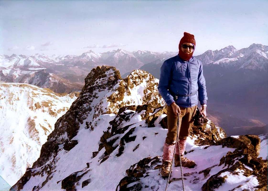
- First on the Summit: Abbé Joseph Maria Henry, lone, (Aug 12th, 1912).
- In Winter: Osvaldo Cardellina, Marco Cossard and Giuseppe Lamazzi, (Dec 29th, 1974).
- N Slope (trough the Northern Gully): Unknown.
- S Great Crest to West Antesummit final part of W-NW Arête (Standard Route to Summit): Abbé Joseph Maria Henry, lone, (Aug 12th, 1912).
- Great Traverse (from Saint Barthélemy Hill-Quota 2.826m-Quota 2.914m-Becca Conge-First Ascent Absolute of Punta J.M. Henry-Tsaat a l'Etsena Eastern Top and integral traverse to Fana Pass and Western Ante Top and all four Becchi di Fana in ascent and descent to North-northeast through the Collar 2.925m around): Osvaldo Cardellina and Giuseppe Lamazzi, (Aug 20th, 1978).
- W-NW Arête (integral fron Fana Hill): Osvaldo Cardellina and Giuseppe Lamazzi, (Aug 20th, 1978), in ascent.
- SE Couloir (from West Antetop to Passo Alto): Osvaldo Cardellina, Marco Cossard, Camillo Roberto Ferronato, Giuseppe Lamazzi and Nino Trapani, (Jun 29th, 1975), in descent.
- SW Face of Western Antesummit (Direct Line) and crossing of all beaks: Osvaldo Cardellina, lone, (Jun 25th,2005), in ascent.
- E-SE Crest (to Clavel Alp): Osvaldo Cardellina, lone, (Jun 25th, 2005), in descent.
- Integral crossing from Becca di Roisan-Tsaat a l'Etsena Western and Eastern Summits to Croix de Fana (Becca di Roisan-Quota 2.494m-Becca di Viou-Mont Mary-Quota 2.750/1 about o Punta di Chamerod-Quota 2.748/8 o Punta de Les Prèles-Tête d'Arpisson-Quota 2.888m-Quota 2.865/70m about also Senevé Little Bell Tower-Punta di Senevé-Quota 2.945/50m about-Tsaat a l'Etsena West and East Tops-Becchi di Fana-Punta del Cornet-Croix de Fana): Osvaldo Cardellina, lone, (Oct 11th, 1992).
 |
- First on the Ante Summit: Abbé Joseph Maria Henry, lone, (Aug 12th, 1912), in ascent and in descent through the S-SE Great Crest.
- In Winter: Osvaldo Cardellina, Marco Cossard and Giuseppe Lamazzi, (Dec 29th, 1974), in ascent and in descent through the Fana's Pass and Northern Gully.
- First or Western Oriental Beak (2.944/5 metres about): Osvaldo Cardellina, lone, (Dec 29th,1974), in traverse from the Top and return from Central Oriental Beak.
- * First Replay: idem (Jun 29th, 1975).
- ** Second Replay: idem (Oct 11th, 1992), in great crossing from Becca of Roisan to Croix de Fana.
- *** Third Replay: idem (Jun 25th, 2005), in crossing from Passo Alto through the S-SE Great Crest to Western Antesummit and traverse of all beaks.
- In Winter: idem (Dec 29th, 1974).
- Second or Central Oriental Beak (2.940 metres about): Osvaldo Cardellina, lone, (Dec 29th,1974), in traverse from the Western Oriental Beak and return from Eastern Oriental Beak.
- * First Replay: idem (Jun 29th, 1975).
- ** Second Replay: idem (Oct 11th, 1992), in great traverse.
- *** Third Replay: idem (Jun 25th, 2005), in crossing from Passo Alto through the S-SE Great Crest to Western Antesummit and traverse of all beaks.
- In Winter: idem (Dec 29th, 1974).
- Third or Eastern Oriental Beak (2.938 metres about): Osvaldo Cardellina, lone, (Dec 29th,1974), in traverse from the Central Oriental Beak and return in crossing to Western Ante Summit.
- * First Replay: idem (Jun 29th, 1975).
- ** Second Replay: idem (Oct 11th, 1992), in great traverse.
- *** Third Replay: idem (Jun 25th, 2005), in crossing from Passo Alto through the S-SE Great Crest to Western Antesummit and traverse of all beaks and descent by E-SE Ridge to Clavel Alpage.
- In Winter: idem (Dec 29th, 1974).
![]()
Dissertations and observations at the foot
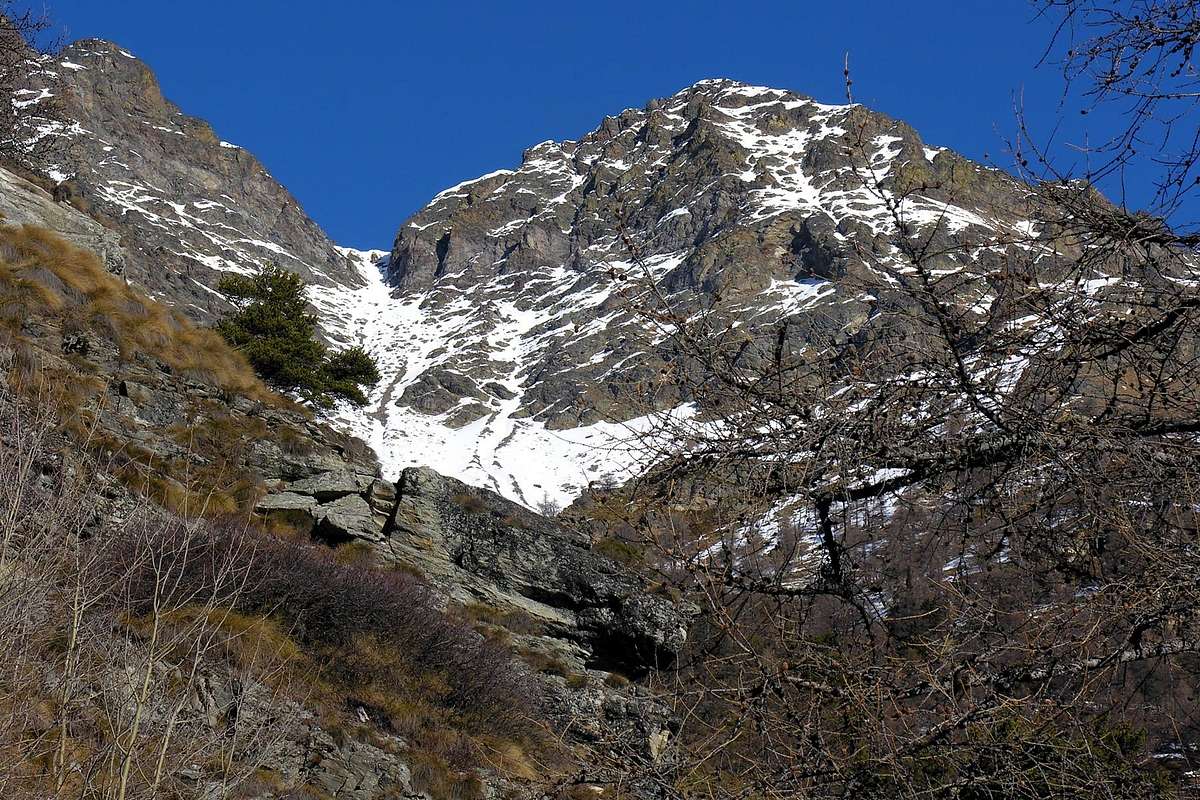
Observations and little dissertations here belowFrom now note how this mountain, though poorly attended, both have traveled far and wide along its slopes and on ridges; nevertheless remains yet to explore the wide Northern and Southern edges in the part that goes from the Central Beak to the Three Oriental Beaks. On the North Slope a steep wall of broken rock, a little less than 200 meters high, falls on the second narrow section of the Via D falling on the steep moraine below. Further to the East, the same will appeal more to the North-northeast and then to the Northeast a small rocky rib descending from the Ridge East-southeast, approximately doubling its height and ending below the first "bottleneck". All along this area of the wall leaves, from an analysis performed during the crossing of the same or summary observation from below, portends no good for climbing into account the poor quality of the rocks; instead could become interesting in winter with the search for some "goulotte" (= gully) glacial, so fashionable today. In any case the approach is dangerous, especially in the slopes of the steep slope below the face thereof, and requires good snow and well transformed, factor that rarely coincides with the requirements of the first observation. With regard to the South Slope it should be pointed like a high wall and repulsive, more than four hundred meters, characterizes it with steep rocks, which called for an exploration, after a big jump rocky debris following a ledge that goes diagonally under the beaks, from the right (East) to the left, to be extinguished at the Central Beak, the highest, beneath a steep rocky jump. Below this a tiny gully (not to be confused with the nearby Couloir South-southeast or Route F, which meets under a rock band and steep diagonal in the notch 2.930/2 meters around; see picture in black and white in the "Routes"), as long as the large sloping ledge and also addressed the Summit, meeting very tight. It might be interesting to explore this wide and steep, possibly combined with hard snow conditions and transformed; become a good workout on mixed terrain at the end of the season (May/June). With a short dissertation to remember that it is not observed in these mountains that you write or discover the history of mountaineering, but still offer the same recondite places, away from the masses, with a wild and untouched nature that still allows the pleasure exploration and following discovery. This speech has value not only for the small mountain range that unfolds from Becca of Roisan to the Beaks, but for the entire coastal separates the Central Valley of the River Dora Baltea/Valley of Saint Barthélemy and Valpelline to the Petites Murailles, Mount Faroma and Becca Luseney included and comprehensive from the same branching out. Incidentally these old mountains have undergone a remarkable transformation process, for which what the rock is crumbling and becomes more and more with the passage of time covered by turf increasingly widespread, which lies on the same and is wedged between the cracks. Here nails do not exist and if you have to make sure someone to drive well, because not only the same could leave out but you might expect to see disconnect the block "raped" and we are in the realm of primordial nature, as well as created. Otherwise please contact the granite blocks and the famous routes; You will follow the 7777 ascension to the East of the Grand Capucin or, putting neatly in a row, wait for it to liberate the fixed ropes of the Dente del Gigante! Here, however, require the eye and the foot of the mountain or high mountain hunter to choose the best route and support, network security is no longer an objective factor related to technical artifices and stratagems, but rather a subjective and inner conviction of what is faces and is realized from moment to moment. It's not even a go looking for trouble, but the belief of what you want to do. To that end we have seen rock climbers of the sixth degree or free climbings and go paddling in difficulty on the difficulty of II ° or slightly more, on steps of soil with stones glued with spit. Clearly without any insurance spit! What followed for over forty years is a fashion "In". But it is a going to the mountains that just do not care ... Incidentally "chaqun a sa marotte" ovvero "ad ogni matto la sua fisima" and for You and "everyone cultivates their "mattana" (= fixed and crazy idea)".
 |
 |
 |
 |
Osservazioni e piccole dissertazioni in calce
Da annotare com'ormai questa montagna, anche se scarsamente frequentata, sia stata percorsa in lungo ed in largo lungo i suoi versanti nonché relative creste; ciononostante rimangono ancora da esplorare le larghe facce Settentrionali e Meridionali nella parte che va dal Becco Centrale ai Tre Becchi Orientali. Sul Versante Nord una ripida parete di rocce rotte, alta poco meno di 200 metri, cade sulla seconda strettoia della Via D precipitando sulla sottostante ripida morena. Più ad Oriente la stessa si rivolge maggiormente a Nord-nordest e poi a Nordest sino ad una costolina rocciosa, discendente dalla Cresta Est-sudest, raddoppiando circa la sua altezza e terminando al di sotto della prima "strozzatura". Tutto questo lungo settore di parete lascia, da un'analisi dall'alto effettuata durante la traversata dei medesimi o da un'osservazione sommaria dal basso, presagire poco di buono per l'arrampicata in considerazione della cattiva qualità delle rocce; potrebbe diventare invece interessante in inverno con la ricerca di qualche "goulotte" glaciale, tanto di moda oggi. In ogni caso l'avvicinamento risulta pericoloso, soprattutto nella risalita del ripido versante sotto la faccia medesima, e richiede neve buona e ben trasformata, fattore che raramente coincide con i requisiti richiesti dalla prima osservazione. Per quanto concerne il Versante Sud v'é da osservare come un'alta e abrupta parete, di oltre quattrocento metri, lo caratterizzi con rocce ripide che invitano ad un'esplorazione; dopo un grande salto roccioso, segue una cengia detritica che sale in diagonale sotto ai becchi, dalla destra (Est) alla sinistra, per estinguersi presso il Becco Centrale, il più elevato, sotto ad un ripido salto roccioso. Inferiormente a questo un minuscolo canale (da non confondere con il vicino Canale Sud-sudest o Via F, al quale si riunisce al di sotto di una fascia rocciosa ripida e diagonale in direzione dell'Intaglio 2.930/2 metri circa; vedi foto in bianco e nero nella sezione "Routes"), sempre inclinato come la grande cengia e ugualmente indirizzato alla Sommità, sale molto stretto. Potrebbe essere interessante l'esplorazione di questa larga e ripida parete, abbinata possibilmente a condizioni di neve dura e trasformata; diventerebbe un buon allenamento su terreno misto di fine stagione (Maggio/Giugno). Con una breve dissertazione c'é da osservare che non é su queste montagne che si scrive o si scopre la storia dell'alpinismo; però le stesse offrono ancora posti reconditi, lontani dalle masse, con una natura selvaggia ed incontaminata acconsentente ancora il piacere dell'esplorazione e della scoperta. Questo discorso ha valore non soltanto per la piccola catena montuosa che si dispiega dalla Becca di Roisan ai Becchi, bensì per tutta la costiera divisoria tra la Valle Centrale del Fiume Dora Baltea/Valle di Saint Barthélemy e la Valpelline insino alle Petites Murailles, Monte Faroma e Becca di Luseney inclusi e comprese le diramazioni dalle medesime. Daltronde queste vecchie montagne hanno subito un notevole processo di trasformazione, per la qual cosa la roccia é sempre più sgretolata e diventa con il passare del tempo ricoperta da manto erboso sempre maggiormente diffuso, che si adagia sulla medesima e si incunea nelle fessure. Qui chiodi non ne esistono e se proprio dovete conficcarne qualcuno accertatevi bene, perché non solo lo stesso potrebbe fuori uscire ma potreste aspettarvi di vedere staccare il blocco "violentato"; siamo nel regno della natura primordiale, così come creata. Altrimenti rivolgetevi ai blocchi granitici ed alle vie famose; effettuerete la 7777 ascensione alla Est del Gran Capucin o, mettendovi ordinatamente in fila, attendete che si liberino le corde fisse del Dente del Gigante! Qui invece necessitano l'occhio ed il piede del montanaro o del cacciatore d'alta montagna per scegliere il tracciato e l'appoggio migliori; la sicurezza non é più un fattore oggettivo legato ad artefizi tecnici, bensì una convinzione interiore e soggettiva di ciò che si va ad affrontare e si realizza momento per momento. Non é neppure un andar in cerca di grane, ma la convinzione di ciò che si vuole effettuare. All'uopo abbiamo visto rocciatori del VI° grado o free climbing remare e "ravanare" su difficoltà di II,° o poco di più, su passaggi di terriccio con le pietre incollate con lo sputo. Chiaramente senza alcun spit di assicurazione! Ma é un andare in montagna che proprio non ci interessa ... Daltronde "chaqun a sa marotte" ovvero "ad ogni matto la sua fisima" e per Voi "ognuno coltiva la propria mattana".
 |
Getting There
BY CAR:- From Torino, Milano, etc: Motorway A5. Exit Aosta est For Quart. From Switzerland: through the Grand St. Bernard Tunnel or the homonym pass. Drive to Aosta, for Quart.
- From France: through Mont Blanc Tunnel or Petit St. Bernard Pass. It isn't necessary to enter in Motorway A5, you can drive through SS.26 Aosta direction. Exit Aosta est for Quart.
- Aeroporto "Corrado Gex" Saint Christophe (Aosta).
Specific Road & Approaches
Specific Road towards Quart's Municipality Hill: From Aosta Est toll of the highway follow on the right side Toward Quart (556m near the Region Amérique); after the roundabout follow up toward Villair. After passing Argnod (857m) e Ville sur Nus (1.106m) turn to the left to Trois Villes Avisod (1.391m) wherefrom you must start walking.
Strada Specifica per la Collina di Quart: All'uscita del Casello Autostradale di Aosta Est continuare sulla destra verso il Paese di Quart (556 m nei pressi della Region Amérique), dopo aver superato la rotonda risalire verso la Frazione del Villair; superate le altre Frazioni Argnod (857 m) e Ville sur Nus (1.106 m) svoltare a sinistra verso il Villaggio di Trois Villes Avisod (1.391 m), dove inizia l'itinerario a piedi.
APPROACH A (From Avisod Village to Senevé also Cénevé Alp):
From the Village of Avisod (1.390m; beautiful small church in the meadow back 1.398 meters, immediately to East) to take toward West the dirt road "poderale", leaving on the left the alternative for Valseinte shortly after (1.399m; attainable with beautiful walk through the path that from the beautiful one and restructured Castle of Quart (740m) it transits for the Oratoire de Saint E'meric (1.140m) with a slendid "passeggiata"/escursion); to continue instead more toward Northwest progressively inserting himself in the Basin of Senevé, leaving in low the Alps Chacotte (1.426m) and Séchot (1.409m). To revolve the wooded strata of the Slope Southwest of the Croix de Fana (2.211/2m; beautiful walk with departure from Trois Villes of which we will report in expectancy) and, crossing some small torrential furrows, to reach the Champchamoussin Pasture than Above (1.856m); from this, always with slope in diagonal but more toward Northwest, to reach the Alpe of Latta or Lattaz (1.930m; currently almost in downfall), underlying to the With the Cornet (2.272m), and the following double and wide hairpin bend to quota 2.036 meters. To continue, same direction, toward the Alpage of Chavod (2.038m) and the following "tornante" (hairpin bend) in form of acute angle to quota 2097 meters; from this the road "poderale" changes direction in Northeast reaching the quota 2.148 meters, where the path n°1 arrive that it goes down from the aforesaid hill. From here the road it decidedly turns to West and it reaches shortly time the important Alp, recently restructured, of Senevé (2.199m; 2h'00/2h'30; other possibilities of run don't exist, since the path has been "eaten" from the road); if he is not wanted to reach the alpage to continue, from this conjunction, decidedly toward North going up again, without forced run and in absence of path, a small walloon-mountain range at the base of the forest-rocky promontory 2.440/50 meters around; from the alp or from this point he takes beginning the "route" A and B.
AVVICINAMENTO A (Dal Villaggio di Avisod all'Alpe di Senevé):
Dal Villaggio di Avisod (1.390 m; bella chiesetta nel dosso prativo 1.398 m, subito ad Est) prendere verso Occidente la strada poderale, lasciando poco dopo sulla sinistra il bivio per Valseinte (1.399 m; raggiungibile con bella passeggiata tramite il sentiero che dal bel e recentemente ristrutturato Castello di Quart (740 m) transita per l'Oratoire de Saint E'meric (1.140 m) con una splendida passeggiata/escursione); continuare invece più verso Nordovest inserendosi progressivamente nella Conca di Senevé, lasciandosi in basso le Alpi Chacotte (1.426 m) e Séchot (1.409 m). Aggirare le falde boschive del Versante Sudovest della Croix de Fana (2.211/2 m; bella passeggiata con partenza da Trois Villes della quale relazioneremo in futuro) ed, attraversando alcuni piccoli solchi torrentizi, raggiungere l'Alpe Champchamoussin di Sopra (1.856 m); da questa, sempre con salita in diagonale ma più verso Nordovest, raggiungere l'Alpe di Latta o Lattaz (1.930 m; attualmente pressocché in rovina), sottostante al Col Cornet (2.272 m), ed il successivo doppio e largo tornante a quota 2.036 metri. Proseguire, stessa direzione, verso l'Alpe di Chavod (2.038 m) ed il successivo tornante in forma di angolo acuto a quota 2.097 metri; da questo la strada poderale cambia direzione in Nordest raggiungendo la quota 2.148 metri, ove arriva il sentiero n°1 discendente dal predetto colle. Da qui la medesima volge decisamente ad Occidente e raggiunge in breve tempo l'importante Alpe, da poco tempo ristrutturata, di Senevé (2.199 m; 2h'00/2h'30; non esistono altre possibilità di percorso, poiché il sentiero è stato "mangiato" dalla strada); se non si vuole raggiungere l'alpe proseguire, da questa congiunzione, decisamente verso Settentrione risalendo, senza percorso obbligato ed in assenza di sentiero, un valloncello-giogaia alla base del promontorio roccioso-boschivo 2.440/50 m~; dall'alpe o da questo punto prendono le mosse le "route" sia A che B.
APPROACH B (From Avisod Village to Senevé also Cénevé Alp and from Pasture to Fana Pass):
From the Hamlet of Trois Villes in the little Town of Quart, Village of Avisod, climb towards entering the Northwest Basin Sénevé and, using the previous Approach A, Alp reach its namesake. From this crossing from East-north-east the steep scree not at the foot of the Punta di Sénevé and, crossing five small grooves torrents now dried, move towards the Western Top of Tsaat a l'Etsena; passing through a small rocky area and the rocky promontory-forest around 2.440/50 meters, reach a small walloon at the foot of the Eastern Point between the latter and the Beaks of Fana, which originates the Great Couloir, facing South-southwest, dating from the homonymous hill. On stony ground which gradually increases in steepness or residual tongues of hard snow back to the point of insertion in the channel itself, confined between the rocky Walls South-southeast of Tsaat a l'Etsena Eastern Summit and those of the Southwest Face Western Ante Summit of the Beaks of Fana, with increasingly steep climb and even more exposed to falling rocks, facing the narrow end directed more to the Northeast, which leads to Fana's Hill (2.880 meters around), placed between the two peaks above, with the possibility of finding a tiny frame snowy final output (1h'30/1h'45 from the Alpage; 4h'00/4h'30 from the Village of Avisod).
 |
AVVICINAMENTO B (Dal Villaggio di Avisod all'Alpe di Senevé e dall'Alpeggio al Colle di Fana):
Dalla Frazione di Trois Villes in Comune di Quart, Villaggio di Avisod, risalire verso Nordovest entrando nella Conca di Senevé e, tramite il precedente Avvicinamento A, raggiungerne l'omonima Alpe. Da questa attraversare in direzione Est-nordest la non ripida pietraia alle falde della Punta di Senevé e, superando cinque piccoli solchi torrentizi ormai essiccati, indirizzarsi verso la Punta Occidentale della Tsaat a l'Etsena; passando tra una fascetta rocciosa ed il promontorio roccioso-boschivo 2.440/50 m~, raggiungere un valloncello ai piedi della Punta Orientale tra quest'ultima ed i Becchi di Fana, ove prende origine il canalone, rivolto a Sud-sudovest, risalente all'omonimo colle. Su pietraia aumentante gradualmente in ripidezza oppure su residue lingue di neve dura risalire insino al punto in cui ha inizio il canale vero e proprio, ristretto tra le pareti rocciose del Versante Sud-sudest della Tsaat a l'Etsena Orientale e quelle della Faccia Sudovest dell'Ante Cima Ovest dei Becchi di Fana; con salita sempre più ripida ed anche maggiormente esposta alla caduta di pietre, affrontare la strettoia finale, rivolta più a Nordest, che porta al Colle di Fana (2.880 m~), posto tra le due sovraccitate cime, con possibilità di riscontrare una cornicetta nevosa all'uscita finale (1h'30/1h'45 dall'Alpe; 4h'00/4h'30 dal Villaggio di Avisod).
APPROACH C (From Fonteil Village to Clavel Alp though the Comba Dèche):
From the little Village of Fonteil (1.423m; small parking lot at the last house, or larger and with signage at the entrance of the village), part of the small Hamlet of Trois Villes in the Municipality of Quart, take the farm road or "poderale" with concurrent paths 3/4/5 in the first section addressed to the Northeast, where it forms a junction with the trail was going up to the north to the Alps Pralé and Chauvay (1.640m) and is linked back to the same back slightly, discard the right continuing this instead with the same. With the North-northwest reach in progression, with path going up and down through the forest on the Eastern Slopes of the Croix de Fana (2.211m) and dominating from the bottom of the walloon, the Pastures Nouva (1.733m), Salé and Brunier (1.761m), where comes the path n° 2 Flemagne that comes from the Alps (1.709m) with higher path to the West, always starting from Fonteil Hamlet, just after an intake of water. From Alpage Brunier continue for about half a mile to the farm always concomitant with the path 3/4/5 up to a hairpin at an acute angle, from this point it is possible to continue with a round slightly wider through the private road, or make the shortcut of the path that goes a little further down, reaching in each case the Alp of Clavel (1.994m), located right at the base of the long ridge east-southeast which dates back to the Third or Eastern Beak Oriental Fana. Rounding this ridge to the right, continue for the middle of the farm road to a small hairpin bend, after which comes the path n° 1 that comes from Col Cornet (2.280m), from this point abandon the farm road that goes up to La Seyvaz Alp (2.184m) and after the following of Valchourda (2.392m), at the foots of Saint Barthélemy Pass (2.639m). And turning to the west in the direction of a small valley and the secondary side, start the route of Route E or that leads to Fana Hill, or directly to the Northern Side of the namesake Beaks (1h'30).
 |
AVVICINAMENTO C (Dal Villaggio di Fonteil all'Alpe di Clavel tramite la Comba Dèche):
Dal Villaggetto di Fonteil (1.423 m; piccolo parcheggio presso l'ultima casa, oppure più grande e con segnaletica all'ingresso del villaggio), facente parte della piccola Frazione di Trois Villes nel Comune di Quart, prendere la strada poderale concomitante con i sentieri 3/4/5 nel primo tratto indirizzato a Nordest; ove questa forma un bivio con il sentiero che, salendo a Settentrione verso le Alpi di Pralé e Chauvay (1.640 m) e ricollegatesi ritornando leggermente all'indietro alla medesima, scartare sulla destra questi continuando invece con la medesima. Con direzione Nord-nordovest raggiungere in progressione, con percorso in saliscendi attraverso la foresta alle pendici orientali della Croix de Fana (2.211 m) e dominando dall'alto il fondo del vallone, le Alpi Nouva (1.733 m), Salé e Brunier (1.761 m), dove arriva anche il sentiero n° 2 che proviene dall'Alpe Flemagne (1.709 m) con percorso più in alto ad Occidente, sempre partendo dal Villaggio di Fonteil, dopo una presa dell'acqua. Dall'Alpe Brunier proseguire per circa mezzo Kilometro con la poderale concomitante sempre con il sentiero 3/4/5 fino ad un tornante ad angolo acuto; da questo punto esiste la possibilità di continuare con un giro leggermente più largo tramite la strada sterrata, oppure sfruttare la scorciatoia del sentiero che passa poco più in basso, raggiungendo in ogni caso l'Alpe di Clavel (1.994 m), sita proprio alla base della lunga Cresta Est-sudest risalente al Terzo o Becco Est dei tre Becchi Orientali di Fana. Doppiando a destra questa cresta, continuare ancora per mezzo della strada poderale fino ad un tornantino, oltre il quale arriva il sentiero n° 1 provienente dal Col Cornet (2.280 m); da questo punto abbandonare la strada poderale che sale all'Alpe La Seyvaz (2.184 m) e poi alla successiva di Valchourda (2.392 m), ai piedi del Colle di Saint Barthélemy (2.639 m). Volgendo ad Ovest in direzione di un valloncello secondario e laterale, iniziare l'itinerario della Route E adducente o al Colle di Fana, oppure direttamente al Versante Settentrionale degli omonimi Becchi (1h'30).
IMPORTANT NOTE:
The farm road to Valchourda's Alp (2.385/92m around) can be useful, before passing towards La Seyvaz Pasture (2.184 m) through the path n° 3/4/5, prior permission transit or by hiking trail, to climb to the Saint Barthélemy Pass, placed between the Comba Dèche in the Valley of Saint Barthélemy and Valpelline to the North. The climb to Alpage same path is via the inter-valley (= between different valleys) n° 3, this part from Alp with local numbering n° 3 and inter-valley n° 105 direction at first with Northwest and, in the end, North. Can be useful to be able to make the crossing from the hill up to the Beaks of Fana, as he did, partially, Abbé Henry in 1912 to reach the Top of the Eastern Tsaat a l'Etsena or the rope of 1978 that also went virgin and the then current Punta Maria Joseph Henry, to conclude with the complete ascent of all the beaks in a full crossing of the entire Western Basin of Comba Dèche.
 |
NOTA IMPORTANTE:
La strada interpoderale fino all'Alpe Valchourda (2.385/92 metri circa) può essere d'utilità, transitando dapprima per l'Alpe de La Seyvaz (2.184 m) tramite il sentiero n° 3/4/5, previo permesso di transito oppure con percorso escursionistico a piedi, per salire al Colle di Saint Barthélemy, posto tra la Comba Dèche in Valle di Saint Barthélemy e la Valpelline a Settentrione. La salita al medesimo dall'Alpeggio avviene tramite il sentiero intervallivo (= tra varie valli) n° 3; questo parte dall'alpe con numerazione locale n° 3 ed intervallivo n° 105 e con direzione dapprima in Nordovest e, nella parte finale, Nord. Può essere utile per effettuare l'intera traversata dal colle medesimo fino ai Becchi di Fana, come fece, parzialmente, l'Abbé Henry nel 1912 per raggiungere la Punta Orientale della Tsaat a l'Etsena o la cordata del 1978, che salì anche l'allora vergine ed attuale Punta Joseph Maria Henry, onde concludere con la completa salita di tutti i becchi in una traversata integrale di tutto il Bacino Occidentale della Comba Dèche.
Routes
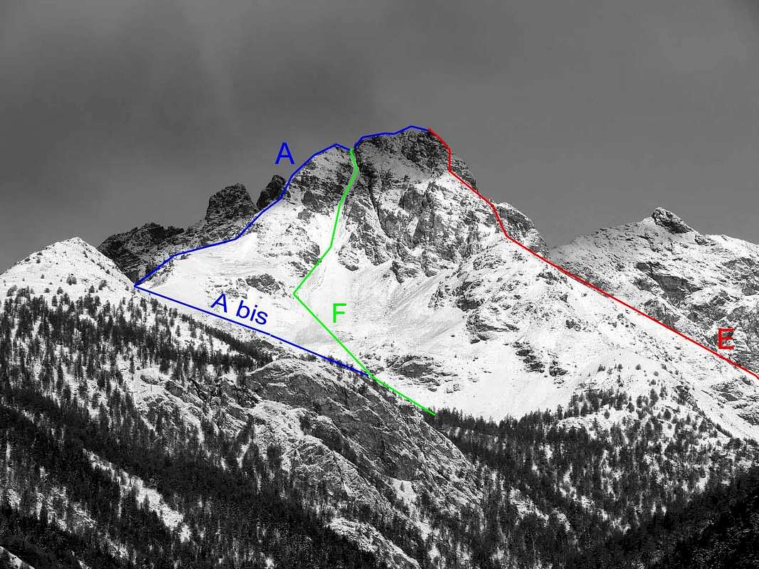
ROUTE A (From Senevé Alp towards the Tall Pass and through the South-southeast Great Crest or Standard Route also "Via" of the first slope 1912):From the Senevè Tall Pasture with direction toward Northeast, or from the intersection among the road poderale and the path n° 1 to quota 2.148 meters with direction North, to reach and to double on the left (North) the promontory above quoted exploiting a small trace of pasture; with a long diagonal among the stony ground at the base of the Southern Slope of the Great S-SE Crest of the West Antetop of the Beaks of Fana to reach at times the small saddle with residual of snowy frame of the Tall Pass (2.540 meters around; good panoramic point and profit as splendid "salle à manger" (1h'00 from the Alp and 0h'50 from the alternative; 3h'30/4h'00 altogether; to pay attention in case of fresh snow or tall and soft snow, because the same is lent to form small snowlides). From the Tall Hill to go up again toward North the first part of the great Crest South-southeast reaching, after a hump elongated, small balcony in the shape of tiny rocky promontory, presenting a partition wall in the Southwest of Sénevé paid to Comba, beyond which, after a small depression comma-shaped (in the beginning of the season usually snowy), the crest mostly feathers him; with linear slope, to the border of the Slope Southwest of the West Antesummit of the Beaks of Fana, to go up again through mixed rocky steps to grassy and brief lines debris small couloirs that brings to the West Antecima or Western Ante Summit (2.945 meters around). From this, come down to a small Carving 2.930/2 meters about, to go up again with non difficult climb (II°/II°+ and I°+; you see photo in climbing) but delicate for the bad quality of the rock to the Central Beak, the most elevated (1h'15).
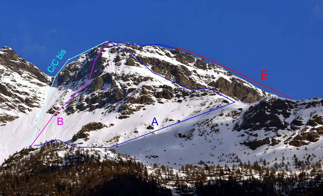 |
VIA A(Dall'Alpeggio di Senevé attraverso il Passo Alto e per il Crestone Sud-sudest Via Normale o del primo salitore 1912):
Dall'Alpe di Senevè con direzione verso Nordest, o dall'intersecazione tra la strada poderale ed il sentiero n° 1 a quota 2.148 metri con direzione Nord, raggiungere e doppiare sulla sinistra (Nord) il promontorio sopraccitato sfruttando una piccola traccia da pascolo; con un lungo diagonale tra la pietraia alla base del Versante Meridionale del Crestone Sud dell'Antecima Ovest dei Becchi di Fana raggiungere la selletta con a volte residui di cornice nevosa del Passo Alto (2.540 m~; ottimo punto panoramico ed utile come splendida "salle à manger" (1h'00 dall'Alpe e 0h'50 dal bivio; 3h'30/4h'00 in totale; prestare attenzione in caso di neve fresca o di neve alta e molle, perché lo stesso si presta a formare piccole slavine). Dal Passo Alto risalire verso Settentrione la prima parte della grande Cresta Sud-sudest raggiungendo, dopo una gobba allungata, un piccolo balcone roccioso a forma di minuscolo promontorio, presentante a Sudovest una paretina rivolta alla Comba di Senevé; oltre il quale, dopo un piccolo avvallamento a forma di virgola (in inizio di stagione in genere innevata), la cresta si impenna maggiormente. Con salita lineare, al margine del Versante Sudovest dell'Antecima Ovest dei Becchi di Fana, risalire per mezzo di gradini rocciosi misti a tratti erbosi e brevi canalini detritici adducenti all'Antecima Ovest (2.945 m~). Da questa, discesi ad un Intaglietto roccioso 2.930/2 m~, risalire con arrampicata non difficile (II°/II°+ e I°+; vedi foto in arrampicata) ma delicata per la cattiva qualità della roccia al Becco Centrale, il più elevato (1h'15).
VARIANT departing from COMBA DECHE (Route A bis):
It is possible to reach the High Pass, even starting from the Eastern Side opposite, through Comba Dèche, exactly starting from the Village of Trois Villes but not by Fraction Avisod, but from the above of Fonteil (1.423m). Using the C APPROACH reach the Alp of Clavel, or rather, from the small and tight double hairpin bend that precedes it up with the small furrow torrential West direction, which comes from a small walloon facing South-east of the secondary Beaks of Fana, follow it with cross stone and grassy sections meeting at an altitude of 2.375 meters the path n° 1 which comes from Cornet Hill and reaches the private road midway between the same pasture and that of La Seyvaz. Changing direction more towards Northwest, a hundred feet above, we find a small rocky area that supports a small moraine or snowy residue (rarely in Summer) at the base of the Beaks of Fana; overtake smoothly and gradually bending again to reach the West easily the High Hill (1h'15/1h'30, perhaps faster than the Slope of Sénevé, to whom we are most affected, perhaps especially for personal use, habitual; 2h'45/3h'00 altogether from Fonteil Hamlet).
VARIANTE con partenza dalla COMBA DECHE (Via A bis):
Sussiste la possibilità di raggiungere Il Passo Alto anche partendo dal Versante Orientale opposto, ovvero dalla Comba Dèche, pur prendendo le mosse sempre dal Villaggio di Trois Villes ma non dalla Frazione di Avisod, bensì da quella soprastante di Fonteil (1.423 m). Utilizzando l'AVVICINAMENTO C raggiungere l'Alpe di Clavel o, meglio, dal doppio e stretto tornantino che la precede procedere con direzione Ovest il piccolo solco torrentizio, che proviene da un valloncello secondario rivolto a Sudest dei Becchi di Fana; seguirlo con percorso su pietraia e tratti erbosi incontrando a quota 2.375 metri circa il sentiero n° 1 proveniente dal Col Cornet e che raggiunge la strada poderale a metà strada tra l'alpe medesima e quella di La Seyvaz. Cambiando direzione più verso Nordovest, un centinaio di metri al di sopra, si incontra una fascetta rocciosa sostenente un anfiteatrino morenico o con residui nevosi (raramente d'Estete) alla base dei Becchi di Fana; superarlo agevolmente e poggiando gradatamente di nuovo ad Occidente raggiungere facilmente il colle (1h'15/1h'30; forse più rapido che non il Versante di Senevé, al quale restiamo maggiormente legati, forse soprattutto per personale utilizzo abitudinario; 2h'45/3h'00 in totale dal Villaggio di Fonteil).
ROUTE B (From Senevé Alp through the Southwest Face of Western Ante Summit and the West-northwest Crest in terminal part):
This way is shown here only for completeness of systematic description, clockwise, as is the case for all mountain climbing guide and respecting their traditional norms. In fact turns out to be a very unwise path for the bad quality of the rock, as well as excessive exposure to falling rocks. In the one and only, probably, carried ascension was not found as above, but, in any case, remain the above observations. With the approach B to Fana Hill, climb in the direction of the large couloir that leads to it; when you reach a large rock around it on the left (do not pass on the right of the same in order to avoid exposure to falling rocks from the southernmost of the Southwest Face above the Ante Top Western) and go up in the middle of the wall of broken rock and often covered with debris and grass. Joining a small couloir on the right accompanied by an equally small and slightly marked rocky spur, which rises almost in the center of the wall. Leaving a detrital ledge on the right and oblique, which dates back to the great South-southeast ridge, continue in the center of the face and, taking advantage of the highest in the industry a short canal semi-circular convex to the right, go to the final part coming out on top of the Ante Southwest at the Top of a mound of stone (2.945 meters around).
 |
VIA B (Dall'Alpeggio di Senevé per la Faccia Sudovest dell'Antecima Ovest e la Cresta Ovest-nordovest nella parte finale):
Questa via viene esposta solo per completezza di descrizione sistematica, in senso orario, come avviene per tutte le guide alpinistiche e rispettando i loro canoni tradizionali. In realtà risulta essere un percorso alquanto sconsigliabile per la cattiva qualità della roccia, nonché per l'eccessiva esposizione alla caduta di pietre. Nella sola ed unica, probabilmente, ascensione effettuata non venne riscontrato quanto sopra descritto, ma, in ogni caso, rimangono le osservazioni sopra riportate. Con l'avvicinamento B per il Colle di Fana, salire in direzione del gran canale che porta allo stesso; giunti all'altezza di una grande roccia aggirarla sulla sinistra (evitare di passare sulla destra della medesima al fine di evitare l'esposizione a caduta di pietre dal settore più meridionale della soprastante Faccia Sudovest dell'Ante Cima Occidentale) e salire nel centro della parete su roccia rotta e spesso ricoperta da detrito ed erba. Entrare in un canalino accompagnato sulla destra da un altrettanto piccolo e poco marcato sperone roccioso, che sale pressoché nel centro della parete. Lasciando sulla destra una cengia detritica e obliqua, che risale verso la grande Cresta Sud-sudest, continuare nel centro della faccia e, sfruttando nel settore più alto un breve canale semi circolare convesso a destra, portarsi nella parte finale uscendo sulla sommità dell'Ante Cima Sudovest presso un tumulo in pietra (2.945 m~).
ROUTE C and C bis (From Senevé's Alp towards the Fana's Pass and through the Northwest Crest or the Northern Gully, this last First Winter Route):
The brief crest Northwest (70/80 meters around) that from the Fana Pass it always reaches at first the same antesummit slightly holding himself under the North Crest (it has integrally been crossed already in 1978 with more amusing slope); climbed brief and easy on broken rout. In the case of slope on the thread of crest to be foreseen the overcoming of a small vertical wall of a two weeks of meters (passages of II°+ and III°-). Other-wise, how winter variant or simply in the presence of snow, a little gully of few more than center meters on the slope North that brings to the Carving 2.930/2 meters about, between the Peak of the Maximum Top or Central Beak and the Western Ante Top; it asks for prudence in snow's presence not transformed or floury but very amusing with hard and good snow.
VIA C e C bis (Dall'Alpeggio di Senevé attraverso il Colle di Fana e per la breve Cresta Nordovest oppure il Canalino Settentrionale, quest'ultima Via della Prima Invernale):
La Cresta Nordovest che, con un dislivello di 70/80 m~ dal Colle di Fana arriva dapprima sempre alla stessa antecima tenendosi leggermente sotto la cresta a Nord (è già stata percorsa integralmente nel 1978 con salita più divertente); salita breve e facile su roccia rotta. Nel caso di salita sul filo di cresta da prevedere il superamento di un piccolo muro verticale di una quindicina di metri (passaggi di II°+ e III°-). Oppure, come variante e sicuramente meglio in inverno od in presenza di neve, un canalino di poco più di centro metri sul versante Nord che porta all'Intaglio 2.930/2 m~, tra la Vetta della Cima Massima e l'Antecima Ovest; richiede prudenza in presenza di neve non trasformata o farinosa e divertente invece con neve buona e dura.
 |
 |
 |
 |
ROUTE D (From Clavel Alp towards a small secondary walloon of Dèche Basin and through the Northern Slope and the North Gully or Northwest Crest in final part):
From the Alp of Clavel (see APPROACH C) continue along the farm road "poderale" until you reach the path n° 1 that comes from Cornet's Hill, from this point to abandon it and turn decisively to the West entering a little walloon secondary content among the East Ridge of Becca Conge Becca to North, the Point Joseph Maria Henry, the Eastern Peak of Tsaat a l'Etsena in West and Beaks of Fana, at its Southern end. This forms an amphitheater far wider than the previous small and triangular walloon at the base of the Beaks of Fana (see Variant route A); go up it in its center bending progressively in the Southwest and then decidedly more towards the South in the direction of Fana Pass. More precisely: first to climb a steep debris flow that is extinguished against a "strangulating" of two rock bands; go up through a narrowing channel with broken rock debris overlying taking a "plateau" stony or snowy funnel-shaped; to continue overcome on his side left going to get a second bottleneck between the walls of the Oriental Beaks of Fana and a block and a triangular rock. Go in the middle and slightly bending first right and then left (South) to reach the Fana' Hill (2.880 meters around; 1h'30 1h'45 from the private "poderale" dirt road, in total 3h'15/3h'30 from Fonteil Hamlet; route, as already said, more dangerous than that of the Slope Sénevé, maybe, in good condition, the more rapid for the descent and the reenter to Trois Villes). From this point proceed with three possibilities:
- 1) - Climb through the Northwest Ridge route with under the same North or climbing it in full, as in the itinerary C, reaching the Ante Western Peak (2.945 meters about; 0h'30). Down to a small Carving 2.930/2 meters around climb over rocks to reach the most difficult and challenging at first a little to his left shoulder (2.940 meters around; with usually a short, snowy gully (see photo in "Dissertations and observations at the foot") through which continue, or go to the right on the ridge up climb on rocks harder to Central Beak of Fana, the more high (0h'15; 0h'45 in total from the hill and overall 4h'00/5h'00).
- 2) - Through a crossing diagonal that goes from West to East we reach a couloir, that along the way, becomes a small couloir in little more than a hundred meters on the North Slope alleging notch always 2.930/2 meters about, between the High Peak of the Top and the Western Ante Summit. Requires caution in the presence of unprocessed or powdery snow and fun instead with good snow and hard. From this point choose between the rise before the Ante Top Western or directly ascent to the Summit (more or less the same time that the previous itinerary).
- 3) - Without wanting to reach the hill, go directly into the couloir/gully and, with more tiring and tedious path in the absence of snow, reunited with the previous route (10 minutes less).
VIA D (Dall'Alpeggio di Clavel attraverso un valloncello secondario alla Comba Dèche ed il Versante Settentrionale ed il Canalino Nord o la Cresta Nordovest nel tratto terminale):
Dall'Alpe di Clavel (vedi AVVICINAMENTO C) continuare lungo la strada poderale sino ad incrociare il sentiero n° 1 proveniente dal Col Cornet; da questo punto abbandonare la medesima e svoltare decisamente ad Ovest entrando in un valloncello secondario contenuto dalla Cresta Est-sudest della Becca Conge, dalla Punta Henry, dalla Cima Est della Tsaat a l'Etsena ad Ovest e dai Becchi di Fana, alla sua estremità Meridionale. Questo forma un anfiteatro ben più vasto rispetto al precedente piccolo e triangolare vallone alla base dei Becchi di Fana (vedi VARIANTE all'itinerario A); risalirlo nel suo centro ripiegando progressivamente a Sudovest e poi decisamente più verso Sud in direzione del Colle di Fana. Più precisamente: dapprima salire una ripida colata detritica estinguentesi contro una strettoia compresa da due fasce rocciose; superatala, tramite uno stretto canalino detritico con rocce rotte, continuare portandosi ad un soprastante "plateau" detritico o nevoso a forma di imbuto; superarlo sul suo lato di sinistra salendo per raggiungere una seconda strozzatura compresa tra le pareti dei Becchi Orientali di Fana ed un isolotto roccioso di forma triangolare. Passarne nel mezzo e dispiegando leggermente prima a destra e poi a sinistra (Sud) raggiungere il Colle di Fana (2.880 m~; 1h'30/1h'45 dalla strada poderale; in totale 3h'15/3h'30 da Fonteil; itinerario, come già sovraddetto, più dangeroso rispetto a quello del Versante Senevé, forse, in buone condizioni, più rapido per la discesa ed il rientro a Trois Villes). Da questo punto proseguire con tre possibilità:
- 1) - Salire per mezzo della Cresta Nordovest con percorso sotto la medesima a Nord con alcune contornazioni oppure salendola integralmente, come nell'itinerario C, raggiungendo l'Ante Cima Ovest (2.945 m~; 0h'30). Discesi ad un piccolo Intaglio 2.930/2 m~ risalire su rocce più difficili ed impegnative raggiungendo dapprima una spalletta (2.540 metri circa; con alla sua sinistra in genere un breve canale nevoso (vedi foto in "Dissertations and observations at the foot") tramite il quale continuare; oppure salire sulla destra sul filo di cresta sino al Becco di Fana Centrale, il più elevato (0h'15; in totale 0h'45 dal colle e complessivamente 4h'00/5h'00).
- 2) - Tramite una traversata in diagonale che sale da Ovest ad Est si arriva ad un couloir che, strada facendo, diventa un canalino di poco più d'un centinaio di metri sul Versante Nord adducente sempre all'Intaglio 2.930/2 metri all'incirca, tra la Vetta della Cima Massima e l'Antecima Ovest. Richiede prudenza in presenza di neve non trasformata o farinosa e divertente invece con neve buona e dura. Da questo punto scegliere tra il salire prima l'Ante Cima Ovest o direttamente alla Sommità (più o meno stesso tempo che al precedente itinerario).
- 3) - Senza volere raggiungere il colle, salire direttamente in direzione del couloir/canalino e, con percorso più faticoso e noioso in assenza di neve, ricongiungersi con il precedente itinerario (10 minuti in meno).
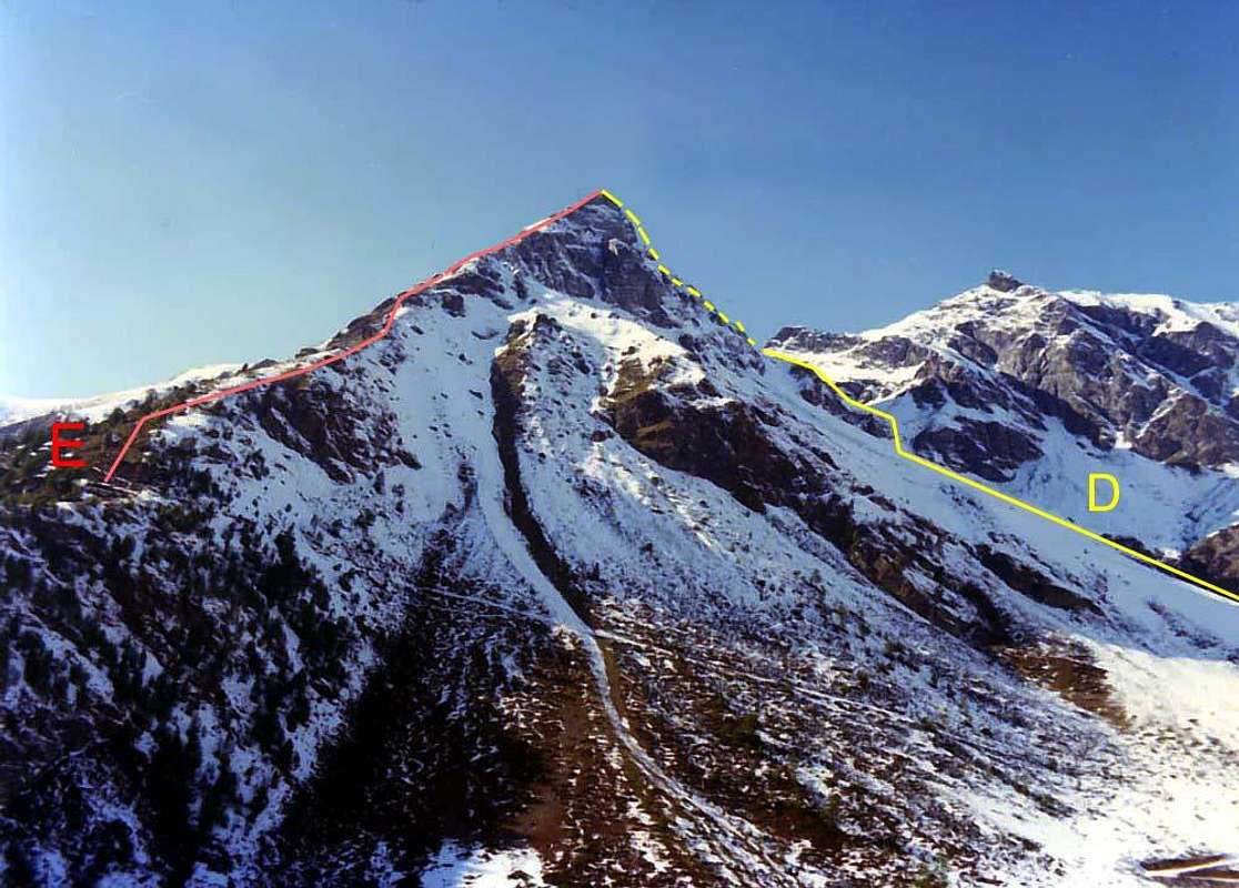 |
ROUTE E (From Clavel Alp directly by the Great Oriental Ridge or East-southeast):
From the Clavel Pasture, reachable by APPROACH C, climb along the ridge East-southeast before through a first stretch of easy rock, and almost immediately cross the path n° 1, which comes from the With Cornet, and overcome the same. From this point on the ridge, the trees become increasingly rare and the same form a rounded hump supported on the North Slope from a small rocky wall; go easily to the base of a marked pulpit rock that originates to the North-northeast in the direction of a small outcrop mouth of the small valley between the Beaks of Fana and Becca Conge. Climb for small terraces of broken rocks, bypassing the ridge on the left, coming on as a tiny fork immediately left (West) of this promontory. Reaching through rocky terrain and easier the base of the tower summit and, with a final stretch with four small jumps for a total of about 70 meters more challenging, steep and exposed, reach the Third Beak Oriental or Eastern Top of Fana (2.938 meters; 2h'15/3h'00 about, bearing in mind that the first, and perhaps the only path, was realized downhill in about 1h'45 from Oriental Eastern Beak to Alp Clavel.
VIA E (Dall'Alpeggio di Clavel direttamente per il Crestone Orientale o Est-sudest):
Dall'Alpe Clavel, raggiungibile con l'AVVICINAMENTO C, risalire lungo la Cresta Est-sudest tramite un primo tratto di facili roccette; quasi subito incrociare il sentiero n° 1 proveniente dal Col Cornet, e superare lo stesso. Da questo punto sulla cresta gli alberi divengon sempre più radi e la stessa forma una gobba arrotondata accompagnata sul Versante Nord da una paretina rocciosa; proseguire facilmente insino alla base d'un marcato pulpito roccioso originante verso Nord-nordest uno speroncino in direzione dell'imbocco del valloncello tra i Becchi di Fana e la Becca Conge. Salire per terrazzini di rocce rotte, aggirando sulla sinistra il filo di cresta, uscendo così su d'una minuscola forcella subito a sinistra (Ovest) di questo promontorio. Raggiungere per rocce sempre rotte e più facili la base della torre sommitale e, con un tratto finale, con quattro saltini rocciosi susseguentisi, di circa 70 metri più impegnativo, ripido ed esposto, raggiungere il Terzo Becco Orientale di Fana o Becco Est (2.938 m~; 2h'15/3h'00~, tenendo presente che il primo, e forse unico percorso, é stato effuato in discesa in 1h'45~ dal Becco Est all'Alpe Clavel.
ROUTE F (From the dirt road "poderale" between Brunier's and Clavel's Pastures towards a little secondary wallon of Dèche Basin and the South-southeast Couloir):
Southeast Gully descending towards the Comba Dèche towards the Alps Clavel-Rossin-La Pesse path; fun, if faced with hard snow, and it has been carried down by the rope of 1975 downhill from Western Anter Summit, after the Fires of Peter and Paul (local tradition in Aosta Valley). The same originates between the Ante Top Western and real Beaks of Fana, at a small Carving approximately in quota 2.930/2 meters, fifteen meters wide in its most extended, seven/eight metres in the more narrowness and a little less than a quarter of a mile, can be used for a rapid descent connecting with the nearby High Pass or Passo Alto (2.540 meters about), so as to allow the return in the Basin Senevé, if used as a starting point for ascension. In addition you could also come to the bottom of the couloir along the Eastern Slope, or from the Comba Dèche; purpose see the observations made concerning the Route A in its VARIANT. From the small and morainic amphitheatre above the rock band instead of turning to the West continue on the northbound quickly reaching the mouth of the channel itself 3h'00/3h'15 in all from Fonteil Village).
 |
VIA F (Dalla strada poderale tra gli Alpeggi di Brunier e di Clavel tramite un valloncello secondario della Comba Dèche ed il Couloir Sud-sudest):
Canalino Sudest discendente verso la Comba Dèche in direzione delle Alpi Clavel-Rossin-La Pesse; percorso divertente, se affrontato con neve dura, e già effettuato in discesa dalla cordata del 1975. Lo stesso trae origine tra l'Ante Cima Occidentale ed i veri e propri Becchi di Fana, presso un intaglietto approssivamente quotabile in 2.930/2 m~; largo una quindicina di metri nella sua parte più amplia, 7/8 metri ove maggiormente si restringe ed alto poco meno di un quattrocento metri, può servire per una rapida discesa collegandosi con il vicino Passo Alto (2.540 m~), tal da permettere il rientro nella Conca di Senevé. Inoltre é possibile portarsi alla base del canale anche percorrendo il Versante Orientale, ovvero dalla Comba Dèche; all'uopo vedere le osservazioni effettuate a proposito dell'Itinerario A nella sua VARIANTE. Dall'anfiteatrino soprastante la fascia rocciosa invece di voltare ad Ovest continuare sulla direzione Nord raggiungendo in breve l'imbocco del canale medesimo 3h'00/3h'15 in totale dal Villaggio di Fonteil).
Difficulties
- Western Antesummit: EE/F+/I°. In winter even II° and danger into Couloir of Fana Pass and in the traverse on ledge of Eastern Slope.
- Central Beak: EEA/AD-/I°,II°,III°+. In winter more difficult in presence di verglass or simply ice on the rocks of edge in terminal part (60 metres about).
- WINTER BEAKS of FANA (2.950/1, 2.944/45, 2.940, 2.938 meters about) from Trois Villes Village, Senevé Vallon, FanaCouloir and Northern Slope/Couloir. See Route Number One; depending from the snow conditions.
 |
 |
 |
 |
Gear
Muntaneering: rope, helmet and crampons in winter ascent, other-wise even in snow or ice presence.Da alpinismo: Corda, casco e ramponi in caso di salita invernale od in presenza di neve e ghiaccio.
MAPS:
Campings
Remember that free camping is forbidden (except for emergency reasons, over 2.500m, from darkness until dawn).Mountain Condition
- Valle d'Aosta Meteo
- Meteo: you can find all the needed informations at the official site of the Valle d'Aosta Region:
Webcam
- WEBCAM on Aosta Valley:
- Webcam
Books and Maps
BOOKS:- "Guida della Valpelline" de l'Abbè Joseph-Marie Henry - Societè Editrice Valdotaine 1925 II Edition e Collana Reprint Musumeci (1986).
- "Guida dei Monti d'Italia - Alpi Pennine (Vol. 2)" di Gino Buscaini - Club Alpino Italiano/Turing Club Italiano, Luglio 1970 (In Italian).
- "80 itinerari di Escursionismo Alpinismo e Sci Alpinismo in Valle d'Aosta", di Osvaldo Cardellina, Ed. Musumeci, Giugno 1977 (in Italian); seconda Ed. Luglio 1981; terza Ed. Luglio 1984; (in French), prima Ed. Febbraio 1978; seconda Ed. Marzo 1980.
- "Dove andiamo in montagna? in Valle d'Aosta" di Domenico Caresio Edit. Tipografia Ferraro Ivrea, Marzo 1996.
- "Diari Alpinistici" di Osvaldo Cardellina e Indice Generale accompagnato da Schedario Relazioni Ascensioni 1964-2019 (unpublished).
 |
 |
 |
- Kompass "Breuil/Cervinia-Zermatt" Carta turistica 1:50.000.
- I.G.C. Istituto Geografico Centrale "La Valpelline" (carta n° 115) Map1:30.000.
- I.G.M. Istituto Geografico Militare - Map 1:25.000.
- L'Escursionista Ed. Rimini "Gran San Bernardo-Ollomont" (carta n° 5) 1: 25.000.
Important Information
- REGIONE AUTONOMA VALLE D'AOSTA the official site.
- FONDAZIONE MONTAGNA SICURA Villa Cameron, località Villard de la Palud n° 1 Courmayeur (AO) Tel: 39 0165 897602 - Fax: 39 0165 897647.
- SOCIETA' DELLE GUIDE DELLA VALPELLINE Etroubles-Strada Nazionale, n° 13 - Tel +39 0165 78559 - Valpelline-Loc Capoluogo, n° 1 - Tel +39 0165 713502 (AO) Italia.
- A.I.NE.VA. (Associazione Interregionale Neve e Valanghe).
Useful Numbers
- Protezione Civile Valdostana località Aeroporto n° 7/A Saint Christophe (Ao) Tel. 0165-238222.
- Bollettino Meteo (weather info) Tel. 0165-44113.
- Unità Operativa di Soccorso Sanitario Tel. 118.