

-
 4412 Hits
-
 84.27% Score
-
 18 Votes
|
|
Area/Range |
|---|---|
|
|
47.31815°N / 9.82112°E |
|
|
Hiking, Mountaineering, Scrambling, Skiing |
|
|
Spring, Summer, Fall, Winter |
|
|
7001 ft / 2134 m |
|
|
1 - Overview
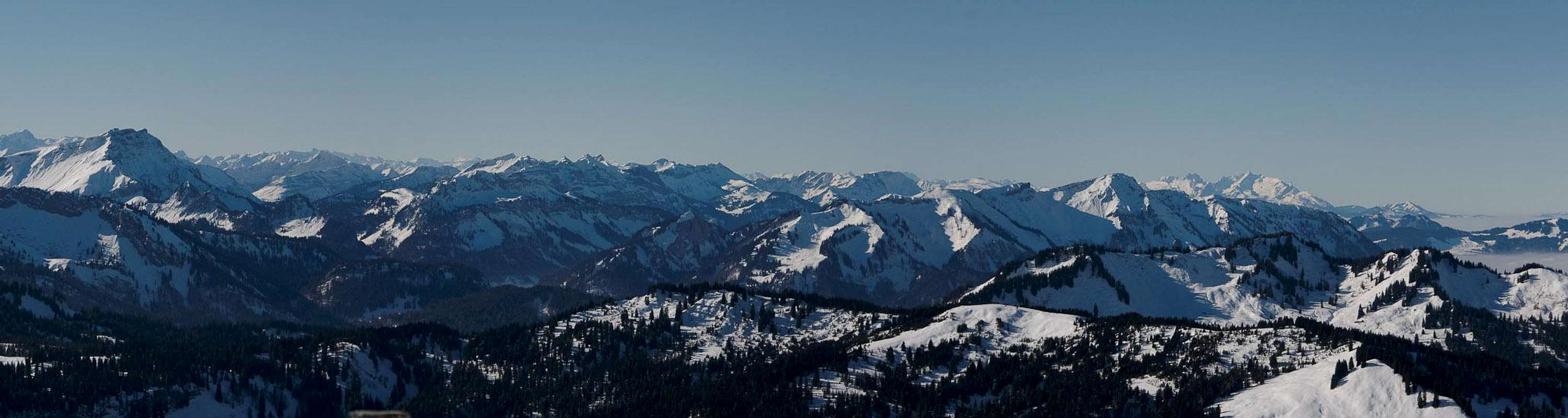
 The Bregenzerwaldgebirge in March, seen from Loch on Unter Kamor (1'420m / 4'659ft), with Hoher Freschen just left of the center
Bregenzerwaldgebirge (literally Bregenzerwald Mountains or Bregenz Forest Mountains) is a mountain group belonging to the Northern Limestone Alps as well as the Eastern Alps. It is the north-easternmost group of both greater ranges, where they run out into the pre-alpine flatlands of Germany. Though Bregenzerwaldgebirge is located very close to the borders of four countries (Austria , Germany, Switzerland and Liechtenstein) it is fully contained in Austria’s smallest state, Vorarlberg. Borders, however, are not far from the boundaries of the group.
Bregenzerwaldgebirge is a pre-alpine mountain range with only 15 mountains reaching more than 2000m. Much of the range is either covered with forests (-> name) or has been cleared of trees to make room for cattle grazing pastures. The mountains, in case they are not grass-covered knolls, stand out from the meadows for a few hundred metres at most, which is typical for the mountains of the Northern Limestone Alps.
Interestingly, limestone is rare in Bregenzerwaldgebirge. The range is made up from sediments of Subalpine Molasses and Helveticum (Helvetic Nappes) with a considerable amount of Flysch in between. Flysch is the sedimentary rock, which makes up much of the famous steep grass mountains of the neighbouring Allgäu Alps and reaches deep into Bregenzerwaldgebirge.
Speaking of neighbours, Bregenzerwaldgebirge is bounded by
- the Allgäu Alps in the east
- Lechquellengebirge in the south
- Rätikon across the Ill River Valley in the south-west
- the Appenzell Alps across the Rhine River Valley in the west (already belonging to the western Alps)
- Lake Constance (Bodensee) to the north-west
  |
The boundaries of Bregenzerwaldgebirge are a bit difficult to follow. While in the south and west they are straightforeward, in the north and east they follow a complicated sequence of small creeks and rivers, which separate the range from the Allgäu Alps.
- South: Großes Walsertal and Ill River Valley
- West: Rhine River Valley
- North:Bregenzer Ach and Subersach Valleys
- East: Subersach, Schönenbach and Osterguntenbach Valleys, Stogger Sattel, Faschinajoch
As a hiking and ski-touring destination (there is virtually no climbing in the range) Bregenzerwaldgebirge is overshadowed by its more impressive neighbours. Even Lechquellengebirge, itself not exactly a popular destination is far more popular than our small range. Bregenzerwaldgebirge is rather more famous for rather relaxed skiing in winter. There are large ski runs in the range’s centre at Damüls, Mellau and Faschina with smaller ones at Alberschwende, Schwarzenberg and Andelsbuch in the north and Breitenwald in the south. Many of the summits can be scaled by skis or snowshoes in winter, while almost all can be hiked to in the summer months. Thanks to the low altitude the hiking season already starts in early May.
 |  |  |
The most important summits of the group are located in the south-east, where it borders Lechquellengebirge. At 2134m Glatthorn is the range’s highpoint in the very soth-east. To its north you will find the ski slopes of Damüls with the corresponding subgroup, Damülser Berge, the subgroup with most 2000ers in the whole range. Main attraction, however, is Hoher Freschen, at 2004m, one of the lower 2000ers of Bregenzerwaldgebirge. Together with neighbouring Hohe Matona and its south-east running ridge (Matonagrat) it is the most popular mountain of the range. With the Binnelgrat north ridge and the Valülagrat west ridge it is home two the two most difficult, but protected hiking routes of Bregenzerwaldgebirge.
2 - Bregenzerwaldgebirge on SP
Note: So far Bregenzerwaldgebirge was one of the few blind spots on SP’s map of the Eastern Alps. Years back I considered submitting a page for it in the hope of kickstarting the SP-development of the range. Having never climbed a single mountain in Bregenzerwaldgebirge I refrained from posting, however. Two years ago, things changed. I climbed the highest mountain of Walserkamm, Tälispitze, at exactly 2000m one of the highest mountains of the whole range (in fact #15 on the list). A year later, Tijs submitted Hoher Freschen so that now we have a bit to show about the range. Still, it took me a year to finally finish the project.
- Mittagfluh and Bizauer Hirschberg
- Hinteregger Grat and Winterstaudenkamm
- Schneiderkopf and Lorenaberge
- Hochälpelekopf and Weißenfluh
- Schuttannen and Ebniter Berge
- Dornbirner First
- Kugelkamm and Hörnlegrat
- Freschen Group and Matonagrat
- Walserkamm and Falbengrat
- Damülser Berge and Kanisfluh
- Glatthorn Group
3 - The Summits
 |
3.1 Mittagfluh and Bizauer Hirschberg
- Mittagsfluh (1637m)
- Auf der Platte (1555m)
- Gopfberg (1316m)
- Hirschberg (1834m)
3.2 Hinteregger Grat and Winterstaudenkamm
- Hälekopf (1614m)
- Luguntenkopf (1702m)
- Sienspitze (1600m)
- Tristenkopf (1741m)
- Hasenstrick
- Winterstaude (1877m)
- Hohe Kirche (1747m)
- Büllerschkkopf (1761m)
- Nagelkopf (1693m)
- Patennerkopf (1385m)
- Stellerhöhe (1347m)
3.3 Schneiderkopf and Lorenaberge
- Schneiderkopf (971m)
- Brüggelekopf (1182m)
- Geißkopf (1198m)
3.4 Hochälpelekopf and Weißenfluh
- Weißenfluh (1367m)
- Hochälpelekopf (1463m)
- Am Lank (1368m)
3.5 Schuttannen and Ebniter Berge
- Kapf (1153m)
- Strahlkopf (1368m)
- Wendkopf (1532m)
- Bocksberg (1461m)
- Schwarzenberg (1475m)
- Hoher Knopf (1092m)
- Staufen (1465m)
- Breitenberg (1105m)
- Karren (971m)
- Brentenkopf (837m)
3.6 Dornbirner First
- Hangschachen (1399m)
- Hangspitze (1716m)
- Hangköpfle
- Leuenkopf (1830m)
- Mörzelspitze (1830m)
- Salzbodenkopf (1765m)
- Sattelspitz (1562m)
- Alpkopf (1768m)
3.7 Kugelkamm and Hörnlegrat
- Dümelekopf (1523m)
- Hörnle (1581m)
- Vorderhörnle (1656m)
- First (1617m)
![]()
![]()
- Hohe Kugel (1645m)
![]()
- Bühel (1200m)
- Hohe Lug (973m)


3.8 Freschen Group and Matonagrat
Valüragrat, Hoher Freschen (2004m) and Matona (1998m, the rightmost peak, with the snow patches)
 and Matona (1998m)")
- Hoher Freschen (2004m)
![]()
- Falben (1793m)
- Nob (1785m)
- Schusterstuhl (1917m)
- Riesenspitze (1773m)
- Matona (1998m)
- Gerenfalben (1938m)

3.9 Walserkamm and Falbengrat
Hochgerach (1985m), Rappenköpfle (1864m), Kopes (1735m), Dünser Horn (1615m), Muttkopf (1594m)
, Rappenköpfle (1864m), Kopes (1735m), Dünser Horn (1615m), Muttkopf (1594m)")
- Muttkopf (1594m)
- Dünser Horn (1615m)
- Köpes (1735m)
- Rappenköpfle (1864m)
- Hochgerach (1985m)
- Hüttenkopf (1976m)
- Kuhspitze (1964m)
- Tälispitze (2000m)
![]()
- Melkspitze (1936m)
![]()
- Kreuzspitze (1944m)
![]()
- Gerenspitze (1871m)
- Mutabellspitze (1933m)
- Löffelspitze (1962m)
- Grenzspitze (1879m)
- Mont Calv (1804m)
- Falykopf (1849m)


3.10 Damülser Berge and Kanisfluh
- Portalkopf (1905m)
- Portalhorn (2010m)
- Schafberg (1806m)
- Sünser Spitze (2061m)
- Ragazer Blanken (2051m)
- Hochblanken (2068m)
- Lohes Licht (2009m)
- Damülser Mittagspitze (2095m)
- Bettlerkopf (1822m)
- Wannenkopf (2006m)
- Gungern (2053m)
- Klippern (2086m)
- Hoher Stoß (1806m)
- Holenke (2044m)
- Runder Kopf (2014m)
- Sonnenspitz (1965m)
- Häle (1510m)
- Wirmsäule (1534m)
3.11 Glatthorn Group
- Türtschhorn (2096m)
- Sonnenköpfle (1877m)
- Glatthorn (2134m)
- Damülser Horn (1929m)
- Hahnenkopf (1772m)
4 - Getting There
 Bregenzerwaldgebirge seen from Mondspitze across the Ill River Valley
You can reach Bregenzerwaldgebirge easiest from the west and south from motorway A14, which connects the Lake Constance Area with Inntal Valley through the Arlberg Tunnel.
- From Germany you reach the area by taking motorway A96, which turns into A14 after crossing the Austrian border north of Bregenz.
- From Austria (Innsbruck) take Inntal Motorway A12 west until its end east of St. Anton. Cross Arlberg Tunnel after which the road turns into A14 near Bludenz.
- From Switzerland there is no direct motorway connection as Swiss A13 and Austrian A14 run in parallel on either side of the Rhine River. Cross the river either near Bregenz or Feldkirch.
5 - Accommodation
 Gassner Alm
Basically you will have to decide whether you want to spend your vacation in one of the towns to the west Bregenzerwaldgebirge or in the small villages in the remainder of the range. Offerings will be rather different as you will see as you browse the following list:
- Bregenz accommodation
- Dornbirn accommodation
- Feldkirch accommodation
- Grosses Walsertal accommodation
- Damüls – Faschina accommodation
- Au – Schoppernau accommodation
Mountain Huts
There are only three huts in Bregenzerwaldgebirge. The following links will head you to more information on the site of the Austrian alpine club:
- Freschenhaus (1846m)
- Hochälpelehütte (1460m)
- Lustenauer Hütte (1225m)
6 - Red Tape
Basically there is no red tape. However, the whole valley of Großes Walsertal has been declared Biosphere Preserve according to UNESCO’s MAB – programme (Man and Biosphere Programme). It does not only protect the natural but also cultural heritage of the encompassing area. For more information see7 - Weather Conditions
8 - Maps & Books
Kompass has some very good overview maps, scaled 1:50000 which show all the necessary trails but don't go into too much detail:
- Bregenzerwald, Westallgäu
Kompass Map WK2
1:50000
ISBN: 978-3854910039
- Bregenzerwald- und Lechquellengebirge alpin
D. Seibert
Alpenvereinsführer
Rother Verlag
ISBN: 978-3-7633-1095-1
- Bregenzerwald
B. Schäfer
Kompass Verlag
ISBN: 978-3850263818
- Bregenzerwald
H. Mayr
Rother Verlag
ISBN: 978-3763340880