
-
 37798 Hits
-
 91.89% Score
-
 37 Votes
|
|
Area/Range |
|---|---|
|
|
47.29000°N / 10.60000°E |
|
|
Hiking, Mountaineering, Scrambling, Via Ferrata, Skiing |
|
|
Spring, Summer, Fall |
|
|
9961 ft / 3036 m |
|
|
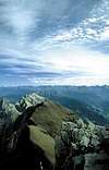
Overview
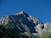
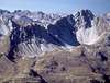
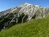
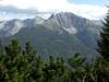
The Lechtal Alps, which are part of the northern Limestone Alps, are located just south of the Austrian / German border between the Lechtal and Inntal Valley. The range is long stretched and runs from south-west to north-east in multiple ridges. Like most of its surrounding brethren the group is home to some very impressively formed peaks and the single 3000er of the whole northern Alps - Parseier Spitze. Though easily accessible by car the group is nevertheless remote enough to offer a lot of solitary hikes and climbs – many more than any of its neighbours.There are only about 15 popular mountains in the group, most of them located close to one of the nearby villages, some placed at the end of the deep cut valleys. More than 90% of all summits of the group see only 10% or less of all mountain traffic. All require alpinist experience with steep rocky climbs along the often huge (300+m) summit blocks. The normal routes however, though often very exposed, scarcely exceed UIAA II, meaning heavy scrambling or easy climbing.
The nearest ones are the Allgäu Alps to the north, Wettersteingebirge and Mieminger Kette to the east, the Ötztal Alps to the south-east and the Samnaun- and Verwall Groups to the south-west and the rather insignificant Lechquellengebirge to the west. The boundaries of the group are well defined – as said above the Lechtal Valley bound the group from one side – the north, while the Inntal Vally snugs up from the south. To the west the upper Lechtal Valley and Arlberg Pass bound the range whereas Fernpass is the eastern boundary towards Wetterstein.
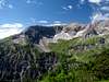
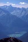
Though widly unknown the Lechtal Alps are the largest and to a certain degree most important group of the northern limestone Alps. In addition to Parseier Spitze there are roughly 40 summits with more than 2700m elevation whereas most of the other ranges can only boast 4 to 6 summits of that height. The range is very wild looking – very steep faces with narrow, gorge-like valleys made it almost inaccessible in past centuries. Consequently not much extensive farming has developed there – quite in contrast to almost any other region of the Alps. Pastures are scarce and many of the summit ascents are severe climbing affair. Consequently, to-date there are only two mountains up on SP, Parseierspitze and Dremelspitze.
Geologically you can find a whole range of different rock types in the Lechtal Alps. The tops of the range are often made up of main dolomite, which is a very brittle type of rock – at once forming bizarre towers and huge scree fields beneath. Several kinds of (high quality) limestone make up most of the other summits but in some regions you can find marl and even sandstone, the latter having swum up from the foundations of the range in which nowadays you can find different kinds of shist or eruptive rocks.
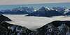
Touristically the group is (almost) of limits in winter. It is prone to avalanches which often rumble down far into the valleys. Ski touring should only be considered in secure conditions. Exceptions are the north-easternmost and south-westernmost areas of the range - around Reutte and around St. Anton.
Famous is Lechtaler Höhenweg the traverse of the group from Lech in the West to Fernpass in the east. It is a multiday trekking tour wich connects the mountain huts with each other. There are multiple variants, which often are even more solitary than the general route.
360° Panorama

The Lechtal Alps on SP
  |
The Lechtal Alps decompose into a set of often widely varying subgroups. There are no distinctive ridgelines like in most of the Alpine Groups, the gorge-like valleys criss-cross the range. The group is formed like a long and wide bent rectangle with subgroups running in all directions. The following Grouping has been taken from the Alpenvereinsführer Book, mentioned in the Maps & Books sections at the end of the page.
1 - Thaneller and Lorea Groups
Taneller is a solitary located mountain, which often is named in conjection with the small group around Loreakopf (2471m). The latter is one of the more popular summits of the Lechtal Alps, mostly because of the central location between Berwang, Namlos and Fernpass. The mountains of this subgroup are mostly made out of main dolomite rock.- Thaneller (2341m)
![]()
- Achseljoch (2020m)
- Alpkopf (1802m)
- Grubigstein (2233m)
![]()
- Gartnerwand (2377m)
![]()
- Pleisspitze (2225m)
- Roter Stein (2366m)
![]()
- Kamp (2014m)
- Steinmandlspitze (2347m)
- Suwaldspitzen (2155m, 2159m)
- Joch (Sonnberg, 2052m)
- Hönig (2034m)
![]()
- Galtbergspitze (2391m)
- Kaminlochköpfe (2234m, 2344m)
- Kreuzjoch (2332m)
![]()
- Tagweidkopf (2408m)
- Loreakopf (2471m)
![]()
- Sittelehnerkopf (2343m)
- Karlekopf (2270m)
- Aserlespitze (2337m)
- Gamplesspitze (2325m)


2 - Liegfeist Group
The Liegfeist Group is a small Group, also located to the north-east of the Lechtal Alps. It is bounded by the Lechtal, Rotlechtal and Namlostal Valleys. Apart from its highest summits Knittekarspitze (2376m) and Schwarzhanskarspitze it is a very lonely, rarely climbed region. But that holds true for most of the Lechtal Alps.- Abendspitze (1962m)
- Galtjoch (2109m)
![]()
- Steinkarspitzen (2181m, 2215m)
- Knittelkarspitze (2376m)
- Wetterkreuz (2265m)
- Kelmerspitze (2000m)
- Dürrekopfspitze (2157m)
- Neualpspitze (2143m)
- Keil (2111m)
- Mitterkarspitze (2191m)
- Pleisjochspitze (2201m)
- Stanzacher Pleisspitze (2109m)
- Schwarzhanskarspitze (2227m)
![]()
- Mahdspitze (1963m)
- Wannenkopf (2071m)
- Schartenkopf (2053m)
- Hallanderberg (1971m)


3 - Namloser Berge and Heiterwand
This group – which spreads across the range from Lechtal to Inntal – is consists of mountains of completely different rock compositions. While many summits are made up from main dolomite there are grass summits like the Kreuzspitzen and the massive ridge of Heiterwand, which is composed of Wetterstein Limestone. This twelve peaked ridge would fit better to Mieminger Kette, Wetterstein or Karwendel. The highest summit is the Heiterwand main summit at 2639m.- Schlierewand (2217m)
- Seelakopf (2368m)
- Engelspitze (2291m)
- Kalter Stein (2145m)
- Schlierekopf (2290m)
- Rudiger (2382m)
- Geierköpfe (2303m)
- Hinterbergköpfe (2278m)
- Tschachaun (2334m)
- Imster Mitterberg (2118m)
- Namloser Wetterspitze (2553m)
![]()
- Dreiköpfe (2229m)
- Sonnenkogel (2185m))
- Ortkopf (2314m)
- Egger Muttekopf (2311m)
- Pfeilspitze (2469m)
- Rotwand (2334m)
- Mittlere Kreuzspitze (2496m)
- Elmer Kreuzspitze (2480m)
- Tauberspitze (2298m)
- Elmer Muttekopf (2350m)
- Stanzacher Steinmandl (1909m)
- Habart (2294m)
- Hochpleisspitze (2349m)
- Falschkogel (2388m)
- Maldongrat (2544m)
- Steinmandl (Gabelspitze, 2581m)
- Östliche Steinmandlwand (2507m)
- Kienberg (2196m, 2218m)
- Alpeilspitzen (2521m, 2552m)
- Tarrentonspitze (2608m)
- Heiterwand (2639m, 2471m)
![]()
- Rauhberg (2480m)
- Sinnesjoch (2273m)
- Alpleskopf (2258m)


4 - Muttekopf and Parzinn Groups
To the north-west of Imst you can find the Muttekopf and Parzinn Groups which are both deeply interconnected. The summits all consist of main dolomite with its very broken appearance. There are quite a number of huts in this subgroups and the cable car from Imst ensures that it is more crowded than most of the other Lechtal Alps subgroups. Highest summit of this group is Große Schlenkerspitze (2827m).- Vordere Platteinspitze (2562m)
- Hintere Platteinspitze (2723m)
- Hinterer Sparketkopf (2632m)
- Hahnleskopf (2418m)
- Maldonkopf (2632m)
- Hinterer Scharnitzkopf (2554m)
- Muttekopf (2774m)
![]()
- Klammenspitzen (2668m, 2600m)
- Kübelspitze (2661m)
- Seebrigköpfe (2660m, 2656m)
- Rotkopf (2692m)
- Pleiskopf (2560m)
- Mannkopf (2171m)
- Ödkarlekopf (2565m)
- Larsenngrat (2323m)
- Laggers (2328m)
- Brunnkarspitze (2609m)
- Große Schlenkerspitze (2827m)
![]()
- Reichspitze (2590m)
- Hanauerspitze (2553m)
- Bergwerkskopf (2728m)
- Grubigjoch (2586m)
- Dremelspitze (2733m)
![]()
- Schneekarlespitze (2641m)
- Spiehlerturm (2550m)
- Parzinntürme (2582m, 2590m)
- Steinkarspitze (2650m)
- Gufelköpfe (2426m)
![]()
- Mittelkopf (2390m)
- Parzinnspitze (2613m)
![]()
- Kogelseespitze (2647m)
- Plattigspitzen (2558m)
- Kogelgrat (2318m)
![]()
- Bockkarspitzen (2602m)
- Potschallkopf (2587m)
- Riefenköpfe (2306m, 2282m)
- Hochgwas (2365m)
- Spitzkopf (2346m)
- Seitekopf (2344m)
- Zirmebenjoch (2407m)
- Lichtspitze (2356m)


5 - Madriol, Roßkar and Grießtal Groups
In contrast to the above mentioned Muttekopf and Parzinn Groups this thrice divided subgroup is again one of the lonliest of the whole Lechtal Alps Range. Only five summits can be reached by mountain paths – all the others are reserved for experienced climbers. The long access routes ensure loniless even more. The highest summit of this group is Leiterspitze (2750m).- Hintere Gufelspitze (2617m)
- Roßkarspitze (2660m)
- Bittrichkopf (2698m)
- Gebäudspitze (2703m)
- Schönpleisköpfe (2549m)
- Vileidspitzen (2610m)
- Kreuzjochspitze (2672m)
- Silberspitze (2461m)
- Schafhimmelköpfe (2720m)
- Leiterspitze (2750m)
- Medriolkopf (2664m)
- Schieferspitze (2735m)
- Großbergspitze (2657m)
- Großbergkopf (2612m)
- Spießrutenspitzen (2703m, 2700m)
- Landschaftsspitze (2507m)
- Landschaftseck (2610m)
- Schafkopf (2420m)
- Mittagspitze (2380m)
- Grüntalspitze (2399m)
- Torspitzen (2622m, 2611m)
- Roßkarturm (2614m)
- Großstein (2632m)
- Große Schafkarspitze (2532m)
- Hirschleskopf (2047m)
- Kleine Schafkarspitze (2338m)
- Zwickspitzen (2302m)
![]()
- Karlesspitze (2378m)
![]()
- Wannenspitze (2367m)
![]()
- Seebleskarspitze (2539m)
- Zwölferspitze (2594m)
- Ruitelspitzen (2580m)
![]()
- Gartenspitze (2331m)


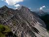
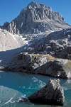
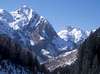
6 - Parseierspitze Group
Most compact of all the subgroups this might bet he smallest group but it is home to almost all the highest mountains of the Lechtal Alps. The highest summit is the highest mountain of the whole range, the highest one of the whole northern limestone Alps, the only 3000er – in short: Parseierspitze (3036m). In this subgroup you find remnants of glaciers, though very small and vanishing ones. Almost all rock types, which make up the Lechtal Alps can be found here: main dolomite, different kinds of limestone and marl, out of which the highest summits are made up. Access routes are very long instead of the fact that the group is tiny.- Oberlahmspitze (2658m)
- Kleinbergspitze (2756m)
- Schwabenkopf (2701m)
- Seeschartenspitze (2705m)
- Edelrautenspitze (2450m)
- Seeschartenkopf (2664m)
- Seeköpfe (2718m, 2702m, 2685m)
- Seeköpfl (2562m)
- Seekogel (2412m)
- Parseierspitze (3036m)
![]()
- Gatschkopf (2945m)
![]()
- Simeleskopf (2804m)
- Bankahorn (2822m)
- Wannenkopf (2821m)
- Oberer Rauhekopf (2811m)
- Dawinkopf (2968m)
- Feuerköpfe (2827m)
- Eisenspitze (2859m)

7 - Freispitz Ridge
Also very small and very high, the Freispitz Ridge with ist surrounding mountains is located to the far south of the Lechtal Alps. Like in the Parseierspitze Group you find a lot of different types of rocks. Access routes are long, summits are lonely.- Grießmuttekopf (2807m)
- Schwarzlochkopf (2739m)
- Stierlochkopf (2788m)
- Grießlspitze (2830m)
- Grießkopf (2814m)
- Rotspitze (2837m)
- Rotplatte (2831m)
- Freispitze (2884m)
- Saxerspitze (2690m)
- Stierkopf (2589m)
- Samspitze (2624m)
8 - Wetterspitz and Vallesin Groups
This group again stretches across the whole width of the Lechtal Alps Range. Again, in this group you will find some of the highest summits of the whole range. Only seven summits can be reached by mountain path the remainder will see only few ascents each year. The highest mountain is Holzgauer Wetterspitze at 2895m.- Vorderseespitze (2889m)
![]()
- Feuerspitze (2852m)
![]()
- Fallenbacherturm (2704m)
- Fallenbacherspitze (2723m)
- Greitjochspitze (2319m)
- Holzgauer Wetterspitze (2895m)
![]()
- Etlerkopf (2693m)
- Pleiskopf (2670m)
- Tajaspitze (2538m)
- Sonnenkögel (2324m, 2204m)
- Alplespleisspitze (2655m)
- Guflesspitze (2577m)
- Guflekopf (2563m)
- Rotschrofenspitze (2588m)
![]()
- Hahnleskopf (2210m)
- Grießtalerspitze (2622m)
- Peischelspitze (2424m)
- Zwölferkopf (2314m, 2310m)
- Furglerspitze (2592m)
- Aperriespitze (2588m)
- Kridlonspitze (2494m)
- Grießkopf (2581m)
![]()
- Malatschkopf (2388m)
- Bergleskopf (2577m)
- Schindlekopf (2471m)
- Kaisersteinspitze (2347m)
![]()
- Stanskogel (2757m)
![]()
- Vallesinspitze (2769m)
- Zwölferspitze (2511m)


9 - Valluga Group and Northern Ridges
This is the western end of the Lechtal Alps. Though the torist villages of Lech, Zürs and St. Anton are nearby, nevertheless most of the summits won’t be climbed often. Still this is the subgroup with the most ski- and chair lifts in the Lechtal Alps, making ascent routes much shorter than almost anywhere else in the range. Valluga at 2809m is the highest mountain of this subgroup. At the same time it is the European watershed draining either into the North Sea or the Black Sea (and thus the Mediterrenean).- Bacherspitzen (2640m)
- Fallersteißspitze (2634m)
- Weißschrofenspitze (2752m)
- Lorfekopf (2689m)
- Knoppenjochspitze (2680m)
- Verborgener Pleiskopf (2347m)
- Schindlerspitze (2648m)
- Galzig (2184m)
- Jahnturm (2660m)
- Valluga (2809m)
![]()
- Pazielfernerspitzen (2712m)
- Trittkopf (2720m)
- Roggspitze (2747m)
- Erlispitzen (2631m, 2634m)
- Fanggekarspitze (2640m)
- Kuglaspitze (2675m, 2684m)
- Schmalzgrubenspitzen (2643m, 2605m)
- Schmalzgrubenköpfe (2494m, 2512m)
- Gsteinspitze (2472m)
- Schwarzer Kranz (2494m)
- Pimig (2406m)
![]()
- Trittwangkopf (2482m)
- Gümplespitze (2518m)
- Rüfispitze (2640m)
![]()
- Rüfikopf (2362m)
- Rauherkopf (2520m)
- Krabachspitze (2522m)
- Lärchspitze (2393m)
- Wösterspitzen (2537m, 2557m, 2558m)
![]()
- Wösterhorn (2310m)
- Rappenspitze (2472m)
- Mittagspitze (2370m)
- Höllenspitze (2362m)


Getting There
Access to the group is a bit more difficult than for most of the other groups of the northern limestone Alps. While the Inntal Valley to the south of the group can be reached easily from either side (motorway E60) only the far west and far east of the range can be easily reached by car. Lechtal Valley itself is accessible from Reutte while the eastern access from Bregenz is long and complicated. The following itineraries concentrate on the fastest access to the group. The closest airports are Innsbruck, Munich and Stuttgart.Take motorway A12/E60 west. For southern access to the Lechtal Alps remain on the motorway until you reach your destination. For the eastern and northern access leave at Telfs for B189 to Nassereith, where you leave for B171 across Fernpass to Reutte. At Reutte you can take B198 into Lechtal Valley for the northern access.
From the airport take A92 to Munich. There take the ringmotorway to the west until you reach the exit leaving for Garmisch (A95). At Garmisch take B23 west which on the Austrian side of the border turns into B187, reaching Leermoos. Turn onto B179 north or south depending on your final destination.
Take Motorway A8 east until you reach Ulm. There turn onto A7 south, which ends near Füssen. There take the border tunnel (B179) which will take you to Reutte. From there take B198 for Lechtal Valley or stay on B179 direction Fernpass.
- Alternative
At Memmingen leave A7 for A96, direction Bregenz. In Austria the motorway is called A14 and leads to Bludenz, from where you follow Klostertal in the direction of St. Anton.
Red Tape
There are a couple of smaller natural preserves in the Lechtal Alps though – unlike most of the other ranges in the area – there is no all-encompassing natural park here. Still the usual rules apply – leave plants and animals in their habitat, keep dogs on leash, stay on trails, take refuse with you.Mountain Huts And Refuges
Huts
Though there are quite a number of huts (and few pastures) in the range access routes to most of the mountains are long and sometimes cumbersome.
| Refuge / Hut | Height | Summer | Winter | Tel. | Thumbnails |
| Wolfratshauser Hütte | 1751m | mid June – mid Oct. | Christmas – beg April | +43/664/9058920 | |
| Loreahütte / O. Reinhardt Hütte | 2022m | June – Sept. Selfservice | closed | +49/89/438944 | 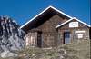 |
| Reuttener Hütte | 1715m | all summer | weekends | +43/676/4351969 | |
| Anhalter Hütte | 2038m | mid June – beg Oct | closed | +43/664/4618993 | |
| Heiterwandhütte | 2017m | all summer | all winter | +49/741/23614 | |
| Latschenhütte | 1623m | mid May – end Sept. | closed | +43/5412/65413 | |
| Muttekopfhütte | 1934m | mid June – end Sept. | closed | +43/664/1236928 | |
| Hanauer Hütte | 1922m | mid June – beg. Oct. | closed | +43/664/2669149 |  |
| Steinseehütte | 2061m | end June – end Sept. | closed | +43/664/4036451 |  |
| Würtemberger Haus | 2220m | July – mid Sept. | closed | +43/664/4401244 | |
| Memminger Hütte | 2242m | end June – end Sept. | closed | +43/5634/6208 | |
| Augsburger Hütte | 2289m | July – Sept. | closed | +43/5442/63604 | |
| Fritzhütte | 1727m | June – beg. Sept. | closed | +43/5447/52900 | |
| Ansbacher Hütte | 2376m | July – Sept. | closed | +43/5442/66713 | 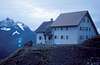 |
| Simmshütte | 2002m | end June – beg Oct. | closed | +43/664/4840093 | |
| Edelweißhaus | 1544m | all summer | all winter (no Nov.) | +43/5633/5602 | |
| Kaiserjochhaus | 2310m | July – Sept. | closed | +43/664/4353666 | |
| Leutkircher Hütte | 2261m | July – Sept. | closed | +43/664/9857849 | |
| Ulmer Hütte | 2279m | mid July – mid Sept. | Dec. – April | +43/5446/30200 | |
| Stuttgarter Hütte | 2305m | beg. July – end Sept. | closed | +43/5583/2030 | |
| Unterälpele | 1568m | summer | closed | n.a. | |
| Gipfelhaus Grubigstein | 2028m | all summer | closed | +43/5673/2323 | |
| Bergheim Hermine | 1308m | May – Oct. | closed | +43/664/5339770 |
| Bivouac | Height | Thumbnails |
| Augsburger Biwak / R. Ritter Biwak | 2604m | 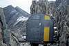 |
Accommodation
Each of the towns and villages of the area has a homepage with the possibility to book hotel rooms and apartments. Follow one of the links below.Weather Conditions
In addition to the weather information on the sites you find under accommodation you can look up these sites:Maps & Books
Maps
- Digital Maps
- Regular Maps
- Lechtaler Alpen-Hornbachkette
Kompass Map WK 24
1:50.000
ISBN: 3-85491-025-8
- Zugspitze - Mieminger Kette
Kompass Map WK 25
1:50.000
ISBN: 3-85491-026-6
- Imst-Telfs-Kühtai
Kompass Map WK 35
1:50.000
ISBN: 3-85491-039-8
- Alpenvereinskarten of the German Alpine Club
- 2/2 Allgäuer-Lechtaler Alpen, östliches Blatt, Art.Nr.: 100002
- 3/2 Lechtaler Alpen, Arlberggebiet, Art.Nr.: 100003
- 3/3 Lechtaler Alpen, Parseierspitze, Art.Nr.: 100004
- 3/4 Lechtaler Alpen, Heiterwand, Art.Nr.: 100005
- 2/2 Allgäuer-Lechtaler Alpen, östliches Blatt, Art.Nr.: 100002
- Lechtaler Alpen-Hornbachkette
Books
- Arlberg – Paznaun
Herbert Mayr
Rother Verlag
ISBN: 3-7633-4121-8
- Pitztal
Henriette Klier / Walter Klier
Rother Verlag
ISBN: 3-7633-4058-0
- Außerfern
Dieter Seibert
Rother Verlag
ISBN: 3-7633-4055-6
- Allgäu 2
Dieter Seibert
Rother Verlag
ISBN: 3-7633-4259-1
- Lechtaler Alpen
Heinz Groth / Rudolf Wutscher
Rother Verlag
ISBN 3-7633-3261-8
- Lechtaler Alpen Alpin
Dieter Seibert
Alpenvereinsführer
Rother Verlag
ISBN 3-7633-1268-4