
-
 18035 Hits
-
 94.82% Score
-
 49 Votes
|
|
Area/Range |
|---|---|
|
|
47.21537°N / 10.02022°E |
|
|
Hiking, Mountaineering, Skiing |
|
|
Spring, Summer, Fall, Winter |
|
|
9032 ft / 2753 m |
|
|
1 - Overview
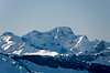
 Zuger Tal as seen from Rüfispitze Zuger Tal as seen from Rüfispitze |
The Lechquellengebirge Range, one of the westernmost mountain ranges of the eastern Alps, is grouped horse-shoe like around the sources of the river Lech, which gave it their name (translated: Lech Sources Range). The group belongs to the northern limestone Alps and – like its neighbours Bregenzerwald, Allgäu Alps and Lechtal Alps is mainly made up from Main Dolomite and Limestone with karst-like plateaus in its midst.
The Lechquellengebirge Range is roughly triangular with the southern boundary being Klostertal Valley, which separates it from the Ferwall- and Rätikon-Groups. The western boundary runs from Arlbergpass in the south across Flexenpass and Hochtannbergpass towards the villages of Schröcken and Au and separates the range from the Lechtal and Allgäu Alps. The western boundary runs from Au through the Argenbach Valley across Faschinajoch Pass into Grosswalsertal Valley and from there towards Bludenz back in Klostertal Valley. West of this boundary you find the Bregenzerwald Range
The highest mountains of the range are grouped on the horseshoe which surrounds the Lech-Sources, with the highest summits in the south-east and lower summits in the north-west. The range attracts a lot of snow and rain during the year which results in rather few visitors during the summer months but many winter guests on the ski slopes in the east of the range. There are no glaciers – again like for the surrounding ranges but huge amounts of snow accumulate and often remain on the north faces deep into June. The timberline – which regularly runs around 2000m in the Alps - drops to 1700m – 1800m in the Lechquellengebirge Range.
Except for the ski runs near Arlberg Pass, Flexenpass and Hochtannberg Pass, the range is rather solitary. Several toll roads lead deep into the range facilitating access to the remoter mountains. The highest summit is Wildgrubenspitze at 2753m, which is located in the far east of the range. Several other summits exceed 2600m but the overall elevation is rather moderate. Many of the summits are alpinist undertakings and only one – Karhorn – has been secured by a Klettersteig (ferrata). Especially the rough summits in the south of the range are off limits for hikers.
As for the name and grouping – the name has been suggested by Walther Flaig though formerly the range was known as Klostertal Alps (after the bounding valley in the south. Also, several guidebooks group the range into the Lechtal Alps, its neighbour to the east.
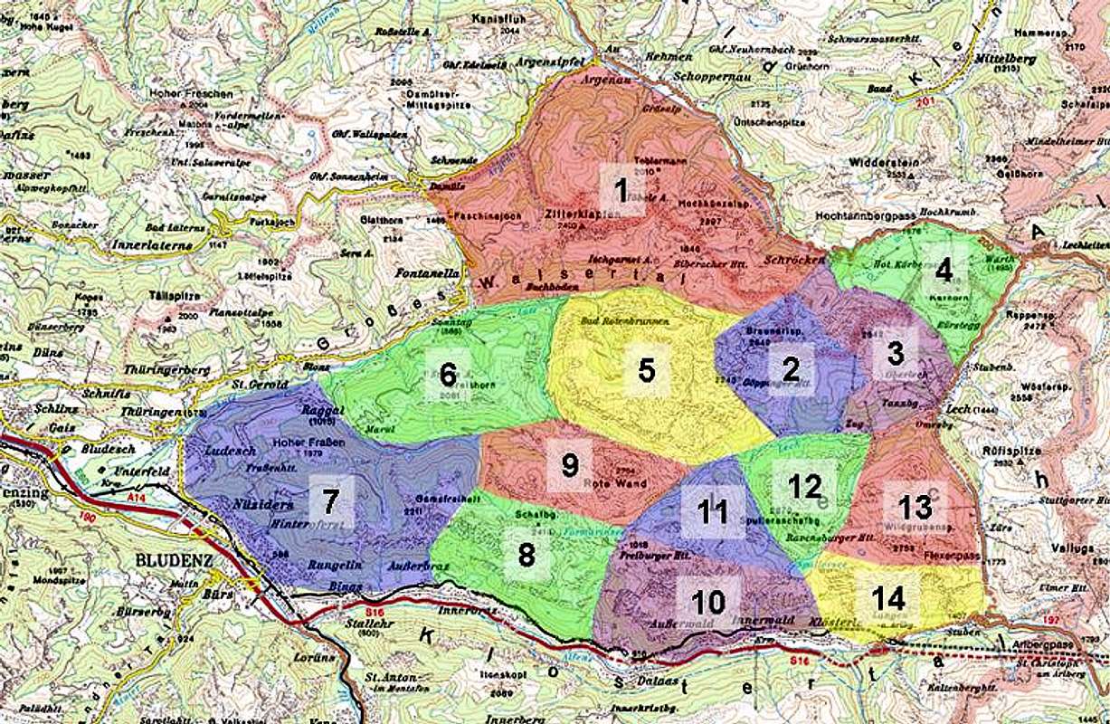
2 - Lechquellengebirge on SP
 |
The grouping follows the one proposed by the Gebietsführer Lechquellengebirge, a guidebook by the German Alpine Club which has been out of print for quite a while already. Since I don’t own a copy of the guidebook I drew the boundaries as I saw fit and which might be slightly off in several cases. I’m confident, however, that no more than a handful of summits are currently grouped to the wrong subgroup.
The map above gives an overview over the range and its subgroups. Click the numbers to be directed to the respective sections on this page.
3 - Zitterklapfen Group and Hochkünzelgrat Ridge
 Schematic Map of the Zitterklapfen / Hochkünzelgrat Group |
Zitterklapfen and Hochkünzelspitze are the main summits in the northernmost triangle of the Lechquellengebirge Range. The subgroup is separated from the rest of Lechquellengebirge by the upper Grosswalsertal Valley which connects across Hochbergsattel with the Fellbachvalley near Schröcken. The mountains of this subgroup are located on a slightly bent ridge with several smaller side ridges to the north. It is the largest of the subgroups of the whole range but its highest summit, Zitterklapfen, barely exceeds 2400m.
- Zafernhorn (2107m)
- Blasenkar (2004m)
- Hochschere (2013m)
- Zitterklapfen (2402m)
![]()
- Wildes Gräshorn (2253m)
- Grünes Gräshorn (2201m)
- Annalper Stecken (2124m)
- Kunkelspitze (2016m)
- Kilkaschrofen (2262m)
- Hörnle (2112m)
- Toblermann (2010m)
- Hochalpe (1911m)
- Schöneberg (2262m)
- Hochkünzelspitze (2397m)
- Niedere Künzelspitze (2156m)
- Giglturm (2112m)
- Glattjöchlspitze (2106m)
- Rossköpfe (2096m)
- Rothorn (2239m)
- Hochberg (2324m)
- Gemsegg (1795m)
4 - Braunarlspitze Group
 Schematic Map of the Braunarlspitze Group |
Braunarlspitze ist he highest mountain in the northern part of the Lechquellengebirge Range. Its small group, not more than a single main ridge with one side ridge, stretches between Hochbergsattel in the north and Bodenalpe in the south. The western boundary is Gamsboden, while the eastern one is Butzensee Lake. To the north of Braunarlspitze you can find a number of glacier basins, only one or two of which contain the tiny remains of glaciers still. To the south of Hochlichtspitze you find Göppinger Hütte, one of only six mountain huts in the whole range. Thanks to the hut and the proximity to the village of Schröcken, the subgroup is visited rather often.
- Hochlichtspitze (2600m)
- Löffelspitze (2663m)
- Orgelspitze (2592m)
- Braunarlspitze (2649m)
![]()
- Butzenspitze (2547m)

5 - Mohnenfluhgrat Ridge
 Schematic Map of the Mohnenfluh Group |
To the east of the Braunarlspitze Group you find another small group, the Mohnenfluhgrat Ridge. The name already indicates that this group also consists of a single ridge with a handful of mountains with two standalone summits to its south, Zuger Horn and Kriegerhorn. Thanks to the ski runs of Lech and Oberlech, the subgroup has been developed considerably with lots of ski-lifts and consequently is quite crowded in both summer and winter. All summits can be reached by paths but only the Hochlicht-, Mohnenfluh- and Kriegerhorn-Paths are marked.
- Zuger Horn (2111m)
- Kriegerhorn (2173m)
- Zuger Hochlicht (2371m)
![]()
- Mohnenfluh (2542m)
![]()
- Juppenspitze (2412m)

6 - Karhorn Group
 Schematic Map of the Karhorn Group |
To the far north-east of the Lechquellengebirge Range you can find one of the smallest subgroups of the range, the Karhorn Group. It is located in a triangle, bounded by the road from Flexenpass to Hochtannbergpass. Thanks to the skilifts at the latter pass Saloberkopf, the northernmost summit of the group, is the most visited one, while the highest one is Karhorn. Karhorn also is site of the only Klettersteig (ferrata) in Lechquellengebirge. To the south the subgroup is separated from Mohnenfluhgrat by Auenfeldsattel.
- Saloberkopf (2080m)
- Auenfelder Horn (2292m)
![]()
- Karhorn (2416m)
![]()
- Warther Horn (2256m)
- Wannenkopf (1941m)


7 - Johannes Group
 Schematic Map of the Johannes Group |
Named after twin summit of Johanneskopf – its highest mountain, this subgroup forms a horseshoe around the Matonabach Valley. Area-wise the Johannes Group is one of the largest of Lechquellengebirge and it has several summits exceeding 2500m. The subgroup is located in the midst of the whole range with Grosswalsertal bounding it to the north and the upper Lach Valley to the south. Of the main summits only Östlicher Johanneskopf can be reached by a marked hiking trail while the other mountains are reserved for alpinistic excurions.
- Postelkopf (1381m)
- Wangspitze (1873m)
- Matonakopf (2019m)
- Hutlaspitze (2034m)
- Bettlerspitze (2272m)
- Klesenzahörner(2276m)
- Gadnerköpfle (2271m)
- Misthaufen (2436m)
- Schönbühel (2152m)
- Hirschenspitze (2501m)
- Schwarze Wand (2524m)
- Westlicher Johanneskopf (2573m)
- Östlicher Johanneskopf (2508m)
- Bratschenkopf (2520m)
- Feuerstein (2271m)
- Disnerhöhe (2159m)
8 - Stafelvedergrat Ridge
 Schematic Map of the Stafelvedergrat Group |
The north-westernmost of the subgroups of Lechquellengebirge is Stafelvedergrat, a ridge which runs along the southern slopes of Grosswalsertal Valley. It is slightly curved and contains some 10 summits, the highest of which is Breithorn at 2081m. Due to its lack in elevation the subgroup is one of the least important ones in the whole range.
- Guggernüll (1736m)
- Kellaspitze (2017m)
- Breithorn (2081m)
- Wangspitze (1766m)
- Gronggenkopf (1978m)
- Garmil (1810m)
- Glattmar (1930m)
- Wandfluh (1574m)
9 - Gamsfreiheit Group
 Schematic Map of the Gamsfreiheit Group |
Above the town of Bludenz, to its east, you find three small ridges, which are combined in the Gamsfreiheit Group, named after its highest summit. Thanks to the proximity of the town you find dozens of hiking trails and most summits are easily accessible. In this group, on the slopes of Muttergsberg, there is another of the mountain huts, Muttersberghaus, which rather is a restaurant overlooking the town. Alpinistically,, this subgroup is of no importance.
- Hoher Fraßen (1979m)
- Klesiwand (1929m)
- Madelsak (1402m)
- Muttersberg (1328m)
- Breithorn (2009m)
- Elsspitze (1980m)
- Katzenköpfe (1495m)
- Stierkopf (1801m)
- Drei Türme (1673m)
- Gamsfreiheit (2211m)
- Novakopf (2093m)
- Novaspitze (2022m)
10 - Formarin-Schafberg Group
 Schematic Map of the Formarin-Schafberg Group |
Following the Gamsfreiheit Ridge in easterly direction you reach the next of the subgroups, the Formarin Scahfberg Group. It is named for its highest summit (Schafberg) together with its main feature, large Formarinsee Lake. The group consists of several sharp ridges, which drop impressively into the Klostertal Valley to the south. It is home to Freiburger Hütte, a mountain hut near Formarinsee.
- Weißes Rössle (2214m)
- Pitschköpfe (2193m, 2280m)
- Schafberg (2413m)
- Hammlender (2349m)
- Geißköpfe (2303m, 2183m, 2074m)
- Roggelskopf (2284m)
- Lusgrind (2286m)
- Otternkopf (1938m)
11 - Rote Wand Group
 Rote Wand Group
Rote Wand is a standalone mountain towering above Formarinsee in the south and Klesenzatal Valley in the north. At 2704m it is one of the highest mountains of Lechquellengebirge and sports a small vanishing glacier in a cirque underneath its north face. Rote Wand is accompanied by a handful of lower summits which basically surround it on all sides. Access to the mountain is easy via the toll road to Formarinsee from which only 900m in elevation gain are left to reach the summit.
 Schematic Map of the Rote Wand Group |
- Madratsch (2287m)
- Jungfernspitze (2212m)
- Östliches Rothorn (2357m)
- Rote Wand (2704m)
![]()
- Westliches Rothorn (2481m)

12 - Saladinagrat Ridge
 Schematic Map of the Saladinagrat Group |
Between the lakes of Formarinsee and Spullersee there is a long stretched ridge, named after its highest point Saladinaspitze. The creeks on the south side of the ridge, which drain into the Rhein River Valley erode the soil much faster than the ones draining north and east into the Danube River Valley, which effectively moves the watershed further north year by year. In the case of Saladinagrat the ridge already has been interrupted in two places, forming steep valleys. The ridge itself is quite inaccessible and with the exception of Saladinaspitze none of the summits can be accessed by hiking trails. Grafenspitze in the south is accessible by a chair lift as well as a steep hiking trail – proof of its use as ski mountain during wintertime.
- Allhöhe (2026m)
- Saladinaspitze (2230m)
- Fensterlewand (2329m)
- Rossköpfe (2144m, 2195m)
- Ganahlskopf (2314m)
- Gamsbodenspitze (2296m)
- Grafenspitze (1871m)
- Glongspitze (2243m)
- Plattnitzer Jochspitze (2318m)
- Batzigg (1833m)
13 - Gehrengrat Group
 Schematic Map of the Gehrengrat Group |
Though the Gehrengrat Group is only one of the smallest subgroups of Lechquellengebirge itc an be called the heart of the range. The sources of the Lech, after which the range has been named, are located east and west of Gehrengrat. Gehrengrat itself is a north-to-south running ridge with up to 1000m profundity above the valleys below.
- Formaletsch (2292m)
![]()
- Pöngertlekopf (2539m)
- Pfaffeneck (2539m)
- Frischenwand
- Gehrengrat (2439m)

14 - Spullerschafberg Group
 Schematic Map of the Spullerschafberg Group |
The subgroup around Spullerschafberg is among the smallest ones of the Lechquellengebirge Range. Effectively it consists of three mountains, which are interconnected by a horseshoe shaped ridge. Only the highest of the three, Spullerschafberg, can be reached by hiking trails but it is quite popular thanks to Ravensburger Hütte at its base which serves as a perfect starting point for the ascent. Moreover the Spullersee Reservoir is also polpular among tourists though you have to pay a toll to reach it by car.
- Unterer Schafberg (2407m)
- Mehlsack (2651m)
- Spullerschafberg (2679m)
![]()

15 -Wildgrubenspitze Group
 Schematic Map of the Wildgrubenspitze Group |
Wildgrubenspitze with its two summits Obere and Untere Wildgrubenspitze (sometimes Vordere and Hintere Wildgrubenspitze) is the highest mountain of Lechquellengebirge. The subbrange,, which groups around it, therefore is the most important one, containing most summits above 2500m. It can be reached from Lech, Zürs and Zug and thus is also one of the most frequented ranges. Moreover a number of ski and chair lifts lead to Zürser See, a lake in the centre of the group, one of the main tourist attractions here. Obviously the Wildspitze Group is the most accessible subgroup of the range.
- Bärenkopf (1702m)
- Stierlochkopf (2354m)
- Mittagspitze (2441m)
- Madlochspitze (2546m)
- Omeshorn (2557m)
![]()
- Obere Wildgrubenspitze (2625m)
- Obere Grättlisgratspitze (2642m)
- Untere Wildgrubenspitze (2753m)
![]()
- Roggalspitze (2673m)
- Untere Grättlisgratspitze (2700m)
- Flexenspitze (2627m)
- Hintere Hasenfluh (2544m)
- Vordere Hasenfluh (2534m)


16 - Erzberggrat Group
 Schematic Map of the Erzberggrat Group |
Erzberggrat is a long stretched and winding ridge, which stretches between Flexenpass in the east and Spullersee in the west. Its summits easily reach more than 2500m towering above Klostertal Valley 1300m underneath. Only Blasegg and Blisadona, two of the satellites to the south are easily accessible while the mountains on the main ridge are reserved for Alpinists. The villages of Stuben, Langen and Klösterle offer accommodation but the mountains form a barrier into the Lechquellengebirge Range.
- Goppelspitze (2371m)
- Rohnspitze (2495m)
- Schnauzlberg (1913m)
- Blisadona (2000m)
- Blasegg (1974m)
- Blisadonakopf (2424m)
- Blisadonaspitze (2528m)
- Wasenspitze (2665m)
- Grubenjochspitze (2659m)
- Erzbergspitze (2536m)
- Schwarzer Turm (2295m)
- Roter Turm (2147m)
- Rosskopf (2200m)
17 - Getting There
 Upper Lechtal Valley as seen from Formaletsch
Access to the group is a not difficult but rather remote. The following itineraries are from the closest international airports at Innsbruck, Stuttgart and Zürich.
- From Innsbruck
Simply take motorway A12/E60 west until you reach the Arlberg Tunnel. For the eastern part of the group leave the motorway before the tunnel, for the other parts drive through to the other side and leave at any of the exits east of Bludenz.
- From Stuttgart
Take Motorway A8 east until you reach Ulm. There turn onto A7 south. At Memmingen leave A7 for A96, direction Bregenz. In Austria the motorway is called A14 and leads to Bludenz.
- From Zürich
From Zürich take motorway A1 east to Bregenz where you cross the border into Austria. Take A14 south, which will lead you to Bludenz.
18 - Red Tape
Gross Walsertal, parts of which belong to the Lechquellengebirge Range, has been declared Biosphere Preserve by UNESCO. Moreover there are several smaller nature preserves in the range apart from which no restrictions apply. Within the preserves nature has been allowed to take over again so that typical alpine forests are re-establishing themselves again. The nature preserves are:- Gadental, 1.336 ha
- Gipslöcher Oberlech, 21 ha
- Bödener Magerwiesen, 16,5 ha
- Faludriga Nova 4, ha
As for fees and tolls - the roads to Formarinsee and Spullersee require tolls.
19 - Mountain Huts and Refuges
| Refuge / Hut | Height | Summer | Winter | Tel. | Thumbnails |
| Biberacher Hütte | 1846m | mid June – beg. Oct | winter room | +43/5519/257 | |
| Frassenhütte | 1730 | end May – mid Oct | winter room | +43/5552/67402 | |
| Freiburger Hütte | 1931m | mid June – beg Oct | winter room | +43/5556/73540 | |
| Göppinger Hütte | 2245m | mid June – mid Oct | winter room | +43/5583/3540 | |
| Muttersberghaus | 1825m | all summer | all winter | n.a. | |
| Ravensburger Hütte | 1948m | mid June – beg Oct | winter room | + 43/664/5005526 |
20 - Accommodation
Each of the towns and villages of the area has a homepage with the possibility to book hotel rooms and apartments. Follow one of the links below.21 - Weather Conditions
In addition to the weather information on the sites you find under accommodation you can look up this general site:22 - Maps & Books
22.1 – Maps
- Digital Maps
- Regular Maps
- Bregenzerwald-Westallgäu
Kompass Map WK 2
1:50.000
ISBN: 3-85491-003-7
- Bludenz-Schruns-Klostertal
Kompass Map WK 32
1:50.000
ISBN: 3-85491-035-5
- Bregenzerwald-Westallgäu
22.2 – Books
There are no guidebooks dealing solely with Lechquellengebirge. There used to be a Guidebook by the German Alpine Club but this has been out of print for a long time already.Most books are ski tour books which reflects the importance, skiing has in the area.
- Bregenzerwald
Herbert Mayr
Rother Verlag
ISBN: 3-7633-4088-0
- Arlberg – Paznaun
Herbert Mayr
Rother Verlag
ISBN: 3-7633-4121-4
- Bregenzerwald- und Lechquellengebirge
Alpenvereins-Gebietsführer
Dieter Seibert
Rother Verlag
ISBN: 3-7633-3288-8
Out of Print