
|
|
Mountain/Rock |
|---|---|
|
|
39.34560°N / 106.2536°W |
|
|
Lake |
|
|
12867 ft / 3922 m |
|
|
Overview
Buckeye Peak is the highest peak in a mass of mountains located north of Leadville and between Highway 24 on the west and Highway 91 on the east. The ranges East of Buckeye Peak are known as the Tenmile and Mosquito Ranges while the range west of Buckeye Peak is the Sawatch, but which mountain range that Buckeye Peak belongs to is unclear.One attraction of Buckeye Peak is that it makes a fairly easy and fairly safe ascent year round (in the winter months, there is one potential avalanche slope where caution must be taken). It is climbed frequently, but it not near as well known as the many 14ers that surround the peak and that are very visible from the peak. Although the ascent makes a fairly easy winter ascent, it is more aesthetic than some of the routes up the nearby 14ers. Perhaps the peak’s main claim to fame is that can be skied from the Sangree M. Froelicher Hut.
There are many easy routes up the peak, but there are also some challenging snow couloir routes as well. There are some steep cliffs about, but rock quality is unknown.
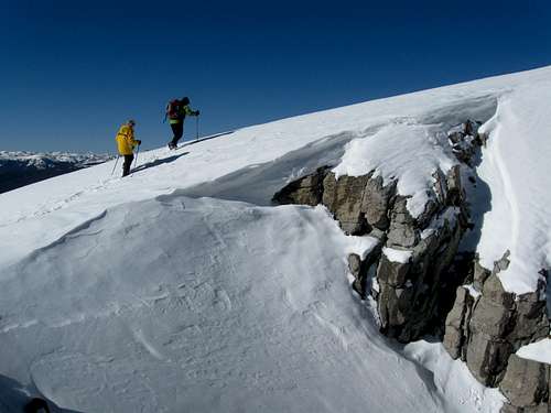 Near the summit of Buckeye Peak on November 27 2009.
Getting There
All trailheads below are open year round.Buckeye Gulch Trailhead
This is the most popular trailhead used for climbing the peak. The trailhead is north of Leadville and along Highway 91. To get to the trailhead from Leadville, from the junction of Highways 24 and 91, drive north along Highway 91 for 4.5 miles to the trailhead on the left (west) side of the road. The parking lot is marked for the 10th Mountain Division.
If coming from the north, rather than driving all the way to Leadville, drive Highway 91 south of Climax and Fremont Pass to the turnoff which is located half way between mile markers 4 and 5.
Chalk Creek Trailhead
This route makes perhaps the easiest ascent of the peak for a day climb. The trailhead is north of Leadville and along Highway 91. To get to the trailhead from Leadville, from the junction of Highways 24 and 91, drive north along Highway 91 for 8.4 miles to the trailhead on the left (west) side of the road. This is also about 3.15 miles south of Fremont Pass if you are coming from the north. The Chalk Creek Trailhead is marked with a sign.
Tennessee Pass/Ski Cooper Trailhead
This is another access route, approaching Buckeye Peak from the west. Tennessee Pass is located along Highway 24 between Minturn and Leadville. You can either park at the parking lot at Tennessee pass or Ski Cooper just to the east, depending on the season and if the ski resort parking lot is full or not.
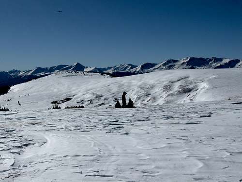 This is the broad saddle between peaks 12,156 and 12,254 on route to Buckeye Peak.
Routes Overview
There are several routes available to Buckeye Peak ranging from class 1-2 to at least class 4 in difficulty. A few of the options are outlined below.Via Buckeye Gulch
This is probably the most popular route to the peak because of its proximity to the Sangree M. Froelicher Hut. From the Buckeye Gulch Trailhead, the marked route climbs 3.5 miles to the Sangree M. Froelicher Hut. From the hut the route climbs up to the saddle between two minor peaks before following the ridge north to the summit (with several variations available). In winter, this is a reasonable route, but there is one slope where caution is advisable since it is a potential avalanche slope (which probably can be avoided with careful route finding). See the Route Page for more details.
This route is about 10 miles round trip with about 2900 feet elevation gain. This route can be completed reasonably in one day year round (in winter it can be a long day), but staying at the Sangree M. Froelicher Hut is also enjoyable.
 Resting high on the south ridge of Buckeye Peak from the Buckeye Gulch Route.
Via Chalk Creek
In winter or summer, this is probably the easiest route to make a one day ascent of Buckeye Peak. The route climbs up the east ridge of the minor peak north of Buckeye Peak. From the top of the minor peak, the ridge is followed south to the summit of Buckeye peak. In winter, this is reasonable route with mostly low avalanche danger as long as you stay on the ridgeline and don’t wander off route.
 This is Kessler approaching the highest point of the flat summit of Buckeye Peak.
Via Tennessee Pass and Ski Cooper
There is a marked ski trail from Ski Cooper to the area around Buckeye Peak. The marked ski trail joins with the Buckeye Gulch Route at around 12,200 feet. I am not familiar with the route, but it was well marked with blue diamonds on post when we did our climb. Make sure to consult a topo map when using this route (or any other for that matter).
Other Routes
The Southeast Face appears to have some great late spring/early summer snow couloirs. The East and Northeast faces are quite steep as well and should offer some challenging snow routes in the late spring/early summer season.
 This is the top of a nice looking snow couloir on the SE Face of Buckeye Peak. The couloir looks like it would make a great climb in May or June.
Red Tape
There is no red tape, so make sure to use LNT methods of travel. There is no red tape to discuss here.
Camping
There aren’t many campgrounds in the area. The closest campgrounds are at Turquoise Lake. See the link below for more information:Turquoise Lake Camping
You can also camp in the backcountry along West Fork Buckeye Gulch. Most of it is public land except for the area around the mine. There is water in West Fork Buckeye Gulch in the summer.
In the Thanksgiving through April 30 and July 1 through September 30 seasons, you can also stay at the Sangree M. Froelicher Hut. See the link below for details.
Sangree M. Froelicher Hut
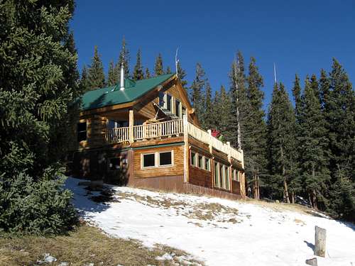 This is the Sangree M. Froelicher Hut which is on the south slopes of Buckeye Peak and at 11,650 feet elevation. It is less than 100 feet from timberline.
When to Climb
The peak can be climbed year round. All three trailheads listed above have easy year-round access.The snow free season is usually mid-June through early October. In winter, there is an avalanche slope on the Buckeye Gulch Route that requires caution. See the route page for more details. In summer, the area is very prone to thunderstorms.
 This is the Southeast Face of Buckeye Peak in late November.
Mountain Conditions
For current trail and snow conditions, more information, and access issues contact:810 Front Street
Leadville, CO - 80461
Phone (719) 486-0749
Fax (719) 486-0928
CLICK HERE FOR WEATHER FORECAST
Weather and climate data for the Climax Station at 11,360 feet elevation is below. *National Weather Service Data 1893-2012. The Climax Station is the same elevation as the slopes half way between the trailheads and the summit of the mountain and will give one a good idea of typical climate conditions in the area.
| MONTH | AVE HIGH | AVE LOW | REC HIGH | REC LOW | AVE PRECIP (in) | AVE SNOW (in) |
| JAN | 25 | 2 | 50 | -33 | 2.14 | 39.9 |
| FEB | 27 | 3 | 53 | -32 | 1.81 | 35.1 |
| MAR | 32 | 7 | 57 | -24 | 2.26 | 39.9 |
| APR | 38 | 13 | 59 | -20 | 2.48 | 39.6 |
| MAY | 48 | 24 | 71 | -10 | 1.88 | 19.4 |
| JUN | 58 | 33 | 75 | 10 | 1.31 | 4.9 |
| JUL | 65 | 39 | 79 | 12 | 2.24 | 0.1 |
| AUG | 62 | 38 | 76 | 18 | 2.22 | 0.2 |
| SEP | 56 | 31 | 74 | 6 | 1.56 | 5.7 |
| OCT | 46 | 21 | 69 | -9 | 1.37 | 17.8 |
| NOV | 33 | 10 | 60 | -27 | 1.90 | 33.2 |
| DEC | 26 | 3 | 52 | -33 | 1.99 | 37.3 |