
-
 3745 Hits
-
 79.78% Score
-
 11 Votes
|
|
Mountain/Rock |
|---|---|
|
|
46.06084°N / 9.05776°E |
|
|
Hiking, Scrambling |
|
|
Spring, Summer, Fall |
|
|
5666 ft / 1727 m |
|
|
Overview
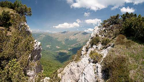 Gully between two of the summits of Cima dell'Oress Gully between two of the summits of Cima dell'Oress |
Cima dell'Oress is a mountain in the north of the Prealpi Lombarde. It is located on the border between Italy and Switzerland high above Lago di Lugano and Lago di Como, both of which can be partly seen from the summit. The mountain is located on a ridge which accompanies the eastern branch of Lago di Lugano to its north and which consists of Monte Bre, Monte Boglia, Denti della Vecchia and Cima dell'Oress before ending in its highest mountain, Cima di Fojorina.
Like its neighbours Cima dell'Oress is composed of limestone, though very brittle one. The mountain has several summits of similar height, most of which require climbing skills to get to the top. The westernmost summit, however, can be reached by a short bushwhacking scramble from a hiking trail which crosses the southern slopes. Here the main difficulty is posed by the many dwarf pines which cover the slopes.
 |  |  |
Cima dell'Oress has a very impressive north face which towers above the south slopes of Val Colla. However, unlike Denti della Vecchia to its west, rock quality is very poor. There are ledges which cross the north face and which might be interesting ascent routes if it weren't for the fact that they are also covered by the omnipresent dwarf pines. Cima dell'Oress offers some interesting views towards Monte Rosa in the west and down to the lakes beneath. The eastern views are blocked by higher Cima di Fojorina. The ridge traverse along the Swiss / Italian border from Passo San Lucio to Capanna Pairolo across the two mountains is one of the most scenic hikes in the south of Ticino / Tessin.
Getting There
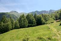
 Summit View: Monte Boglia and Denti della Vecchia
We started our hike to Cima dell'Oress from Bogno at the end of Val Colla, which requires a longish drive from Locarno, where we stayed.
- Leave the Gotthard Motorway A2 at the exit Lugano Nord.
- drive through the city, following signs to Canobbio, Sonvico and Val Colla.
- Follow the road to its very end at Bogno.
- Alternatively you can also start from Cimadera or Certara, both also located at the end of Val Colla.
Red Tape
The mountain is located on the international border between Italy and Switzerland. Though there are no customs controls anymore, carrying an ID is mandatory.Accommodation
There is plenty of accommodation to be found on the web, mainly apartments or holiday homes. However, Tessin / Ticino has become very expensive so you will have to carefully plan your vacation. Most expensive are the cities (Lugano, Locarno, Ascona) but also the villages on the shores of the lakes can burn deep holes in your pockets. In general the higher up and the better the view the more expensive.A good alternative is agritourismo - farm holidays, either in the valleys or in one of the spring / autumn settlements at an elevation of around 1000m.
You can find accomodation of any type using the following url:
http://www.ticino.ch
Weather Conditions
Maps & Books
Maps
- Digital Maps
- Regular Maps
- Malcantone
Carta Escursionistica 286 T
Ufficio Federale di Topografia Swizzeria
1:50.000
ISBN: 9783302302867
- Malcantone
Books
- Tessin
M. Hempel
Kompass Guidebook WF997
Kompass Verlag
ISBN: 3-85491-771-6
- Tessin
H. Bauregger
Rother Verlag
ISBN: 978-3-7633-4078-1
- Tessin
E.E. Hülsler
Bruckmann Verlag
ISBN: 978-3-7654-3653-6