
|
|
Mountain/Rock |
|---|---|
|
|
45.79817°N / 9.60205°E |
|
|
5696 ft / 1736 m |
|
|
Overview
Montagna dai fianchi dirupati che si alza fra la Val Sangra e il Lago di Como a Nord nord-ovest di Menaggio... Il panorama è magnifico, uno dei migliori delle Prealpi".In questo modo si esprime Silvio Saglio nella rarissima edizione dedicata alle Prealpi Comasche - Varesine - Bergamasche della celebre collana CAI-TCI "Guide dei Monti d'Italia" (1948).
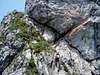
La nostra montagna emerge, a mo' di scoglio roccioso biancheggiante, al termine della lunga dorsale Sud del Monte Bregagno ed è ben visibile a chi percorra la sponda orientale del Lario.
Le rocce calcaree che la compongono vanno ad appoggiarsi, a Nord, alle rocce cristalline del Bregagno presso il valico della Forcoletta.
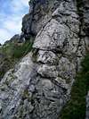
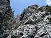
Il versante Sud e Sud-est è formato da una serie di speroni, e torrioni, separati fra loro da fratture e canali più o meno vasti. Il tutto entra a far parte della "linea del Grona", vasta unità tettonica di rocce sedimentarie che, con una serie di archi convessi, parte dal Luganese per giungere al Lago di Como.
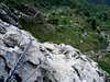
Lo sguardo spazia libero a 360° dalla Pianura Padana ai bacini lacustri del Lario e del Ceresio, si spinge a Nord abbracciando tutte le Alpi, dal Monte Rosa al Vallese, dalla Mesolcina alle Alpi Retiche, per poi scendere di nuovo a mezzogiorno passando per l'imponente piramide del Monte Legnone, l'ombroso e profondo solco della Valsassina e le vette del Grignone e della Grigna.
The steep mountain slopes that rises between Val Sangro and Lago di Como in the north north-west of Menaggio ... The view is magnificent, one of the best of the Alps.
Thus is expressed Silvio Saglio in rare edition dedicated to the foothills Como - Varesine - Bergamo's famous necklace CAI-TCI "Guide of the Mountains of Italy" (1948).
Our mountain is clear, by way 'of whitish rocky cliff at the end of the long south ridge of Mount Bregagno and is clearly visible to those along the eastern shore of the lake.
The limestone rocks that compose go to lean in the North of the crystalline rocks at the point of Bregagno Forcoletta.
The South and South-east side is formed by a series of spurs, and towers, separated by fractures and channels more or less extensive. Everything becomes part of the "line of Grona, large tectonic units of sedimentary rock that with a series of curved arches, leaves from the Lugano area to get to Lake Como.
The view encompasses free at 360 ° from the Po Valley to the lake basins of Lake Como and Lake Lugano, goes north encompassing all of the Alps from Monte Rosa to the Valais, from Mesolcina the Rhaetian Alps, then dropped again at noon through the 'impressive pyramid of Mount Legnone, the shadowy and deep groove of Valsassina and the peaks of Grignone and Grigna.
Getting There

Routes overview
The most amusing route is the Ferrara Centenario CAO at Monte Grona.
 |
 |
 |
 |
 |
 |
 |
 |
 |
 |