
-
 48583 Hits
-
 82.92% Score
-
 17 Votes
|
|
Mountain/Rock |
|---|---|
|
|
38.80290°N / 122.7466°W |
|
|
Sonoma |
|
|
Hiking |
|
|
Spring |
|
|
4700 ft / 1433 m |
|
|
Overview
Cobb Mountain is located about 12 miles Northwest of Mt. Saint Helena, the Napa County highpoint and 35 minutes North and West of Napa Valley by car. Cobb Mountain's West ridge is the Sonoma County high point. Much of Cobb Mtn is in Lake County. The Sonoma cohp is on the west summit and is not the highest part of the mountain.
This is a beautiful hike through the forest to several summits that feature excellent views of ... trees, lots and lots of trees.
The trail is moderatly steep and well shaded. It's an old road that is partially overgrown in spots and has quite a few blown down trees to negotiate. It would appear the road/trail is no longer maintained. Don't let the road part fool you this is a really nice hike.
Getting There
From Calistoga in the Napa Valley take hwy 29 North over Mt Saint Helena to Middletown. Upon entering Middletown take hwy 175 West (left) about 7 miles to the hamlet of Whispering Pines. From 175 turn left onto Maple Shadows Rd. Proceed to Brookside Dr and turn left again. Continue on to Pinewood Way and park in the turnout on right about 100 feet before the gate.Note that there are homes and vacation cabins along these roads and although you may think you hear banjo music, the natives are friendly. I felt right at home!
Directions to Summit
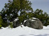
From the trail head, head uphill. Near the start there are a couple of junctions, follow the route that leads up to stay on trail. In about 2 1/2 miles you will come to the East summit. There is a road in front of a transmitting facility. Turn left on this road and stay left at all junctions for the next 1/2 mile or so until you reach the middle summit. This one also has some antennas and equipment on top. Go inside the gate about 100 feet. Head for a equipment shed and look to the left for a large pile of rocks under a tree. This is the summit of Cobb Mountain. It is not however the Sonoma County high point. For further cohp info see below.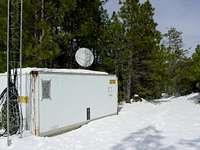
COHP Info
I found the trip reports on cohp.org conlicting, confusing and/or innacurate/outdated. I will do my best to sort this out.Red Tape
This mountain is on private property. The land is leased by a geothermal company. No one seems to mind visitors using the dirt road from Whispering Pines. Previous trip reports indicate that the public has accessed the mountain from this trailhead for many years. Common sense would dictate a weekend vist when workers are not likely to be present. Yes those are no tresspassing signs.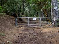
Camping
Bothe-Napa State Park off hwy 29 in the Napa Valley has camping about 40 minutes fromthe trailhead. Look for updates soon.External Links & Resources
For information on this and any other county highpoint check out http://www.cohp.org/. This site has alot of information including trip reports.I recommend Gary Suttle's excellent book "California County Summits". It is the California cohp'ers bible. Without this book my trip to Cobb Mountain and this page would not have been possible.
Chris Doig - Mar 6, 2007 3:43 am - Hasn't voted
PicsIf anyone has good pics of Cobb Mtn, especially from Mt St Helena please add them.
Bubba Suess - Feb 16, 2008 11:10 am - Voted 10/10
Re: PicsI added one a year or so ago. I also attached a cool shot of the mountain from one of the geothermal powerplants. It is kind of a cool perspective. What is with all the low votes on this page?
gregorreis - Dec 31, 2009 12:31 am - Hasn't voted
Roads not driven on in yearsI climbed Cobb Mtn from Whispering Pines on 12/30/2009. The road near the gate seems to get use from locals, however a little ways up the road becomes covered in pine needles and has many fallen trees across it. Most of the roads on this hike haven't been driven on in years, with the exception of the area near the gate and between the two summits with transmitters at the top. I wouldn't worry too much about avoiding work days--any vehicular traffic at the top would be easily avoided by stepping into the bushes.
Dundeel - Mar 30, 2010 7:57 pm - Voted 10/10
Nearby campingBoggs Mountain State Forest has a primitive campground that is free. Only services are an outhouse and a few picnic tables. The access road from 175 is about 1.5 miles north of Whispering Pines.
Noondueler - Oct 6, 2015 11:08 pm - Voted 10/10
Cobb is burnt big timeby the Valley Fire. At least there are views now.