
|
|
Mountain/Rock |
|---|---|
|
|
45.97818°N / 7.28050°E |
|
|
Mountaineering |
|
|
Spring, Summer |
|
|
12192 ft / 3716 m |
|
|
Overview
The Combin de Corbassière is well known summit in the western part of the Pennine Alps. Although, far less popular than its neighbour, the Grand Combin, the summit is climbed frequently in both summer and spring. Most climbers use the Combin de Corbassière as acclimatization climb for the Grand Combin.Unfortunatly the normal route has become increasingly difficult due to global warming. Still, the normal route is a pretty straight forward glacier travel with some scrambling and easy climbing passages near the summit. The summitview is stunning and stretches all the way from the nearby Grand Combin to the Mont Blanc range, Bernese Alps and Monte Rosa Group.

Getting There
Val des BagnesThe Val de Bagnes extends over more than 25 kilometres, from Le Châble to the impressive Mauvoisin dam. The valley is known for the famous ski resort of Verbier. In summer, the valley offers numerous hiking, climbing and mountaineering possibilities. Starting point for the hike to the Panossière hut is the village of Fionnay.
For more information on the Val de Bagnes, and places to stay: www.verbier.ch
 View of Corbassière on the way to the Panossière hut.
Access by car
- Reach the A9/E62 motorway which runs through the Rhone valley, take the exit “Grand-Saint-Bernard, Verbier” and follow the E27 to Sembrancher. Leave the E27 and enter the Val de Bagnes. Head to Le Châble and from there on you can follow signs to Fionnay.
Access by public transport
- Take the train to Martigny and switch to the local train to Le Châble. From there you'll have to take the bus to Fionnay.
Plan your journey on here www.sbb.cb
Starting point for the normal route: Cabane FXB Panossière
The Panossière hut is the most obvious starting point for the normal route on the Combin de Corbassière. The hut can be reached in about 3 to 4 hours from Fionnay.
Contact
Cabane FXB Panossière, 2641 m.
Sylvie et Henri Chastellain
Phone Hut: + 41 27 771 33 22
Phone Valley: + 41 27 565 25 58
Mail: info@cabane-fxb-panossiere.ch
www.cabane-fxb-panossiere.ch
Routes
The Combin de Corbassière is both climbed pretty often in both summer and spring (with ski's). The normal route is straight forward glacier tour which is climbed often in summer and spring. The old route over the glacier des Follâts has become dangerous in summer and is only used for a ski descent in spring.Routes Overview:
- Normal route: start at the Panossière hut and follow the marked path down to the glacier de Corbassière. On the glacier, head southwest and avoid the first icefall on its right side (when going up). The next section is changing often due to the melting glacier, but normally you'll have to climb a gully (scrambling, loose rocks) to reach the upper glacier (SAC map point 3065m). From here on, follow the glacier (first in western direction and than head north) to reach the base of the summit slope. Either go directly from the glacier to the summit (snow, loose rocks) or reach the saddle (SAC Map point 3563m) and then climb the summit slopes. About 4 - 5 hours from the Panossière. Grade: WS/PD.
- South ridge: a pretty popular climb with pleasant climbing on pretty sound rock. The ridge starts at SAC Map point 3402m. About 5 hours from the Panossière. Grade: WS/PD climbing up to UIAA II.
- Traverse: there are several possibilities to traverse the mountain. It also possible to combine a climb with the summit of the Petit Combin. A beautiful traverse is by climbing the north ridge of the Petit Combin and climbing the Corbassière on your descent to the Panossière.
- In winter/spring: the Combin de Corbassière is often climbed on ski's. Unfortunatly, the Petit Combin is marked as a landing zone for heli-skiing. So, don't be surprised when your not alone on your descent.
 Combin de Corbassière seen from the Grand Combin. The red line indicates the normal route on the Combin the Corbassière and the green line is the south ridge.
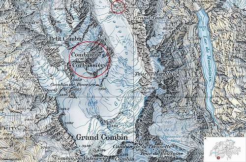 Map of the area around the Combin de Corbassière.
Maps and Guidebooks
Maps: Swiss Alpine Club (SAC) Maps are the most detailed and common maps to use when climbing in Switzerland.- SAC Map: 1346 Chanrion, 1:25000.
- SAC Map: 283 Arolla, 1:50000.
- Online Map: the Swiss Federal Administration offers very detailed and good maps at their website. See map.geo.admin.ch.
Guidebooks: There are several guidebooks you can use to plan your climb on the Combin de Corbassière. Most reliable and detailed are the guidebooks from the Swiss Alpine Club.
- Selected alpine climbs in Valais/Wallis: Hochtouren im Wallis, Hermann Biner, ISBN 10: 3859022040
- Alpine climbs in the western part of the Pennine Alps (between Bernhard pass and Col Collon): Clubführer Walliser Alpen 2 Vom Grossen St. Bernhard zum Col Collon, Maurice Brandt, ISBN 10: 3859021451.
External Links
WSL Institute for Snow and Avalanche Research SLF - Avalance BulletinWeather Forecast - Detailed weather forecast by Meteoschweiz
Railroad information - Railroad schedule
Bus information - Postbus schedule
Val de Bagnes - Tourist Office Val de Bagnes
Jurgen - Mar 8, 2013 8:00 am - Hasn't voted
Re: Maps and guidebooksYou're right. I have changed them, so they should work now.