
|
|
Mountain/Rock |
|---|---|
|
|
46.02420°N / 7.52332°E |
|
|
Mountaineering |
|
|
Spring, Summer, Fall |
|
|
11775 ft / 3589 m |
|
|
Overview
The Dent de Tsalion is captured between two impressive peaks. North lies the impressive Dent de Perroc and south lies the more famous Aiguille de la Tsa. The mountain is located at the end of the Val d'herens valley and risis high above the mountain village of Arolla. The Perroc - Tsa range lies bewteen the big Pennine Alps summits of the Dent Blance (east) and the Mont Blanc de Cheilon (west). The mountain of this range are a bit lower but definitly worth visiting. Especially the ridges are known for their beautiful rock climbs.The mountain can be perfectly combined with de Aiguille de la Tsa or the Pointe de Tsalion. Also the West-ridge is climbed pretty often. The ridge offers a beautiful 600 meters long climb in solid gneis (AD+).
First ascent of the Dent de Tsalion: Gaspoz, Corbet, Echallaz and Townley (13. august 1890).
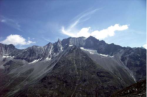 View of the Tsalion, Tsa and Douves Blanche.
Getting There
In general:By Car: From Sion in the Rhône Valley, advance to Val d'Herens, Les Haudères and then to Arolla.
Public Transport: The nearest trainstation is in Sion (about 40km away), from Sion you'll have to take the bus that leads to the village.
To the Bertol Hut:
At the end of the Arolla valley there is a small parking lot. Arolla 2089m - Plans de Bertol - Col de Bertol - Cab de Bertol 3311m : 4 h 30'
See this page for a map of the route.

To the Cab de la Tsa:
Arolla 2089m - Les Places - La Tsa 2607m : 1 h 45'
See this page for a map of the route.

Routes
Normal way from the Bertol Hut:From the Bertol over the ladder back to the Col and then in northeast direction on the saddle between point de Bertol and point 3372 m (cable just below the col). On the other side you see already the summit. But first you'll have to cross a glacier (watch out for crevasses) towards the plateau beneath the summit. Leave the glacier at it's norht end and climb shortly to the summit.
Descent at the same route or, more interesting, descent towards Arolla by traverse the Pointe de Tsalion.
The climb takes about 2-3 hours and doesn't contain any great difficulties under normal conditions (PD/WS).
Normal way from the Cab de la Tsa:
Traverse of the Pointe de Tsalion and the North ridge of the Dent de Tsalion: The Pointe Tsalion is easy to reach under good conditions (with snow much harder to find). There's a marked path wich requires some scrambling to the summit. The traverse to the Dent de Tsalion offers some climbing passages(II).
The climb takes about 3-4 hours (depending on conditions) (PD/WS).
West-ridge of the Dent de Tsalion:
The most beautiful route to the summit is definitly the West ridge. Acording to the Guidebook it is "the most beautiful ridge of it's kind in the area of Arolla".
See the West-ridge route page for more information and pictures.
 West-ridge
Maps and Guidebooks
Maps:* Carte nationale de la Suisse: Nr. 283 Arolla, 1:50000
* Carte nationale de la Suisse: Nr. 1347 Matterhorn, 1:25000
Guidebooks:
* SAC guidebook: Walliser Alpen, Band 3, Nr. 232-6
* SAC guidebook: Hochtouren im Walis, Vom Trient zum Nufenenpaß
External Links
Bertol hut - www.cabanebertol.ch/Tsa hut - www.vs-wallis.de
Digital map - www.mapplus.ch
Weather forecast - www.meteoschweiz.ch
Time schedule train/bus - www.sbb.ch