
-
 72047 Hits
-
 89.39% Score
-
 29 Votes
|
|
Mountain/Rock |
|---|---|
|
|
32.91470°N / 116.8189°W |
|
|
3675 ft / 1120 m |
|
|
Overview
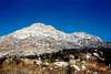
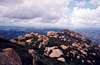
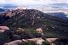
"Often seen, rarely climbed" ....that about sums up El Cajon Mountain, a great climb in eastern San Diego County. Everything ranging from a easy Class 1 hike to a Class 3 scramble to a large 5.11 wall is found here, and is a jewel for climbers. However, the fact that the mountain is nearly completely surrounded by either private property or an Indian Reservation, the trailhead is difficult to find, the valley below is often quite hot, and there is little or no vegetation(fires sweep through Bi-annually), all contribute to this being a rarely-if-ever climbed mountain for locals. The wonderful views from the top ( the Ocean to the West, mountains to the East, Mexico to the South) combined with great exposure, make it worthwhile. Don't underestimate this climb. Though the mountain is only 3675 ft high, there is plenty of elevation gain. The El Cajon Mtn trail has almost 4,000 feet with the ups and downs of the trail. The South Arete climbs 3000 feet in less than 2 miles.
 |  |  |  |  |
Getting There
This part is a little tricky. FOR THE SCRAMBLE AND BIG WALL - From San Diego: Take interstate 8 East to Lake Jennings Road. Turn left and head North. After 3 miles, you'll arrive at El Monte Road. Turn right and head east for 3 more miles. Near the end of the road, there is a sign on your left marked "No Camping, No Fires" . That is the trailhead. There is a few parking spots right there. You know you've gone too far when if you reach the El Capitan Reservoir entrance. FOR THE CLASS 1 hike - Take Interstate 8 East to Highway 67 North. another 6.2 miles north and turn off on Willow. Go east on Willow 9/10 mile and turn left on Wildcat Canyon Road. After 3.4 miles find the small parking area on the right. There is no parking farther up the gravel road. (thanks to mtnrunner for this "getting there" description, as found in the El Cajon Mtn Route section)
 |  |
Red Tape
No Red Tape, but do yourself a favor and stay away from any hostile.., er uh, ..Private Property.
When To Climb
I recommend trying the Class 1 hike in the early spring, after the rainy season has ended. I certainly would not recommend trying the Class 3 scramble during that time, since there is always the possibility of mudslides due to the lack of vegetation. I recommend late Fall/early Winter for the scramble and the big wall.
 |
Camping
No Camping is allowed.
mvbarry1 - Feb 4, 2007 7:03 am - Hasn't voted
Getting There AddendumFOR THE CLASS 1 HIKE: With massive construction in the area, the directions to the parking area need to be revised: At the intersection of Willow Road and Wildcat Canyon Road, take Wildcat Canyon Road 3.3 Miles to Blue Sky Ranch Road and turn LEFT to Oak Oasis Park. Drive straight ahead to the paved parking. On foot, reverse your path and hike back accross Wildcat Canyon Road and continue up the road to the trailhead (approximately 1 mile). The ranger told us that when construction is finished, there will be a tunnel under Wildcat Canyon Road to facilitate safe passage.
pruwe - Apr 12, 2014 2:59 pm - Hasn't voted
WARNING RE CLASS 3Warning: there is no Class 3 TrailHead or trail. You will be trespassing just to get close to the bottom of El Cajon Mountain. Friends and I tried today, April 12, 2014. Very frustrating and had to turn around mid hike. I would not attempt the above directions. Possibly come from the El Cajon Reservoir.