La montagna chiama i suoi figli, ed essi rispondono fedelmente al suo appello…
Osvaldo Cardellina, Diario alpinistico, 1964-65
Page texts: @ OsvaldoCardellina"Osva", passed away on May 2, 2022. Page owners: Christian Cardellina e Osvaldo Cardellina. Any updates from September 12, 2022: Antonio Giani, page administrator, friend and climbing companion.
Testi della pagina: @ OsvaldoCardellina "Osva", scomparso il 2 maggio 2022. Proprietari pagina:Christian Cardellina e Osvaldo Cardellina. Eventuali aggiornamenti dal 12 settembre 2022: Antonio Giani, amministratore della pagina, amico e compagno di salite.
Overview
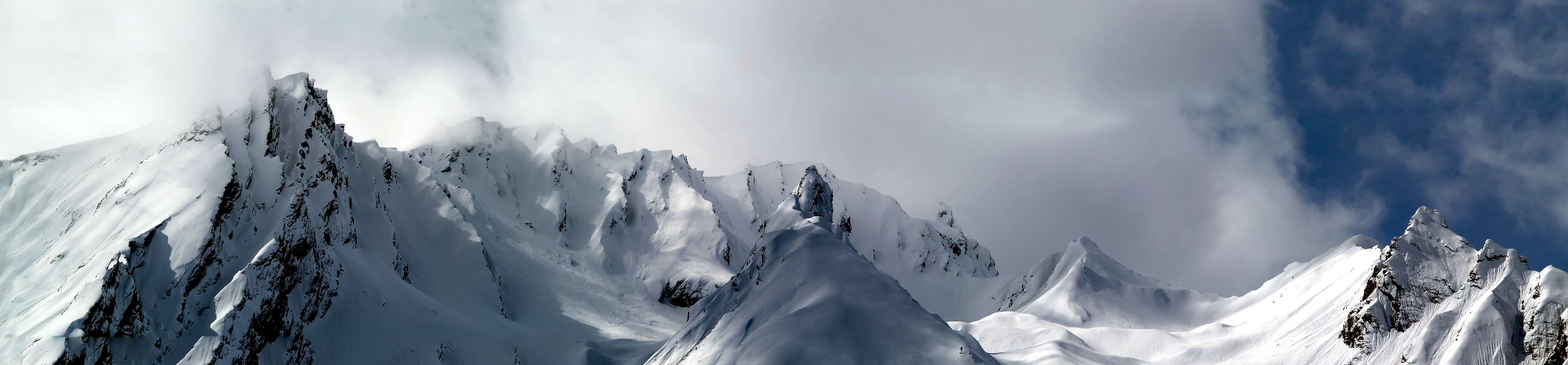
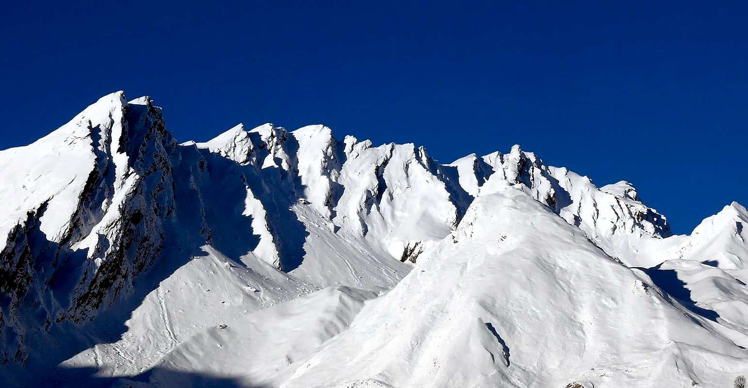
Even this Summit is part of the little Subgroup Grande Rochère (3.326m), constituting the penultimate Vertex to the Northeast before the important Malatrà Hill (2.928m) between the Valley of the same name (West) to the inside of the Val Ferret, and facing the opposite direction to the Combe du Merdeux in the Valley of the Great Saint Bernard. To look stylish and sleek on these two aspects, it provides a third much more "peaceful" and less evident to the South at the end of the long Vallon of Planavalle. Like all Summit of the district has an old, rotten and crumbling rock that does not allow large climbing and that becomes dangerous moving away from its two small ridges to the many faces. For this reason it has few visitors as much in Hiking that in Ski-Mountaineering, much is also true that for the first climbs are very rare and usually carried out almost exclusively by local Mountaineers or by the chamoises Hunters. This fact is evident even more on the Northern Slopes above the Comba Merdeux into the Valley of the Gran San Bernardo, where steep slopes rocky-debris will not advise the climb, which most likely was carried out in very rare occasions exploiting, departing from Fraction Mottes below Bosses more important Village, the small valley between the characteristic Tête des Faces and elegant Pointe d'Entremont before recovering the rather steep coastlines the wall above East-northeast primarily using a scree slope on the left and exiting just South of the Summit. Even ridges, towards the Southeast towards the Crêton du Midi (2.945m) and Northwest, definitely the shortest, to the Aig. of Artanavaz not offer significant potential for being formed by rock climbing very crumbled, often covered with soil and grass layers for which what is described here is recommended exclusively the Normal starting from Vallone of Planavalle and, as the only variant, the second of the crests. Beautiful views of the Mont Blanc more Eastern Mountain Chain, especially in the Northeast by the Grandes Jorasses and to Mont Dolent and on Tour Noir with beautiful shots eye on the nearby South Grand Rochère, presenting her attractive Northern Face above the Vallon of Malatrà, and to the North on the entire Group of Grand Golliaz (3.237m).
Anche questa Cima fà parte del piccolo Sottogruppo della Grande Rochére (3.326 m), costituendo la penultima Cima verso Nordest prima dell'importante Colle di Malatrà (2.928 m) tra il Vallone omonimo (Ovest) all'interno della Val Ferret e quello opposto rivolto alla Combe du Merdeux nella Valle del Gran San Bernardo. Di aspetto elegante e slanciato sopra questi versanti, ne offre un secondo molto più "pacifico" e meno evidente a Mezzogiorno al termine del lungo Vallone di Planavalle. Come tutte le Vette del circondario presenta una roccia vecchia, rotta nonché sgretolata che non consente grandi arrampicate e che diventa pericolosa allontanandosi dalle sue due creste verso le altrettante facce. Per questo motivo è scarsamente frequentata tanto nell'Escursionismo quanto nello Sci-Alpinismo, tanto é vero che anche per il primo le ascensioni che si registrano sono alquanto rare ed in genere effettuate quasi esclusivamente da Alpinisti locali o da Cacciatori di camosci. Questo fatto si evidenzia ancora maggiormente sul Versante Settentrionale sopra la Comba di Merdeux nella Valle del Gran San Bernardo, dove ripidi pendii roccioso-detritici ne sconsigliano del tutto la salita, che molto probabilmente é stata effettuata in rarissime occasioni sfruttando, con partenza dalla Frazione di Mottes sotto il più importante Villaggio di Bosses, il piccolo vallone compreso tra la caratteristica Tête des Faces e l'elegante Pointe d'Entremont per poi risalire i piuttosto ripidi costoloni della soprastante Parete Est-nordest utilizzando principalmente un canalone detritico risalente subito sulla sinistra ed uscendo appena a Meridione della Vetta. Anche entrambe le creste, Sudest verso il Crêton du Midi (2.945 m) e Nordovest, più breve, verso l'Aiguille d'Artanavaz, non offrono grandi possibilità d'arte arrampicatoria essendo formate da roccia molto sgretolata, con terriccio e spesso ricoperta da infidi strati erbosi per la qual cosa qui se ne descrive e consiglia esclusivamente la Via Normale partendo dal Vallone di Planavalle e, come unica variante, la seconda delle due creste o Nordovest. Splendide viste sulla Catena del Monte Bianco, soprattutto nel settore Nordorientale dalle Grandes Jorasses fino al Triolet e Mont Dolent e sul Tour Noir e bei colpi di occhio a Mezzogiorno sulla vicina Grande Rochère, che presenta la sua attraente Parete Nord sopra il Vallone di Malatrà, ed a Settentrione sull'intero Gruppo del Grand Golliaz (3.237 m).
First Ascents
First on the Summit: unknown, probably by Chamoises Hunters.
In winter: unknown.
Southwest Slope (Normal Route): unknown.
Northwest Crest: Osvaldo Cardellina, Sergio Roverso and Nino Trapani; Jun 06th, 1974, departing from Aiguille d'Artanavaz and crossing in ascent to Quotas 3.028 meters, 3.062 meters or Grand Crêton Northwestern Summit and Southeastern Top 3.071 meters, with descent along the Southern Slope to Planavalle.
East-northeast Ridge (from little saddle with Pointe d'Entremont or Quota 2.650 meters): Osvaldo Cardellina, lone, Aug 16th, 2011; in ascent from Potz-Artusi in Combe du Merdeux to SE Top, with traverse to Grand Crêton NO Summit 3.062 meters and Aiguille d'Artanavaz; descent on Col Malatrà by Northern Crest.
Northern Slopes: unknown or Osvaldo Cardellina, lone, Nov 02th, 2011 through the Northern Face of Northwestern Summit also Quota 3.062 meters.
East-southeast Ridge Ovaldo Cardellina, lone; Aug 17th, 1978, in descent after traverse from Aiguille d'Artanavaz.
Topographically on Crest
Small hatch Topographical
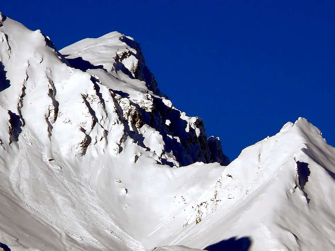
From the Great Rochère (3.326m), the highest elevation of this small subgroup, down to the Northeast a long ridge, which would separate the Valley of Planaval East to those overlying the Val Ferret, as the Hill of Bonalé or Bonalex (2.925m) and aiguille of the same name (3.142m), the small Aiguilles de Malatrà (3.142m) and Artanavaz (3.071m) over Malatrà Hill (2.928m). Moreover the ridge continues, the same direction until you reach the Grand Golliaz (3.237m) and flexing more and more to the East, reaching the Great St Bernard Pass (2.469m). We are at the beginning of the Pennine Alps, with the majestic Chain of Mont Blanc, and at the end of the Graian as highlights very well the type of rock. There flaked and formed by mica schist transformed, here composed of solid granite. Important knot orographic and topographical, is mistakenly placed further East from the CNS (National Charter Switzerland) that confuses with the less important Altitude 3.028 meters. From its Summit descend three crests: the first or Northern a very short with above with Malatrà, while the other two, in the shape of the sides of an isosceles triangle, down "quieter" respectively to the Southwest towards a notch with the Aiguille de Malatrà and Southeast to the Grand Crêton, Top with identical exact elevation (3.071m). The two sides are courtyard with rock walls somewhat route facing North-northeast over the a small Vallon secondary of the Combe du Merdeux, while to the South-southwest above the Vallon Palanavalle down a slope enough steep composed almost exclusively of fine debris, small rotten rocks and grassy slopes. Yet over the partition it reaches Creton du Midi (2.945m), the Costa Serena (2.785m, 2.744m) to finally "get lost" over the Col Serena or Serena's Window (2.547m), an important transit point between Vallon Planaval in South and Combe Merdeux to the North.
Piccolo tratteggio Topografico
Dalla Grande Rochère (3.326 m), massima elevazione di questo piccolo sottogruppo, scende verso Nordest una lunga cresta che, atta a separare il vallone di Planaval ad Oriente da quelli soprastanti la Val Ferret, forma il Colle di Bonalé o Bonalex (2.925 m) e l'omonima aiguille (3.142 m), la piccola Aiguille de Malatrà e quella d'Artanavaz sopra il Colle di Malatrà (2.928 m). Oltre la cresta spartiacque prosegue, stessa direzione, fino ad arrivare al Grand Golliaz e, flettendo sempre più ad Oriente, raggiungere il Colle del Gran San Bernardo (2.469 m). Siamo all'inizio delle Alpi Pennine ed al termine, con la maestosa Catena del Monte Bianco, delle Graie, come evidenzia molto bene la tipologia della roccia. Là sfaldata e formata da micascisti trasformati, qua composta da solido granito. L'Aiguille d'Artanavaz risulta quale importante nodo orografico e topografico, ma viene collocata erroneamente più ad Est dalla CNS (Carta Nazionale Svizzera) confondendola con la Quota 3.028 metri. Dalla Sommità scendono tre creste: una molto breve con piccoli risalti sopra il col Malatrà, mentre le altre due, a forma di lati di triangolo isoscele, scendono "più tranquille" rispettivamente a Sudovest verso un intaglio con l'Aiguille de Malatrà (3.142 m) ed a Sudest verso il Grand Crêton, Cima subito affianco e con identica esatta altezza (3.071 m). I due versanti di quest'ultima son rivolti con corte pareti di roccia alquanto rotta a Nord-nordest sopra un valloncello laterale rispetto alla Comba du Merdeux ed a Sud-sudovest sopra il Vallone di Planavalle, dove scende un versante meno ripido formato quasi esclusivamente da abbastanza ripidi pendii erbosi, roccette e fine detrito. Oltre ancora il divisorio raggiunge il Creton du Midi, la Costa di Serena per infine "perdersi" sopra il Colle di Serena (2.547 m), importante punto di transito tra il Vallone di Planaval a Sud e la Comba di Merdeux a Settentrione.
Getting There
Western and Northwestern Getting There BY CAR:
From TORINO, MILANO, etc: Motorway A5. Exit at IVREA or Quincinetto (PIEDMONT).
From IVREA Town: in West towards Pont Saint Martin, Donnas, Bard, Champdepraz, Pontey, Fénis, Saint Marcel, Grand Brissogne, Pollein, Charvensod, Gressan, Jovençan, Aymavilles, to Villeneuve, Arvier, Avise, Morgex and to Pré Saint Didier, Courmayeur Municipalities (Western side).
From Courmayeur Resort: in East to Morgex, La Salle, Saint Pierre, Sarre, Aosta Municipalities.Southern Side in Planavalle Torrent & Baltea Stream: From La Salle Common towards Planavalle Vallon From La Salle (1.001m), with Regional Road, towards Challancin (1.610m), Cheverel, Morges (1.829m), Planaval Hamlets (1.750m); from this, through farms dirt road in North-northeast, passing Maison Blanche Pasture, towards the Rantin (2.333m) and Bonalé (2.340m) Alpages, in Upper Planaval small Valley. Northwestern Side in Rio Artanavaz Torrent: From Aosta Town to Merdeux Basin From Saint-Oyen(1.377m), with previous road to Mottes, continue West-northwest to Devies Village (1.723m) at the beginning of Merdeux Comba; from this with paths through Merdeux Dèsott (1.919m), Cotes (1.930m), Manda (1.973m), Tsa de Merdeux (2.285m) Pastures to Malatrà Hill (2.928m). From Saint Rhémy en Bosses Commune(1.619m), through Municipal Road, on Merdeux Comba to Tsa de Merdeux (2.285m) and Malatrà Hill (2.928m).
From FRANCE: through the Mont Blanc Tunnel to Entrèves-crossroads to Vény/Ferret Valleys - Mountain Guides of Courmayeur - La Saxe Rock Gym - Courmayeur. By Little Saint Bernard Pass, closed since November until half May to La Thuile Valley - Pré Saint Didier - Courmayeur. It is not necessary to take Motorway A5: you can drive on SS.26, in the direction of AOSTA - IVREA - TURIN.
BY PLANE:
Aeroporto "Corrado Gex" Saint Christophe (Aosta).
Standard Route
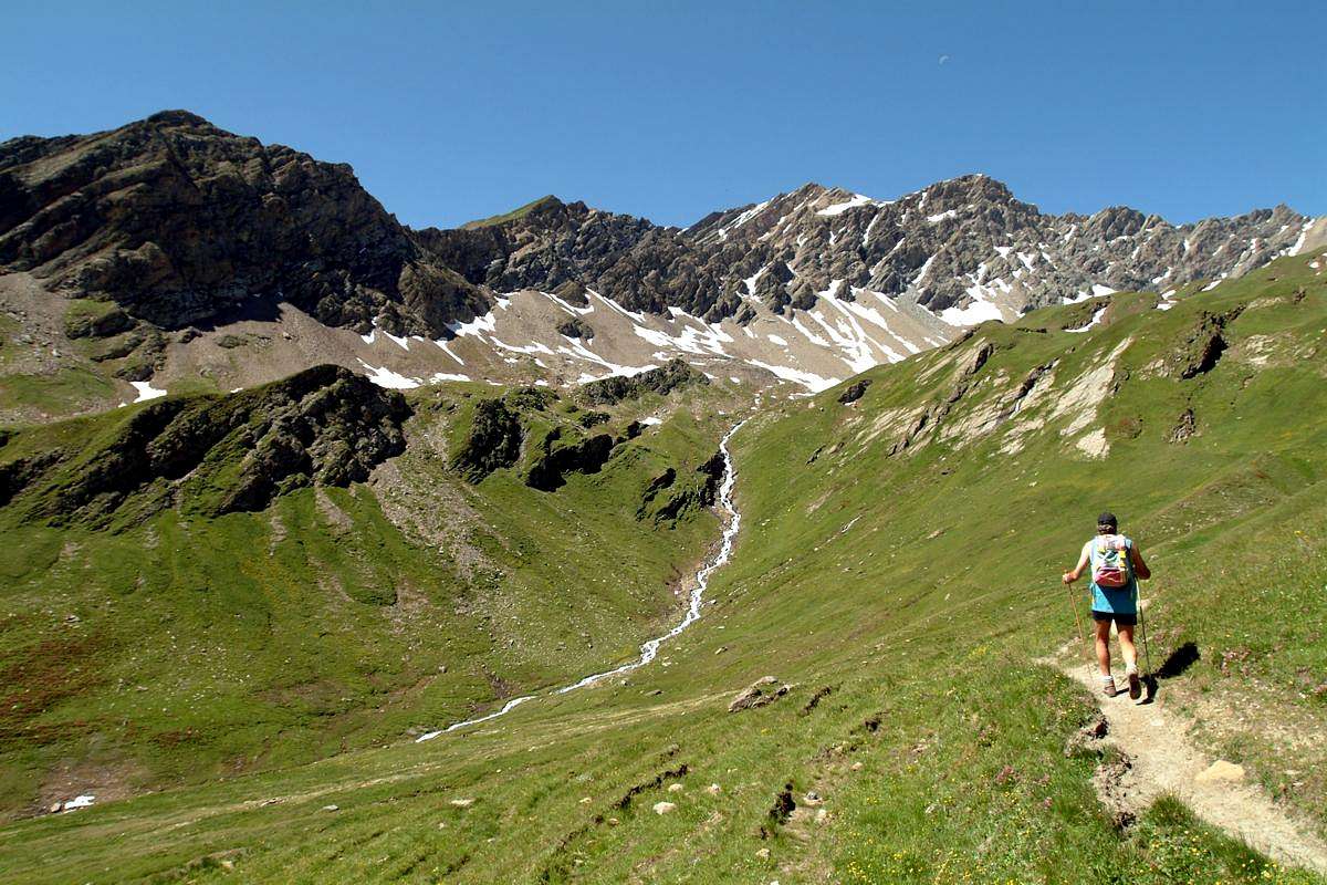
Approach and route from Planavalle: from La Salle Common reach the Planavalle Valley. By tiny Hamlet (1.750m), below the Bec de l'Aouillé (2.535m), proceed using the dirt road, concomitant with the trails n° 3A/6/7, and through a long diagonal enough steep to reach before the suspended Alp Rantin (2.338m; immediately before start in South-southeast the deviation with trail n° 3A towards the Tramail des Ors and Fetita Hill), where the valley splits sending a branch to the Northeast towards the Serena Hill with path n° 6, and after that of Bonalé or Bonalex (2.340m; source; 1h'45/2h'00) located immediately to the West of the long crest called Côte de Serena (2.785m, 2.744m), on South Ridge of Crêton du Midi), here this ends as path n° 7. Leaving Northwest the way to the Great Rochère, continue further North through a small path not numbered nor reported running out towards the 2.415 meters at the end of the Southern "Crestone" of Crêton du Midi (3.071m). Ending the path next to the stream at the bottom vallon, progressively it flexes just right following a steep grassy promontory placed between two secondary torrents reaching the altitude of 2.740 meters. Cross the undulating vallon above amongst grassy and debris fields with sparce blocks, leaving the left (West) Aiguille de Bonalé, to reach the Lac de Bonalex (2.782m), immediately below that of Malatrà (3.142 m; E/F; 1h'15/1h'30; in total 3h'00/3h'30). From here, leaving left (North-northwest) the similar and parallel route towards the Aiguille d'Artanavaz (3.071m), go instead directly to the Northeast reaching the base of the steep Southwestern Slope at an altitude of 2.845 meters about. Take the same with some small rocks and debris, making sure on the many traits covered with very dangerous grass "olline" before reaching enough easily the Summit (EE/F; 1h'30/1h'45; in all
4h'30/5h'00).
Variant through NW Ridge: from the lake easily climb, holding slightly more to the right or North-northeast, up to the depression between the Aiguille Artanavaz and Grand Crêton (2.950 meters around); reached this turn right and go up through the Northwest Ridge, with pretty easy but certainly safer route: bypassed the altitude (3.062 meters, in a short time you get to the Vertex (passages of I°/I°+; exposure facing North or San Bernard Valley; 4h'45/5h'15). This mountain, like the neighbors Aiguille d'Artanavaz (3.071m) to the West, Crêton du Midi (2.945m) in East and the Côte de Serena (2.785m) in southeast, are rarely paths; route are more delicate that difficult, because of the very bad rock quality and the presence of grassy "ollina" layers above the same. Therefore greater emphasis on Hunters than to Mountaineers and especially for Hikers.
Avvicinamento e Via dal Villaggio di Planavalle: dal Villaggetto di Planaval (1.750, m), sottostante il Bec de l'Aouillé (2.535 m), procedere utilizzando il lungo diagonale verso Settentrione della strada poderale sospesa sopra all'omonimo vallone, fino a raggiungere dapprima l'Alpe Rantin (2.338 m), dove il medesimo si sdoppia inviando un ramo verso Nordest al Col Serena (2.547 m; verso il Gran San Bernardo), e poi, doppiato a sinistra il costolone dalla Quota 2.710 metri, quella di Bonalé (2.340 m; sorgente; 1h'45/2h'00) posta subito ad Occidente della lunga cresta chiamata Côte de Serena (2.785 m), ove questa ha termine. Lasciando a Nordovest la via verso la Grande Rochère, proseguire più a Settentrione tramite un sentierino non numerato e neppure segnalato che si esaurisce verso i 2.415 metri circa al termine del Crestone Meridionale del Crêton du Midi (3.071 m). Terminando il percorso a fianco del torrente lungo il suo lato idrografico di destra (Ovest) sul fondo vallone, progressivamente si flette appena sulla destra seguendo un ripido promontorio prativo posto tra due torrentelli secondari raggiungendo l'altitudine di 2.740 metri. Attraversare l'ondulata conca soprastante in genere con residui nevati oppure dossi prativi, lasciando sulla sinistra (Ovest) l'Aiguille de Bonalé, per pervenire al Lac de Bonalex (2.782 m), subito al di sotto di quella di Malatrà ad Ovest e del Grand Crêton ad Est (3.142 m, 3.071 m; E/F; 1h'15/1h'30; in totale 3h'00/3h'30). Da qui, abbandonando a sinistra (Nord-nordovest) l'itinerario verso l'Aiguille d'Artanavaz, proseguire invece direttamente verso Nordest raggiungendo la base del ripido versante Sudovest a quota 2.845 metri circa. Percorrere il medesimo con qualche roccetta e detriti, facendo attenzione ai numerosi tratti ricoperti da erba "ollina", raggiungendo abbastanza facilmente la Cima (EE/F; 1h'30/1h'45; complessivamente 4h'30/5h'00).
Variante per la Cresta NO: dal lago salire facilmente, tenendosi leggermente più verso la destra, alla depressione tra l'Aiguille di Artanavaz ed il Grand Crêton (2.950 metri circa); raggiunta questa piegare a destra e salire tramite la Cresta Nordovest con percorso abbastanza facile ma certamente più sicuro. Scavalcata la quota (3.062 metri, in breve tempo si arriva alla Vetta (passaggi di I°/I°+; esposto a Nord; 4h'45/5h'15). Questa montagna, come i viciniori Aiguille d'Artanavaz (3.071 m) ad Ovest, Crêton du Midi (2.945 m) ad Est e la Côte de Serena (2.785 m) a Sudest, sono assai raramente percorsi; infatti sono itinerari più delicati che difficili, a causa della cattiva qualità della roccia e della presenza di strati erbosi con erba "ollina" sopra la medesima. Quindi son percorsi maggiormente adatti per Cacciatori che non per Alpinisti e tantomeno per Escursionisti.
Difficulty & Equipment
This route can be considered E/F or EE/F+ (Experts Hikers) in winter (even by snowshoes or Ski).
L'itinerario è da classificare in E/F oppure EE/F+ (Escursionisti Esperti) in inverno (anche tramite Racchette da neve od in Scialpinismo).
Hiking gear, in winter as for Ski-Mountaineering or with Snowshoes.
Da Escursionismo, in inverno da Scialpinismo o con Racchette da neve.
Mountain Condition
Meteo: you can find all the needed informations at the official site of the Valle d'Aosta Region: Valle d'Aosta Meteo
Books and Maps
"Guida delle Alpi Occidentali" di Giovanni Bobba e Luigi Vaccarone C.A.I. Sezione di Torino Volume II° (parte II) 25-05-1896.
"Guida dei Monti d'Italia-Alpi Pennine" (Vol. I°) di Gino Buscaini-Club Alpino Italiano/Turing Club Italiano, Luglio 1971.
Kompass "Monte Bianco Valle d'Aosta Sentieri e Rifugi" Carta turistica 1:50.000.
Ediz. Bottega D'Arte Alpina Coumayeur "Carta Turistica della Valle d'Aosta" di Alessio Nebbia 1:100.000.
Parents refers to a larger category under which an object falls. For example, theAconcagua mountain page has the 'Aconcagua Group' and the 'Seven Summits' asparents and is a parent itself to many routes, photos, and Trip Reports.


 3437 Hits
 81.18% Score
 13 Votes