La montagna chiama i suoi figli, ed essi rispondono fedelmente al suo appello…
Osvaldo Cardellina, Diario alpinistico, 1964-65
Page texts: @ OsvaldoCardellina"Osva", passed away on May 2, 2022. Page owners: Christian Cardellina e Osvaldo Cardellina. Any updates from September 12, 2022: Antonio Giani, page administrator, friend and climbing companion.
Testi della pagina: @ OsvaldoCardellina "Osva", scomparso il 2 maggio 2022. Proprietari pagina:Christian Cardellina e Osvaldo Cardellina. Eventuali aggiornamenti dal 12 settembre 2022: Antonio Giani, amministratore della pagina, amico e compagno di salite.
Great Country Overview Gran Paese
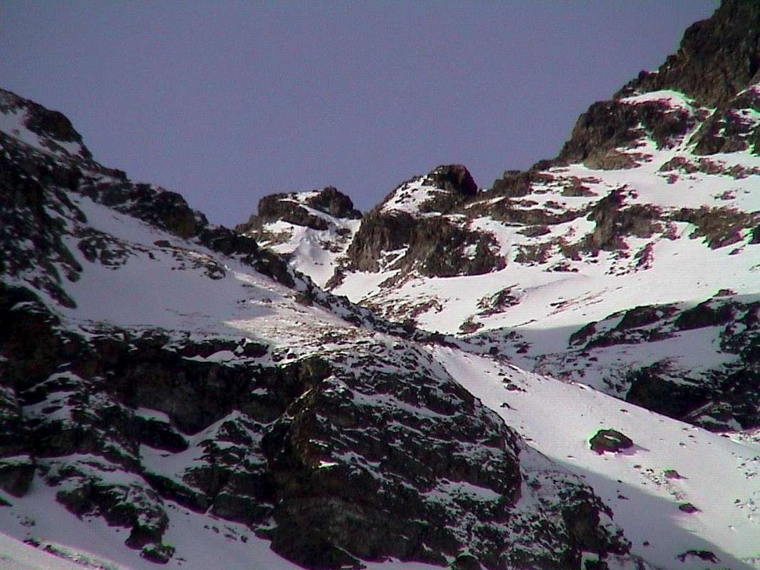
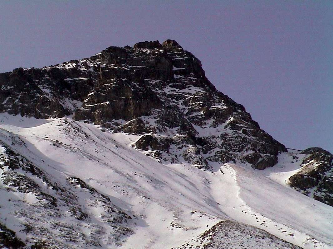
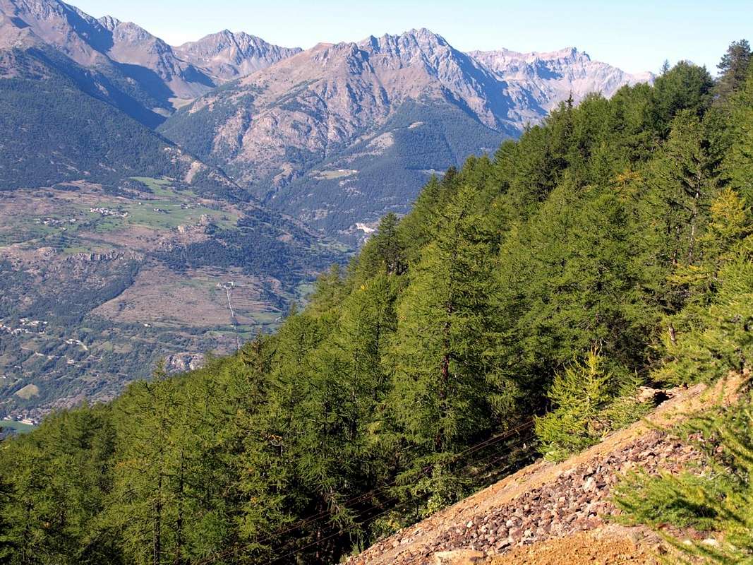
This small Summit is located amidst Becca d'Aveuille or Aveille (2.623m) Mount Faroma (3.073m) between the Comba Dèche and the Valley of St. Barthélemy. Amongst these two valleys is located the Col de Lechy or Léché (2.585/8m, the not much known and less popular passage even in the past. Arranged on the North/South axis with respect to the hill also has esclusively two ridges with a third less in evidence in the East to the Vallons Brevaz/Champanement. Even the respective East and West sides do not offer interesting climbing routes but boring slopes and dangerous to go both in winter as in summer due to the presence of grassy layers. The first down with a great stony ground above the Alps Clavel La Seyvaz or Seiva, while the second is divided by a third crest, just mentioned, which descends separating Collet, Fontin, Pleoles Dèsott Pastures. Factors these, that such to determine the path of the ridges as the unique recommended, while for the Ski-Mountaineering part should use the Eastern Slope or St. Barthélemy. In return, beautiful diametrically opposed views towards Graians towards the South above the Dora Baltea and almost to the entire Pennine Chain in the North.
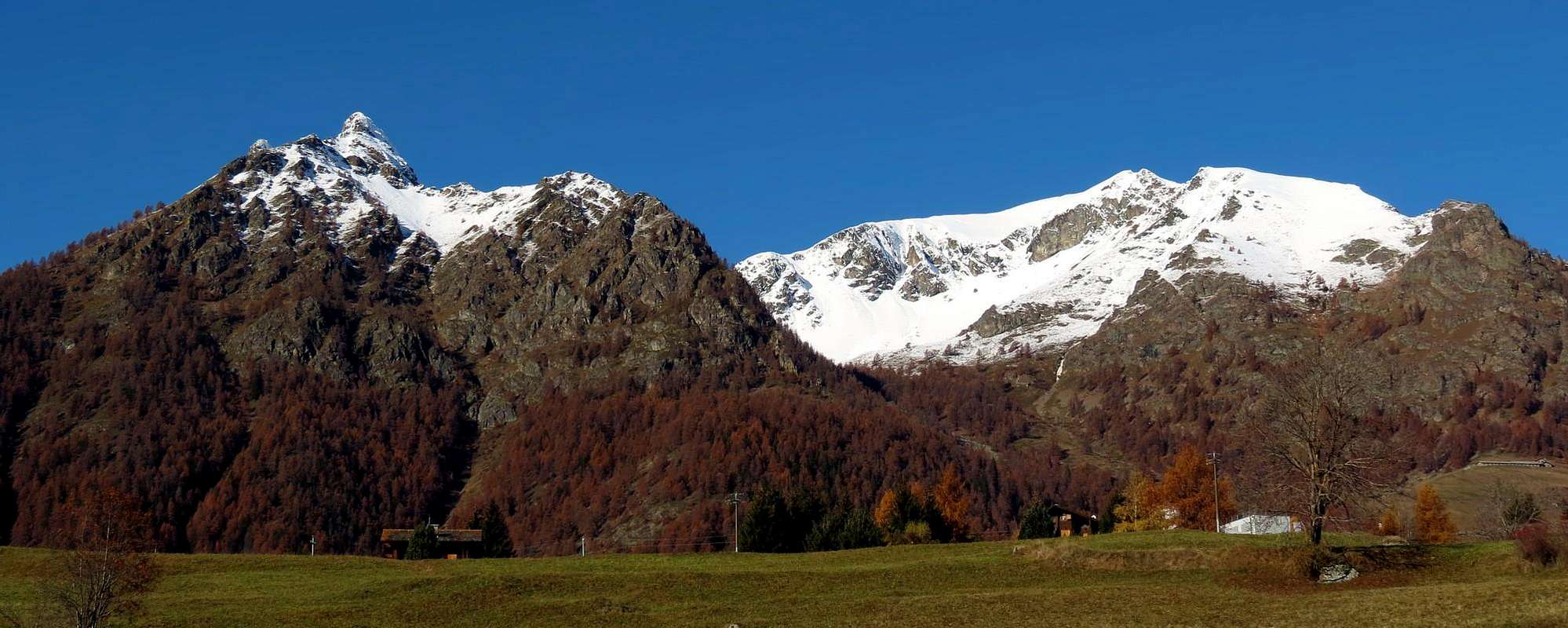
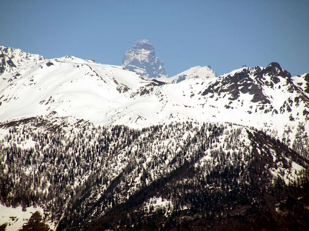
Grand Pays Eastern Slope above Becca d'Aveuille & St. Barthélemy, by Antonio 2011
Questa piccola Sommità é collocata tra la Becca Becca d'Aveuille od Aveille (2.623 m) e Monte Faroma (3.073 m) tra Comba Dèche e Valle di St. Barthélemy. Tra queste due vallate é collocato il Col de Lechy or Léché (2.585/8m, non molto conosciuto e scarsamente frequentato anche in passato. Disposto sull'asse Nord/Sud rispetto al colle, presenta esclusivamente queste due creste principali con una terza meno in evidenza ad Oriente verso il Vallone di Brevaz/Champanement. Anche i rispettivi versanti Est ed Ovest non propongono vie di roccia interessanti ma pendii noiosi e pericolosi da percorrere sia in inverno che in estate per la presenza di strati erbosi. Il primo scende con una pietraia sopra le Alpi di Clavel e La Seyvaz, mentre il secondo viene diviso da una terza cresta, appena accennata, che scende separando le Alpi di Collet, Fontin e Pleoles Dèsott. Fattori questi, tali da determinare il percorso in cresta come unico consigliabile, mentre per la parte Sci-Alpinistica convien sfruttare il Versante Orientale ovvero di St. Barthélemy.Compensano belle vedute diametralmente opposte verso le Graie a Sud sopra il corso della Dora Baltea ed a Settentrione su quasi tutta la Catena delle Pennine.
First Ascents
First on the Summit: unknown.
In winter: unknown.
Getting There
BY CAR:
From TORINO, MILANO, etc: Motorway A5. Exit at IVREA or Quincinetto (PIEDMONT).
From IVREA Town: in West to Pont Saint Martin, Donnas, Bard, Verrès, St. Vincent, Châtillon, Nus, Quart, St. Christophe, Aosta and Roisan Municipalities. From Courmayeur Resort: in East to Morgex, La Salle, Saint Pierre, Sarre, Aosta, Roisan and Saint Chistophe Municipalities.
From Aosta Town towards Quart and Nus Municipalities1) - By Quart-Villair to Epilaz, Argnod Villages or from SS.26 nearby La Plantaz (540m), with Regional and Municipal Roads, towards Chétoz, Vignil, Fornail, Ville sur Nus-Planeville, Buignod, Porsan Villages to Trois Villes-Avisod Village (1.398m). From this towards La Seyvaz, Valchourda Alps (2.206m), in Comba Dèche. 2) - From Quart to Fonteil (1.423m) with previous route; this through dirt road, towards La Seyvaz (2.184m), Valchourda Alps (2.392m), in Comba Dèche.
From Nus-La Plantaz in State Road to Ville sur Nus-Planeville (1.113m); from this, towards Buignod, Avion (1.312m) Villages. Also from Porsan through Trois Villes (1.398m), Avion, fork (1.250m) to Effraz Village (1.487m), with Municipal Roads. From this to Ronc (1.737m), Machaussy Alps, in Effraz Comba.
From FRANCE: through the Mont Blanc Tunnel to Entrèves-crossroads to Vény/Ferret Valleys - Mountain Guides of Courmayeur - La Saxe Rock Gym - Courmayeur. By Little Saint Bernard Pass, closed since November until half May to La Thuile Valley - Pré Saint Didier - Courmayeur. It is not necessary to take Motorway A5: you can drive on SS.26, in the direction of AOSTA - IVREA - TURIN.
BY PLANE:
Aeroporto "Corrado Gex" Saint Christophe (Aosta).
Route
A) - Approach from Fonteil Village (1.423m): with the same route towards St. Barthélemy Hill up to the Valchourda upper Alpage (2.392m; E/F; 3h'15/3h'30). So, abandoning the path to the Northwest towards the hill, completely change direction to Southeast and with the diagonal path n° 4/105 into a very small valley reach the Col de Lechy or Léché (2.585/8m; E/F; 0h'40). From this last continue to the South through small path and traces n° 4 climbing on the more than easy North Crest shaped of a debris-grassy rounded hump to the Summit (E/F; 0h'30 from hill; 4h'00/4h'30 in total). This excursion, as on the other side of St. Barthélemy, is very popular in the Ski-Mountaineering.
A) - Avvicinamento dal Villaggio di Fonteil (1.423 m): con l'identica via al Colle di St. Barthélemy insino all'Alpe di Valchourda (2.392 m; E/F; 3h'15/3h'30). Quindi, abbandonando a Nordovest il sentiero al colle, cambiare completamente direzione a Sudest e col sentiero n° 4/105 in diagonale dentro un valloncello raggiungere il Col de Lechy o Léché (2.585/8 m; E/F; 0h'40). Da quest'ultimo continuare a Sud col sentierino n° 4 e tracce percorrendo la più che facile Cresta Settentrionale a forma di dosso detritico-erboso fino alla Cima (E/F; 0h'30 dal colle; 4h'00/4h'30 in totale). Quest'escursione, come sul versante opposto di St. Barthélemy, é molto frequentata nello Sci-Alpinismo.
B) - Approach from Clémensod or Effraz Villages (Ski-Mountaineering Route): from Lignan Hamlet quickly reach with the Regional Road to the Northwest the next Village Clémensod (1.655m), located at the entrance of the Vallon of Breva or Brevaz. From this point, accessible by private dirt road even from the Village of Effraz(1.487m) on the opposite side, go up with the trail n° 105 until the second junction immediately below the Pleoles Dèsott Pastures (1.789m). By this fork there are two rising possibilities:
1) - continue on to the Southwest with the path n° 9 reaching the Fontin Alps and Collet (2.003m, 2.251m) and Col Collet (2.500m), located between the Becca d'Aveille and Grand Pays; from this, turning right (North), rising up the easy Crest South (BSA; 5h'00/5h'30).
2) - From the junction continue towards Northwest through the path n° 8/105 coming from Lèchy Alp (2.299m); by this, flexing more to the West, to reach the Col de Léchy (2.585m), located between Grand Pays and Monte Faroma. With the simply North Crest to the Summit (BSA; 5h'30/6h'00). Remark
3) - In both cases it is possible to make the crossing to the West down to Comba Dèche before returning through the small Villages Effraz, Valservière(1.502m) and Arlod(1.554m) with a long entire detour around the Becca d'Aveille (OSA or Excellent-Mountaineers Skiers; 8h'30/9h'00).
B) - Avvicinamento dai Villaggi di Clémensod o di Effraz (Via Sci-Alpinistica): dalla Frazione di Lignan raggiungere in breve tempo con la Strada Regionale a Nordovest il successivo Villaggio di Clémensod (1.655 m), posto all'ingresso del Vallone di Breva o Brevaz. Da questo punto, raggiungibile tramite strada poderale anche partendo dal Villaggio di Effraz(1.487 m) sul versante opposto), salire con il sentiero n° 105 fino al secondo bivio subito appresso l'Alpe di Pleoles Dèsott (1.789 m). Da quest punto esistono due possibilità di salita:
1)- continuare verso Sudovest con il sentiero n° 9 raggiungendo le Alpi di Fontin e Collet (2.003 m, 2.251 m) ed il Col Collet (2.500 m), posto tra Becca d'Aveille e Grand Pays; da questo, volgendo a destra (Nord), risalire lungo la facile Cresta Meridionale (BSA; 5h'00/5h'30).
2)- Dal bivio proseguire verso Nordovest per mezzo del sentiero n° 8/105 arrivando all'Alpe Lèchy (2.299 m); indi, flettendo maggiormente ad Ovest, raggiungere il Col de Léchy (2.585 m), posto tra Grand Pays e Monte Faroma. Con la semplice Cresta Settentrionale in Vetta (BSA; 5h'30/6h'00). Nota
3) - In entrambi i casi é possibile anche effettuare la traversata ad Ovest scendendo in Comba Dèche onde rientrare passando tramite i Villaggi d'Effraz, Valservière(1.502 m) ed Arlod(1.554 m) con un lungo giro attorno alla Becca d'Aveille (OSA; 8h'30/9h'00).
Difficulties & Equipment
This route can be considered E/F or EE/F+ (Experts Hikers) through the S-SE Crest. In winter by Ski-Mountaineering or Snowshoeing EE/BSA (Good Skiers-Montaineers).
L'itinerario è classificato E/F oppure EE/F+ (Escursionisti Esperti) tramite la Cresta S-SE. In inverno in Sci-Alpinismo od in Racchette da neve EE/BSA Buoni Sciatori Alpinisti).
Hiking gear or in winter with ski and snowshoes (better with ARVA).
Da Escursionismo oppure in inverno tramite Sci oppure in Racchette da neve (meglio con ARVA).
Times
Calculating an average between the 400/50 meters per hour or in winter by Ski or Snowshoe of 250/300). Time basis: 4h'00/4h'30 from Fonteil (Quart) or Lignan and Clémensod (St. Barthélemy Valley) Villages 4h'30/5h'00.
Calcolare una media tra i 400/50 metri all'ora oppure in inverno tramite Sci o in Racchette da neve di circa 250/300). Tempo base: 4h'00/4h'30 dai Villaggi di Fonteil (Quart) oppure da Lignan e Clémensod (St. Barthélemy) 4h'30/5h'00.
Books and Maps
BOOKS:
"Guida della Valpelline" de l'Abbè Joseph-Marie Henry - Societè Editrice Valdotaine 1925 II Edition e Collana Reprint Musumeci (1986).
"Guida dei Monti d'Italia - Alpi Pennine (Vol. 2)" di Gino Buscaini - Club Alpino Italiano/Turing Club Italiano, Luglio 1970 (In Italian).
"80 itinerari di Escursionismo Alpinismo e Sci Alpinismo in Valle d'Aosta", di Osvaldo Cardellina, Ed. Musumeci, Giugno 1977 (in Italian); seconda Ed. Luglio 1981; terza Ed. Luglio 1984; (in French), prima Ed. Febbraio 1978; seconda Ed. Marzo 1980.
Parents refers to a larger category under which an object falls. For example, theAconcagua mountain page has the 'Aconcagua Group' and the 'Seven Summits' asparents and is a parent itself to many routes, photos, and Trip Reports.


 1861 Hits
 80.49% Score
 12 Votes