
-
 50280 Hits
-
 90.48% Score
-
 32 Votes
|
|
Mountain/Rock |
|---|---|
|
|
36.23250°N / 115.645°W |
|
|
Clark |
|
|
Hiking, Mountaineering |
|
|
Spring, Summer, Fall, Winter |
|
|
11056 ft / 3370 m |
|
|
Overview
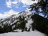
Griffith Peak is the 3rd highest mountain in southern Nevada. Although it stands out as one of the major peaks of the Spring Mountains and is readily visible from most parts of Las Vegas, it appears to many as somewhat of a minor bump at the southern end of the long north-south ridge that heads up to Mt. Charleston. Regardless, Griffith Peak is a mountain of its own and a worthy objective.In the range, Griffith Peak is likely only second to Mt. Charleston in the number of hikers it sees on its summit. Although a nice destination for its own sake, the mountain also makes a fine alternative dayhike for those not willing or able to tackle the more committing Mt. Charleston effort. And for those with the extra energy and will, Mt. Charleston and Griffith Peak can easily be tagged together either as part of a loop hike (see the North Loop - South Loop sections on the Mt. Charleston page) or just doing it the South Loop-way.
There are two primary routes to the summit: The South Loop Trail and the Harris Springs Trail. Although I have traveled the Harris Springs Trail and found it enjoyable, the South Loop Trail is far preferable and will be discussed in further detail in the route section.
*You might also check out my fledgling outdoor site (www.backcountry-explorer.com), which provides access to trip reports, beta, photos and other stuff covering hiking, scrambling, climbing and canyoneering around Las Vegas. My new hiking and scrambling guidebook, Rambles & Scrambles: The Definitive Guide to Peakbagging Around Las Vegas, is now available.
 |  |

Getting There
From Las Vegas, take highway 95 (north) to the Kyle Canyon turn-off (highway 157). Turn left (northwest) and follow the road for maybe 10-12 miles into the small community of Mt. Charleston. En route, you will pass through the desert scrub lands of the lower part of Kyle Canyon, into the Joshua tree lands of the middle section (be sure to check out the La Madre Mountain scar to the south), then into the pinon/juniper woodlands of the upper middle portion, and ultimately to the ponderosa forests of the upper canyon. Once into the community, you will pass the Kyle Canyon Ranger Station on the left, some homes, a school, a library, and then further, a fire station on the right. Just past the fire station, where the main road starts to bend to the left, a smaller road branches off straight ahead. Forget about the smaller road and follow the main road to the left. A mile or so ahead is the Cathedral Rock parking area (on the right), some cabins on the left, and a little bit further ahead on the left, a lodge. You can park at the Cathedral Rock parking area, or if the road's open and you don't mind paying a few bucks to park, continue on a side road immediately past the Cathedral Rock parking area as it goes up and to the right to a higher parking area. Whether on foot or in your vehicle, you want to head up into the higher parking area - it is here that you will find the South Loop trailhead.Red Tape
No permits, fees or passes are required to climb the mountain.The mountain is open and accessible year round.
Much of the mountain is comprised of wilderness, so please, respect the land.
When To Climb
Although generally climbed in the summer and fall months, Griffith Peak can be climbed any time of year. During snow months, snowshoes and/or crampons and ice axe are generally needed. Avalanche awareness is also a crucial part of the Griffith Peak winter experience, as a portion of the South Loop trail route travels across avalanche prone slopes in the area of Echo Cliffs.DesertAdventures also adds:
"Splitboarding, Snowboarding or Skiing is AWESOME
Just a lil' inside info this chute is a great place to ride but exercise caution because it is in a direct avalanche path and holds a ton of snow on a steep angle."
Camping
Backcountry camping is allowed without a permit and without cost. Obviously, practice minimum impact camping and travel.Fires are not allowed, and the collection of bristlecone wood is prohibited.
There are many developed campgrounds in the Mt. Charleston area. For more information on campgrounds, contact the USFS number below.
Mountain Conditions
I am not aware of any webcams in the Mt. Charleston area, but if you want an idea of what current conditions are like, try contacting the USFS at 702-515-5400.As is typical with the higher mountains, expect frequent afternoon thunderstorms in the summer. Also, expect snow from around mid-October until early June.
External Links
- Panorama from the summit of Griffith Peak
360 degree, interactive panorama from the summit of Griffith Peak.
Maps

Summit Portraits


wb6cbj - Jul 29, 2008 11:35 pm - Hasn't voted
Beware of poor signage!Big problem with the South Loop Trail.. if you park at the lower lot (outside the park boundary) you will see a sign "S. Loop Trail .3 mi" telling you to go left at the top of the stairs. WARNING, this is the LAST sign you'll see and if you follow your instincts you'll be going up the WRONG trail to Cathedral Rock instead. This is a bad oversight on the part of the park management. We continued on this trail until it dead ended beyond Cathedral Rock. By then we knew we were on the wrong trail but continued anyway going up a very steep (almost dangerous) inclines that had been traversed by only a few people who, undoubtedly, had been misled like us and were determined to get to the top. Route markings were occasional piles of rocks and mild signs of foot traffic. Only the most experienced hikers should attempt going up this way and certainly not come down via this route(!) We lucked out and made the right choices at a few junctions where we had to decide to go left or right when facing a vertical wall of rock. This unmarked path brought us to the top of the ridge between Griffith and Charleston about a half mile west of the junction of the ridge trail and the correct trail up the mountain. The best way to be sure you're on the correct trail is to not enter the South Loop Trail at the lower lot. If you park at the lower lot, walk up through the park gates and take the trail that is clearly marked "S Loop Trail" which is a different entrance than the Cathedral Rock entrance. They are about 100 feet apart. DO NOT get sucked in to entering via the lower lot. You will get lost, just like 3 other hikers did this morning. One turned back when faced with the 40 degree incline, us and two other very experienced European hikers continued straight up. No switchbacks here. Every step had to be calculated.
cp0915 - Aug 3, 2008 5:04 pm - Hasn't voted
Re: Beware of poor signage!Thank you. I appreciate the update. I've integrated your comments into the South Loop route page. Thanks! CP
tommowad - Jun 27, 2015 4:23 pm - Hasn't voted
Aren't both trails to this peak closed?According to birdandhike: http://www.birdandhike.com/Hike/Mt_Char/Griffith_H/_Griffith_H.htm the Harris Road path is closed til 2019. And of course, south loop trail is also closed.
Candace66 - Oct 3, 2018 7:33 pm - Hasn't voted
Re: Aren't both trails to this peak closed?On October 1, 2018, I was at the Spring Mountains visitor center and inquired about this. I was told that you are allowed to access the summit of Griffith Peak from the Cathedral Rock trailhead. However, the lands generally east of the summit are still closed.
T. White - Aug 7, 2019 9:25 pm - Hasn't voted
Re: Aren't both trails to this peak closed?That's good to know, Candace! I'd see recent reports on other sites from hikers who'd made the summit, but it wasn't clear if they were ignoring a closure or not. Thanks!