
|
|
Mountain/Rock |
|---|---|
|
|
36.16860°N / 115.4947°W |
|
|
6462 ft / 1970 m |
|
|
Overview
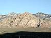
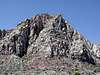
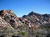
White Rock Mountain (aka White Rock Peak, White Rock Hills, White Rock Hills Mountain, and White Rock Hills Peak - the sign at the trailhead says "White Rock Mountain" while the USGS lists this as White Rock Hills), located in Red Rock Canyon National Conservation Area (RRCNCA or just "Red Rocks") 15 miles west of Las Vegas, is one of the less visited summits of the Red Rocks peaks. This summit does not see a lot of summit activity given challenging route finding and an abundance of more visually impressive neighbors that include: Bridge Mountain, Rainbow Mountain, Rainbow Wall, Turtlehead Peak, and Mount Wilson. The summit can, however, be reached by at least two routes, a YDS class 3 route and a YDS class 5 route, both involving significant route finding and starting from the White Rock Spring trailhead. If you choose to use the 3.5 mile YDS class 3 route, a detailed description is available from BranchWhitney's website, HikingLasVegas.com. Josh reached the summit on April 5, 2002 using an alternative approach starting with the Group Therapy (YDS 5.7) climb on the peak's Angel Food Wall. Of the summit route, he said "it involved fighting through a lot of thick brush and climbing lots of loose, licheny class 4 and some class 5. Routefinding was highly non-trivial." There is a summit register on top which is often buried in a cairn so look carefully if you want to sign it.White Rock Mountain is more popular with rock climbers than hikers or peakbaggers with many routes established on the mountain's Angel Food Wall including the popular Tunnel Vision and Group Therapy climbs, both YDS 5.7. Some climbers doing Tunnel Vision for the first time even bring headlamps for the "tunnel" on pitch 3, though this isn't necessary. Sheepskull Crag just south of Angel Food Wall on the mountain's east side also offers possibilities. The following is a partial list of routes on Angel Food Wall approached from the White Rock Spring trailhead:
| |||||||||||||||||||||||||||||
 |  |  |  |
Getting There
WHITE ROCK SPRING TRAILHEAD: Take NV SR-159 to the Red Rock Canyon Visitor Center. Drive 5.8 miles on the 13-mile Scenic Drive to the signed junction for White Rock Spring and turn right on to a gravel road. Follow the gravel road for 0.5 miles before reaching a parking area complete with out house. If you are going to Angel Food Wall, take the obvious dirt road, staying left at the junction 0.1 miles from the trailhead heading down to White Rock Mountain, eventually leaving the dirt road when you get close to Angel Food Wall.
Red Tape
An entrance fee is required for the RRCNCA and as of 2013 some options are: (1) $7 per vehicle, (2) $30 for an annual pass, or (3) $80 for an America the Beautiful Interagency Pass. The scenic drive is open from 6am to 5pm daily. If you are still inside Red Rocks after 5pm you maybe issued a ciation though this isn't always rigorously enforced.When To Climb
This peak can be climbed year round with the spring and fall often being the most pleasant. During the late spring and summer it can get very hot and there is little shade along the some routes so be prepared. During the winter, there is occasionally snow, but it doesn't last long so if you find it, enjoy it :-)Camping
Camping is not allowed in the RRCNCA and the hike is so short that camping isn't necessary, however, if you want ot stay in the area he "13-Mile Campground" is located just 2 miles east of the Visitor Center on NV SR-159. This is an improved BLM site that includes picnic tables, grills, water and toilets, however, no RV hookups are available. Permits are required and available by calling (702) 647-5050. Reservations are available for groups only. You can also get more information by contacting the RRCNCA listed under the Mountain Conditions Section.Mountain Conditions
BLM RRCNCA Weather PageYou can also contact the BLM RRCNCA:
BLM Red Rock Canyon National Conservation Area
HCR 33, Box 5500
Las Vegas, Nevada, 89124
Phone: (702) 363-1921
External Links
- Justin Cox's Jan 7, 2001 Tunnel Vision attempt where he meets Fred Beckey
- Hiking Las Vegas
Online hiking guide to southern Nevada
- Panorama from the summit of White Rock Hills Peak
Interactive panorama from the summit of White Rock Hills Peak.