
|
|
Mountain/Rock |
|---|---|
|
|
42.73441°N / 0.45044°E |
|
|
Hiking, Mountaineering, Mixed, Scrambling, Skiing |
|
|
Spring, Summer, Fall |
|
|
9724 ft / 2964 m |
|
|
Overview


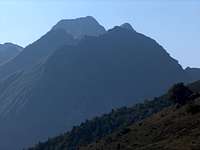
The "Hourgade", as we most commonly call it (often without "Pic de"), is a splendid peak which fails to reach the status of three-thousander for a story of meters, and which is located on the edge of the dense high region of the Luchonnais (amongst with Gourgs Blancs, Perdiguère, and so on).
The mountain is located on the north of the group, quite excentred from the border ridge, which make it an outstanding viewpoint when looking south.
It also lies on the ridge that separates the Luchon valley and the Louron valley (tributary of the Aure valley), and is equally accessible for mountainners starting form both trailheads.
The other particularity of the Hourgade is its striking shape, like a teeth. In summer, this is a trip involving steep scramble on loose rock; In winter, when the snow conditions are appropriate, it makes a very rewarding trip.
The first ascent took place on July 26th 1883 by Henry Brulle, Jean Bazillac and Célestin Passet.
The origin of the name "Hourgade" is not precisely known, however there are good chances it could mean "Fork" (it is a twin peak seen from West).
"Fourcade" comes from "fork-shaped" (ex: Forcanada, which is clearly the "twin-peak, the fork"). The same way, as often in local dialects, the H has replaced the F (like the word "Hourquette", which means a saddle after the fork shape, comes from "Fourquette", a small fork). We get this way "Fourcade", which is a common french patronym in the countryside, designating peasants.
 South panorama in winter South panorama in winter |
Getting There


Coming directly from the A64 motorway (either from Toulouse or Bayonne), the shortest is to drive via the Aure valley (Lannemezan exit) until Arreau , and then Louron valley, until the village of Germ.
However the other valley of Luchon is almost equal in time (Montréjeau exit), one needs to pass the resort of Luchon (perhaps more traffic there), in order to reach the trailhead of the Vallée d'Astau.
The aim of both trails is to aim the pass Col d'Esquierry, the start of the ascent of the peak.
A third option, also available from both valleys, is to reach the Col de Peyragudes, and the village of Peyresourde Balestas. Then, after climbing the peaklet of Montségu, we descend to the Col d'Esquierry.
From Spain, all trailheads are quite distant to reach. The most convenient is :
- From Eastern Spain, pass the Col de Bonaigua or Tunnel de Vielha, descend the Val d'Aran until Saint Béat, and catch back the Luchon valley
- From Western Spain, pass the Tunnel of Bielsa, descend the valley d'Aure until Arreau and catch back the Louron valley at Arreau.
View Larger Map
Routes
 Ourtiga hut
 Ourtiga hut
 Vallée d'Astau
 Lac d'Espingo
 Ourtiga hut
 Ourtiga hut
 Ascent
 Looking north
 Col d'Arrouge
 Col d'Arrouge
 Looking East
 Paragliding
 Hourgade valley
 Hourgade valley
* In Summer, there are three usual routes to climb the Hourgade. Many of them can be combinated to make a loop. The most frequent (and recommended) loop if the one combining both routes from the North side, Hourgade and Nère lakes.
Combining the third one with one of the others involve a huge trip, which is better to cut in two, spending a night at Ourtiga or Espingo.
- Hourgade route : From the Ourtiga hut, elevate into the valley of the Lac de Hourgade. Reach the base of the peak and elevate on the steep slope until the summit, with easy scrambles all along the way
- Nère Route : From the Ourtiga hut, elevate into the valley of the two Lacs de Nère, after passing the peaklet named "Pic de Brudaillet". Then, reach Lac d'Arouge and Col d'Arouge. Then, we can decide either to scramble the North-East ridge, or to go down a bit to reach the first itinerary.
- Espingo Route : From the Oô lake, reach the Espingo lake, and then elevate West to the Lac d'Arouge. Then, same itinerary as the second.
The most experienced mountaineers will possibly combine these routes with the ascent of smaller neighbouring peaks like Pic d'Espingo, or Pic de Belle-Sayette. These routes are described in the excellent page of Philippe Queinnec about the area (Google-translated here)
 Hourgade winter route Hourgade winter route |
* In Winter (rather spring indeed), The Hourgade route is the most proper one to reach the summit safely. When seen from far, we can notice that the north face of the Hourgade is barred by a diagonal more flat than the rest, running from top-left to bottom-right. This corresponds to a zone where walking with crampons is possible on a reasonnable slope. The base of this route is reached in the right corner of the valley of Lac de Hourgade, with a steep start.
The middle section, as described, is fine. Then the final is steep again. It ends somewhere on the East of the summit ridge. Then it is necessary to continue on the ridge until the summit, which is quite easy. Beware of remembering the place where the ridge was reached, it is easy to miss when going down.
 Hourgade map Hourgade map |
Red Tape
 From Loudenvielle
 From Esquierry
The Hourgade is not located in any National park, however beware of not leaving rubbish and so on...
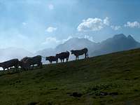
All mentionned trailheads are a common areas for cattle breeding; beware of pig-headed cows... :) Beware also when parking, one might find scratches of horns on the car body...
In winter or spring, make sure the avalanche risk is 0% and the snow very hard.
 West winter panorama
Camping


You can bivouac anywhere you want in the area, far from the road and villages, without any troubles.
Many mountaineers choose to bivouac in the excellent and locally well-known hut of Ourtiga (open to mountaineers but unguarded, only basic equipments). For this option, starting from the Louron valley is best.
For the Espingo route, we can also recommend to sleep at the Refuge d'Espingo
Concerning official campsites, there are many in both the Luchon and the Louron valley.
There are also many accomodations :
http://www.vallee-du-louron.com/
http://www.luchon.com/
Rafa Bartolome - Sep 15, 2009 10:28 am - Voted 10/10
the heightis 2964m and not 2064m...it's a little mistake of one number but it's a lot of meters for the peak, he,he thanks for the good page, I will search some pictures about it. I will write Gourdon and Belloc someday as well.
visentin - Sep 15, 2009 12:25 pm - Hasn't voted
Re: the heightCorrected ! Now I understand why my page got only 6 poor votes so far instead of the average of 15-20 for a standard new peak in the Pyrenees ! Sad to say, but seems that the popularity ranking of peaks pages on SP are narrowly linked to their height ! (perhaps more than the page content itself...)
Rafa Bartolome - Sep 15, 2009 2:42 pm - Voted 10/10
Re: the heightI don't know...it's not always true. The height is important but the people generally vote according with the pictures because a lot of them don't know really where are the Pyrenees and where's the peak. It's my impression. For me, one of my favourite climbs is Pic de Viscos (2.141m) still without page in SP and probably the smaller peak that I'll write in this area in the future. I know what the people will love the images of this beautiful pyramid peak. The votes depent in many times if the people are connected when the page appears in what's new. Good luck.
visentin - Sep 16, 2009 7:42 am - Hasn't voted
Re: the heightViscos => just make the page ! I'm going to make pages for some peaks under 2000m near St Lary in a near future... My next targets are the Suelsa and the Fulsa, I'm posting right now pleinty of pictures of them. As for heights, I may make an experiment, make a "temporary mistake", placing for example the Suelsa at 3800m for the first week just to see how the votes go ! :)