
-
 5932 Hits
-
 77.48% Score
-
 8 Votes
|
|
Mountain/Rock |
|---|---|
|
|
42.70540°N / 0.48314°E |
|
|
Mountaineering |
|
|
Spring, Summer, Fall |
|
|
9954 ft / 3034 m |
|
|
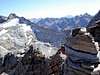
Overview


The Pic Gourdon (3.034m) is one of the most popular peaks of the group of Spijeoles (3.065m), at North of Gourgs Blancs (3.129m) because the summit is easy to climb from the col de Gourgs Blancs, important pass between both peaks. Many mountaineers and trekkers walk the beautiful route between Refuge de la Soula and Refuge du Portillon and a lot of them climb this peak from the col de Gourg Blancs. The last section near of the summit has an easy rock-climb (F.), across its ridge South. It’s not very difficult except if remain snow (it’s pronuntiated). The mountaineers can join the climb of this peak with the climb of the most important Spijeoles (3.065m), the highest peak of this group. In this case the better option is reach the col between Spijeoles and Gourdon climbing the normal route of Spijeoles (ridge South, F+) returning to col to climb Gourdon across its ridge North(F+), descending to col de Gourg Blancs across the normal route (ridge South, F.). As well, even if you don’t want to climb Spijeoles is a good option the climb of the beautiful ridge East of Gourdon because the narrow last section is impressive but with very good rock to handle. It’s one of the better easy rock-climbs of the area without rope.
 |
 |
 |
Getting There


Trailheads: Granges d’Astau, Pont de Prat.
Access to Granges d’Astau:
-French: the approach to the village of Montréjeau has good highways. The access to Montréjeau is in the road A-64 (E-80) between Tarbes and Toulousse. From Montréjeau we’ll follow to Bagnères de Luchon. In Luchon we'll follow the signals “Col de Peyresourde”. After 2-3 km in the village of Cazeaux de Larboust is the entry to the road of Granges d’Astau (1160m).
-Spanish: the access is possible at West in tunnel of Bielsa, or at the East, in the tunnel of Vielha.
-Approach to Bielsa: from Huesca to Ainsa. In Bielsa you'll take the tunnel of Aragnouet-Bielsa to France. It's necessary to reach the village of Arreau to turn to the east to Val Louron, the first valley of Luchon, or following across the Col of Peyresourde (1569m) and before of Bagnères de Luchon is the access (see above).
-Approach to Vielha: from the city of Lleida to village of Pont de Suert (N-230), and across the tunnel of Vielha you'll reach the valley of Aran. Before the village of Bosost is the road to Col du Portillon (1293m) to cross the border to France. The road D-618 go directly to Bagnères-de-Luchon.
Access to Pont de Prat:
Pont de Prat is easily reachable from the village of Loudenvielle. Loudenvielle is situated at west of Col de Peyresourde. The road of La Nested du Louron goes to the area of Pont de Prat (1255m). The access to Refuge de la Soula is across Gorges de Clarabides in 1h30m.
Red Tape
Natural Park of Pyrenees with rules about the wildlife, camping.Camping
Camping in vivouac it's allowed at 1 hour of some refuge but it's not a good option because it exists good refuges keepts in the routes.Granges d’Astau:
-Refuge d'Espingo (2h)
-Refuge du Portillon (4h).
Pont du Prat:
-Refuge de la Soula(1h30m)