
-
 7390 Hits
-
 83.1% Score
-
 16 Votes
|
|
Mountain/Rock |
|---|---|
|
|
42.71014°N / 0.48475°E |
|
|
Mountaineering |
|
|
Spring, Summer, Fall |
|
|
10056 ft / 3065 m |
|
|
Overview
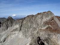 Belloc & Spijeoles
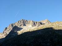 NE face
The Pic Spijeoles is one of the most importants of the Cirque d’Espingo. This cirque over the Lac and Refuge d’Espingo has in left (East) the great presence of Quayrat (3060m), the pyramid of Tusse de Montarcqué (2889m), in the middle, and a little range with rocky walls in the right (West) with the peaks Spijeoles (3065m), Belloc (3008m) and Hourgade (2964m). Because the highest Lézat (3107m) is not visible from Espingo, it's behind the Quayrat, the Spijeoles is the highest peak of the cirque but it's not really important, it's a very nice peak with ridges of good rock and two easy rock-climbs, specially the ridge NW that joins this peak with Belloc (F.sup., exposed in some places). The normal route from Refuge d'Espingo or from the nearby Refuge du Portillon is F. (easy rock-climb) across some terraces of rock not exposed. The accesses from the west from the Refuge de la Soula precise to cross the Col of Gourgs Blancs with a descent to get the normal route (for this reason in many occasions the rock-climbers make first the peak Gourdon but the ridge North to descent of this peak is F.sup. exposed; this ridge is better to make in the ascent at return if you want to make this peak as well).
Because the normal route from Espingo (1960m, 2h from Astau) or Portillon (2571m, 4h from Astau) is long, generally it's necessary to spend a night in one of the refuges after a walk the previous day from Granges d’Astau.
The other access to the peak is from Val Louron. The Refuge de la Soula (1800m), with access from Pont de Prat in 3h, it’s the first stage to climb the peak across the Lac Caillauas and the Col of Gourgs Blancs.
The rock-climbers has in this peak a classic superb climb in the famous “diedro” with degree V, directly to the summit in the north face.


Getting There
 Astau
AstauTrailheads: Granges d’Astau, Pont de Prat.
Access to Granges d’Astau:
-French: the approach to the village of Montréjeau has good highways. The access to Montréjeau is in the road A-64 (E-80) between Tarbes and Toulousse. From Montréjeau we’ll follow to Bagnères de Luchon. In Luchon we'll follow the signals “Col de Peyresourde”. After 2-3 km in the village of Cazeaux de Larboust is the entry to the road of Granges d’Astau (1160m).
-Spanish: the access is possible at West in tunnel of Bielsa, or at the East, in the tunnel of Vielha.
-Approach to Bielsa: from Huesca to Ainsa. In Bielsa you'll take the tunnel of Aragnouet-Bielsa to France. It's necessary to reach the village of Arreau to turn to the east to Val Louron, the first valley of Luchon, or following across the Col of Peyresourde (1569m) and before of Bagnères de Luchon is the access (see above).
-Approach to Vielha: from the city of Lleida to village of Pont de Suert (N-230), and across the tunnel of Vielha you'll reach the valley of Aran. Before the village of Bosost is the road to Col du Portillon (1293m) to cross the border to France. The road D-618 go directly to Bagnères-de-Luchon.
Access to Pont de Prat:
Pont de Prat is easily reachable from the village of Loudenvielle. Loudenvielle is situated at west of Col de Peyresourde. The road of La Nested du Louron goes to the area of Pont de Prat (1255m).
Red Tape
Natural Park of Pyrenees with rules about the wildlife, camping.Camping
Camping in vivouac it's allowed at 1 hour of some refuge but it's not a good option because it exist refuges keepeds in the routes.Granges d’Astau:
-Refuge d'Espingo (1h30m)
-Refuge du Portillon (4h).
Pont du Prat:
-Refuge de la Soula(1h30m)