

-
 41275 Hits
-
 95.43% Score
-
 53 Votes
|
|
Mountain/Rock |
|---|---|
|
|
45.99285°N / 7.41740°E |
|
|
Mountaineering |
|
|
12697 ft / 3870 m |
|
|
Overview

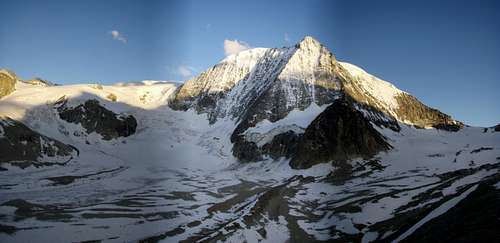
Setting - from the W
The Mont Blanc de Cheilon forms the end of the Val des Dix  . It has a beautiful pyramidal form with its clear-cut north face. It's a rewarding, easy summit via the normal routes and a difficult challenge via the north face. Especially the traverse from the Col de la Serpentine to the Mont Blanc de Cheilon is recommended (perhaps in combination with the Pigne d'Arolla). Both summits of the normal routes are often the goal of ski mountaineers during the winter and late spring.
The pyramid of the Mont Blanc de Cheilon has a quite severe N-face which is framed by two sharp rock ridges and is the reason for its elegant silhouette. The summit ridges often have snow and cornices.

From the NW
During the past 30 years, most north faces of the Walliser Alps have changed very much due to warmth and drought, including the north face of the Mont Blanc de Cheilon. In former times, the north face had snow and ice all year with only a few rocks showing near the summit. Today during summer, the only ice is in the big couloir in the middle of the face.
If the snow conditions are good and the snow amount adequate, climbing the N-face is not too difficult. You only get into difficulties in the upper part if there is no snow, because the rocks are loose. Therefore, during the past years, many new routes have been opened which exit the face to the ridges.
In contrast to these problems, the ridges have rock that is mostly very good with good opportunities for belays.
Getting There

Dix Reservoir
From near the dam
Cabane de Dix is the base for most climbs.
- From the Dix-Stausee (Val d'Hérémence): In 3 h from the dam wall (570 m gain). A cable car (phone: ++41(0)272811282) goes from the parking place Le Chargeur (2141m) to the dam (2365m) or hike 40 min. From there, you follow the road to the E-side of the lake to the S-end (P. 2386m). A trail goes over the "Pas du Chat" around the NW-end of the Luette and above the glacier tongue on the left moraine to the rock shelf Tête Noire. After that, you go to the left and up to the hut. This way is NOT recommended during winter because of avalanche danger.
From Arolla: In 3 h, 1000 m gain. The road goes to the uppermost chalets of Arolla (about 2120m); then a private road to the Alm La Remointse (2409m). The cable cars in winter go up to 2450 m. From Arolla you go 45 min. on a road via the cable car region to Remointse and further on a very well marked hiking trail heading east to the Pas du Chèvres, the lowest saddle in the crest between Mont Rouges and the Pointes de Tsena Refien (1 h).![Echelles du Pas de Chèvre]()
On Arolla Approach - Then you climb over 2 vertical ladders about 30 m down a rock face and traverse on trail to the S to the Cheilon Glacier. You traverse this glacier in SW-direction to the Tête Noire. Afterward, you climb up about 100hm on the trail from the Dix-reservoir to the hut (45 min.). This is the normal winter ascent (3h from Arolla)
- From the Prafleuri-Hütte over the Col des Roux: in 3.5 h. This part of the Hiking-Haute-Route Verbier-Arolla goes over the Col des Roux to the grazing meadows of La Barma (1 h) and meets the way via the Dix-reservoir. This is also a ski approach.
Accomodations

Sion and Arolla as well as villages between have a variety of camping, hotels and pensions. This is a popular region and reservations are advised.
Cabane de Dix
 Dix Hut Dix Hut |
 Dix Hut Dix Hut |
 Dix Hut Dix Hut |
Routes-Overview

On the SW Ridge
This is merely a listing of the more popular routes. Consult a guidebook for more details.
1. W-flank and SW-ridge (normal route):
L, UIAA I, 950 vertical meters, 4 to 4 1/2 h from the Dix hut.
2. E-ridge (traverse from Col de la Serpentine):
ZS, UIAA III, 330 vertical meters, 4 h to 4.5 hours from the Dix Hut
3. NW-ridge (Gallet-ridge):
ZS,UIAA IV, 942 vertical meters from the hut (the ridge is 670 vertical meters), 3-5 hours total.
4. NNE-ridge (Jenkins-ridge):
ZS+, UIAA IV, 942 vertical meters from the hut (The ridge is 830 vertical meters), 4-6 hours total.
5. Northface:
SS, UIAA V with ice and snow to 57°, (during recent years much less snow),942 vertcal meters (The face 670 is vertical meters.), 6-8 h total.
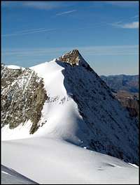 East Ridge East Ridge |
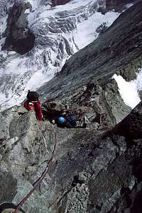 On the East Ridge On the East Ridge |
 On the East Ridge On the East Ridge |
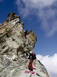
 Last part SW Ridge Last part SW Ridge |
View from the summit
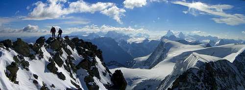 Summit panorama (enlarge for excellent detail)Photo by Sebastian Hamm
 To Lake Dix To Lake Dix |
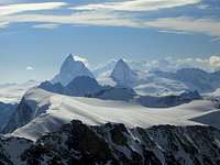 To Matterhorn To Matterhorn |
 To Mt Blanc To Mt Blanc |
Other Information and Resources
Swiss topographic maps:
1:25000 no. 1347 Matterhorn and 1346 Chanrion
1:50000 no. 283 Arolla
Weather and Avalanche information
Books
- Hermann Biner, Hochtouren im Wallis. Vom Trient zum Nufenenpass. 2nd ed. 1996. ISBN 3-859022-160-5
- Michel Vaucher, Walliser Alpen: Die 100 schönsten Touren.2nd ed. Munich 1990. ISBN 3-7654-2124-3
- Michael Waeber, Walliser Alpen. DAV-Gebietsführer. 12th ed. Munich 1999. ISBN 3-7633-2416-X
- Maurice Brandt , Walliser Alpen 2, SAC Clubführer. Order from Swiss Alpine Club Publications
External Links
- April Ski Tour Mont Blanc de Cheilon
A very nicely done trip report page with excellent photos.
In Memoriam
The last maintainer of this page and early SummitPost member Rahel Maria Liu died 24/25 August 2004 after being caught in a freak snowstorm while attempting to climb the Innominata Spur on the southern (Italian) face of Mont Blanc. She was only 34 years old.