
-
 2442 Hits
-
 82.48% Score
-
 15 Votes
|
|
Mountain/Rock |
|---|---|
|
|
45.87270°N / 7.31948°E |
|
|
Mountaineering |
|
|
Spring, Summer, Fall, Winter |
|
|
7835 ft / 2388 m |
|
|
Overview
Small Summit placed west of the Western Crest Monte Berrio (3.205m) and the pass of the same name. Easily accessible from the Southern Slopes of Comba or barked and Northern or Basin dell'Acqua Bianca (Water White Basin), presents instead westward high rocky cliffs overlying the Municipality of Ollomont. Tiny Cross collocated on Summit. This excursion, can be performed with good snow conditions even with Snowshoes, it has a twofold itinerary that can be connected indifferently between the ascent and descent. Always with departure and following arrival to Ollomont Common. Nice views towards the Mont Velan (3.734m) and the Grand Combin de Grafeneire (4.314m) and the underlying broad "Conca" or Basin of By, above all on the below "Comba dell'Acqua Bianca" ("White Water Basin").

Piccola Sommità posta ad Ovest della Cresta Occidentale del Monte Berrio (3.205 m) e dell'omonimo colle. Facilmente raggiungibile dai Versanti Meridionale o Comba del Berrio e Settentrionale o Conca dell'Acqua Bianca, presenta invece verso Ovest alti dirupi rocciosi soprastanti il Comune di Ollomont. Piccola Croce posizionata in Vetta. Di quest'Escursione, effettuabile con buone condizioni di neve anche con Racchette da neve, si propone duplice itinerario che può essere collegato in modo indifferente tra la salita e la discesa. Sempre con partenza ed arrivo ad Ollomont. Bei panorami verso il Mont Velan (3.734 m) ed il Grand Combin (4.314 m) e la sottostante larga Conca di By, soprattutto sulla sottostante "Comba dell'Acqua Bianca".
First Ascents
- First on the Summit: Unknown.
- In winter: Unknown.
Getting There
BY CAR:
- From TORINO, MILANO, etc: Motorway A5. Exit at Aosta East
- From FRANCE: through the Mont Blanc Tunnel to Entrèves/Courmayeur. By Little Saint Bernard Pass, closed since November until half May to La Thuile Valley - Pré Saint Didier - AOSTA Municipalities. It is not necessary to take Motorway A5: you can drive on State Road n°26, in the direction of AOSTA - IVREA - TURIN.
BY PLANE:
- Aeroporto "Corrado Gex" Saint Christophe (Aosta).
Specific Road
From Aosta East exit of the motorway, follow along the SR.27 for the Gran San Bernardo Tunnel. After about ten Km turn to the right (Northeast) towards Valpelline (964m), creoss it and turn to the left to get Ollomont (1.335m) and the small built area of Glacier (1.549m), where you must start walking.
Dall'uscita del Casello Autostradale di Aosta Est, proseguire sulla SS.27 in direzione del tunnel del Gran San Bernardo al confine con la Svizzera; dopo circa un decina di chilometri svoltare sulla destra (Nordest) verso il Paese di Valpelline (964 m). Dopo averlo superato svoltare sulla sinistra (Nord) e raggiungere il Paese di Ollomont (1.335 m); proseguire sino alla Frazione di Glacier o Glassier (1.549 m), dove inizia l'itinerario a piedi.
 |
 |
 |
 |
 |
Approachs and Routes
A) - (Through the Comba of Berrio) from Ollomont Commune, Cognen locality beyond the Churc (+; 1.356m), through the dirt road and following path n° 6/7/Alta Via n° 1 in terminal part from fork 1.725 meters towards Berrio Dèsot Pasture (1.720m; T; 2h'00/2h'10), below Southern Crest of Mont Corm(n)et and the homonym Hill. Continue through the same path towards the source about 1.845 meters immediately before Berrio Damon or Upper (1.932m; E; 2h'45/3h'15), in tableland below Monte Berrio. From Berrio Damon Alpage, with path before in Northwest, towards Tsa de Berrio Upper Alp (2.165m), after in Northeast to Cornet Hill (2.354m), above Cornet Loch (2.335m). From this, tourning left (West) through a small path not numbered and traces easily to Mont Cornet with a Cross (2.388m; E/F; 0h'40 from the pass).
B) - (Passing nearby Gaula Oratory) From the Village of Glacier (1.562m), reached by the Regional Road from Ollomont, take path n° 6 that, over the bridge at a wooden fountain, rises to the Alp Crottes and reaching the Oratory of the Gaula (1.591m; 1.863m); from this, flexing more toward the Northeast is reached to Planet (2.150m) at the entrance of the "Comba des Eaux Blanches". At the next junction at 2.220 meters, at the Torrent Fenêtre, he leans toward Southeast coming to the Col Cornet and Lake (2.334m, 2.355m), encountering the trail n°6/7/Alta Via n° 1 which dates directly from Ollomont-Croux (1.330m).
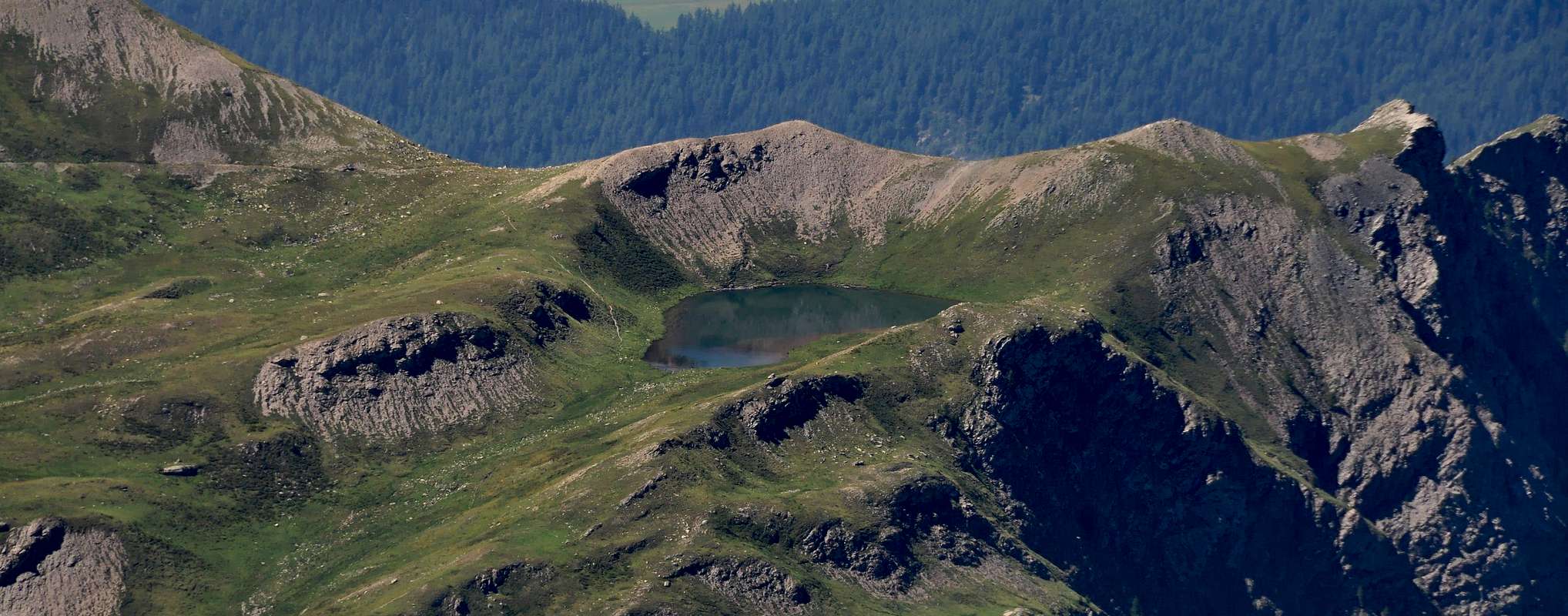
A) - (Attraverso la Comba del Berrio) Dal Comune di Ollomont, località Cognen subito dietro alla Chiesa (+; 1.356 m), per mezzo della strada poderale e successivo sentiero n° 6/7/Alta Via n° 1 nella parte terminale dal bivio 1.725 metri insino all'Alpeggio Berrio Dèsot o di Sotto (1.720 m; T; 2h'00/2h'10), sottostante la Cresta Meridionale del Mont Cornet nonché l'omonimo colle. Continuare per mezzo del medesimo sentiero in direzione della sorgente a circa 1.845 metri immediatamente precedente l'Alpeggio di Berrio Damon o Superiore (1.932 m; E; 2h'45/3h'15), sito nel piccolo altipiano al di sotto del Monte Berrio. Da questo alpaggio, tramite il sentiero, dapprima verso Nordovest, verso la Tsa de Berrio od ultimo alpeggio (2.165 m), quindi a Nordest in direzione del Col Cornet (2.354 m), appena al di dopra dell'omonimo lago (2.335 m). Dal colle, voltando a sinistra (Ovest) tramite un sentierino non numerato alternato a tracce con facilità si raggiunge il Mont Cornet con la sua Croce (2.388 m; E/F; 0h'40 dal colle).
B) - (Passando dall'Oratorio della Gaula) Dal Villaggio di Glacier (1.562 m), raggiungibile con la Strada Regionale da Ollomont, prendere il sentiero n° 6 che, oltrepassato il ponte presso una fontana in legno, risale verso l'Alpeggio di Crottes raggiungendo l'Oratorio della Gaula (1.591 m; 1.863 m); da questo, flettendo maggiormente in direzione Nordest si raggiunge quello di Placet (2.150 m) all'ingresso della "Comba des Eaux Blanches". Al successivo bivio 2.220 metri, presso il Torrent Fenêtre, si piega verso Sudest arrivando al Lago ed al Col Cornet (2.335 m, 2.355 m) incontrando il sentiero n° 6/7/Alta Via n° 1 che risale direttamente con partenza da Ollomont-Croux (1.330m).
Difficulty
These routes can be considered E/F and EE/F+ for the Snowshoing.
Gli itinerari sono da classificare in E/F ed EE/F+ per le Racchette da neve.
Equipment
For Hiking gear or with Snowshoes.
Da Escursionismo o con Racchette da neve.
 |
 |
 |
 |
 |
Campings
Remember that free camping is forbidden (except for emergency reasons, over 2.500m, from darkness until dawn).
Mountain Conditions
- You can get meteo information at the official site of the Regione Valle d'Aosta:
- Valle d'Aosta Meteo
Webcam
- WEBCAM on Aosta Valley:
- Webcam
Books and Maps
- "Guida dei Monti d'Italia-Alpi Pennine" (Vol. I°) di Gino Buscaini-Club Alpino Italiano/Turing Club Italiano, Luglio 1971 (in Italian).
- "Diari Alpinistici" di Osvaldo Cardellina e Indice Generale accompagnato da Schedario Relazioni Ascensioni 1964-2019 (inediti).
- "Guida della Valpelline" de l'Abbè Joseph-Marie Henry - Societè Editrice Valdotaine 1925 II Edition e Collana Reprint Musumeci (1986).

|

|
MAPS:
- Kompass "Massiccio del Monte Bianco Valle d'Aosta" Carta escursioni, bike e sci alpinismo 1:50.000.
- L'Escursionista "Valpelline, Saint Barthélemy" (carta n° 6) 1:25.000.
- C.N.S. "Mont Vèlan", foglio 1366, 1:25.000.
- Kompass "Breuil/Cervinia-Zermatt" Carta escursioni, bike e sci alpinismo 1:50.000.
- I.G.C. Istituto Geografico Centrale "La Valpelline, Ollomont, Saint Barthélemy", (carta n° 115) Map1:30.000.

|

|
Important Information
- REGIONE AUTONOMA VALLE D'AOSTA the official site.
- FONDAZIONE MONTAGNA SICURA Villa Cameron, località Villard de la Palud n° 1 Courmayeur (AO) Tel: 39 0165 897602 - Fax: 39 0165 897647.
- SOCIETA' DELLE GUIDE DELLA VALPELLINE Etroubles-Strada Nazionale, n° 13 - Tel +39 0165 78559 - Valpelline-Loc Capoluogo, n° 1 - Tel +39 0165 713502 (AO) Italia.
- A.I.NE.VA. (Associazione Interregionale Neve e Valanghe).
Useful numbers
- Protezione Civile Valdostana località Aeroporto n° 7/A Saint Christophe (Ao) Tel. 0165-238222.
- Bollettino Meteo (weather info) Tel. 0165-44113.
- Unità Operativa di Soccorso Sanitario Tel. 118.
Acknowledgements
I am greatly indebted to my friend "Osva" for the detailed description of the route.