
-
 755 Hits
-
 82.48% Score
-
 15 Votes
|
|
Mountain/Rock |
|---|---|
|
|
44.40464°N / 9.98884°E |
|
|
Emilia-Romagna |
|
|
Hiking, Mountaineering, Scrambling |
|
|
Spring, Summer, Fall, Winter |
|
|
5965 ft / 1818 m |
|
|
Overview
Geographical classification: Appennino Tosco-Emiliano e Tosco-Romagnolo > Appennino Parmense > Bràiola
Monte Bràiola 1819 m
Monte Bràiola 1819 m is a summit located on the main watershed between the regions of Emilia-Romagna and Toscana and belonging to the Appennino Parmense Orientale, a chain in the Eastern part of Parma province. Monte Braiola is a rather important orographic node, as in correspondence to this mountain the watershed changes direction from North/South to NW/SE with a sharp turn to the right.
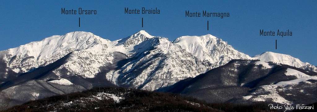
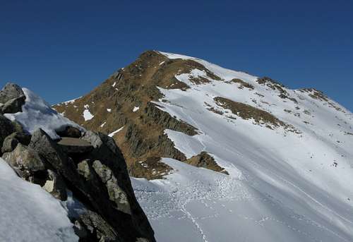
On the Parma side it rises with uniform slopes of moderate gradient from the Braiola basin where it is located the Capanna Schiaffino, while on the Lunigiana side (Tuscany) it appears very steep and varied in the shape of a pyramidal peak, high and elegant. To the south-west (Lunigiana) Monte Bràiola branches off the important rib that descends to the small saddle of the Portile, to then form the wide cap of Monte Logàrghena. The mountain lies between the most popular and well-known Monte Marmagna and Monte Orsaro, from which it is respectively separated by means of the saddles named Sella del Braiola 1702 m and Bocchetta dell'Orsaro 1722 m.
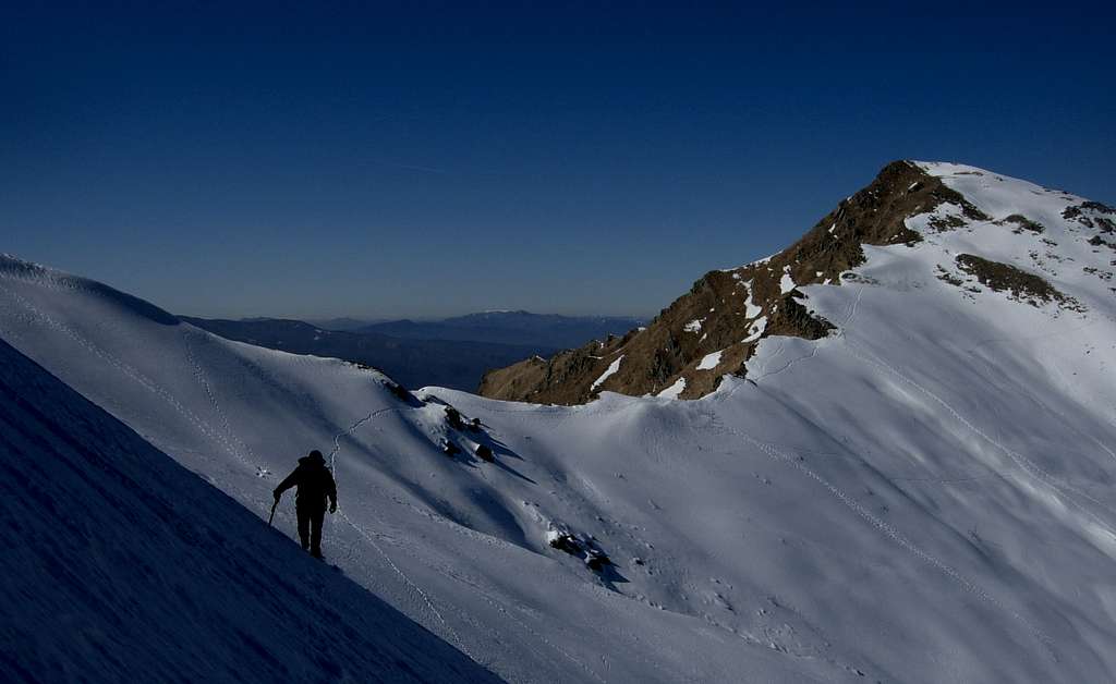
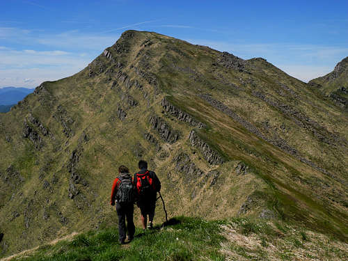
It is climbed as a stand-alone destination, but more often it is combined with the two peaks mentioned above to make beautiful ridge crossings. The Normal route, starting from the Rifugio Lagdei and running on the SE ridge, it's gently sloping towards the Sella del Braiola. It's a panoramic and popular summer walking which can also be done in winter without particular difficulties with the necessary gear in case of snow and ice (ice axe and crampons or snowshoes and skis depending on the snow conditions), as can also the opposite N ridge, which is slightly steeper. The two crests can be combined to cross the mountain.
Getting There
Road access
Parma is the nearest town, a 200.000 inhabitants town with a small airport, offering some domestic flies and only a few international ones. A good choice of international flies is provided by Milan and Bologna International Airports, both situated at a reasonable distance (Milan 110 km., Bologna 90 km.). Parma is linked to other Italian and European towns by A1 and A15 motorways.
- Approach from A15 (Autocisa Motorway) – If you’re driving on A15 towards North, exit Pontremoli and follow the road to Passo del Cirone and Bosco di Corniglio. From here follow the road towards the locality named Cancelli. If you’re driving on A15 towards South it’s better to exit Borgo Val di Taro and follow the road to Passo del Sillara and Bosco di Corniglio.
- Approach from Parma
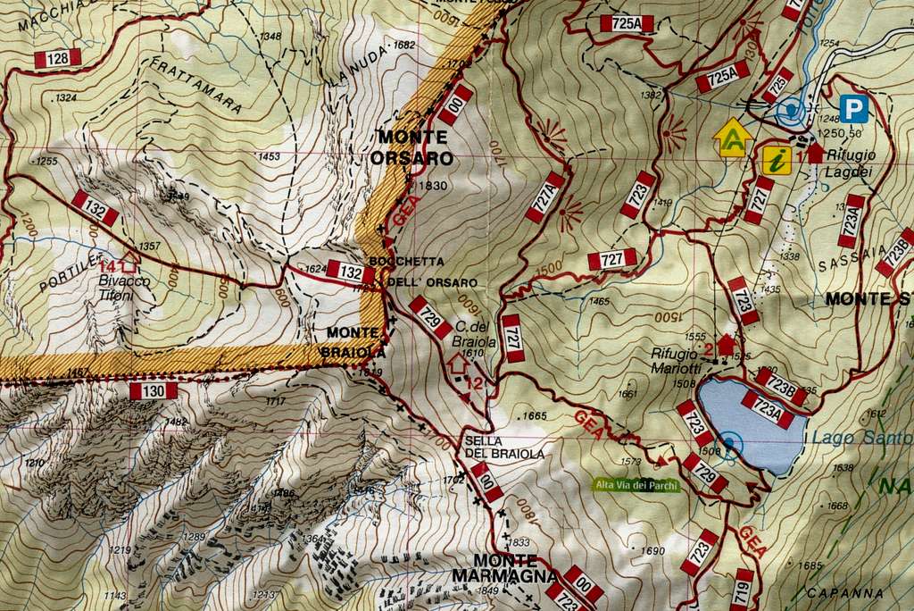
Follow the SP 665 (Massese) towards Langhirano and Capoponte; pass Langhirano and at Pastorello roundabout turn to right, reaching Corniglio, Bosco di Corniglio, the locality named Cancelli and finally Lagdei (wide parking).
Walking approach to Capanna Roberto Schiaffino
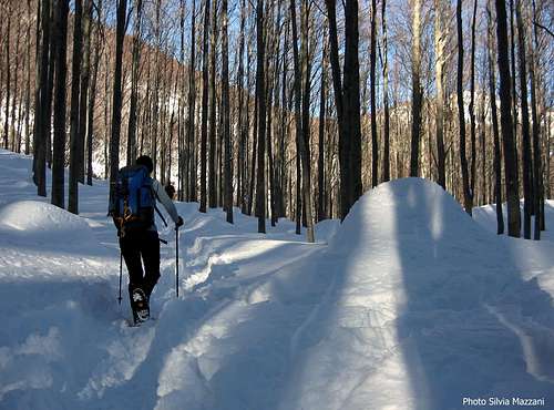
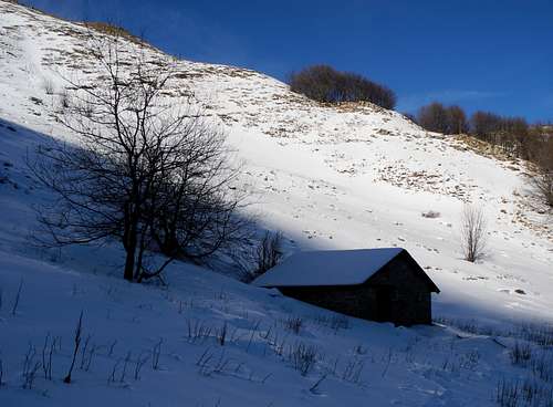
From Rifugio Lagdei follow the path n. 727, starting just near the shelter and rising inside the beautiful beech-wood; after the fork with the path leading to Rifugio Mariotti, starting on the left at about 1400 m. of altitude, the trail is getting to Ponte Rotto, so named in reason of a broken stones-bridge. Carry on always on the main path, without following the tracks starting from the main path, both on the left side and on the right, reaching the wild basin lying at the footh of Monte Marmagna, Monte Braiola and Monte Orsaro triad. Here is situated the small and secluded Capanna Schiaffino m. 1610, an emergency cabin always open (no beds).
Main routes to the summit
The two ridges described below are the easiest and most popular routes to climb the mountain and can be combined both ways to do the crossing.
South-East Ridge or Normal Route
Difficulty: Alpine F in winter condition, otherwise E
Vertical gain: 581 m.
Starting point: Lagdei m. 1250
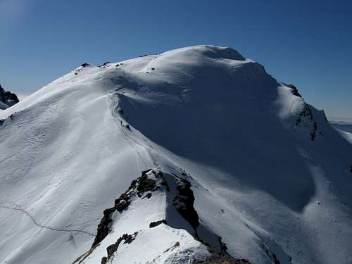
From Lagdei m. 1250 follow the path n. 727, starting just near the hut, crossing soon a wooden bridge and rising inside the beautiful beech-wood; after the fork with the path to Rifugio Mariotti, starting on the left at about 1400 m., the trail is getting to Ponte Rotto, so named in reason of a broken stones-bridge. Carry on always on the main path, ignoring both the trails forking from the main one both on the left side and on the right, reaching the Conca del Braiola, a wild basin lying at the footh of Monte Braiola, locted between the Monte Marmagna to the left and the Monte Orsaro to the right. Here is situated the small and secluded Capanna Schiaffino. From the shelter head to South, climbing directly the slopes above to reach the Sella del Braiola, between Marmagna and Braiola. From the saddle turn to the right and follow the ridge without difficulty reaching the summit. The top is marked by a small grassy or snowy shelf, depending on the season, where there is a CAI signpost and an ancient boundary stone between the Duchy of Parma and the Grand Duchy of Tuscany.
North Ridge
Difficulty:Alpine F in winter condition, otherwise E
Vertical gain: 581 m.
Starting point: Lagdei m. 1250
Same approach as the previous route, but from the Capanna Schiaffino head to North (right), traversing a steep slope and reaching the narrow saddle named Bocchetta dell’Orsaro m. 1722. From the saddle turn to the left and follow the ridge (slightly steeper than the previous route) without difficulty reaching the summit.
Essential gear
From May to November normal clothing and equipment for hiking. Warm clothing and equipment for the progression on snowy ground, an ice axe and crampons may be required in case of frozen ground in the wintertime. Snowshoes and skis depending on the snow conditions.
Red Tape
No fees no permits required. Monte Bràiola is located inside Parco Nazionale Appennino Tosco-Emiliano, established in 1922. Fires are strictly forbidden and the whole fauna and flora is protected. Don’t disturb fauna and other mountaineering and hikers’ peacefulness with every kind of noise.
When to Climb
It’s possible to climb and hike all round year on Monte Bràiola; winter ascents require the essential gear as crampons and an ice-axe.
Huts and bivouacs
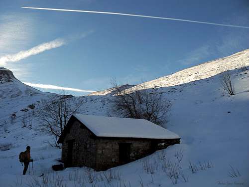
- Rifugio Lagdei m. 1250 Always open on Saturday and Sunday - From 15 June to 15 September and from 26 December to 6 January, 25 beds (60 km. from Parma); wide parking
- Capanna Roberto Schiaffino m. 1610 emergency shelter – 1 hour from Lagdei without snow, from 1,10 to 1,45 hours in winter, depending by the snow conditions
Climate
Climate is subcontinental, with cold and snowing winters and pleasant summers, dry but not too hot, because of the mitigating influence of the Tyrrenian Sea and the action of the winds.
Bibliography

"Arrampicaparma" III edition - Alberto Rampini and Silvia Mazzani - Idea Montagna ed. 2019 - A detailed guidebook including Multipitches,

Crags, Ice-falls and winter mountaineering in Appennino Parmense
"Arrampicaparma - Climbing, bouldering & mountaineering" by Silvia Mazzani and Alberto Rampini - Pareti e Montagne Edizioni, II ed. 2011 -
"Arrampicaparma - montagna, falesie, bouldering" by Alberto Rampini and Silvia Mazzani - Pareti e Montagne Edizioni, 2003
“Appennino Ligure e Tosco-Emiliano” by M. Salvo and D. Canossini - Collana Guide dei Monti d'Italia CAI-TCI
Maps
Click below on the link to CAI PARMA website to see the
Appennino Parmense online maps
- “Alto Appennino Parmense Est” Map 1:50.000 (CAI-Regione Emilia-Romagna)
Meteo forecast
- Meteo ARPA Emilia-Romagna
- Meteo Lagdei
External links
Club Alpino Italiano Sez. Parma
Parco Nazionale Appennino Tosco-Emiliano