
-
 1753 Hits
-
 82.48% Score
-
 15 Votes
|
|
Mountain/Rock |
|---|---|
|
|
45.77147°N / 7.79530°E |
|
|
Mountaineering |
|
|
8766 ft / 2672 m |
|
|
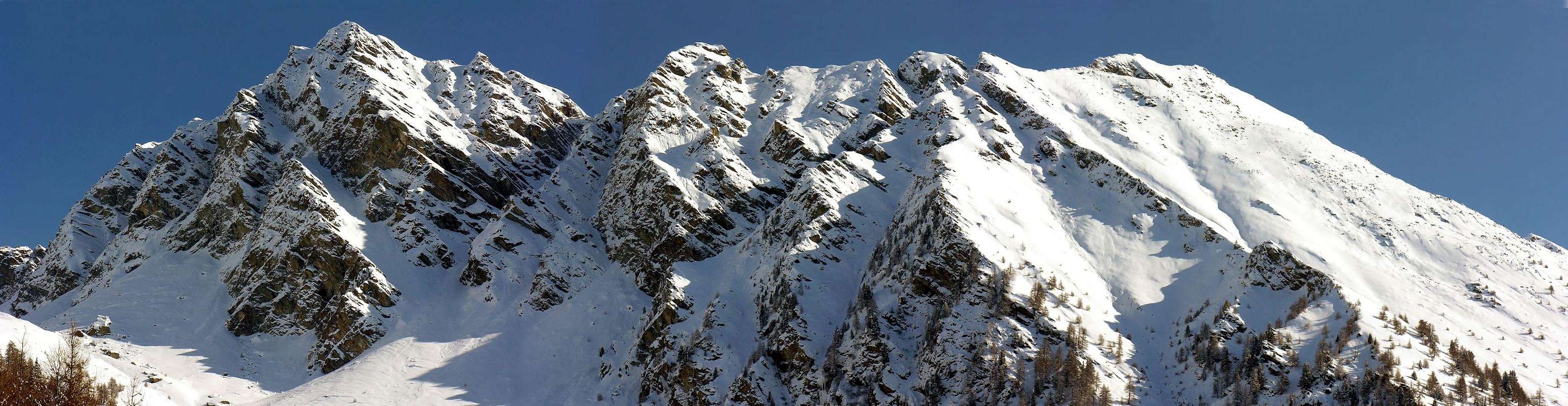
Overview
This triple mountain straddles two colors that connect the Ayas Valley to Gressoney or Lys. Formed in fact three distinct Summit, stretching from the South or from the Pass of Ranzola or in Walser dialect Arescoll (2.171m), to the North until the Bocchetta (Nozzle) of Eclou (2.522m), Punta has a South-southeast just above the first (2.647m), a Central (2.672m) and a North (2.662m) which dominates the second, before the crest flex most at Northwest towards the Punta Valnera or Valdònierhòre (2.754m). But the Mont Ciosé or Stallerhorn and still Stallerhòre and, locally, Mont Tiosé is to be placed on the first or the South of the three floors, while the other two are unnamed and reported as simple Quotes. It is rarely climbed, although records at least two winter ascents: in 1988 for the North Wall in 2001 and along the Ridge South-southeast. Also made the entire journey from South to the North (Ranzola/Bocchetta d'Eclou), on a single occasion and in solo ascent in 1982; the same appears longer and more complicated to search for the via that does not difficult. The Normal Route is enough simple and not very difficult but requires care (especially if there is snow or ice) at the carving 2.621/11 meters, very exposed facing North and vertical of about ten meters around the Summit. Beautiful views of the nearby side Valleys of Ayas and Gressoney, in the North on Testa Grigia (Grey Head; 3.314m) and the Monte Rosa mountain range, while in the South the view is towards Mount Nery or Becca Frudiera (3.075m) and in the distance on the whole circle of Graian Alps.
Questa triplice montagna si trova a cavallo di due colli che mettono in comunicazione la Valle di Ayas con quella di Gressoney o del Lys. Formata infatti da tre distinte Sommità, che si allungano da Sud, ovvero dal Colle della Ranzola o in dialetto walser Arescoll (2.171 m), a Settentrione fino alla Bocchetta di Eclou (2.522 m), presenta una Punta Sud-sudest subito al di sopra del primo (2.647 m), una Centrale (2.672 m) ed una Nord (2.662 m) che domina il secondo, prima che la cresta spartiacque fletta maggiormente a Nordovest in direzione della Punta di Valnera o Valdònierhòre (2.754 m). Ma il Mont Ciosé o Stallerhorn ed ancora Stallerhòre e, localmente, Mont Tiosé è da collocare sulla prima o Meridionale delle tre elevazioni, mentre le altre due risultano innominate e segnalate come semplici Quote sia nelle Carte che bella Guida t.C.I./C.A.I. del "Monte Rosa". Viene raramente salito, anche se registra almeno due ascensioni invernali: nel 1988 per la Parete Nord e nel 2001 lungo la Cresta Sud-sudest. Effettuata anche l'intera traversata da Sud verso Nord (dal Colle della Ranzola insino alla Bocchetta di Eclou), in un'unica occasione ed in solitaria nel 1982; la stessa si presenta più lunga e complicata per la ricerca della via che non difficile. La Via Normale non presenta grandi difficoltà ma richiede una certa prudenza (soprattutto in presenza di neve o ghiaccio) presso l'intaglio 2.621/11 metri, esposto a Settentrione nonché verticale di una decina di metri nelle vicinanze di una piccola sella antecedente di poco la Vetta. Belle vedute laterali sulle adiacenti Valli di Ayas e Gressoney, a Settentrione sulla Testa Grigia (3.314 m) e sulla Catena del Monte Rosa, mentre a Mezzogiorno la vista si dirige verso il Mont Nery o Becca di Frudiera (3.075 m) ed in lontananza sull'intera cerchia delle Alpi Graie.
First Ascents
- First on the Summit: Unknown.
- In winter: Pier Luigi Ferrero, lone; Feb 21th, 1988, in ascent by North Face. Second: Osvaldo Cardellina and Emilio Bertona, Jan 03th, 2002 from Ranzola Pass.
- North Wall: Pier Luigi Ferrero, lone, Feb 21th, 1988, in ascent from Gressoney St. Jean through Staller Alp.
- South-southwest Edge and Slope: Osvaldo Cardellina and Emilio Bertona, Jan 03th, 2002, in descent from Quota 2.571 meters to Praz Barmasse Damon.
- Integral Traverse South/North: Alessandro Gogna, lone, Aug 14th, 1982, in ascent by South-southeast Crest.
Getting There
BY CAR:
- From TORINO, MILANO, etc: Motorway A5. Exit at IVREA or Quincinetto (PIEDMONT).
- From IVREA Town: in West (Southern side) to Pont Saint Martin, Verrès Municipalities in East from Aosta Town.
- From Courmayeur Resort: in East-southeast to Aosta, Nus, Chatillon, Saint Vincent, Verrès Municipalities.
BY PLANE:
- Aeroporto "Corrado Gex" Saint Christophe (Aosta).
Approachs and Route
Approach Estoul Resort through Ranzola Pass: from Estoul, through dirt road concomitant with the trail n° 7 in East, towards Fenillettaz, Murassaz (1.883m), Praz Barmasse Dèsott (1.928m; not transit signal) Pastures, alternative 2.014 meters, Fenêtre Alp (2.083m) towards the Ranzola Pass or Arescoll (2.171m; T; 1h'20/1h'40), between Mont Ciosé or Stallerhòre (2.672m) Punta della Regina (+; 2.387m). From Pass in North-northwest to Mont Ciosé, by South-southeast Crest overcoming with some little rock the various altitudes 2.401m, 2.403m, 2.473m, 2.559m, 2.621m, an exposed to Northeast carving 2.611 (I°+/II°-), 2.629 meters (I°; EEA/F+/PD-; 3h'00/3h'15).
Descent: In the presence of snow and ice, or having to return to Estoul Hamlet or towards the same valley, better to make the descent by a branch, quite in evidance, along the Southern Slope to the below Praz-Barmasse Damon Pastures (2.038m; I°).
 |
 |
 |
 |
 |
Avvicinamento dal Comprensorio d'Estoul tramite il Colle della Ranzola: da Estoul, per mezzo della poderale concomitante con il sentiero n° 7 verso Oriente, verso gli Alpeggi di Fenillettaz, Murassaz (1.883 m), Praz Barmasse Dèsott (1.928 m; segnale di divieto al transito dei mezzi), bivio 2.014 metri, Alpe Fenêtre (2.083 m) in direzione del Colle della Ranzola o Arescoll (2.171 m; T; 1h'20/1h'40), sito tra il Mont Ciosé o Stallerhòre (2.647 m) e la Punta della Regina (+; 2.387 m). Da questo verso Nord-nordovest al Mont Ciosé, per mezzo della Cresta Sud-sudest superando con qualche roccetta le varie quote 2.401 m, 2.403 m, 2.473 m, 2.559 m, 2.621 m, l'esposto a Nordest intaglio 2.611 (I°+/II°-), 2.629 metri (EEA/F+/PD-; 3h'00/3h'15).
Discesa: In presenza di ghiaccio e neve e dovendo rientrare verso il Villaggio d'Estoul o nell'identico vallone, conviene effettuare la discesa tramite una abbastanza accentuata costola del Versante Sud in direzione del sottostante Alpeggio Praz-Barmasse Damon (2.038 m; I°).
Difficulty
This route can be considered EEA/F+.L'itinerario è da classificare in EEA/F+.
When to Climb
For High Hiking gear; in winter with ice-axe and crampons.Da Alto Escursionismo; in inverno con piccozza e ramponi.
Campings
Remember that free camping is forbidden (except for emergency reasons, over 2.500m, from darkness until dawn).
Mountain Conditions
- You can get meteo information at the official site of the Regione Valle d'Aosta:
- Valle d'Aosta Meteo
- Meteo: You can find more weather information on the website 3B Meteo:
- Meteo Brusson
Webcam
- WEBCAM on Aosta Valley:
- Webcam
Books and Maps
BOOKS:- "Guida delle Alpi Occidentali" di Giovanni Bobba e Luigi Vaccarone C.A.I. Sezione di Torino Volume II (parte II), 25 Maggio 1896.
- "Diari Alpinistici" di Osvaldo Cardellina e Indice Generale accompagnato da Schedario Relazioni Ascensioni 1964-2019 (unpublished).
- "Guida dei Monti d'Italia" Alpi Pennine (Vol.2) di Gino Buscaini - Club Alpino Italiano/Turing Club Italiano, Luglio 1970 (In Italian).
 |
 |
 |
- I.G.C. Istituto Geografico Centrale Torino "IVREA-BIELLA e Bassa Valle d'Aosta" 1:50.000.
- I.G.C. Istituto Geografico Centrale Torino "Cervino e Monte Rosa" 1:50.000.
- L'Escursionista editore "Alte Valli d'Ayas e del Lys" Carta dei sentieri (8) 1:25.000.
Important Information
- REGIONE AUTONOMA VALLE D'AOSTA the official site.
- FONDAZIONE MONTAGNA SICURA Villa Cameron, località Villard de la Palud n° 1 Courmayeur (AO) Tel: 39 0165 897602 - Fax: 39 0165 897647.
- A.I.NE.VA. (Associazione Interregionale Neve e Valanghe).
Useful numbers
- Protezione Civile Valdostana località Aeroporto n° 7/A Saint Christophe (Ao) Tel. 0165-238222.
- Bollettino Meteo (weather info) Tel. 0165-44113.
- Unità Operativa di Soccorso Sanitario Tel. 118.