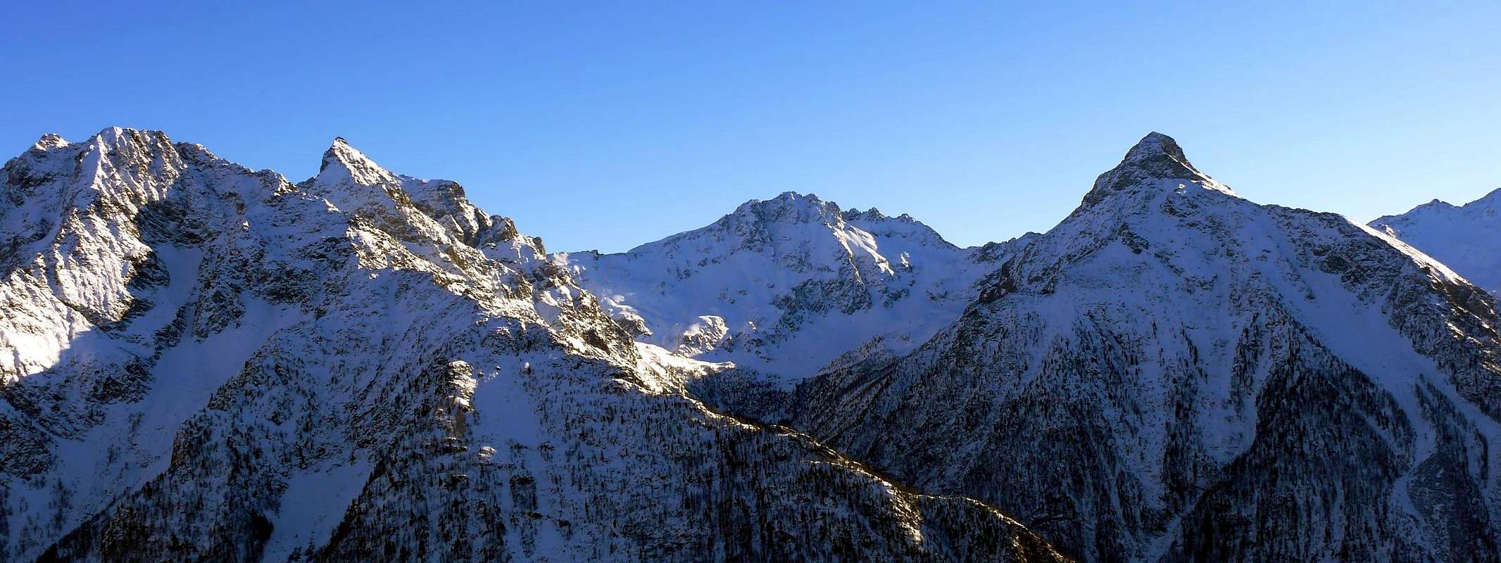
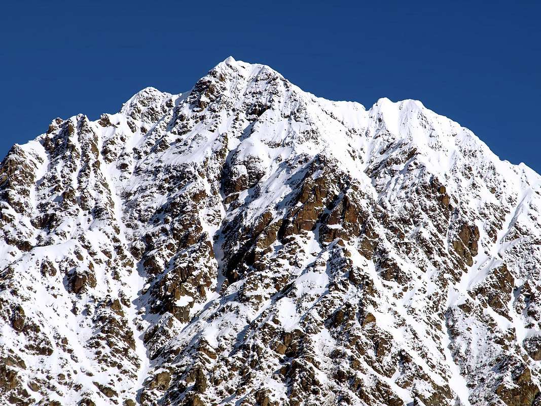
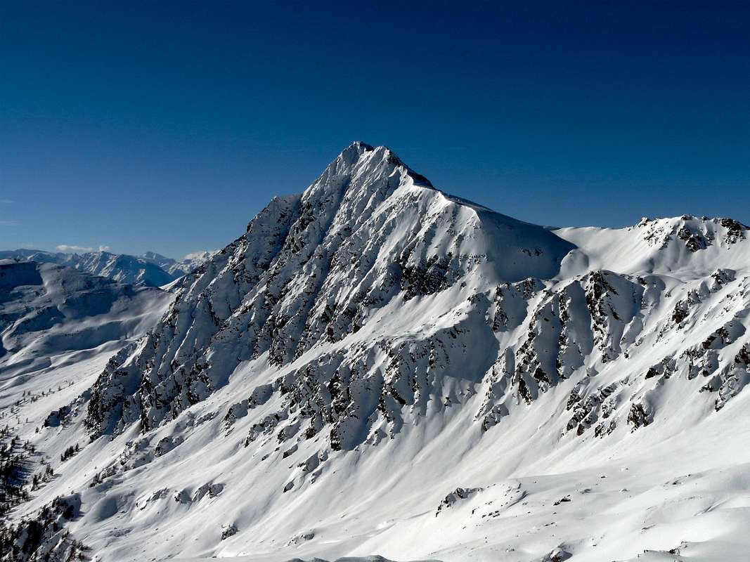
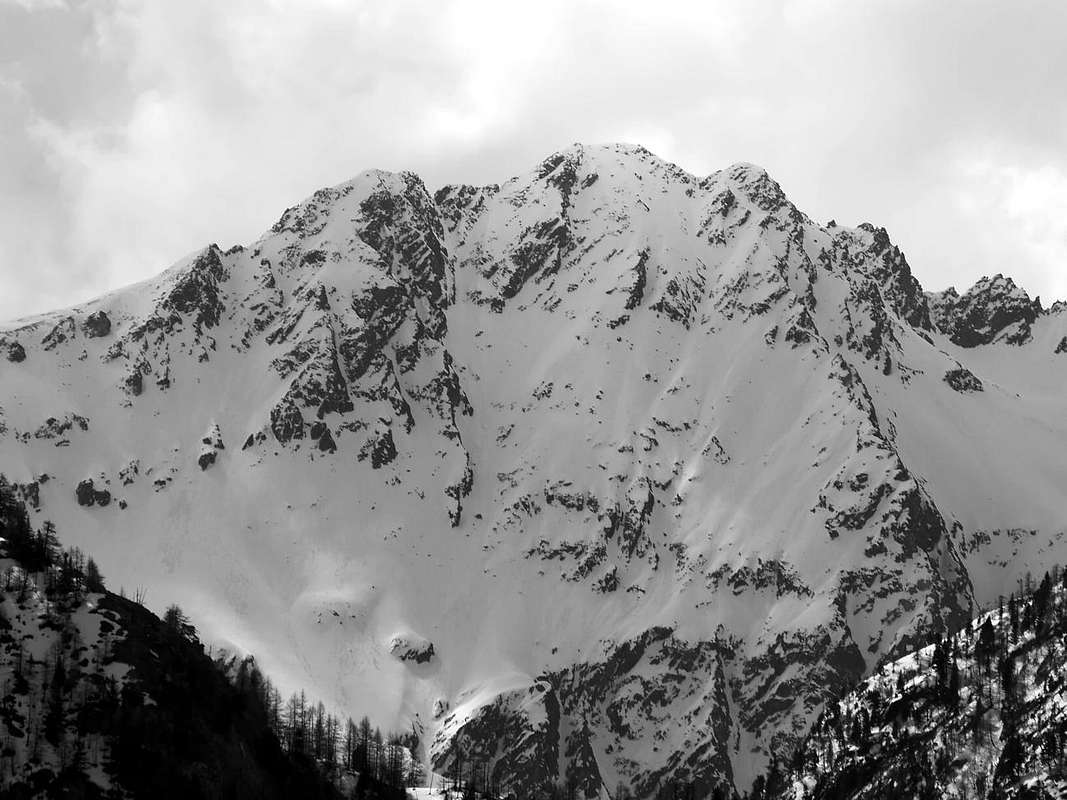
A perfectly triangular shaped mountain when seen from south, but not perfectly identifiable from the other sides, the Monte Faroma in winter looks himalayan, with its long smoking cornices after the snowfalls. In summer its barren appearence makes it almost petty. In any case the Monte Faroma is the highest summit on the ridge descending from Becca di Viou and lies on the watershed between the Colle di Vessona (2.733m) to NE and the Colle di Faroma (2.741m) to WSW.
Montagna dall'aspetto perfettamente triangolare se vista da sud, ma non bene identificabile dagli altri versanti, il Monte Faroma nella stagione invernale ha un qualcosa di himalayano, con lunghe cornici fumanti dopo le nevicate. In estate il suo aspetto arido lo rende quasi insignificante. In ogni caso il Monte Faroma è la vetta più elevata che scende alla Becca di Viou. Si trova sullo spartiacque tra il Colle di Vessona (2.733 m) a N-E e il Colle di Faroma (2.741 m) a O-SO.
First Ascents
Normal route: Captain Casalegno dello Stato Maggiore Sardo, (1832), in ascent and descent through the Northeast Crest from Colle di Vessona.
In winter: Massimo Mila, Toni Ortelli, Fulvio Ratto and Enrico Rizzetti, (Feb 02th, 1958).
NE Crest (Normal Route): Captain Casalegno dello Stato Maggiore Sardo, (1832), in ascent and descent from Lignan in Saint Barthélemy Valley.
SE Face (Right or East Side): Auguste and Ferdinand Darbellay with the mountain-carrier Grégoire Comé, (Sep 15th, 1895), in descent.
SE Wall (Direct Central Via): Osvaldo Cardellina, lone, (Jul 13th, 2008), in ascent from Saint Barthélemy-Chaleby Alp.
N Slope (more Northeastern Sector): Abbot Joseph Maria Henry, lone, (Aug 09th, 1905), in descent.
North Wall (Northern Rib): Osvaldo Cardellina, lone, (Jun 12th, 1999), in ascent from Prarayer-Comba di Vessona.
North-northwestern Face (NW Rib between two couloirs): Osvaldo Cardellina, lone, (Jul 13th, 2008), in descent to Col Faroma-Valchourda Pasture.
Southwestern Ridge (Northwestern Side of Quota 3.038 meters near the Top and final part of West Crest): Aldo Bonacossa and Benedetto Salvi Cristiano, (Apr 27th, 1917), in ascent from Vessona's Comba or small Valley.
Southwestern Ridge (integral from Col Léché): A. Gustavo De Petro and Pompeo Viglino, (Jun 26th, 1920), in ascent from Léché Alp in St. Barthélemy Valley.
Western Crest (integral to Col Faroma): Osvaldo Cardellina, solo, (Jun 12th, 1999), in descent towards Valchourda-Seyvaz Alps in Comba Dèche.
Getting There
BY CAR:
From Torino, Milano, etc: Motorway A5. Exit at Nus.
From Switzerland: through the Grand Saint Bernard Tunnel or the namesake pass.
From France: through Mont Blanc Tunnel or Petit Saint Bernard Pass. It isn't necessary to take Motorway A5: you can drive on SS.26, in the direction of Aosta.
BY PLANE:
Aeroporto "Corrado Gex" Saint Christophe (Aosta).
Route
From the highway toll of Nus (East of Aosta Town) follow toward Nus, from the small central square follow the road leading into the Saint-Barthélemy Valley (bus service). After the small builted areas of Petit Fénis (940m), Blavy (1.056m), Deval (1.257m) and Issologne (1.515m) you get Lignan (1.633m). All'uscita del casello autostradale di Nus (a est della Città di Aosta) proseguire verso il Comune di Nus; dalla piccola piazza al centro del paese seguire la carrozzabile che conduce nella Valle di Saint-Barthélemy (raggiungibile anche in pullman). Dopo aver superato le Frazioni di Petit Fénis (940 m), Blavy (1.056 m), Deval (1.257 m) e Issologne (1.515 m), si raggiunge Lignan (1.633 m). From Lignan (car parking) go toward the Breva Valley and, after passing the small Village of Clemenceau (1.627m) go along the farm road leading to the Pastures of Champanement (2.318m). Here two choices: the longest one, along a stream to the upper Plan Piscina (2.544m), then toward West along a panoramic path all ups and downs up to the Colle di Vessona (2.789m); the shortest, tiring, follows toward the pass on tracks, along a grassy steep small valley up to a small lake wherefrom a little stream flows out. From this point in a short walk you get the path of the previous route getting the Colle. Herefrom, along the NE ridge: it starts wide and detrital then becomes more and more narrow, made of big gneiss stones, very sharp and exposed, and requires an easy scramble on the edge (I°+ UIAA - easier if passed along the grassy edges of the S side). Once on the secondary summit (stone blocks) slightly down to a notch, turning around the last stones you get the eagle nest of the summit, impending the small Valleys of Breva, Dèche and Vessona.
Da Lignan (dopo aver posteggiato l'auto nella piazzola), indirizzarsi verso Vallone di Breva e, dopo aver oltrepassato il Villaggio di Clemenceau (1.627 m), salire lungo la strada poderale che porta all'Alpeggio di Champanement (2.318 m). Dall'alpe si può, con giro più lungo, risalire seguendo il torrente al superiore Plan Piscina (2.544 m); quindi con largo giro verso ovest, su di un sentiero in continuo saliscendi, ma panoramico, si raggiunge il Colle di Vessona (2.789 m). Oppure, con percorso più breve e faticoso, dirigersi in direzione del colle risalendo un valloncello erboso ripido su tracce di pascolo, che sbucano nei pressi di un laghetto, da cui scende un rivo d'acqua. Da questo punto, risalendo brevemente, si torna sul sentiero dell'itinerario precedente raggiungendo il colle. Da quest'ultimo si prosegue per la cresta Nord-Est della montagna, dapprima larga e detritica, poi sempre più stretta sino a divenire in qualche tratto molto sottile ed aerea con grossi blocchi gneissici che, se percorsi sul filo, presentano brevi difficoltà di I°+, peraltro facilmente aggirabili su cenge erbose del versante volto a mezzogiorno. Si raggiunge l'antecima su roccia a blocchi e, in leggera discesa verso un colletto, con breve giro si tocca la cima a nido d'aquila che domina i Valloni di Breva, Dèche e Vessona.
Equipment for the Route
Standard mountaineering equipment.
Difficulty
Normal route - Easy anf for Experienced Hikers. F+.
Campings
Remember that free camping is forbidden (except for emergency reasons, over 2.500m, from darkness until dawn).
Information
Meteo: you can find all the needed informations at the official site of the Valle d'Aosta Region:
"Guida della Valpelline" de l'Abbè Joseph-Marie Henry - Societè Editrice Valdotaine 1925 II Edition e Collana Reprint Musumeci (1986).
"Guida dei Monti d'Italia - Alpi Pennine" (Vol. 2) di Gino Buscaini - Club Alpino Italiano/Turing Club Italiano, Luglio 1970 (In Italian).
"80 itinerari di Escursionismo Alpinismo e Sci Alpinismo in Valle d'Aosta" di Osvaldo Cardellina Ed. Musumeci, Giugno 1977 prima ed. Luglio 1981, seconda ed. Luglio 1984, terza ed. Edizioni in francese prima ed. 25 Febbraio 1978, seconda ed. Marzo 1980.
"Dove andiamo in montagna? in Valle d'Aosta" di Domenico Caresio Edit. Tipografia Ferraro Ivrea, Marzo 1996.
"Diari Alpinistici" di Osvaldo Cardellina e Indice Generale accompagnato da Schedario Relazioni Ascensioni 1964-2019 (unpublished).
Parents refers to a larger category under which an object falls. For example, theAconcagua mountain page has the 'Aconcagua Group' and the 'Seven Summits' asparents and is a parent itself to many routes, photos, and Trip Reports.

 9074 Hits
 90.81% Score
 33 Votes