
-
 4379 Hits
-
 83.1% Score
-
 16 Votes
|
|
Mountain/Rock |
|---|---|
|
|
45.84730°N / 7.21424°E |
|
|
Mountaineering |
|
|
8123 ft / 2476 m |
|
|
Overview
Small round mountain, among the Punta di Menouve (east) and the Valley Barasson (west). And in winter and spring when many ski-mountaneers come to amuse. Fine point of observation on Mont Velan.
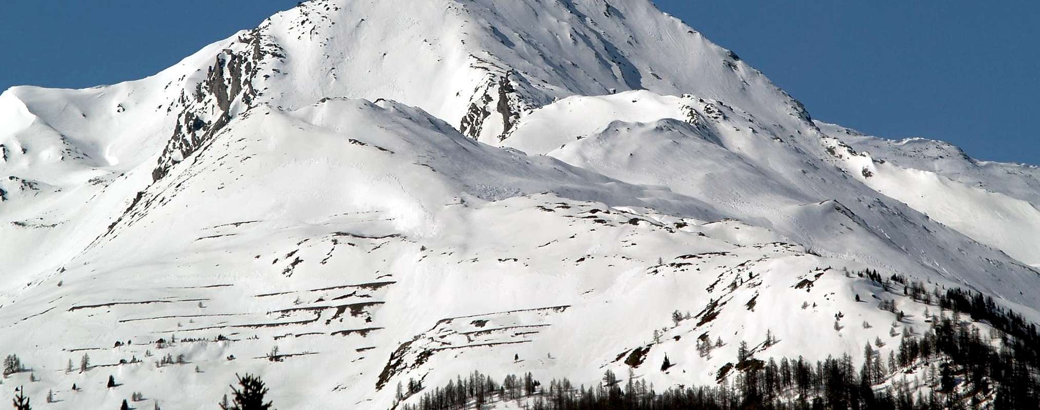
Piccola montagna tondeggiante, fra la Punta di Menouve ad est e la Valle di Barasson a ovest. In inverno e primavera è un'ottima gita scialpinistica frequentata da moltissimi sciatori. Ottimo punto di osservazione sul vicino Mont Velan.
- From Torino, Milano, etc: Motorway A5. Exit Aosta Est.
- From France: through Mont Blanc Tunnel or Petit St. Bernard Pass. It isn't necessary to enter in Motorway A5, you can drive through SS.26 Aosta direction.
- Aeroporto "Corrado Gex" Saint Christophe (Aosta).
Itinerary
From Aosta (583m), along the SS.27 of gran San Bernardo, crossing Gignod (988m) and Etroubles (1.264m), to take to the right the road toward the Fraction of Prailles (1.555m) from where the itinerary begins afoot.Dalla città di Aosta (583 m) salire lungo SS.27 del Gran San Bernardo, e dopo aver superato i paesi di Gignod (988 m) e Etroubles (1.264 m), predere la strada a destra verso la Frazione di Prailes (1.555 m) da dove inizia l'itinerario a piedi.
Route
From the Fraction of Prailles (1.555m) to ascend in direction northwest exceeding the Village of Bezalles (1.680m) and some alpine huts. To go back the forest in north direction until to reach the top of Monteret (2.307m), to Continue the long ascent the back south until to reach the top (2h'30/3h'00). SE exposition mainly. Final ridge often windy. Take care of avalanche risks after fresh snow. Better snow condition: late winter, spring.Descent: Coming back is along the same route or E slope.
Dalla Frazione di Prailles (1.555 m) salire in direzione nord-ovest oltrepassando il Villaggio di Bezalles (1.680 m) e alcune baite. Risalire il bosco in direzione nord fino a raggiungere la cima di Monteret (2.307 m), Continuare la salita lungo la dorsale sud fino a raggiungere la cima (2h'30/3h'00).
Discesa: Per la stessa via di salita o per il versante est.
Difficulty
The rating is Easy (hiking) or BSA (ski-mountaneering).Le difficoltà sono da valutare come Facile escursione o gita per Buoni Sciatori Alpinisti (BSA).
 |
 |
 |
 |
 |
Gear
Normal ski mountaineering & alpine gear. Crampons and ski-crampons required for final ridge.
Campings
Remember that free camping is forbidden (except for emergency reasons, over 2.500m, from darkness until dawn).
Mountain Conditions
- You can get meteo information at the official site of the Regione Valle d'Aosta:
- Valle d'Aosta Meteo
Webcam
- WEBCAM on Aosta Valley:
- Webcam
Books and Maps
BOOKS:
- "Guida delle Alpi Occidentali", di Giovanni Bobba e Luigi Vaccarone C.A.I. Sezione di Torino Volume II (parte II), 25 Maggio 1896.
- "Guida dei Monti d'Italia-Alpi Pennine" (Vol. I°) di Gino Buscaini-Club Alpino Italiano/Turing Club Italiano, Luglio 1971 (in Italian).
- "Diari Alpinistici" di Osvaldo Cardellina e Indice Generale accompagnato da Schedario Relazioni Ascensioni 1964-2019 (unpublished).
 |
 |
 |
MAPS:
- Kompass "Monte Bianco Valle d'Aosta Sentieri e Rifugi" Carta turistica 1:50.000.
- L'Escursionista "Gran San Bernardo Ollomont" Ed. Rimini (n° 5) 1: 25.000.
Important Information
- REGIONE AUTONOMA VALLE D'AOSTA the official site.
- FONDAZIONE MONTAGNA SICURA Villa Cameron, località Villard de la Palud n° 1 Courmayeur (AO) Tel: 39 0165 897602 - Fax: 39 0165 897647.
- SOCIETA' DELLE GUIDE DELLA VALPELLINE Etroubles-Strada Nazionale, n° 13 - Tel +39 0165 78559 - Valpelline-Loc Capoluogo, n° 1 - Tel +39 0165 713502 (AO) Italia.
- A.I.NE.VA. (Associazione Interregionale Neve e Valanghe).
Useful numbers
- Protezione Civile Valdostana località Aeroporto n° 7/A Saint Christophe (Ao) Tel. 0165-238222.
- Bollettino Meteo (weather info) Tel. 0165-44113.
- Unità Operativa di Soccorso Sanitario Tel. 118.