
|
|
Mountain/Rock |
|---|---|
|
|
38.69976°N / 79.53299°W |
|
|
Pendleton |
|
|
Hiking, Mountaineering |
|
|
Spring, Summer, Fall, Winter |
|
|
4861 ft / 1482 m |
|
|
Overview
Spruce Knob is most famous for being the highest point in West Virginia. Less known are the other peakbagging categories for which Spruce Knob has noteworthy rankings. In example, Spruce Knob is not only the West Virginia State Highpoint, the peak is also the highest point of the Allegheny Mountains and Appalachian Plateaus. Spruce Knob is also the 13th-most isolated peak (with approximately 175 miles of isolation) in the contiguous United States, the 14th-most isolated U.S. State Highpoint, the 23rd-most prominent (with 2781' of clean prominence) U.S. State Prominence Point, the 24th-highest U.S. State Highpoint, the 25th-most prominent peak in the United States located east of the Mississippi River, and the 28th-highest County Highpoint located east of the Mississippi River. Spruce Knob
Spruce Knob is located within both the Monongahela National Forest and Spruce Knob-Seneca Rocks National Recreation Area (NRA), the latter of which was established during 1965 by the U.S. Congress. This is significant because the Spruce Knob-Seneca Rocks NRA was the first NRA to be designated as part of the USDA Forest Service. The NRA encompasses approximately 100,000 acres. Nearby Seneca Rocks is considered one of the best rock climbing areas in the region.
 Rocky Sub-Alpine Landscape Near Summit
The summit can be attained by driving along decent forest roads and then a short easy walk. The summit has a public observation tower, constructed mostly of stone and steel, from which potentially far-ranging views of the surrounding landscape can be seen. A short trail leads to the summit, or a 0.5-mile loop trail (Whispering Spruce Trail) is also an option and offers more opportunities for scenery and views.
 Summit Observation Tower
Despite being a peak with an elevation below 5000', and unlike many peaks in the southern half of the Appalachian Mountains, Spruce Knob has an alpine look and appeal. The mountain is quite windy at times, causing many of the trees near the summit to be misshapen like Krummholz. The terrain is predominantly spruce forest and meadows, but many of the slopes are noticeably comprised of large talus/boulder slabs. This rock type is mostly Pennsylvanian Pottsville Sandstone, a type of bedrock only found in Pennsylvania, West Virginia, Ohio, and western Maryland.
 Looking Up Talus Slopes On Spruce Knob
Getting There
FROM EAST (starting at I-81 near Harrisonburg, Virginia):
-> Take Exit 247 for US-33 Northbound/Westbound.
-> Follow US-33 for approximately 56 miles, crossing over the Virginia/West Virginia border in the middle section of that route.
-> Approximately one mile beyond Judy Gap (junction of Hwy-28 with US-33), turn left (west) onto County Road (CR) 3314.
NOTE: There might be a sign for Spruce Knob at the intersection of CR-3314 and US-33. If you continue along US-33 and reach the small town of Riverton, you have driven too far north along US-33.
-> Follow CR-3314 for 2.4 miles, until a "Y" intersection with CR-6.
-> Turn left at the "Y" intersection. This main road soon becomes known as Public Road 112.
-> Follow Public Road 112 (generally southwestward) for approximately 7.2 miles, until its intersection with Public Road 104. This intersection is shown on USGS maps as "BM 4532".
-> Turn right (north) and uphill along Public Road 104. Follow Public Road 104 for approximately 1.75 miles to the Spruce Knob parking lot. The parking lot location is shown on USGS maps only as "(Point) 4840".
-> Walk approximately 0.2 miles southbound to the summit and observation tower.
NOTE: An alternative walking option between the parking lot and summit area would be the Whispering Spruce Trail, which only takes a few minutes longer to travel and which arguably has better views is certain directions than the summit area.
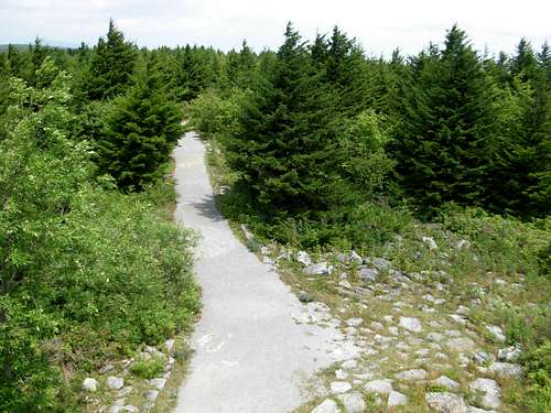 Looking At Trail From Summit
FROM NORTH/WEST (starting at Harman, West Virginia):
-> Head southbound along US-33.
-> After approximately 21.9 miles from Harman, turn right (west) onto CR-3314.
NOTE: There might be a sign for Spruce Knob at the intersection of CR-3314 and US-33. If you continue along US-33 and reach Judy Gap, you have driven too far south along US-33.
-> Follow CR-3314 for 2.4 miles, until a "Y" intersection with CR-6.
-> Turn left at the "Y" intersection. This main road soon becomes known as Public Road 112.
-> Follow Public Road 112 (generally southwestward) for approximately 7.2 miles, until its intersection with Public Road 104. This intersection is shown on USGS maps as "BM 4532".
-> Turn right (north) and uphill along Public Road 104. Follow Public Road 104 for approximately 1.75 miles to the Spruce Knob parking lot. The parking lot location is shown on USGS maps only as "(Point) 4840".
-> Walk approximately 0.2 miles southbound to the summit and observation tower.
NOTE: An alternative walking option between the parking lot and summit area would be the Whispering Spruce Trail, which only takes a few minutes longer to travel and which arguably has better views is certain directions than the summit area.
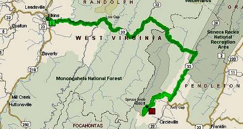 Map Showing Driving Approach From West
Why Drive It When You Can Hike It?
Probably at least 99% of the visitors for Spruce Knob reach the summit via driving to Public Road 104 and/or its upper parking lot. However, on-trail hiking options are available for those willing to do so.Spruce Knob can be reached via the Huckleberry Trail (#533), which extends north along the Spruce Mountain ridgeline. Several trail possibilities exist to reach the Huckleberry Trail:
-> Seneca Creek Trail (#515) to Judy Springs Campground/ Judy Springs Trail (#542) to Huckleberry Trail (#533).
-> Lumberjack Trail (#534, formerly known as Spruce Mountain Trail) to Huckleberry Trail (#533).
------------
For current trail maps and conditions, please contact the Potomac Ranger District at 304-257-4488.
When To Climb
In theory, the peak can be summited year-round. However, snowpack can limit access to the peak anytime between mid-October and mid-April. Public Road 112 and Public Road 104 are each not maintained during snowy/winter months; those roads are commonly snow-covered and/or ice-covered during Winter, causing potential dangerous driving conditions (even for 4WD vehicles) and greatly increasing hiking/snowshoeing/cross-country skiing distance. Spruce Knob is generally recommended for visits between May-September, especially for those visitors coming from beyond West Virginia and/or those not familiar with the conditions in that specific area. Example Of Road Conditions During Winter...
Red Tape
There are currently no permits or fees required to visit Spruce Knob.Public Road 112 and Public Road 104 is not maintained during Winter (snow) season, and snowfall can be expected anytime between mid-October and mid-April during a typical year.
It is recommended to contact the Potomac Ranger District for current road and mountain conditions, prior to visiting the peak.
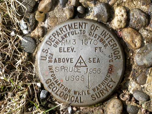 USGS Summit Benchmark
Camping
Spruce Knob is located within the Spruce Knob-Seneca Rocks National Recreation Area (NRA). The NRA contains several fee-for-use campgrounds, most notably the Seneca Shadows Campground and Big Bend Campground. Please visit the NRA website or contact the Potomac Ranger District headquarters for current campground information.Mountain Conditions
LOCAL CONTACT INFORMATION:
Potomac Ranger District: 304-257-4488
Seneca Rocks Discovery Center: 304-567-2827.
The current weather forecast at nearby Seneca Rocks is typically similar to Spruce Knob.
The Snowshoe Mountain Ski Area also typically has forecasts and conditions similar to what should be expected at Spruce Knob.
External Links
The County Highpointers website section dedicated to Spruce Knob can be found at this link.A topography map for Spruce Knob can be found at this link.
The Spruce Knob-Seneca Rocks National Recreation Area website can be found at this link.
The Potomac Ranger District website can be found at this link.
Editor's Note
During late January 2012, I was allowed to adopt this SummitPost page which has significant regional and national importance. With a page score of only 39% at the time of page adoption, this had by far been the lowest rated SummitPost page dedicated to a U.S. State Highpoint. The page was created during 2002 and last edited during 2006, prior to my adoption of the page, so there had been enough time to at least make attempts to improve the limited information on the page and raise the overall page score.I hope my commitment and efforts to making this a better overall page are appreciated.
big_g - Apr 11, 2006 10:05 pm - Voted 10/10
Website link changedRyan Cragun's site on Spruce Knob is now: http://www.genesoc.com/node/305
mutant1 - May 2, 2006 11:22 am - Hasn't voted
Re: Website link changedThanks for the update!
hgrapid - Feb 23, 2009 3:59 pm - Voted 10/10
Re: Website link changedThis link no longer exists
crussellbowden - Dec 18, 2015 12:11 am - Hasn't voted
Re: Website link changedHoly shit that's a weird website after translation.
Alpinist - Oct 26, 2009 2:09 pm - Voted 10/10
USGS markerFor those of you who collect photos of the US geological surver markers for the state HPs, it is located on the ground on the left side of the observation tower as you approach from the parking area.
bmolloy04 - Jun 3, 2017 7:02 am - Hasn't voted
There is another option for the route upI recently completed this Highpoint but instead of opting for the normal drive up route i did it as a pretty strenuous bike ride up the auto road. Makes you feel like you "earned" it a little more. There is a great resource for the route below: http://www.cyclingscenicwv.com/Rides/SpruceKnobClimb/SpruceKnobClimb.html you can also read my trip report on my blog here: http://outdooroutlier.blogspot.com/2017/05/spruce-knob-wv-by-bike-new-way-to-high.html