
|
|
Mountain/Rock |
|---|---|
|
|
38.77600°N / 78.2033°W |
|
|
Warren |
|
|
3368 ft / 1027 m |
|
|
Overview
With rock cliffs and a walk on the Appalachian trail, Mount Marshall is a classic Virginia mountain. Mount Marshall is one of the most accessible Shenandoah peaks from the Washington DC area. It is on the Appalachian trail, and is accessible via a couple points off of Skyline Drive, as well as from a long day hike off of route 211. The summit area provides some very nice views of the Shenadoah Valley and surrounding mountains.
Mount Marshall is actually made up of two summits (North Marshall and South Marshall). North Marshall is the higher of two, (separated by about a mile), and is also referred to as "Mount Marshall".
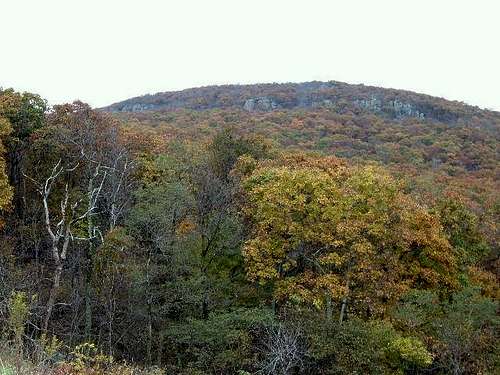 Mount Marshall Cliffs seen from Skyline Drive
South Marshall
South Marshall is 3,212 feet and lies to the South of North Marshall, on the Appalachian Trail. It shares a ridge, and rises 125' above the ridge between North and South Marshall. It can initially be reached via Gravel Springs Gap, where you gain 557' to get to South Marshall's wooded summit.
 |
 |
 |
Getting There
There are two very different routes you can use. One is the common route off of Skyline Drive in Shenandoah National Park. Start at the parking lot at milepost 15.9 or ~17.5 (the longer route). You take the Appalachian trail until you wind around a steep trail until you hit a view point overlooking a cliff. Then it is relatively flat for 1/3 of a mile to the summit. The summit is off to the left of the trail. It is a jagged boulder, with a decent view, and a USGS marker. To find it, you will see some boulders off in a clearing. If you continued on the trail, you would just be going down. Look for the highest point.
The longer trailhead (mp 17.5) is off Skyline Drive at Gravel Springs Gap, with 900 feet of elevation gain, and a 4 mile round trip hike. If you are a die hard hiker who cannot stand hiking from Skyline Drive, then you can take a much longer and more strenous route, accessible from outside the park. For that route, follow Rt 211 south to Rt 622 at Washington, VA. Follow Rt 622 through town along the Rush River to Rt 625. Rt 625 is unpaved, and has a small parking area at the trail head approx. 3 miles from Rt 211.
Here is the information on the long hike.
 |
 |
Red Tape
Shenandoah National Park cost $30 for an annual pass. If you do not live in the DC area, you can pay the $15 fee to enter Skyline Drive ($10 from December-February).
When To Climb
Climb all year. The park, or sections of the park, may be closed if road conditions are poor. Check with the park at 540-999-3500.
Camping
Campsites are not always open during the winter and spring. Backcountry Camping Permits are required and are available free from park headquarters, visitor centers, and entrance stations. Appalachian Trail hikers may self-register for permits on the AT near Rockfish Gap (south) and Chester Gap (north).
Campfires are not permitted (except at pre-constructed fireplaces at backcountry huts and day-use shelters). Groups may not exceed 10 people. For more info consult the park website.
Mountain Conditions
Check with the park at 540-999-3500.
External Links
- Long hike route
Longer hiking route to the summit of Mt. Marshall - Shenandoah National Park
Shenandoah National Park home page - Weather
Weather in nearby area town of Flint Hill
Buz Groshong - Oct 25, 2011 3:38 pm - Hasn't voted
3 Mt. MarshallsActually there are three peaks in that area named for John Marshall: There are North Marshall, South Marshall, and just to the east of them Mount Marshall.
hgrapid - Oct 28, 2011 12:19 pm - Hasn't voted
Are you sure?I thought North and South Marshall were both part of the larger Mount Marshall. That is what it shows on the topo map. I don't see a Mount Marshall to the east. Can you elaborate? I have been up there a number of times, so I am pretty familiar if you can explain further.
Buz Groshong - Oct 30, 2011 12:41 pm - Hasn't voted
Re: Are you sure?The peak to the east, often called "The Peak" on maps is also referred to as "Mount Marshall." Perhaps a note to that effect would be in order.