
-
 17172 Hits
-
 88.19% Score
-
 26 Votes
|
|
Mountain/Rock |
|---|---|
|
|
46.85820°N / 10.09250°E |
|
|
10643 ft / 3244 m |
|
|
Overview
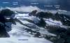
The Silvrettahorn is a beautiful rock pyramid that carries the same name at the rugged mountain group that it is part of. At the base of the mountain there are extensive glaciers. It is not the highest mountain of the Silvretta group, but certainly very representative for the shape of many peaks in this area. The summit of the mountain is marked by a large wooden cross. Climbing this mountain is very rewarding in winter as well as in summer, with an interesting glacier tour (crevasses) to start with, and then some rock scrambling over one of the ridges. The panorama from the summit is spectacular. The Silvrettahorn was first climbed by Jacot, Jegen, and Schlegel (1865). There are routes to the summit from the Wiesbadener Hütte in Austria and the Silvrettahütten in Switzerland.
 |  |  |  |  |
Routes overview
Via the S ridge:
This is a rock scrambling route from the Egghornlücke (3047m) between the Silvrettahorn and the Silvretta-Egghorn. The route follows the S-ridge with some easy climbing (grade I-II; loose rock). The ridge becomes very narrow near the summit. The Egghornlücke can best be reached from the Wiesbadener Hütte (Glacier tour over the Ochsentaler Gletscher). Alternatively, from the Silvrettahütten (Glacier tour over the Silvretta Gletscher, with a short very steep climb to the col; not recommended).
Via the NW ridge:
Easy route over a broad ridge. This route departs from the Silvrettalücke, which can be reached from the SW (Silvretta Gletscher). The Silvrettalücke cannot be gained from the Austrian side without some serious climbing.
Via the W-ridge:
Somewhat more difficult climbing (grade I-II) than the other routes with much loose and bad rock. Not recommended. Route starts from Silvretta Gletscher.
Via the E-ridge:
The german guidebook praises the E-ridge as one of the finest routes of the Silvretta: grade III. But because of melting ice the approach via the Schneeglocken glacier may be tricky.
 |  |
Climbing base
From the Austrian side the Wiesbadener Hütte (2443m) is a good starting point. The Silvrettahorn together with Piz Buin dominate the view from the front of the Wiesbadener Hütte. The Wiesbadener Hütte can be reached by a signposted track from Bieler Höhe (3 hours walk). Bieler Höhe has bus connections to Galtür and further to Landeck. Phone: ++43 (0) 5558 4233. Website: http://www.wiesbadener-huette.com/
On the Swiss side the Silvrettahütten is the best climbing base. There is a signposted path to the hut from Klosters (5-5.5 hours walk). Klosters has a railway station. Phone: +41 (0)81 422 13 06 Website: http://www.sac-stgallen.ch/huetten/silvretta.htm
 |
Getting There
From the Austrian side the best starting point to walk to the Wiesbadener Hütte is Bieler Höhe (2036m). This is a broad water shed between the Montafon valley to the NW and the Paznaun valley to the NE. A road passes over the Bieler Höhe (Silvretta Hochalpstrasse) that connects the cities Bludenz (NW) and Landeck (NE). There is a parking at the Bieler Höhe, but also a bus connection to Galtür and further to Landeck at the end of the Paznaun valley. Landeck can be reached by train from Innsbruck, which has an airport.
From the Swiss side the best starting point to walk to the Silvrettahütten is Klosters, which is on the train line between Davos and Landquart. Landquart connects further by frequent fast train services (1-2 hrs traveling time at most) to the cities Chur and Zürich (the latter with airport). See for bus and train connections the CFF website: http://www.cff.ch/ . Alternatively, by car from Zürich take the motorway 3 to Chur and exit at Landquart and follow the road 28 to Klosters.
Red Tape
No permits required, no summit fees.
 |
When To Climb
This mountain can be climbed all year round. However, winter climbs require a much bigger effort than climbs in summer. Contact the Wiesbadener Hütte for guiding details in winter or look in "Bergtouren und Hüttenübergange in der Silvretta vom Madlenerhaus und der Wiesbadener Hütte. 1996, DAV"
Camping
There are a few campings and many hotels in the Prattigau and Paznaun valleys.
Mountain Conditions
Weather
http://www.alpenverein.at/wetter/index.asp
Miscellaneous Info
Maps
Alpenvereinskarte Blatt 26 Silvrettagruppe (1:25:000)
LKS map 249 Tarasp (1:50:000)
Books
Günther Flaig. Silvretta Alpenvereinsführer alpin. 11th edition 1996, Rother, München ISBN 3-7633-1097-5
Bergtouren und Hüttenübergange in der Silvretta vom Madlenerhaus und der Wiesbadener Hütte. 1996, DAV Wiesbaden.
Lowlands climber - Apr 14, 2005 3:01 pm - Hasn't voted
Untitled CommentMathias, can you give me the reference to the German guidebook, so I can add to the book list? Thanks, Jan.
Mathias Zehring - Apr 14, 2005 3:19 pm - Voted 10/10
Untitled CommentYou already listed the guidebook by Flaig of 1996 - I don't know what is written there about the east ridge. My book is a previous edition:
Walter Flaig, Alpenvereinsfuehrer Silvretta, Bergverlag Rother Munich, 10th edition 1987
Lowlands climber - Apr 14, 2005 4:23 pm - Hasn't voted
Untitled CommentThanks,
I see. The author has actually removed the E-ridge from the book. All routes above grade II have actually been removed from the new version.
Lowlands climber - Oct 4, 2005 4:21 pm - Hasn't voted
Untitled Commentdone, thanks.
Mathias Zehring - Oct 28, 2005 12:42 pm - Voted 10/10
Untitled Commenthmm - you only inserted 2 numbers behind the decimal point. Is there a reason for this?
Lowlands climber - Nov 3, 2005 4:57 pm - Hasn't voted
Untitled CommentYes, there is a reason for this. This is related to one of my professional deformations :-).
It relates to how you determined the coordinates . If these were really determined on the spot by triangulation or military quality GPS (or from a list of coordinates added to the map) I would be in favor of more than 2 decimals.
However if you got them from a cursor reading from a digital map, than there is of course a measurement error. That is why is used two decimals to start with. So if you can be more specific on the way you obtained the coordinates from the map I would be willing to add more decimals.
Mathias Zehring - Nov 4, 2005 12:47 am - Voted 10/10
Untitled Commenthmm - I believe that the coordinates from digital map are more accurate that 2 decimals.
A major feature for the coordinates is the correct setting for the summit symbol on the "interactive map" on the left bar. Clicking on it shows that now the summit symbol is placed somewhere between Silvrettahorn and Schneeglocke.
I don't know how much decimals you need for this - but surely more than two.
Lowlands climber - Nov 4, 2005 6:33 am - Hasn't voted
Untitled Commentok, sounds convincing.
Mathias Zehring - Apr 13, 2005 4:24 pm - Voted 10/10
Untitled Commentthe german guidebook praises the E-ridge as one of the finest routes of the Silvretta: UIAA III. But because of melting ice the approach via the Schneeglocken glacier may be tricky
Lowlands climber - Apr 14, 2005 3:01 pm - Hasn't voted
Untitled CommentMathias, can you give me the reference to the German guidebook, so I can add to the book list? Thanks, Jan.
Mathias Zehring - Apr 14, 2005 3:19 pm - Voted 10/10
Untitled CommentYou already listed the guidebook by Flaig of 1996 - I don't know what is written there about the east ridge. My book is a previous edition:
Walter Flaig, Alpenvereinsfuehrer Silvretta, Bergverlag Rother Munich, 10th edition 1987
Lowlands climber - Apr 14, 2005 4:23 pm - Hasn't voted
Untitled CommentThanks,
I see. The author has actually removed the E-ridge from the book. All routes above grade II have actually been removed from the new version.
Mathias Zehring - Oct 3, 2005 12:16 pm - Voted 10/10
Untitled Commentare not fully correct: I took these one from digital Alpenvereinskarte map:
46.858222 N
10.0925278 E
Lowlands climber - Oct 4, 2005 4:21 pm - Hasn't voted
Untitled Commentdone, thanks.
Mathias Zehring - Oct 28, 2005 12:42 pm - Voted 10/10
Untitled Commenthmm - you only inserted 2 numbers behind the decimal point. Is there a reason for this?
Lowlands climber - Nov 3, 2005 4:57 pm - Hasn't voted
Untitled CommentYes, there is a reason for this. This is related to one of my professional deformations :-).
It relates to how you determined the coordinates . If these were really determined on the spot by triangulation or military quality GPS (or from a list of coordinates added to the map) I would be in favor of more than 2 decimals.
However if you got them from a cursor reading from a digital map, than there is of course a measurement error. That is why is used two decimals to start with. So if you can be more specific on the way you obtained the coordinates from the map I would be willing to add more decimals.
Mathias Zehring - Nov 4, 2005 12:47 am - Voted 10/10
Untitled Commenthmm - I believe that the coordinates from digital map are more accurate that 2 decimals.
A major feature for the coordinates is the correct setting for the summit symbol on the "interactive map" on the left bar. Clicking on it shows that now the summit symbol is placed somewhere between Silvrettahorn and Schneeglocke.
I don't know how much decimals you need for this - but surely more than two.
Lowlands climber - Nov 4, 2005 6:33 am - Hasn't voted
Untitled Commentok, sounds convincing.