
|
|
Mountain/Rock |
|---|---|
|
|
46.87685°N / 10.05184°E |
|
|
Hiking, Mountaineering, Skiing |
|
|
Spring, Summer, Fall, Winter |
|
|
9455 ft / 2882 m |
|
|
Overview
Sonntagspitze from the Litzner Sattel
When the skies are clear, your reward will be fine vistas of mountains near and far. You can see many of the high peaks of the Silvretta group as well as many more others further away, deep into Austria and Switzerland. If you ask me, the best views are to the northeast towards the Silvretta Stausee, which is the biggest of the dammed lakes in the area, and to the northwest towards the impressive shapes of Großlitzner (3109m) and Gross Seehorn (3120m), less than 2 km away. Like the Sonntagspitze, these are border peaks - but unlike the Sonntagspitze, which is a walk up, these two are only accessible to climbers. In fact, there are some fine alpine routes on both of them, including the full traverse of the pair.
The border follows the two main ridges, towards the northwest and the south.
From the summit, the easy northwest ridge descends in a little more than 100 m to the Winterlücke (2832m), a high alpine saddle. Southwest of the saddle, in Swiss territory, lies a bowl shaped basin with a few small lakes. From there a steep, difficult hiking trail leads up to the pass. Beyond the Winterlücke, the NW ridge rises again, first to the unremarkable looking Winterberg (2924m), and then to the earlier mentioned Großlitzner and Gross Seehorn.
On the jagged south ridge, about 400 m from the summit, lies the Klosterpass (2751m). This is another high alpine border crossing, with hiking trails on each side. Although the slopes of the Sonntagspitze between the Klosterpass and Winterlücke are steep and rugged, there is a trail between the two passes. In fact, there is just one way down to the basin below, branching off of this connecting trail from roughly half way, and at about the same elevation as the Klosterpass.
The trail on the Austrian side of the Klosterpass is somewhat easier.North to northeast of the summit, completely in Austria, are the last remains of the dying Glötter Glacier. There is still some ice left, so, obviously, there is no permanent trail. But I won't be surprised that when the ice disappears in the years to come, a trail will be constructed.
In contrast to the relatively gentle northwest ridge and north to northwestern slopes, the other sides and ridges are steeper, and none more so than the sheer east face. And there, right next to the summit, lies a small group of almost vertical rock towers, called "Schwarze Wand". That's German for "Black Wall", even though the rocks are not especially dark. The only reason I can think of that explains the name is that they are often in the shade, thanks to the combination of the sheer shape of the towers and their closeness to the slightly higher Sonntagspitze.
Summit panorama to the northwest.
The nearby saddle on the left is the Winterlücke. Towering in the middle are GroßLitzner and Gross Seehorn. And right of center is the Litzner Sattle.
Getting There
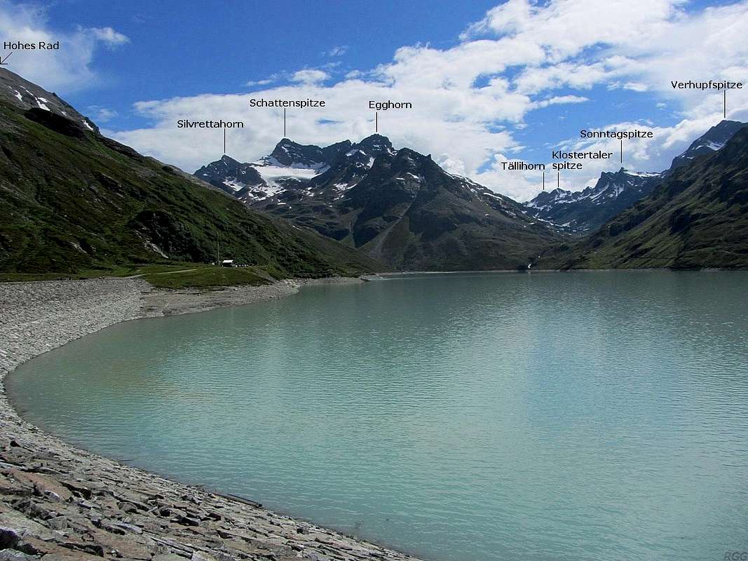
Looking across the Silvretta Stausee from Bielerhöhe
From Austria
The nearest road is at Bielerhöhe, a high pass on the north side of the Silvretta Stausee, a big, dammed lake. The "Silvretta Hochalpenstraße", a toll road, goes over the pass, connecting the Montafon valley on the northwest with the Paznaun valley on the northeast. There is ample (free) parking space. Bielerhöhe is also easy to reach by bus from both sides.An alternative start would be the south side of the Vermunt Stausee, a bit lower along the same toll road and some 4 km further west. There is some room to park just south of the lake. If you arrive by public transport, ask the driver to let you off at the "Obervermuntwerk" at the south side of the lake. In winter the toll road is closed, but Bielerhöhe can still be reached from the village of Partenen, high in the Montafon valley, by the Vermuntbahn cable car and then onward by shuttle bus.
From Switzerland
The nearest settlement of note is Klosters-Monbiel, in winter a ski resort. Klosters has a train station, and Swiss trains have a fine reputation. Usually they go often and are punctual; Unfortunately they are also rather expensive.From Klosters go east to Monbiel, at the start of the Sardasca valley. The map shows a dirt road going further up the valley from there. I haven't been there, but I believe it's closed to the public. If you have more information about this, please let me know so I can update the page.
Routes
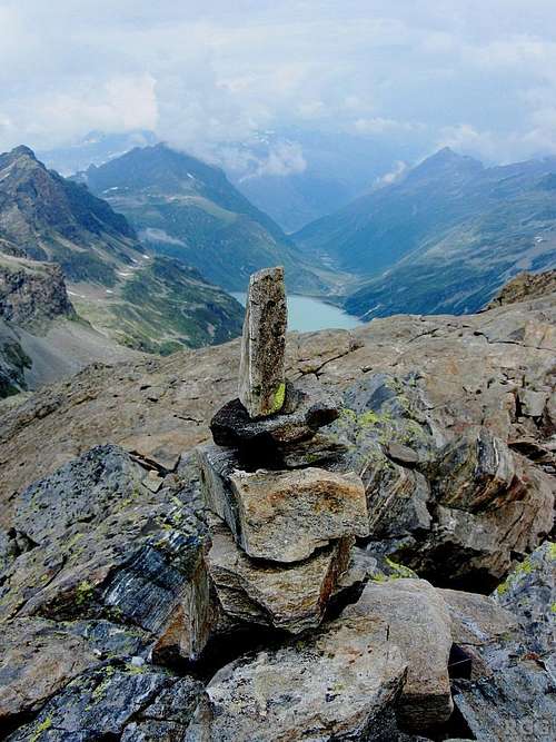
A brand new cairn on the summit
OSM map of the surrounding trails. N.B. The Sonntagspitze is well south of the center of the map to show more of the trails on the Austrian side, since it's easier to reach from there.
Getting to the Winterlücke
To get to the Winterlücke you can choose between the Austrian or Swiss side.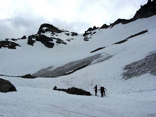
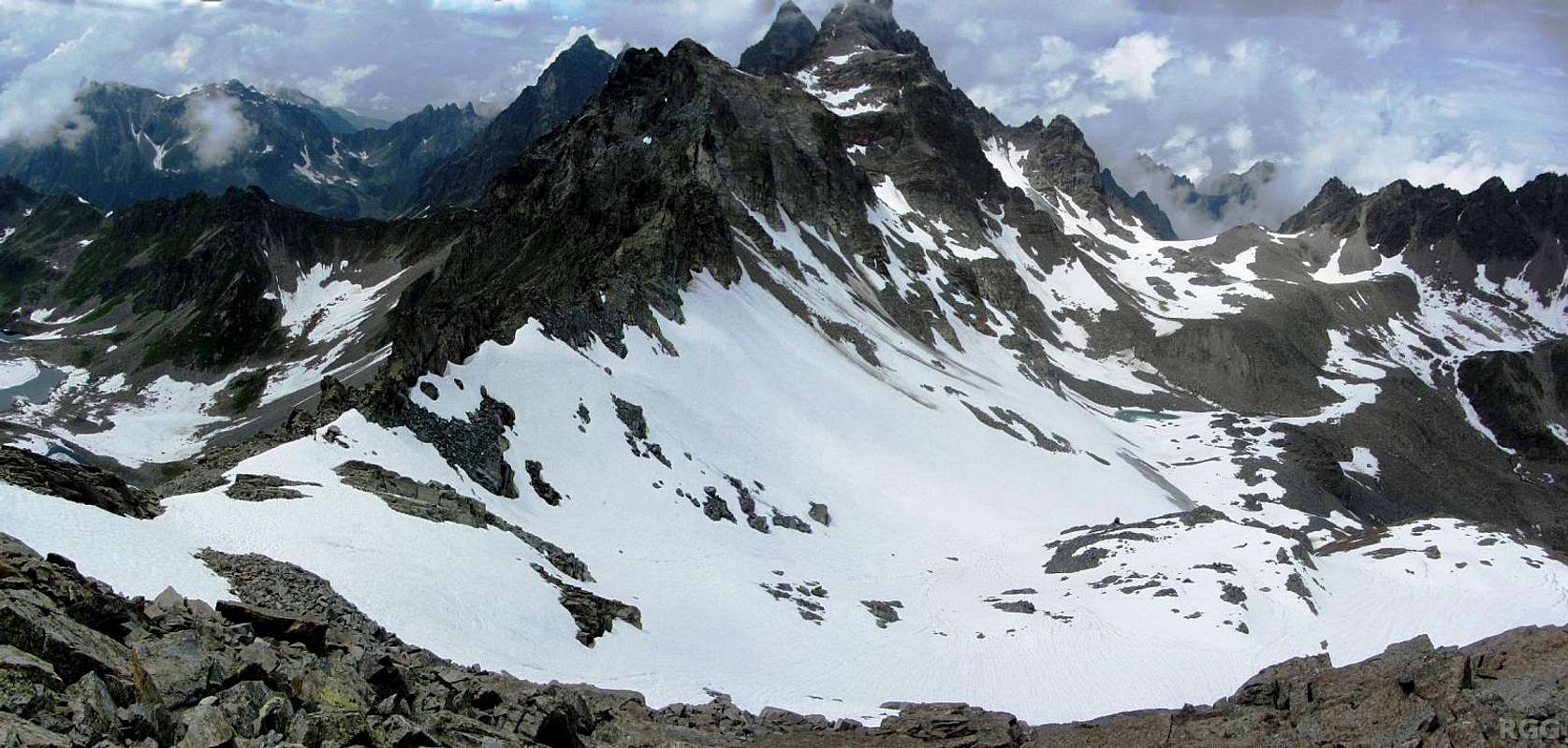
The Sonntagspitze, with the last remains of the Glötter Glacier. The old snow, left over from spring, makes it look a lot bigger than it really is.
The Winterlücke is the obvious gap just right of the peak.
From the roadside at Bielerhöhe in Austria, the ascent takes about 3 hours. The route starts out on the west side of the Silvretta Stausee. Just before its southern tip, keep to the right, into the Klostertal. At around 2300 m take a right turn and head up the trail into the steeper Verhupftäli, towards the Litzner Sattel. Well before getting there, at roughly 2650 m, leave the trail to the left. Turn gradually to the south, following the contours. Soon you'll reach the Glötter Glacier. Now make your way up to the Winterlücke, which is the obvious low point on the ridge between the Sonntagspitze and Winterberg. If there is no snow on the ice, you may need crampons for a short section.
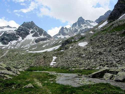
Looking back up the Kromer valley.
The Litzner Saddle is in the center.
Alternatively you can take the scenic route back over the Litzner Sattel and then down the Kromer valley. This alternative descent takes about 5 hours to Bielerhöhe. A minor detour along the way leads you to the Saarbrücker Hütte, high in the Kromer valley, where you can have refreshments or stay for the night.
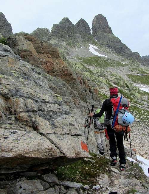
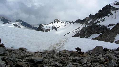
Hiking up to the Klosterpass from Austria.On the right is the Schwarze Wand.

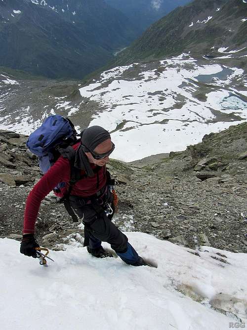
On the steep traverse between Klosterpass and Winterlücke, with the trail invisible from the snow.
Falling here is not an option!
Almost at the Winterlücke on the Swiss side. Well below is the bowl with the lakes, still further down is the Sardasca valley.
This detour adds up to an hour to the ascent when compared to the route over the Glötter Glacier.
In winter and spring, you can ski down from the summit on the Austrian side, initially down the Glötter Glacier, and then either to the Silvretta Stausee, or over the Litzner Sattel (2737m), which implies a short ascent, and then down the Kromer valley to the Vermunt Stausee.
On the Swiss side, the nearest roads and villages are a bit far away for a day hike, so a visit from the south makes more sense as part of a longer trip in the area. Fortunately the Swiss Silvrettahütte is nearby.
Red Tape
The Silvretta High Alpine road is a toll road. Even bus passengers have to pay extra on top of the bus ticket.When to Climb
Anytime. When there is enough snow, which normally lasts well into spring, bring skis.Accommodation
The Montafon and the Paznaun valleys are popular ski areas in winter, and there are plenty of accommodation options.In addition, there are a number of mountain refuges nearby. A selection:
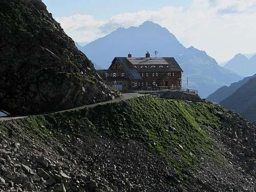
The Saarbrücker Hütte
- Madlenerhaus: A refuge located next to the road, a few minutes west of Bielerhöhe. Excellent food!
- Saarbrücker Hütte: About 3 km NNW of the Sonntagspitze, this refuge high in the Kromer valley sits on the Kleinlitzner west ridge. From the refuge you can't see the Sonntagspitze, but from Kleinlitzner you can.
- Silvrettahütte: This Swiss refuge is about 3 km south of the Sonntagspitze.
- Klostertaler Hütte: This small refuge has no warden; you have to fend for yourself. It's owned by the DAV, the German Alpine Club. You need a key (called the "AV‑Schlüssel") to get in, available at the DAV. Click on the link for the contact details for the refuge to find out more.
Books and Maps
For the Sonntagspitze you don't need one, but a good (German) guidebook for the area is the Silvretta Alpenvereinsführer, Günther Flaig, Rother Verlag. ISBN 978-3-7633-1097-5.The best map is the Alpenvereinskarte Silvrettagruppe, 1:25 000. On the Austrian side, it covers everything that matters, but on the Swiss side it doesn't cover Klosters-Monbiel.
An alternative is the Freytag&Bernd map WK 374, 1:50 000. It covers a larger area, including Klosters, and shows most of the trails in the area. However, it so happens that the map is a bit lacking for the Sonntagspitze: on the Swiss side, the only trail is the one to the Klosterpass; the one to the Klosterlücke is missing.
External Links
| Bielerhöhe | In German and English. |
| A nice ski trip report | In German, but there isn't much text and there are plenty of scenic pictures. |