
-
 4386 Hits
-
 80.49% Score
-
 12 Votes
|
|
Mountain/Rock |
|---|---|
|
|
46.76888°N / 10.05762°E |
|
|
Download GPX » View Route on Map |
|
|
Hiking, Skiing |
|
|
Summer, Fall, Winter |
|
|
9350 ft / 2850 m |
|
|
Overview
 Piz Murtera and Piz Chasté Piz Murtera and Piz Chasté |
The Swiss part of the Inn River Valley, named Engadin divides in two sections, Oberengadin, from the river's source to the town Zernez and Unterengadin between Zernez and the Austrian border. At the village Susch in Unterengadin the river turns its south-northerly course into an easterly one in a big bend and it is here that three mountain ranges touch each other. South-east of the bend you will find the Sesvenna Group, to the south-west the Albula Alps and to the north there is the Silvretta Group, with its highest mountain, Piz Linard almost right above the river. Just opposite, across Val Saglians, there is a lookout peak, perfectly located above the bend: Piz Chasté.
Seen for itself, Piz Chasté does not look impressive, even though it rises some 1500m above the Inn River Valley. Its lower slopes are covered in pine forests with the upper slopes cattle pastures. Only the very top, though also round-headed, is somewhat rocky, though of questionable quality. Straying from the normal route into the north face can quickly become very dangerous. Also, the traverse to Chasté's higher neighbour Piz Murtera, is a difficult and brittle block traverse and thus rarelly done.
 East slopes East slopes |  From Lavin From Lavin |  South slopes South slopes |
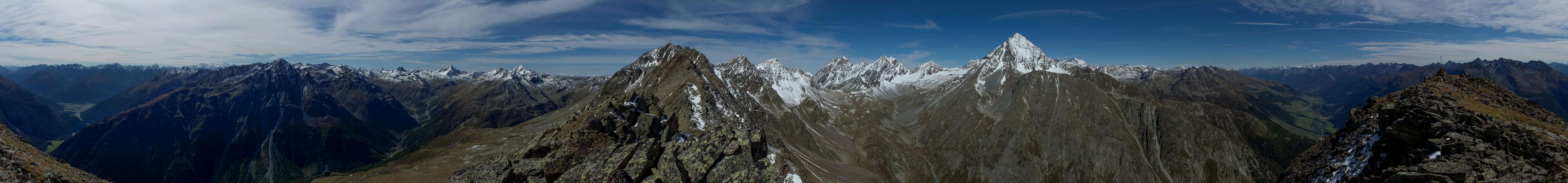
But you mainly visit Piz Chasté for its views. After 1300m elevation gain from Röven or 1500m elevation gain from Susch you are treated to an exceptional vista. The close-up views include the three mountain ranges mentioned above and the far away viwes include the Bernina Group, Livigno and Ötztal Alps. To the west the massive bulk of Tödi looms beyond the Rhine River Valley.
 Val Saglians Val Saglians | ||
 Bernina Group Bernina Group |  Cima de Piazzi Cima de Piazzi |  Tödi Tödi |
 Sesvenna Group Sesvenna Group |  Flüela Schwarzhorn Flüela Schwarzhorn | 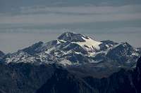 Weißkugel Weißkugel |
 Piz Linard Piz Linard |  Plattenhörner Plattenhörner |  Wildspitze Wildspitze |
But the most impressive mountain lies just across Val Saglians. As you reach the east ridge of Piz Chasté, suddenly a wonderful view opens towards the perfectly shaped pyramid of Piz Linard. The higher you get, the lower Piz Glims retreats to reveal Linard with Plattenhörner and Piz Zadrell, especially wonderful to behold if there is still snow on these mountains.
360° Summit Panorama
  |
Getting There
 View across Unterengadin towards the Ötztal Alps
There are two trailheads for Piz Chasté, both located on B28, the road which connects Davos with Susch in Unterengadin. The lower of the two trailheads is in Susch itself while the higher one is at Röven, a locality to the south of the road. There is a small parking space beside an intersection with a bus stop.
From Switzerland:
- Take motorways A3 and A13 to Landquart
- Switch to B28 across Flüelapass to Susch
From Austria:
- Take motorway A12 to Landeck
- Switch to B180 to Pfunds
- A bit after the village switch to B184, which turns into B27 after you cross the Swiss - Austrian border
- At Susch switch to B28 to Flüelapass
From Italy:
- Take motorway A22 to Bozen / Bolzano
- Switch to SS38, passing Meran / Merano to Schluderns / Sluderno
- Turn west onto SS41, which turns into B28 after the Swiss - Italian border across Ofenpass / Pass dal Fuorn to Zernez and Susch
Route
The normal route to Piz Chasté is an easy hike for most of its way. From Röven a narrow path crosses the south slopes of the mountain until it reaches the forest road, which comes up from the second trailhead at Susch. After some giant switchbacks the road ends on a balcony above Unterengadin Valley with fantastic views along both sides of the bend of the river.From the balcony a scarcely marke trail leads up to the summit of Piz Chasté. Avoid the avalanche construction to the left, instead hike along the top of the back which leads to the summit cone. The regular route now heads across the south slopes to head for the summit through a steep and brittle gully (nasty on the descent). Alternatively you can hike the east ridge directly, which is steep and somewhat exposed. Do not try to climb across the north face even though this appears the shortest and most logical route. You'll end up on steep scree slopes which fall all the way down into the valley underneath.
Red Tape
 |
No Red tape here. Some of the meadows on the southern and eastern slopes of Piz Chasteé are owned privately and can be fenced in to herd sheep or cattle. Close the gates and don't disturb the animals. There is a lot of avalanche construction on the upper slopes beneath the summit cone. Keep informed about avalanche conditions before venturing onto the mountain in winter.
Accommodation
Weather Conditions
Maps & Books
Maps
- Digital Maps
- www.swissgeo.ch
- www.austrianmap.at
- Silvretta-Verwallgruppe
Kompass Digital Map GPS4041
ISBN: 3-85491-276-5
- www.swissgeo.ch
- Regular Maps
- Unterengadin-Nationalpark
Kompass Map WK 98
1:50.000
ISBN: 3-85491-331-1
- Silvretta-Verwallgruppe
Kompass Map WK 41
1:50.000
ISBN: 3-85491-047-9
- Nationalpark Zernez,
Swisstopo Map 459T
1:50000
ISBN: 978-9602125731
- Silvretta
Swisstopo Map 1198
1:25000
ISBN: 978-9602122280
- Unterengadin-Nationalpark
Books
- Rudolf Weiss / Siegrun Weiss
- Arlberg Silvretta
L. Mallaun
Kompass Guide WF 910
Kompass Verlag
ISBN: 3-85491-316-8
- Silvretta Alpin
Günter Flaig
Alpenvereinsführer
Rother Verlag
ISBN: 3-7633-1097-5
Rother Verlag
ISBN: 3-7633-4043-2